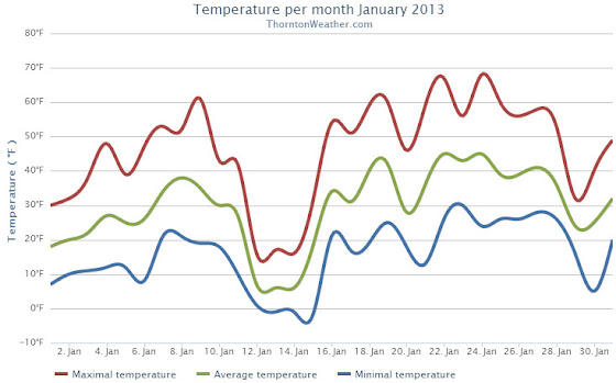
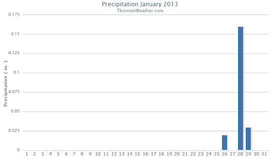
Looking back at January 2013 the numbers reveal a month that wasn’t particularly extraordinary by any measure. Temperatures were slightly below average and precipitation was a bit less than normal.
The first half of the month was notable for cold while the second half for the most part was considerably warmer.
Temperatures for the first three days were well below normal before we entered a brief period with above average temperatures. That was followed by very cold days on the 12th and 13th when high temperatures only reached the teens. Most of the following two weeks were notable for highs in the 50s and 60s.
The month started out extraordinarily dry with a mere 0.3 inch of snow being recorded during the first 27 days. On the 28th though we received a decent little shot of snow to drive up the numbers.
The average temperature for the month came in at 29.7 degrees. This was a full degree below the Denver January average of 30.7 degrees. At the official Denver station at Denver International Airport, the monthly average was slightly warmer at 30.3 degrees.
Temperatures in Thornton ranged from a high of 67.8 degrees on the 24th down to a low of -2.4 degrees on the 15th. Denver recorded a highest temperature of 66 degrees, also on the 24th, and a low of -12 degrees on the 12th.
There were no temperature records set during the month.
In terms of precipitation, an anemic 0.21 inch was measured in Thornton while Denver fared better with 0.31 inch. The January average is 0.41 inch so both locations were a good bit below normal.
Snowfall was similarly light with Thornton recording 3.7 inches, most of which fell during the storm on the 28th and 29th. Out at DIA Denver officially measured 4.6 inches for the month. Average for January is 7.0 inches.
None of the precipitation or snowfall measurements were records.
Click here to view Thornton’s January 2013 Climate Summary


From the National Weather Service:
...THE DENVER CLIMATE SUMMARY FOR THE MONTH OF JANUARY 2013...

CLIMATE NORMAL PERIOD 1981 TO 2010
CLIMATE RECORD PERIOD 1872 TO 2013

WEATHER         OBSERVED          NORMAL DEPART LAST YEAR`S
                 VALUE   DATE(S) VALUE   FROM    VALUE DATE(S)
                                          NORMAL
................................................................
TEMPERATURE (F)
RECORD
 HIGH              76   01/27/1888
 LOW              -29   01/09/1875
HIGHEST            66   01/24        76     -10       66 01/21
LOWEST            -12   01/12       -29      17       -6 01/11
AVG. MAXIMUM     44.6              44.0     0.6     50.3
AVG. MINIMUM     16.0              17.4    -1.4     21.6
MEAN             30.3              30.7    -0.4     36.0
DAYS MAX >= 90      0               0.0     0.0        0
DAYS MAX = .01         4               4.1    -0.1        4
DAYS >= .10         1               0.9     0.1        1
DAYS >= .50         0               0.0     0.0        0
DAYS >= 1.00        0               0.0     0.0        0
GREATEST
 24 HR. TOTAL    0.22   01/28 TO 01/29

SNOWFALL (INCHES)
RECORDS
 TOTAL           24.3   1992
TOTALS            4.6               7.0

DEGREE_DAYS
HEATING TOTAL    1067              1063       4      891
 SINCE 7/1       3300              3531    -231     3325
COOLING TOTAL       0                 0       0        0
 SINCE 1/1          0                 0       0        0

FREEZE DATES
RECORD
 EARLIEST     09/08/1962
 LATEST       06/08/2007
EARLIEST                        10/07
LATEST                          05/05
..................................................

WIND (MPH)
AVERAGE WIND SPEED              8.8
RESULTANT WIND SPEED/DIRECTION   4/205
HIGHEST WIND SPEED/DIRECTION    38/290    DATE 01/24
HIGHEST GUST SPEED/DIRECTION    45/290    DATE 01/24

SKY COVER
POSSIBLE SUNSHINE (PERCENT)   MM
AVERAGE SKY COVER           0.50
NUMBER OF DAYS FAIR            8
NUMBER OF DAYS PC             20
NUMBER OF DAYS CLOUDY          3

AVERAGE RH (PERCENT)     48

WEATHER CONDITIONS. NUMBER OF DAYS WITH
THUNDERSTORM              0     MIXED PRECIP               0
HEAVY RAIN                0     RAIN                       0
LIGHT RAIN                1     FREEZING RAIN              0
LT FREEZING RAIN          0     HAIL                       0
HEAVY SNOW                1     SNOW                       1
LIGHT SNOW                5     SLEET                      0
FOG                       7     FOG W/VIS
