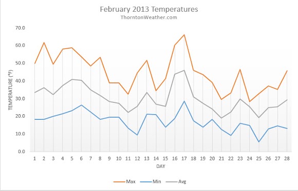
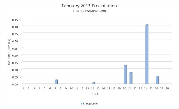
Northeastern Colorado’s warm, dry winter took a bit of a turn during February as temperatures cooled and we finally received some much needed precipitation.
The month started out with a continuation of the warmer and drier conditions we saw in January. Temperatures for the first days of the month were routinely near or above the 50 degree mark with little precipitation.
That changed on the 9th when low pressure moved through and served to cool things down to below normal. No precipitation was seen however.
The following 10 days were relatively calm and tranquil but with varying temperatures. The month’s high temperature was recorded on the 17th.
As we entered the last part of the month the weather turned much more unsettled and finally delivered a healthy dose of winter. A weak system on the 19th and 20th brought light snow and was followed a few days later by a more significant system on the 24th.
The waning days of the month saw mostly below normal temperatures and one more day of light snow.
The average temperature in Thornton during February 2013 was 30.3 degrees. Out at Denver International Airport, Denver officially had an average of 30.1 degrees. Both were well below the historical February average of 32.5 degrees.
Temperatures in Thornton ranged from a high of 66.2 degrees on the 17th down to the lowest reading of 5.7 degrees on the 25th. Only two days in Thornton failed to climb above freezing.
Denver saw its highest reading of 63 degrees on the 17th and lowest of 5 degrees on the 22nd with six days failing to climb above 32 degrees. All 28 days of the month saw low temperatures below the freezing mark at both locations.
Precipitation was the real weather highlight of February 2013 given how dry the season had been up to then. Thornton recorded 0.71 inches in its bucket while DIA saw 0.77 inches. Average for February is 0.37 so both locations enjoyed above normal measurements.
In terms of snowfall, Thornton measured 11.9 inches of the white stuff. Out at the airport they bested our area with 14.1 inches. Historically February averages a mere 5.9 inches so both were well above normal.
Click here to view the ThorntonWeather.com February 2013 Climate Summary


From the National Weather Service:
...THE DENVER CO CLIMATE SUMMARY FOR THE MONTH OF FEBRUARY 2013...

CLIMATE NORMAL PERIOD 1981 TO 2010
CLIMATE RECORD PERIOD 1872 TO 2013

WEATHER         OBSERVED          NORMAL  DEPART  LAST YEAR`S
                 VALUE   DATE(S)  VALUE   FROM    VALUE  DATE(S)
                                          NORMAL
................................................................
TEMPERATURE (F)
RECORD
 HIGH              77   02/28/2006
                        02/04/1890
 LOW              -25   02/01/1951
                        02/08/1936
HIGHEST            63   02/17        70      -7       65  02/25
LOWEST              5   02/22       -14      19        3  02/11
AVG. MAXIMUM     43.3              46.2    -2.9     38.7
AVG. MINIMUM     16.9              18.9    -2.0     18.1
MEAN             30.1              32.5    -2.4     28.4
DAYS MAX >= 90      0               0.0     0.0        0
DAYS MAX = .01         6               5.3     0.7        7
DAYS >= .10         4               0.7     3.3        2
DAYS >= .50         0               0.0     0.0        1
DAYS >= 1.00        0               0.0     0.0        0
GREATEST
 24 HR. TOTAL    0.43   02/24 TO 02/24           02/02 TO 02/03

SNOWFALL (INCHES)
RECORDS
 TOTAL           22.1   1912
TOTALS           14.1               5.7

DEGREE_DAYS
HEATING TOTAL     972               908      64     1055
 SINCE 7/1       4272              4439    -167     4380
COOLING TOTAL       0                 0       0        0
 SINCE 1/1          0                 0       0        0

FREEZE DATES
RECORD
 EARLIEST     09/08/1962
 LATEST       06/08/2007
EARLIEST                        10/07
LATEST                          05/05
....................................................

WIND (MPH)
AVERAGE WIND SPEED              10.3
RESULTANT WIND SPEED/DIRECTION   2/229
HIGHEST WIND SPEED/DIRECTION    35/360    DATE  02/15
HIGHEST GUST SPEED/DIRECTION    44/010    DATE  02/15

SKY COVER
POSSIBLE SUNSHINE (PERCENT)   MM
AVERAGE SKY COVER           0.60
NUMBER OF DAYS FAIR            5
NUMBER OF DAYS PC             16
NUMBER OF DAYS CLOUDY          7

AVERAGE RH (PERCENT)     51

WEATHER CONDITIONS. NUMBER OF DAYS WITH
THUNDERSTORM              0     MIXED PRECIP               0
HEAVY RAIN                0     RAIN                       0
LIGHT RAIN                1     FREEZING RAIN              0
LT FREEZING RAIN          0     HAIL                       0
HEAVY SNOW                1     SNOW                       4
LIGHT SNOW               10     SLEET                      0
FOG                       9     FOG W/VIS
