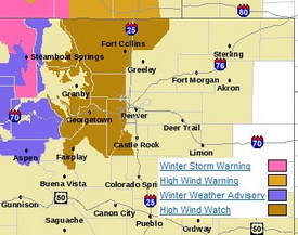
The relative calm of recent days is about to be replaced with high winds not unlike what we saw last week. Winds will increase tonight and continue through Wednesday east of the Continental Divide. Areas west of I-25 to the Divide and in the north and central mountain areas will be under a High Wind Watch from late tonight through Wednesday night.
Much like last week, the usual suspect areas west of I-25 are the places to watch. Fort Collins, Boulder and the western suburbs of Denver are going to get the worst of the wind. The Peak to Peak Highway, Highway 287 north of Fort Collins, the Boulder Turnpike west of Broomfield, and Highway 93 between Boulder and Golden are naturally going to be prime targets.
Wind gusts in excess of 80 mph can be expected in these areas but as we saw last week, other parts of the metro area can receive their fair share of wind as well. As usual, it is best to put away anything in your yards that could be become a missile and if you are driving in the high wind areas, particular along a north / south route, be prepared for extremely gusty conditions.
| Get more local news and weather information on Examiner.com. This article and many more are posted to the Denver Weather Examiner site. |
 |
The good news is that the downslope winds will also bring warmer temperatures – not that you will want to be outside in the wind. Wednesday we will be well above normal with temperatures in the mid 50’s and Thursday could reach the low 60’s. There is a slight chance of snow Friday but that isn’t looking to amount to much.
