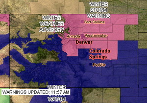
The National Weather Service has issued a Winter Storm Warning for Denver and much of northeastern Colorado in anticipation of a significant storm now approaching the state. The warning takes the place of the previously issued watch and signifies the increased potential for a major snow event. The warning goes into effect at 6:00am Thursday morning and runs through 6:00am Friday.
Computer models are beginning to coalesce around solutions that involve snow amounts that could exceed a foot along the Palmer Divide and the foothills. Snow will begin falling in the foothills in the morning and by midday will encompass the entire Front Range. By the time the storm ends, much of the metro area will have in excess of six inches of snow. Tomorrow afternoon’s commute is almost certainly going to be a rough one.
The spring snowstorm could be our biggest storm to date for the 2008 – 2009 winter season. We are desperately in need of moisture so while it may be troublesome, we really need the precipitation.
