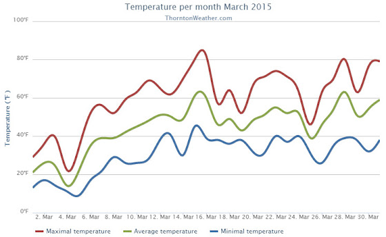
The month of March was relatively uneventful and lacked any sort of real weather drama. What was notable was the dry conditions and unseasonably warm temperatures that dominated for the most part.
March started out considerably colder than normal with the first five days of the month seeing temperatures around 20 degrees below normal. A light shot of snow was recorded on the fourth of the month, a reading that would be our biggest snowfall for the period.
Temperatures began to turn warmer on the sixth with above normal readings recorded through the 16th of the month. We even managed two 80+ degree days on the 15th and 16th.
Denver actually saw its earliest 80 degree reading in history on the 16th. The previous earliest 80 degree reading occurred on March 18, 1907.
Unsettled conditions interrupted the warmth on the 25th with a light snowfall and colder temperatures.
We then bounced right back to the dry, mild conditions for the balance of the month.
Thornton’s average temperature for the month came in at 44.9 degrees. This was well above the long term Denver average of 40.4 degrees. Out at DIA, the Mile High City’s reading was very similar at 45.0 degrees.
Temperatures in Thornton ranged from a high of 82.6 degrees on the 16th down to a low of 9.2 degrees on the 5th of the month. At the airport, Denver’s maximum for the month of 81 degrees came on the 16th with its lowest of 2 degrees on the 5th.
Denver officially broke two temperature records in March 2015. On March 6th the high temperature of 79 degrees broke the record high for the date (previously 76 degrees set in 2013). Also, on the 16th, the high temperature reading of 81 degrees was a record (previously 75 degrees in 2012).
In terms of precipitation, the rain bucket totals fell well short of the March average of 0.92 inch. Here in Thornton a mere 0.49 inches was recorded while Denver saw quite a bit more with a measurement of 0.79 inches.
March is historically our snowiest month but that was certainly not the case in 2015. Thornton snowfall totally only 2.8 inches and Denver was at 2.9 inches. Both were well below the average of 10.7 inches.
Click here to view Thornton’s March 2015 climate report.


CLIMATE REPORT
NATIONAL WEATHER SERVICE BOULDER, CO
633 AM MDT WED APR 1 2015

...................................

...THE DENVER CO CLIMATE SUMMARY FOR THE MONTH OF MARCH 2015...

CLIMATE NORMAL PERIOD 1981 TO 2010
CLIMATE RECORD PERIOD 1872 TO 2015

WEATHER         OBSERVED          NORMAL  DEPART   LAST YEAR`S
                 VALUE   DATE(S)  VALUE   FROM    VALUE  DATE(S)
                                          NORMAL
................................................................
TEMPERATURE (F)
RECORD
 HIGH              84   03/26/1971
 LOW              -11   03/28/1886
HIGHEST            81   03/16/2015                    73  03/09
LOWEST              2   03/05/2015                     4  03/02
AVG. MAXIMUM     58.9              54.4     4.5     55.8
AVG. MINIMUM     31.2              26.4     4.8     25.9
MEAN             45.0              40.4     4.6     40.9
DAYS MAX >= 90      0               0.0     0.0        0
DAYS MAX <= 32      2               1.9     0.1        2
DAYS MIN <= 32     12              23.6   -11.6       23
DAYS MIN <= 0       0               0.1    -0.1        0
PRECIPITATION (INCHES)
 RECORD
  MAXIMUM         4.56   1983
  MINIMUM         0.03   2012
TOTALS           0.79              0.92   -0.13     0.83
DAILY AVG.       0.03              0.03    0.00     0.03
DAYS >= .01         5               5.9    -0.9        9
DAYS >= .10         3               2.4     0.6        2
DAYS >= .50         0               0.3    -0.3        0
DAYS >= 1.00        0               0.1    -0.1        0
GREATEST
 24 HR. TOTAL    0.34   03/19 TO 03/19

SNOWFALL (INCHES)
TOTALS            2.9              10.7

DEGREE_DAYS
HEATING TOTAL     611               763    -152      739
 SINCE 7/1       4724              5202    -478     5258
COOLING TOTAL       0                 0       0        0
 SINCE 1/1          0                 0       0        0

FREEZE DATES
RECORD
 EARLIEST     09/08/1962
 LATEST       06/08/2007
EARLIEST                        10/07
LATEST                          05/05
........................................................

WIND (MPH)
AVERAGE WIND SPEED              9.9
RESULTANT WIND SPEED/DIRECTION   3/198
HIGHEST WIND SPEED/DIRECTION    36/260    DATE  03/23
HIGHEST GUST SPEED/DIRECTION    45/260    DATE  03/23

SKY COVER
AVERAGE SKY COVER           0.50
NUMBER OF DAYS FAIR           12
NUMBER OF DAYS PC             12
NUMBER OF DAYS CLOUDY          7

AVERAGE RH (PERCENT)     51

WEATHER CONDITIONS. NUMBER OF DAYS WITH
THUNDERSTORM              0     MIXED PRECIP               0
HEAVY RAIN                0     RAIN                       1
LIGHT RAIN                5     FREEZING RAIN              0
LT FREEZING RAIN          0     HAIL                       0
HEAVY SNOW                0     SNOW                       4
LIGHT SNOW                3     SLEET                      0
FOG                       7     FOG W/VIS <= 1/4 MILE      4
HAZE                      4

-  INDICATES NEGATIVE NUMBERS.
R  INDICATES RECORD WAS SET OR TIED.
MM INDICATES DATA IS MISSING.
T  INDICATES TRACE AMOUNT.
