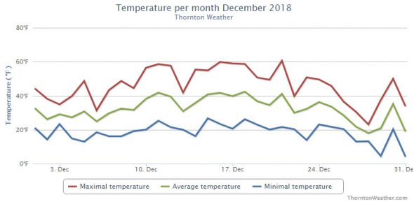
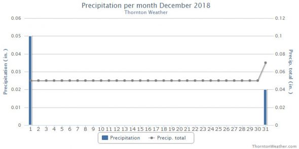
Thornton’s December was lacking in terms of any sort of real weather drama. Temperatures were relatively mild for much of the month and precipitation was fleeting.
Above normal temperatures were the general rule for the first part of the month. It was only the last week of the month when Arctic air arrived and we saw temperatures drop considerably. We saw only two measurable snow events, neither of which amounted to much.
Overall, Thornton’s average temperature for the month was 30.8 degrees. This was nearly a full degree above Denver’s long term December average of 30.0 degrees. Out at DIA where the Mile High City’s official measurements are taken, it was a good bit warmer with an average of 32.5 degrees.
Temperatures in Thornton ranged from a high of 60.6 degrees on the 21st down to a low of 4.5 degrees on the morning of the 29th. Denver’s warmest reading of 63 degrees also came on the 21st and its coldest, 0 degrees, on the 31st.
Denver averages 0.35 inches of precipitation during December. Thornton fell well short with a mere 0.07 inches. Out at the airport, even less was realized with 0.03 being recorded. This puts December 2018 into the books as one of the driest Decembers ever recorded.
Ten driest December’s in Denver weather history (since 1872):
INCHES
0.00 – 1881
TRACE – 1905
0.01 – 1906, 1895
0.03 – 1977, 1931, 2018
0.04 – 2004, 1890
0.05 – 2002, 1995
Thornton recorded a mere 0.9 inches of snow during the month, the majority of which fell on the last day of the month. Denver saw 0.5 inches, all on the 31st. Both fall well short of the long term Denver average for December snowfall of 8.5 inches and put December 2018 on the list of the ten least snowy Decembers recorded.
Ten least snowy December’s in Denver weather history:
TRACE – 1905, 1906, 2002
0.1 – 1928
0.4 – 1890
0.5 – 1935, 2018
0.6 – 1995
0.7 – 1977, 1895
Click here to view Thornton’s December 2018 climate report.


CLIMATE REPORT
NATIONAL WEATHER SERVICE DENVER/BOULDER CO
936 AM MST TUE JAN 1 2019

...................................

...THE DENVER CO CLIMATE SUMMARY FOR THE MONTH OF DECEMBER 2018...

CLIMATE NORMAL PERIOD 1981 TO 2010
CLIMATE RECORD PERIOD 1872 TO 2018

WEATHER         OBSERVED          NORMAL  DEPART  LAST YEAR`S
                 VALUE   DATE(S)  VALUE   FROM    VALUE  DATE(S)
                                          NORMAL
................................................................
TEMPERATURE (F)
RECORD
 HIGH              79   12/05/1939
 LOW              -25   12/22/1990
                        12/24/1876
HIGHEST            63   12/21        62       1       69  12/12
LOWEST              0   12/31        -4       4       -4  12/24
AVG. MAXIMUM     46.1              42.8     3.3     48.3
AVG. MINIMUM     18.8              17.1     1.7     18.0
MEAN             32.5              30.0     2.5     33.2
DAYS MAX >= 90      0               0.0     0.0        0
DAYS MAX <= 32      4               5.8    -1.8        4
DAYS MIN <= 32     31              29.4     1.6       28
DAYS MIN <= 0       1               2.0    -1.0        1

PRECIPITATION (INCHES)
RECORD
 MAXIMUM         5.21   1913
 MINIMUM         0.00   1881
TOTALS           0.03              0.35   -0.32     0.21
DAILY AVG.       0.00              0.01   -0.01     0.01
DAYS >= .01         1               4.1    -3.1        4
DAYS >= .10         0               1.1    -1.1        1
DAYS >= .50         0               0.1    -0.1        0
DAYS >= 1.00        0               0.0     0.0        0
GREATEST
 24 HR. TOTAL    0.03   12/31 TO 12/31

SNOWFALL (INCHES)
TOTALS            0.5               8.5

DEGREE_DAYS
HEATING TOTAL     999              1086     -87      979
 SINCE 7/1       2372              2468     -96     2150
COOLING TOTAL       0                 0       0        0
 SINCE 1/1       1026               769     257      881

FREEZE DATES
RECORD
 EARLIEST     09/08/1962
 LATEST       06/08/2007
EARLIEST                        10/07
LATEST                          05/05
.................................................................

WIND (MPH)
AVERAGE WIND SPEED              9.6
RESULTANT WIND SPEED/DIRECTION   2/222
HIGHEST WIND SPEED/DIRECTION    39/010    DATE  12/12
HIGHEST GUST SPEED/DIRECTION    53/010    DATE  12/12

SKY COVER
POSSIBLE SUNSHINE (PERCENT)   MM
AVERAGE SKY COVER           0.50
NUMBER OF DAYS FAIR            6
NUMBER OF DAYS PC             22
NUMBER OF DAYS CLOUDY          3

AVERAGE RH (PERCENT)     51

-  INDICATES NEGATIVE NUMBERS.
R  INDICATES RECORD WAS SET OR TIED.
MM INDICATES DATA IS MISSING.
T  INDICATES TRACE AMOUNT.
