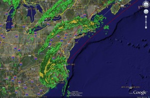
What could probably be called “storm weekend” for the east coast hit in earnest early Saturday morning as Tropical Storm Hanna made landfall along the North Carolina / South Carolina border. With sustained winds of 60 mph the center of Hanna was located about 25 miles west-northwest of Wilmington, N.C. as of 3:00am MDT. The storm will follow the eastern seaboard today where heavy rain and strong winds are expected and tropical storm warnings have been issued from Virgina to Boston. Travel delays, flooding and some beach erosion along the coast are an almost certainty.
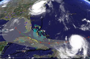
Everyone is really keeping a wary eye on Hurricane Ike, a storm that has the potential to cause serious damage. As of 3:00am MDT was 400 miles west of Mayaguana in the Turks Islands and moving west-southwest at at 16 mph. With winds of 115 mph Ike is a category three hurricane. Some fluctuations in intensity are expected over the next 48 hours but it should remain a major hurricane. Models indicate the storm will pass through the Florida straights with Cuba having the potential to suffer a big hit from the storm Monday and into Tuesday.

One thing that has changed over the last 36 hours or so is Ike’s forecast path. Initially expected to “hook” and turn north onto Florida, it now looks like the storm will pass just off the southern tip of the state and head into the Gulf of Mexico. This of course is not good news for the storm weary states along the Gulf Coast. Further, some convection is expected once it hits the gulf and if this occurs, the storm will strengthen, possibly to a category 4 storm. Ike is still too far out to draw too many conclusions on where its ultimate path will lead and the models all differ on their opinions. However, once the storm enters the Gulf of Mexico toward the middle of next week, Gulf Coast residents should be prepared to evacuate if needed.
For the latest on the storms’ locations, please visit the ThorntonWeather.com Hurricane Tracker.
