|
All posts by Thornton Weather
An overblown link between hurricanes and global warming
|
Deadly Hurricane Matthew downgraded, but still dangerous
|
October 9 to October 15: This Week in Denver Weather History

Denver has yet to get a taste of wintry weather this year as we continue what has been a very dry period the last few months. In the past that hasn’t always been the case and our look back at this week in Denver weather history shows that heavy, winter-like snowstorms can and do strike in October.
From the National Weather Service:
9
In 1910…light smoke from forest fires in the mountains was sighted over the city.
In 1982…northwest winds gusted to 49 mph at Stapleton International Airport.
9-10
In 2005…a major winter storm brought heavy…wet snowfall to the Front Range mountains…eastern foothills…portions of metro Denver…and the Palmer Divide. Snow accumulations ranged from 8 to 26 inches with drifts from 3 to 4 feet in places. The heaviest snow occurred to the east and southeast of the city…closing most major highways in that area…including I-70 from Denver to Limon. The Red Cross opened four shelters for people who were stranded along I-70 in eastern Colorado. Since many trees had not yet shed their leaves…the storm caused significant tree damage. One woman in Denver was killed when a tree branch… 8 to 10 inches in diameter…snapped under the weight of the heavy…wet snow and struck her as she was shoveling her driveway. Xcel Energy reported power outages to about 35 thousand customers. Several incoming flights were delayed at Denver International Airport. Snow totals included: 16 inches in the foothills near Boulder…12 inches at Genesee and near Golden…22 inches near Watkins…19 inches near Bennett…17 inches southeast of Aurora…14 inches near Parker…13 inches near Castle Rock…12 inches in centennial… 11 inches in Parker…and 10 inches at Denver International Airport and in Littleton. While many areas of metro Denver received heavy snow…others experienced almost entirely rain. This included west and northwest metro Denver…Boulder…and Longmont. Rainfall amounts were significant as storm totals ranged between 1.50 and 2.50 inches. The steady rainfall triggered 3 rockslides in foothills canyons. Two of the slides occurred on State Highway 119 in Boulder Canyon and the longest slide…7 feet in length…on State Highway 74 in Bear Creek Canyon at Idledale. North winds were sustained to around 23 mph with gusts to 31 mph at Denver International Airport on the 9th. The high temperature of only 34 degrees on the 10th was a record low maximum for the date. The low temperature on both days was 32 degrees.
10
In 1901…an evening thunderstorm produced east winds to 43 mph with gusts to 48 mph.
In 1949…strong winds believed to be the worst in Boulder’s history at the time caused over 100 thousand dollars damage in the city. Peak winds were estimated to 85 mph at Valmont…just east of Boulder. High winds also occurred over most of metro Denver and caused damage to trees…window glass…and utility lines. The damage was most pronounced over the northwest metro area…including north Denver and Lakewood. Falling tree branches caused damage to parked autos and houses. Wind gusts to 70 mph were recorded at Stapleton Airport.
In 1964…lightning struck and killed a 13-year-old boy…while he was riding his bicycle along a tree-lined residential street in south Denver. Apparent microburst winds gusted to 54 mph at Stapleton International Airport.
10-11
In 1986…the first significant snowstorm of the season produced 2 to 5 inches of snow over metro Denver with 5 to 10 inches in the foothills west of Denver. Wondervu recorded the most snow from the storm…13 inches. The heavy wet snow caused numerous power outages. The storm was accompanied by strong north winds with gusts to 41 mph recorded on the 10th. The first snowfall of the season totaled 3.1 inches at Stapleton International Airport with only one inch on the ground due to melting. The strong cold front accompanying the storm cooled the temperature from a high of 73 degrees on the 10th to a high of only 33 degrees on the 11th…which was a record low maximum for the date.
10-12
In 1969…the second heavy snowstorm in less than a week dumped nearly a foot of snow across metro Denver and plunged the area into extremely cold temperatures for so early in the season. Snowfall totaled 11.0 inches at Stapleton International Airport. North winds gusting to 26 mph produced drifts up to 2 feet deep. Temperatures dipped from a high of 52 degrees on the 10th to a record low for the date of 10 degrees on the 12th. There was additional damage to trees and power and telephone lines from heavy snow accumulations and icing. Travel was restricted or blocked by drifting snow in both the mountains and on the plains east of Denver.
11
In 1997…damaging winds ahead of an approaching storm system developed in the foothills and spread across metro Denver. Winds gusted to 88 mph at conifer…71 mph at the National Center for Atmospheric Research on the mesa in Boulder… And 53 mph at Denver International Airport. Several trees and street signs were blown down with scattered power outages reported throughout metro Denver. In Arvada…a car window was blown out by a strong wind gust.
In 2013…high winds occurred in and near the Front Range Foothills. Peak gusts included: 85 mph at Rooney Road…84 mph…2 miles south of Marshall; 82 mph at Rocky Flats National Wind Technology Center and Wondervu; 79 mph at the Mesa Lab at NCAR and 75 mph…3 miles south-southwest of Boulder; 73 mph in Superior and 68 mph in Golden. The wind downed trees and power lines. As a result…scattered electrical outages affected 20000 Xcel Energy customers through the morning hours. The main outages affected the cities of Boulder…Golden and Lakewood. Smaller outages were reported in areas of Gold Hill…Ward… Westminster and Wheat Ridge.
11-12
In 1901…an apparent cold front produced northeast winds sustained to 42 mph with gusts to 48 mph on the 11th. General rain changed to snow overnight and totaled 2.0 inches. This was the first snowfall of the season. Total precipitation was 0.32 inch.
11-13
In 1892…apparent post-frontal rainfall totaled 3.33 inches in downtown Denver over the 3 days. A trace of snow on the 12th melted as it fell. Rainfall of 2.58 inches on the 12th into the 13th was the greatest 24-hour precipitation ever recorded during the month of October. Northwest winds were sustained to 48 mph with gusts as high as 55 mph on the 12th.
12
In 1873…smoke from several very large forest fires was sighted along the mountains.
In 1923…post-frontal rain changed to snow and totaled 4.0 inches. North winds were sustained to 14 mph.
In 1978…northeast winds gusting to 35 mph with a strong cold front briefly reduced visibility to 2 miles in blowing dust at Stapleton International Airport.
12-13
In 2001…overnight peak wind gusts to 82 mph and 70 mph were measured atop Niwot Ridge and Squaw Mountain…respectively.
12-14
In 1969…record breaking extremely cold temperatures for so early in the season occurred. The high temperature of 26 degrees on the 13th was two degrees lower than the previous record minimum temperature of 28 degrees for the date set in 1885. The high temperature of 24 degrees on the 12th exceeded the record low temperature (22 degrees set in 1885) for the date by only 2 degrees. In addition… 3 new record low temperatures for the dates were set. The low temperature dipped to 10 degrees on the 12th breaking the old record (22 degrees in 1885) by 12 degrees. On the 13th the mercury plunged to a low of 3 degrees breaking the old record (28 degrees in 1885) by 25 degrees. On the 14th the temperature reached a minimum of 4 degrees breaking the old record (25 degrees in 1966) by 21 degrees.
Continue reading October 9 to October 15: This Week in Denver Weather History
Hurricane Matthew tracker
After devastating parts of Haiti and Cuba, Hurricane Matthew now has its sights set on the southeastern United States. Florida Governor Rick Scott has warned that the storm could be catastrophic and ordered the evacuation of nearly 2 million residents.
Follow the massive storm’s progress using the live tracker below. For more information, get the latest public advisories from the National Hurricane Center.
Thornton’s October 2016 preview: Fall returns, hopefully with precipitation
 With the first full month of fall here, October usually brings one of the quietest weather months in the Denver area with plenty of mild, sunny days and clear, cool nights. Given the lack of precipitation of the last few months though, we certainly would welcome some moisture.
October is historically the second sunniest month and conditions are generally calm.
However we also will usually see our first taste of winter during the month with the first freeze and first snowfall of the season. Temperatures as well will start to drop and by the end of the month the average nighttime lows are below freezing.
For complete details on our historical October weather and what we can expect in the coming month, read our complete October weather preview here.
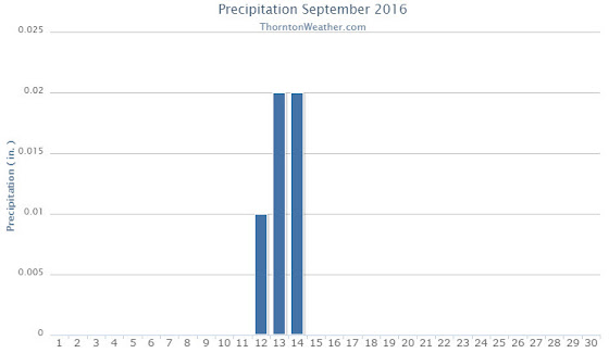
September 2016 weather recap: A very dry month with near normal temperatures
The month of September was overall a pleasant one however that came at a price. A very distinct lack of precipitation led to dry conditions, a trend that had started earlier in the summer.
High pressure was the general rule for the month and that helped to ensure that any significant weather potential was steered away from the state. A few troughs and cold fronts mixed things up but in the end, we only saw precipitation on three days during the month and the amounts were negligible.
Thornton’s average temperature for the month came in at 63.7 degrees. This was just slightly above Denver’s long term average for September of 63.4 degrees. Out at the airport where Denver’s official measurements are taken, it was a good bit warmer with an average of 66.0 degrees.
Temperatures here ranged from a high of 91.6 degrees on the 5th of the month down to a low of 39.8 degrees on the 24th. DIA recorded a maximum of 93 degrees, also on the 5th, and a low of 37 degrees on the 10th.
In terms of precipitation, Thornton saw a measly 0.05 inches fall into our rain bucket. The airport fared far better with 0.28 inches. However, both measurements were well below the September average for Denver of 0.96 inches. The reading in Thornton would have been low enough to tie for the third driest reading in Mile High City history.
Click here to view Thornton’s September 2016 climate report.

From the National Weather Service:
CLIMATE REPORT
NATIONAL WEATHER SERVICE DENVER/BOULDER CO
933 AM MDT SAT OCT 1 2016

...................................

...THE DENVER CO CLIMATE SUMMARY FOR THE MONTH OF SEPTEMBER 2016...

CLIMATE NORMAL PERIOD 1981 TO 2010
CLIMATE RECORD PERIOD 1872 TO 2016

WEATHER         OBSERVED          NORMAL  DEPART  LAST YEAR`S
                 VALUE   DATE(S)  VALUE   FROM    VALUE  DATE(S)
                                          NORMAL
................................................................
TEMPERATURE (F)
RECORD
 HIGH              97   09/06/2013
                        09/05/2013
                        09/04/1995
 LOW               17   09/29/1985
HIGHEST            93   09/05        91       2       92  09/02
LOWEST             37   09/10        35       2       44  09/19
AVG. MAXIMUM     82.3              78.5     3.8     85.2
AVG. MINIMUM     49.7              48.3     1.4     53.5
MEAN             66.0              63.4     2.6     69.4
DAYS MAX >= 90      6               3.4     2.6        7
DAYS MAX <= 32      0               0.0     0.0        0
DAYS MIN <= 32      0               0.8    -0.8        0
DAYS MIN <= 0 0 0.0 0.0 0 PRECIPITATION (INCHES) RECORD MAXIMUM 5.61 2013 MINIMUM T 1892 1944 TOTALS 0.28 0.96 -0.68 0.11 DAILY AVG. 0.01 0.03 -0.02 0.00 DAYS >= .01         4               6.5    -2.5        3
DAYS >= .10         1               3.3    -2.3        0
DAYS >= .50         0               0.6    -0.6        0
DAYS >= 1.00        0               0.1    -0.1        0
GREATEST
 24 HR. TOTAL    0.18   09/12 TO 09/12           08/31 TO 09/01

SNOWFALL (INCHES)
RECORDS
 TOTAL            0.0              1.3
RECORD SEPTEMBER 17.2                      1971

DEGREE_DAYS
HEATING TOTAL      64               125     -61        9
 SINCE 7/1         79               141     -62       27
COOLING TOTAL      99                76      23      148
 SINCE 1/1        861               764      97      861

FREEZE DATES
RECORD
 EARLIEST     09/08/1962
 LATEST       06/08/2007
EARLIEST                        10/07
LATEST                          05/05
.....................................................

WIND (MPH)
AVERAGE WIND SPEED              9.5
RESULTANT WIND SPEED/DIRECTION   2/171
HIGHEST WIND SPEED/DIRECTION    37/170    DATE  09/23
HIGHEST GUST SPEED/DIRECTION    51/200    DATE  09/04

SKY COVER
POSSIBLE SUNSHINE (PERCENT)   MM
AVERAGE SKY COVER           0.40
NUMBER OF DAYS FAIR           13
NUMBER OF DAYS PC             13
NUMBER OF DAYS CLOUDY          4

AVERAGE RH (PERCENT)     45

WEATHER CONDITIONS. NUMBER OF DAYS WITH
THUNDERSTORM              6     MIXED PRECIP               0
HEAVY RAIN                0     RAIN                       0
LIGHT RAIN                6     FREEZING RAIN              0
LT FREEZING RAIN          0     HAIL                       0
HEAVY SNOW                0     SNOW                       0
LIGHT SNOW                0     SLEET                      0
FOG                       4     FOG W/VIS <= 1/4 MILE      3
HAZE                      4

-  INDICATES NEGATIVE NUMBERS.
R  INDICATES RECORD WAS SET OR TIED.
MM INDICATES DATA IS MISSING.
T  INDICATES TRACE AMOUNT.
Florida braces for Hurricane Matthew as track swings closer
|
September 2016 top shots: Monthly photo slideshow
The month of September is typically one of the more pleasant months in Colorado. Temperatures are usually comfortable and there is not normally a lot of weather drama. That however does not mean there aren’t plenty of photo opportunities.
Wildlife is still quite active along the Front Range and flowers will hold on to their petals for at least the first part of the month. Then of course there is the weather which you never know what to expect. Thunderstorms, heavy rain, and even snow are a possibility.
- Slideshow updated October 4, 2016
- To learn more about how to send your photo to us for inclusion in the slideshow, see below the slideshow.
Showcasing images captured by ThorntonWeather.com readers as well as some of our own, our monthly slideshow covers the entire gamut of weather-related imagery.
Sunsets, sunrises, wildlife and of course every type of weather condition are vividly depicted in images captured from yours and our cameras.
| [flickr_set id=”72157670754216514″] |
What is missing in the slideshow above? Your photo!
Our monthly photo slideshow is going to feature images that we have taken but more importantly images that you have captured. The photos can be of anything even remotely weather-related.
Landscapes, current conditions, wildlife, pets, kids. Whimsical, newsy, artsy. Taken at the zoo, some other area attraction, a local park, a national park or your backyard. You name it, we want to see and share it!
Images can be taken in Thornton, Denver or anywhere across the extraordinary Centennial State. We’ll even take some from out of state if we can tie it to Colorado somehow.
We’ll keep the criteria very open to interpretation with just about any image eligible to be shown in our slideshows.
What do you win for having your image in our slideshow? We are just a ‘mom and pop’ outfit and make no money from our site so we really don’t have the means to provide prizes. However you will have our undying gratitude and the satisfaction that your images are shared on the most popular website in Thornton.
To share you images with us and get them included in the slideshow just email them to us or share them with ThorntonWeather.com on any of the various social media outlets. Links are provided below.
So come on, get those camera’s rolling!
- Email: info@ThorntonWeather.com
- Facebook: https://www.facebook.com/ThorntonWeather
- Google+: https://plus.google.com/+Thorntonweather
- Twitter: @ThorntonWeather (https://twitter.com/thorntonweather)
October 2 to October 8: This Week in Denver Weather History
October is usually a relatively calm weather month in Denver but can see some interesting events. In our look back at this week in Denver weather history we see tornadoes, damaging wind and of course snow.
From the National Weather Service:
2
In 1903…southwest winds were sustained to 42 mph with gusts as high as 60 mph. The strong Chinook winds warmed the temperature to a high of 78 degrees.
In 1910…an apparent dry microburst produced sustained northeast winds to 43 mph.
In 1934…a trace of rain was the only precipitation of the month. This was the driest October on record.
3
In 1875…very dense haze hid the mountains from view as observed from the city.
In 1933…rainfall of just 0.01 inch was the only precipitation of the month. This was the second driest October on record.
In 1954…the low temperature cooled to only 60 degrees…the all-time record high minimum for the month October.
3-4
In 1969…the first snowfall of the season totaled 16.0 inches at Stapleton International Airport. There was a thunder snow shower on the evening of the 3rd…but otherwise little wind with the storm. The greatest snow depth on the ground was 8 inches due to melting. Heavy wet snow accumulated on trees…which were still in full leaf…and caused widespread damage from broken limbs and downed utility lines.
3-5
In 1984…the remnants of pacific hurricane Polo produced heavy rain over northeastern Colorado. Most locations received between 1.00 to 2.50 inches of rain…but 3.45 inches fell in Littleton. Rainfall totaled 1.73 inches at Stapleton International Airport…where north winds gusted to 24 mph.
4
In 1912…sustained south winds to 55 mph with gusts to 60 mph raised the temperature to a high of 83 degrees… The warmest temperature of the month that year.
In 1924…west winds were sustained to 46 mph with gusts to 50 mph in the city. The apparent Bora winds cooled the temperature to a high of 57 degrees from a high of 70 degrees on the 3rd.
In 2004…several small tornadoes touched down near Brighton… Barr lake…and Hudson in Adams and southern Weld counties. Most of these caused no damage. However…a small tornado 5 miles southeast of Brighton caused extensive damage to a recreational vehicle and severely damaged a barn. The barn was torn from its foundation…and the roof was thrown 100 feet. Four llamas in the barn were injured when it collapsed.
4-5
In 1997…unusually warm weather resulted in two temperature records. High temperature of 87 degrees on the 4th exceeded the old record set in 1922 by one degree. High temperature of 86 degrees on the 5th equaled the record set in 1990 and previous years.
5
In 1962…unusually severe thunderstorms for this late in the season affected areas from Boulder northward. Hail up to golf ball size and strong gusty winds did much damage to roofs…windows…and signs in Boulder. Heavy rainfall caused local flooding.
In 1994…lightning caused a power outage to over 2400 homes for a few hours in and around Nederland in the foothills southwest of Boulder. Very strong winds accompanied the thunderstorm. Thunderstorm winds gusted to 60 mph and hail to 1/2 inch diameter fell in Lafayette. Strong microburst winds gusting to 69 mph near Strasburg caused an oil rig to topple onto two vehicles…injuring one person. The strong winds in the area also downed a few power poles… But caused power outages to only a few homes.
In 1995…strong winds spread from the foothills onto the plains. Wind gusts to 77 mph were reported atop Squaw Mountain west of Denver. On the plains…winds gusted to 60 mph at Kennesburg and to 62 mph near Strasburg. North winds gusted to 41 mph at Denver International Airport.
Continue reading October 2 to October 8: This Week in Denver Weather History