|
AMATRICE, Italy — A devastating earthquake rocked central Italy early Wednesday, collapsing homes on top of residents as they slept. At least 37 people were killed in hard-hit towns where rescue crews raced to dig survivors out of the rubble, but the toll was likely to rise as crews reached homes in more remote hamlets. “The… Continue reading At least 37 dead after devastating quake hits central Italy |
All posts by Thornton Weather
August 21 to August 27: This week in Denver weather history

Denver’s weather is not often boring. Lightning, hail, tornadoes and even swarms of grasshoppers have made appearances this week in Denver weather history.
From the National Weather Service:
19-30
In 1875…grasshoppers appeared in great numbers at 10:00 am on the 19th. Thousands landed on the ground. The streets were literally covered with them. Swarms of grasshoppers were seen on each day. All gardens in the city were devastated…and in the countryside the grasshoppers were very destructive to ripened grain. On the 30th the grasshoppers were so numerous as to almost darken the sun.
21
In 1876…heavy thunderstorm rain and hail struck the city. Hail stones as large as partridge eggs accumulated to a depth of 1 1/2 feet over eastern portions of the city. The heavy rainfall flooded streets and gutters. However… No significant damage was reported. Rainfall totaled 0.85 inch in central Denver.
In 1903…a thunderstorm produced west winds sustained to 42 mph with gusts to 48 mph.
In 1957…heavy thunderstorm rainfall and hail over the bear creek basin flooded portions of State Highway 8 in and near Morrison. There was also minor property damage in Morrison.
In 1995…a 68-year-old woman was struck by lightning while standing near a tree in Brighton.
In 2006…a severe thunderstorm produced 7/8 inch diameter hail in Franktown.
22
In 1898…an apparent thunderstorm produced southwest sustained winds to 40 mph with gusts to 43 mph.
In 1903…a late afternoon thunderstorm produced rain…hail… And east winds sustained to 40 mph with gusts to 44 mph.
In 1904…the lowest recorded temperature in August…40 degrees…occurred. The same temperature also occurred on three consecutive days…August 24…25…and 26 in 1910.
In 1965…heavy rain and hail caused some damage from flooding over northern Douglas County from Castle Rock to Franktown.
In 1981…thunderstorms moved across metro Denver. At least 5 funnel cloud sightings were reported. Funnel clouds were seen at 96th Ave. and Sheridan Blvd. And at 92nd Ave. and Federal Blvd. in Westminster and 7 miles north of Stapleton International Airport. Lightning injured two people in Boulder. A quarter inch of rain fell in just 5 minutes in Brighton. Up to 3/4 inch of rain doused Parker in 30 minutes.
In 1983…3/4 inch diameter hail was reported at Kittredge… Along with 0.60 inch of rain in 25 minutes.
In 1984…a thunderstorm dumped 4 inches of rain on Brighton in 90 minutes…causing extensive street flooding in the downtown area.
In 1987…over an inch of rain fell in 24 hours throughout most of metro Denver. A public library suffered water damage to the ceiling…carpet…and a few books. Rainfall was 0.76 inch at Stapleton International Airport.
In 1990…lightning knocked out power to about 2500 homes in Lakewood for about an hour.
In 1991…National Weather Service personnel at Stapleton International Airport sighted an apparent tornado briefly on the ground 3 miles west-northwest of the airport. No damage was reported.
In 1995…lightning struck 3 electrical power substations in Louisville. Residences of more than 4500 people were without power from 30 minutes to more than an hour.
In 1996…between 1 and 3 inches of rain fell across metro Denver. As a result…several low lying areas were flooded. A bicyclist was swept into a fast moving creek when he tried to cross a flooded bike path. The man was washed downstream about 15 feet before getting snagged by a tree stump. He and a man who tried to rescue him received minor injuries. The heavy rain caused numerous power outages…false fire alarms…and traffic accidents. In Lakewood…telephone service to around 60 thousand residents was knocked out when a switching center was flooded. Funnel clouds were sighted near Chatfield Reservoir and Highlands Ranch.
In 2000…lightning sparked a blaze which gutted a 10-unit apartment building in Highlands Ranch. Twenty-eight people were left homeless. Damage was estimated at 2 million dollars.
In 2007…severe thunderstorms produced large hail…up to 1 1/4 inches in diameter…in the vicinities of Castle Rock… Elizabeth and Franktown.
In 2013…flash flooding occurred in central Douglas County with numerous road closures reported. One of the closures occurred at the Tomah Road exit along I-25…south of Castle Rock. The closure backed up all I-25 the way to Castle Rock. At Denver International Airport…1.94 inches of precipitation was recorded…which set a new record rainfall for the date. The old record was 0.75 inches… set back in 1953.
22-24
In 1987…some locations in metro Denver had a total 3-day rainfall of 2 to 4 inches. Rainfall totaled 0.96 inch at Stapleton International Airport.
23
In 1900…northwest winds were sustained to 42 mph with gusts to 49 mph.
In 1921…a thunderstorm cloudburst produced 2.20 inches of rainfall in an hour over downtown Denver. This is the greatest 1 hour rainfall on record at the official observing site in the city. Precipitation totaled 2.93 inches…which is the greatest calendar day precipitation ever recorded in August.
In 1941…one man was killed by lightning about 2 miles from the official weather station in downtown Denver.
In 1962…a home near Boulder was destroyed by a lightning- caused fire.
In 1968…strong winds buffeted Boulder briefly during the early morning hours. At the National Center for Atmospheric Research…winds averaged 55 mph with gusts to 85 mph. Damage was minor. Northwest winds gusted to 31 mph at Stapleton International Airport.
In 1977…lightning damaged at least 6 homes in Aurora.
In 2008…a landspout touched down near Westcreek in Douglas County. One man was seriously injured when he tried to escaped several falling trees in his ATV. One of the trees struck his back and broke two vertebra. Another camper narrowly escaped injury. Seconds after he back up his truck…a tree came down where it had been parked.
24
In 1880…a thunderstorm produced vivid lightning and heavy rainfall…which caused flooding over the eastern part of the city including the brick yards. There was no rainfall recorded in downtown Denver.
In 1910…an apparent dry cold front caused a remarkable drop in temperature. From 3:00 pm until midnight the temperature fell from a high of 93 degrees to a low of 40 degrees. Northeast winds were sustained to 44 mph during the late afternoon.
In 1946…heavy rain near Idledale caused flooding on bear creek at Morrison…which resulted in one death when a woman was swept from her stranded car and drowned.
In 1973…strong winds blew down a few power lines and hail up to 3/4 inch diameter fell in southeast Aurora.
In 1984…heavy rain hit the south Denver area. Over an inch fell in less than an hour at both Castle Rock and Sedalia.
In 1992…heavy rains caused flash flooding across parts of metro Denver. Rainfall amounts of 1 to 3 inches fell with the hardest hit areas being the southwest and central parts of metro Denver. Bear Creek rose above bankfull near Idledale with flood waters moving into southwest metro Denver. Mud and rock slides along Colorado highway 74 west of Morrison were reported. The confluence of Cherry Creek and the South Platte River in downtown Denver also went out of its banks…flooding bike paths. Rainfall totaled 1.98 inches at Stapleton International Airport where light to moderate rain fell most of the day. Heavy rain and fog briefly reduced the surface visibility to 1 1/2 miles. The temperature climbed to a high of only 58 degrees…which was a record low maximum for the date.
In 2002…hail to 7/8 inch in diameter was measured in southwest Denver.
In 2008…several landspout tornadoes developed along a boundary to the southeast of the Denver metropolitan area during the Democratic National Convention. In northwest Elbert County… Minor damage was reported. The damage consisted of downed power lines…broken windows and an out building. Severe thunderstorms also produced very heavy rain and large hail… Up to one inch in diameter. In southwest Douglas County… Heavy rain caused flash flooding near the town of Westcreek. A mudslide closed State Highway 67. The road in the YMCA camp shady brook was also washed out and some bridges were damaged.
24-26
In 1910…the lowest temperature ever recorded in August…40 degrees…occurred on each of these days and on August 22… 1904. The unusually cold weather for so early in the season brought sub-freezing minimum temperatures to much of the Colorado northeastern plains.
25
In 1951…a microburst produced a southwest wind gust to 50 mph at Stapleton Airport. Only a trace of rain was observed.
In 1964…thunderstorm winds gusted to 59 mph and caused some blowing dust at Stapleton International Airport.
In 1994…lightning struck a power pole in Louisville and caused a two-hour power outage.
In 2008…an unoccupied home was struck by lightning in Aurora… Causing 75 thousand dollars in damage to the roof.
26
In 1944…one of the most destructive hailstorms in the city in a decade caused damage estimated at nearly one million dollars. The storm occurred within a period of 10 to 30 minutes…between 2:00 pm and 3:00 pm. The hail varied in size from very small to as large as 1 1/2 inches in diameter. Hail covered the ground to a depth of 5 to 6 inches in some sections of the city. Several people were cut by broken glass. The hail and heavy rain flooded underpasses to a depth of 6 feet…and the occupants of stalled autos had to be rescued. Sewers were unable to handle the sudden amount of water and water backed up and flooded a number of basements. A few first floors of buildings were flooded. The water department had a busy time replacing manhole covers that had been displaced by the water pressure. Trees were stripped…one was severely broken…and telephone lines were downed. Roofs…windows… Automobiles…awnings…and gardens were severely damaged. Flowers and gardens in some sections of the city were a total loss. Greenhouses were extensively broken with an estimated 20 carloads of glass shattered. Vegetable and truck crops in and around the city were severely shredded. The next day the American Red Cross was designated by the War Agency to grant any and all priorities needed to obtain materials and supplies to replace and repair the damage. In downtown Denver…the thunderstorm produced 0.95 inch of rain and heavy hail along with sustained northwest winds to 25 mph.
In 1961…strong winds blew in the walls of a warehouse under construction in Denver. Two workmen suffered a fractured foot and body bruises.
In 2014…two men in central Denver were struck by lightning as they sat under a tree to avoid a heavy downpour. One of the men was unconscious and had no pulse when emergency responders arrived. He was immediately taken to Denver Health was listed in critical condition. The other victim suffered less severe injuries. He was treated at the scene and hospitalized…then released a few hours later.
Continue reading August 21 to August 27: This week in Denver weather history
NASA satellite imagery shows California’s monstrous Blue Cut Fire

The Blue Cut Fire, just outside of Los Angeles, is a quickly growing fire that is currently an imminent threat to public safety, rail traffic and structures in the Cajon Pass, Lytle Creek, Wrightwood, Oak Hills, and surrounding areas. An estimated 34,500 homes and 82,640 people are being affected by the evacuation warnings that have been issued. This wildfire started on August 16, 2016 and the cause is unknown. In the last two days the fire has grown to 31,689 acres with 1584 personnel on scene. 178 engines, 26 crews, 10 air tankers, 2 Very Large Air Tankers (VLATS), and 17 Helicopters, including night flying helicopters. Additional firefighters and equipment have been ordered and will be responding directly to the fire. An unknown number of structures are damaged and destroyed. A smoke advisory has been issued for portions of San Bernardino Country.
Unfortunately extreme weather is continuing in the area with hot, dry and breezy (20 mph with gusts to 30 mph) conditions. Very poor relative humidity will continue. All of these will hinder fire fighting efforts and may increase fire spread.
NASA’s Suomi NPP satellite collected this natural-color image using the VIIRS (Visible Infrared Imaging Radiometer Suite) instrument on August 17, 2016. Actively burning areas, detected by thermal bands, are outlined in red. NASA image courtesy Jeff Schmaltz LANCE/EOSDIS MODIS Rapid Response Team, GSFC. Caption by Lynn Jenner with information from Inciweb.
Suomi NPP is managed by NASA, NOAA and the U.S. Department of Defense.
Last Updated: Aug. 18, 2016
Editor: Lynn Jenner
Adoring press detail Obama’s golf, vacation while Louisiana is underwater
|
Three days of heavy downpours have brought historic flooding to Louisiana, where 30 parishes have declared to be a disaster, and the death toll has climbed to 13. The U.S. Coast Guard and other first responders rescued more than 20,000 people over the weekend, as the massive flooding inundated areas in and around Baton Rouge. More… Continue reading Adoring press detail Obama’s golf, vacation while Louisiana is underwater |
August 14 to August 20: This week in Denver weather history
Severe weather is a fact of life in Colorado during the summer months and while August is historically relatively calm, that isn’t always the case. In our look back at this week in Denver weather history we see the dangers of lightning, incidents of large hail and flooding rains and even a tornado.
From the National Weather Service:
14
In 1960…a bolt of lightning struck a man in Henderson… Causing serious burns.
In 1962…the temperature climbed to a high of 100 degrees at Stapleton Airport.
In 1968…a young man on a golf course in Denver was injured when lightning struck a tree under which he was standing. Lightning caused minor damage to a house in Denver. Heavy thunderstorm rain caused local street flooding. One inch diameter hail fell at Jefferson County Airport near Broomfield.
In 1973…winds as high as 85 mph damaged 20 aircraft at the Arapahoe County airport…now centennial airport.
In 1977…three tornadoes were sighted in Bennett. A man suffered a broken leg when hit by a flying board. He was outside his camper home…which was destroyed. All windows were broken in a near-by farmhouse where some shingles were ripped off and a 2 car garage was knocked down. Several vehicles were damaged and a cat…some rabbits…and chickens were killed. A broken oar from a boat was driven into the side of a house. A mobile home was overturned. One old barn was destroyed. Half a dozen homes and several agricultural buildings were damaged just west of State Highway 79.
In 1978…high winds produced much blowing dust…causing many traffic accidents in the Denver-Boulder area. Winds gusts of 70 to 101 mph were recorded. Northwest winds gusted to 44 mph at Stapleton International Airport.
In 1980…lightning hit two power poles in Littleton…causing 400 dollars in damage. Rainfall of 1.23 inches in a short time caused minor flooding…which included damage to a ground floor apartment and partially submerging a few vehicles in water. Thunderstorm rainfall totaled 0.98 inch at Stapleton International Airport.
In 1983…2.10 inches of rain drenched Golden in an hour with similar amounts in Lakewood and Boulder. Over ten thousand dollars worth of plants were washed away at a nursery in Lakewood.
In 1997…twelve motorists were injured in a multi-car accident when strong microburst winds estimated to 50 mph blew blinding dust across I-70 near Bennett.
In 1998…lightning struck a hydro-electric plant in Nederland… Causing a power outage. Residents in the foothills west of Boulder…including Nederland…Ward…Eldora…Jamestown… And Gold Hill…were without power for about an hour.
In 2006…heavy thunderstorm rainfall near Deckers washed away some the banks along State Highway 67 between Deckers and Westcreek. Several driveways on both sides of the highway were also damaged.
15
In 1899…a thunderstorm produced southwest sustained winds to 43 mph with gusts to 46 mph.
In 1972…a pilot reported a funnel cloud briefly touching the ground in open fields…17 miles east-northeast of Stapleton International Airport.
In 1980…thunderstorm winds gusted to 55 mph in Boulder.
In 1982…brief heavy rain and winds estimated as high as 70 mph occurred in the conifer-Evergreen area. No damage was reported.
In 1990…lightning triggered a small attic fire in a house near Sedalia…20 miles south of Denver. A furious lightning storm caused widespread power outages across southern sections of metro Denver. One lightning bolt knocked out an electrical substation…causing a 90-minute blackout in southeast Denver affecting nearly 10 thousand homes and businesses.
In 2007…severe thunderstorms produced large hail…up to 2 inches in diameter…near larkspur. Extensive damage to vehicles in the area was reported.
In Parker…lightning struck a residence. The ensuing fire damaged the attic and top floor; causing $100000 in property damage.
In 2008…at least three homes were hit by lightning during the early morning hours in Arapahoe County. Lightning also struck two homes in Castle Rock…damaging the roofs.
16
In 1902…a thunderstorm produced west winds sustained to 48 mph with gusts to 60 mph…but only a trace of rain.
In 1952…a thunderstorm wind gust to 50 mph was recorded at Stapleton Airport.
In 1960…lightning struck a warehouse in central Denver… Causing 8 thousand dollars in damage to the building and stored electrical equipment.
In 1975…large hail…1 1/2 to 1 3/4 inches in diameter…fell about 4 miles north of Castle Rock. Hail caused some minor damage in Aurora. A funnel cloud was reported 25 miles east of Denver near Bennett.
In 1981…a tornado touched down briefly in open country just to the east of Aurora. No damage was reported.
In 1982…a thunderstorm wind gust to 61 mph was recorded at Buckley Field in Aurora. At the same time almost an inch of rain flooded and closed streets in south Aurora. A women was hit by lightning just north of Denver. A house in the area was also struck.
In 1985…a thunderstorm produced strong wind gusts over southern metro Denver. One strong wind gust hit Cheery Creek Reservoir…capsizing a boat and drowning a man. The wind gusts…clocked as high as 50 mph…also downed a few trees.
In 1989…1 3/4 inch diameter hail fell at Intercanyon in the foothills of Jefferson County.
In 1990…lightning caused minor damage to a south Aurora home. No injuries were reported.
In 1994…strong thunderstorm winds caused damage in southern weld County near Hudson and Fort Lupton. Two mobile homes were destroyed and a few lost their roofs. Up to 20 downed power poles and the destruction of two 115 thousand-volt towers caused widespread power outages. Thunderstorm gust front winds from the north gusted to 48 mph at Stapleton International Airport.
In 2000…lightning ripped most of the roof from a home in southeast Aurora. The bolt sparked a fire which destroyed the residence. Damage was estimated at 250 thousand dollars.
In 2002…the temperature climbed to a maximum of 100 degrees setting a new record high for the date.
In 2003…a teenager was injured when he was struck by lightning while camping at Herman Lake…13 miles northwest of Georgetown. The boy was knocked unconscious and suffered minor injuries.
In 2013…a dry microburst uprooted 30 to 40 large trees across a 12-block area of the Park Hill neighborhood in east central Denver. Several trees were snapped near the base along with numerous branches…8 to 10 inches in diameter. Power poles and lines were also downed with resulted in outages which affected seven hundred residents. One of the downed trees crushed a car`s hood… narrowly missing the driver. At Denver International Airport…a peak wind gust of 22 mph was observed from the southwest.
16-19
In 1979…heavy thunderstorm rains on each of 4 consecutive days dumped a total of 2.62 inches of rain on Stapleton International Airport. The heaviest rain…1.05 inches… On the 19th was accompanied by 1/4 inch diameter hail.
Continue reading August 14 to August 20: This week in Denver weather history
Homes burn, thousands flee as fire chars 30,000 acres in Southern California’s Cajon Pass
|
LYTLE CREEK, Calif. — An explosive brush fire that has ripped through more than 30,000 acres of hills, canyons and flatlands in Southern California’s Cajon Pass has bewildered veteran firefighters who fear the flames will only worsen. “It hit hard, it hit fast — it hit with an intensity that we haven’t seen before,” San Bernardino… Continue reading Homes burn, thousands flee as fire chars 30,000 acres in Southern California’s Cajon Pass |
Firenado captured on video at Beaver Creek Fire
 Thus far, Colorado has been fortunate with relatively few large wildfires. The one notable exception is the Beaver Creek Fire where a firefighter recently captured video of a ‘firenado.’
Also called a fire whirl, a firenado occurs when the rising heat from the blaze meets whirling winds. The effect and appearance is much like a tornado – but made of fire and ash instead of dust and debris. Check out the amazing video below.
As of today, the Beaver Creek Fire has scorched over 36,000 acres since it started on June 19th. Burning northwest of Walden near the Colorado / Wyoming border, the blaze is only 44 percent contained and full containment isn’t expected until cooler temperatures arrive late next month into October.
Click here for the latest details on the blaze from Inciweb.
August 7 to August 13: This week in Denver weather history
As we get further into the month of August severe weather is less common. It can however still strike as we see in our look at this week in Denver weather history. Everything from torrential rains to massive hail and even a tornado have been reported.
From the National Weather Service:
7
In 1948…a brief west moving tornado was sighted 3 miles north-northeast of Stapleton Airport. The white funnel silhouetted against a gray cloud background was very narrow…nearly vertical…and estimated at nearly 5 thousand feet high. A dust cloud formed on the ground around the funnel. No damage was reported.
In 1952…a thunderstorm wind gust to 52 mph was recorded at Stapleton Airport.
In 2014…severe thunderstorms produced large hail across western and southern parts of metro Denver. Near Centennial and Golden…hail up to quarter size was reported. Near Bennett…a peak thunderstorm wind gust to 65 mph was also reported. At Denver International Airport…a peak wind gust to 46 mph was recorded.
8
In 1874…swarms of grasshoppers invaded the city. Millions of them were seen cruising through the air. The insects were apparently picked up by a thunderstorm gust front and carried into the city. The grasshoppers had ravaged crops in surrounding counties for the last month.
In 1878…the highest temperature ever recorded in Denver…105 degrees…occurred at 3:20 pm. This temperature was equaled on July 20th in 2005.
In 1969…the temperature reached 100 degrees at Stapleton International Airport.
In 1976…in Thornton…a 13 year old boy riding a bicycle was struck and killed by lightning.
In 2000…lightning struck three homes in central Arapahoe County east of Denver. Damage was estimated at 47 thousand dollars.
In 2003…hail to 1 inch in diameter pelted Denver. Hail to 7/8 inch was measured in Boulder.
In 2008…heavy rain also caused flash flooding over south Denver and its nearby suburbs. Heavy rain…from 2.5 to 4 inches…fell in less than 90 minutes. Firefighters rescued 20 people as the water quickly rose along creeks…flooded roadways…and stranded motorists. Three people had to be rescued along Cherry Creek when the bike path flooded.
In Evergreen…a man suffered minor injuries when he was struck by lightning. It entered his finger…traveled down his body… And exited his foot.
In 2013…heavy rain caused localized flash flooding in Aurora. An undergound parking garage at an apartment complex was inundated with 3 to 4 feet of water. Flash flooding forced a road closure at East Mississippi Ave. and Alton St. Also… several people had to be rescued when three vehicles stalled in floodwaters at Alameda Ave. and Havana St. The stationary thunderstorms dumped 2.75 inches of rain in less than 45 minutes. In addition…large hail…up to one inch in diameter… was reported north of Roxbourough State Park. At Denver International Airport…just a trace of rainfall was observed.
8-10
In 1979…heavy thunderstorm rains on each of three consecutive days dumped a total of 2.22 inches of rain at Stapleton International Airport. The heaviest rain… 0.95 inches…fell on the 9th. Small hail to 1/8 inch diameter fell on the 8th.
8-13
In 1875…clouds of grasshoppers were seen flying through the air on the prevailing winds during each day.
9
In 1900…a thunderstorm produced west winds sustained to 47 mph with gusts to 55 mph…but only 0.01 inch of rain.
In 1902…a thunderstorm produced no rain and north winds sustained to 52 mph with gusts to 60 mph.
In 1934…heavy cloudbursts in the foothills near Kittredge and at the head of Mount Vernon creek caused flash flooding on both Bear Creek and Mount Vernon Creek at Morrison… Which resulted in 6 deaths and much property damage. The highway in Mount Vernon canyon was destroyed by the flood waters.
In 1981…3/4 inch hail fell at Kittredge near Evergreen in Jefferson County.
In 1987…3/4 inch hail fell in Boulder and 9 miles northwest of Castle Rock.
In 1995…lightning struck a 16-year-old counselor in the back of the head while he and a friend were standing under a tree at the singing river ranch…7 miles west of Evergreen. He stopped breathing…but his friend was able to summon help and they were able to revive him. He was hospitalized for a few days and released.
In 1998…brief…weak tornadoes (f0) were sighted near Bennett and Roggen. No damage was reported. Hail as large as 1 inch diameter fell in Franktown with 3/4 inch diameter hail measured near Castle Rock. Thunderstorm winds gusted to 61 mph near Roggen.
9-10
In 2006…mid and high cloudiness overnight on both days resulted in two temperature records. The low temperature of 71 degrees on the 9th was a record high minimum for the date. The low temperature of 68 degrees on the 10th equaled the record high minimum for the date first set in 1936.
10
In 1924…0.01 inch of rain fell over downtown Denver. This along with the 0.01 inch of rainfall on the 4th was the only rainfall of the month…making this the driest August on record in the city.
In 1962…the high temperature reached 100 degrees at Stapleton Airport.
In 1970…hail stones to 1 inch in diameter were reported in the Fort Lupton area.
In 1972…dry thunderstorm microburst winds gusting to 46 mph briefly reduced the surface visibility to 3/4 mile in blowing dust at Stapleton International Airport.
In 1978…lightning struck two men in Aurora…killing one and injuring the other.
In 1982…a tornado was sighted near Castle Rock and remained on the ground for 10 minutes. Wind gusts to 60 mph were reported in Castle Rock. No damage was reported.
In 1994…heavy thunderstorm rains caused flash flooding on Lena Gulch in west metro Denver. Damage was estimated at 50 thousand dollars. Lightning struck a house in Westminster…causing a small attic fire.
In 1996…strong thunderstorm winds toppled a tent at a company picnic in Westminster. Five people received minor injuries when the tent collapsed. Two cars nearby were also damaged by flying debris. A weak tornado (F0)…first sighted near Denver International Airport…traveled east to near Bennett and Strasburg. No significant damage was reported.
In 1998…heavy rain caused flooding and flash flooding problems over southwest metro Denver. An observer in Lakewood measured 3.26 inches of rainfall in an hour. Several streets were flooded in central Lakewood.
In addition…a trailer park along Lena Gulch in Wheat Ridge was evacuated due to high waters. One inch diameter hail fell near Roggen.
In 1999…thunderstorm-producing tornadoes…damaging straight line winds…heavy rain…and hail hammered metro Denver. In the city…small hail and heavy rainfall…up to 2.50 inches an hour…caused a 20-foot by 50-foot section of the roof to collapse at a furniture warehouse. Damage to the warehouse was estimated at 1 million dollars. Heavy rain also flooded several underpasses with up to 3 feet of water…which resulted in a number of stalled vehicles. In Fort Lupton…a tornado bounced across the area. Spotty damage was reported along a 5-mile path as trees…power poles…and lines were downed. In addition…an empty semi-trailer was overturned onto another vehicle northeast of the town. Thunderstorm winds gusted to 81 mph south of Fort Lupton.
In 2004…severe thunderstorms pummeled metro Denver with large hail. Hail up to 3 inches in diameter was measured 10 miles east of Castle Rock. Two inch diameter hail fell in Louisville…10 miles north of Hudson…and 1 mile east of Brighton. Hail to 1.75 inches was reported in Englewood… 1 mile south of Ft. Lupton…and 8 miles east of Boulder. Hail to 1.50 inches was reported around Boulder…near Broomfield…and in Lafayette…Thornton and greenwood village. Hail from 3/4 to 1 inch in diameter was found in Broomfield… Brighton…Castle Rock…Denver and Thornton…and near Longmont… Northglenn…greenwood village…Morrison…and Wheat Ridge. Severe thunderstorm wind gusts were recorded to 66 mph in Parker and to 60 mph 5 miles northeast of Boulder. There were no damage estimates from the hail or wind.
Continue reading August 7 to August 13: This week in Denver weather history
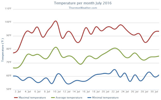
July 2016 weather recap: Thornton sees near normal temps, below average precipitation
While the month of July seemed hot and dry, statistics show that only one of those two conditions held true. We definitely saw a big time lack of precipitation but temperatures averaged out to near normal.
High pressure was the dominate feature for the month leading to overall dry conditions. We started out cooler than normal and somewhat wet for the first two days of the month. That however changed quickly.
From the 3rd through the 17th of the month, Thornton saw temperatures largely remain above normal. Only two days during that period saw precipitation and both were minimal amounts. We saw our hottest temperature of the year to date and our only 100-degree temperature reading of the year on the 10th when the mercury topped out at 100.4 Degrees.
On the 14th and 15th of the month, we had a brief respite from the heat as temperatures were a bit below normal. However, we then put together a string of 12 straight days of 90 degree or hotter readings.
The 28th and 29th then broke the streak with temperatures in the mid to upper 80s. The month then closed with two days of above normal readings.
Thornton’s overall average temperature for the month came in at 74.7 degrees. This is just above the long term Denver average for July of 74.2 degrees. Out at DIA where the Mile High City’s official measurements are taken, the average for this July was much higher at 76.2 degrees.
Temperatures in Thornton ranged from the aforementioned 100.4 degrees on the 10th down to a low of 54.6 degrees on the morning of the 9th. Denver’s official high for the month was 102 degrees on the 10th and its low of 51 degrees came on the 12th.
In terms of precipitation, Denver averages 2.16 inches during the July. Thornton fell far short of that with a paltry 0.55 inches of rain in our bucket. The airport, while receiving nearly double our total at 1.09 inches, was well short of average as well.
Click here to view Thornton’s July 2016 climate report.

From the National Weather Service:
CLIMATE REPORT
NATIONAL WEATHER SERVICE DENVER/BOULDER CO
235 AM MDT MON AUG 1 2016

...................................

...THE DENVER CO CLIMATE SUMMARY FOR THE MONTH OF JULY 2016...

CLIMATE NORMAL PERIOD 1981 TO 2010
CLIMATE RECORD PERIOD 1872 TO 2016

WEATHER         OBSERVED          NORMAL  DEPART  LAST YEAR`S
                 VALUE   DATE(S)  VALUE   FROM    VALUE  DATE(S)
                                          NORMAL
................................................................
TEMPERATURE (F)
RECORD
 HIGH             105   07/20/2005
 LOW               42   07/04/1903
                        07/31/1873
HIGHEST           102   07/10         M      -3       97  07/27
LOWEST             51   07/12         M       9       52  07/28
AVG. MAXIMUM     92.0              89.4     2.6     87.6
AVG. MINIMUM     60.5              58.9     1.6     57.9
MEAN             76.2              74.2     2.0     72.8
DAYS MAX >= 90     22              16.0     6.0       16
DAYS MAX <= 32      0               0.0     0.0        0
DAYS MIN <= 32      0               0.0     0.0        0
DAYS MIN <= 0       0               0.0     0.0        0

PRECIPITATION (INCHES)
RECORD
 MAXIMUM         6.41   1965
 MINIMUM         0.01   1901
TOTALS           1.07              2.16   -1.09     1.06
DAILY AVG.       0.03              0.07   -0.04     0.03
DAYS >= .01         6               8.3    -2.3       12
DAYS >= .10         4               4.3    -0.3        3
DAYS >= .50         1               1.4    -0.4        0
DAYS >= 1.00        0               0.7    -0.7        0
GREATEST
 24 HR. TOTAL    0.61   07/01 TO 07/01           07/18 TO 07/18
                        06/30 TO 07/01                    07/29 TO 07/29
                        07/01 TO 07/01                    07/29 TO 07/29
 STORM TOTAL       MM                                 MM
 (MM/DD(HH))            MM                    07/18(00) TO 07/18(00)
                                                 07/29(00) TO 07/29(00)9
                                                 07/29(00) TO 07/29(00)9

SNOWFALL (INCHES)
RECORDS
 TOTAL             MM   MM
TOTALS            0.0               0.0

DEGREE_DAYS
HEATING TOTAL       0                 6      -6        5
 SINCE 7/1          0                 6      -6        5
COOLING TOTAL     356               289      67      251
 SINCE 1/1        544               444     100      409

FREEZE DATES
RECORD
 EARLIEST     09/08/1962
 LATEST       06/08/2007
EARLIEST                        10/07
LATEST                          05/05
..........................................................

WIND (MPH)
AVERAGE WIND SPEED              10.2
RESULTANT WIND SPEED/DIRECTION   3/169
HIGHEST WIND SPEED/DIRECTION    54/340    DATE  07/24
HIGHEST GUST SPEED/DIRECTION    74/340    DATE  07/24

SKY COVER
POSSIBLE SUNSHINE (PERCENT)   MM
AVERAGE SKY COVER           0.50
NUMBER OF DAYS FAIR           10
NUMBER OF DAYS PC             19
NUMBER OF DAYS CLOUDY          2

AVERAGE RH (PERCENT)     46

WEATHER CONDITIONS. NUMBER OF DAYS WITH
THUNDERSTORM             12     MIXED PRECIP               0
HEAVY RAIN                1     RAIN                       0
LIGHT RAIN               13     FREEZING RAIN              0
LT FREEZING RAIN          0     HAIL                       0
HEAVY SNOW                0     SNOW                       0
LIGHT SNOW                0     SLEET                      0
FOG                       3     FOG W/VIS <= 1/4 MILE      0
HAZE                      1

-  INDICATES NEGATIVE NUMBERS.
R  INDICATES RECORD WAS SET OR TIED.
MM INDICATES DATA IS MISSING.
T  INDICATES TRACE AMOUNT.
Thornton’s August preview: Temperatures cool, severe weather eases
As summer vacations wind down and families prepare to send their kids back to school in August, Colorado weather also starts to settle down. The chances for severe weather decrease markedly during August and by the end of the month daytime temperatures are dropping quite a bit as well.
Find out more about what lies ahead with Thornton’s August weather here.
