June 5, 2016 – A stunning Thornton sunset. (Shawn Jones)
The month of June typically sees springtime severe weather reach its height of activity in northeastern Colorado.
This affords the opportunity to capture extraordinary images of amazing weather phenomena from monstrous supercell thunderstorms to heavy rain, hail and even tornadoes.
Slideshow updated June 30, 2016
Showcasing images captured by ThorntonWeather.com readers as well as some of our own, our monthly slideshow covers the entire gamut of weather and nature related imagery.
Sunsets, sunrises, wildlife and of course every type of weather condition are vividly depicted. June brings some very dynamic weather and the photos are a great way to see the stunning variety.
To learn more about how to send your photo to us for inclusion in the slideshow, see below the slideshow.
[flickr_set id=”72157668976345302″]
What is missing in the slideshow above? Your photo!
Our monthly photo slideshow is going to feature images that we have taken but more importantly images that you have captured. The photos can be of anything even remotely weather-related.
Landscapes, current conditions, wildlife, pets, kids. Whimsical, newsy, artsy. Taken at the zoo, some other area attraction, a local park, a national park or your backyard. You name it, we want to see and share it!
Images can be taken in Thornton, Denver or anywhere across the extraordinary Centennial State. We’ll even take some from out of state if we can tie it to Colorado somehow.
We’ll keep the criteria very open to interpretation with just about any image eligible to be shown in our slideshows.
What do you win for having your image in our slideshow? We are just a ‘mom and pop’ outfit and make no money from our site so we really don’t have the means to provide prizes. However you will have our undying gratitude and the satisfaction that your images are shared on the most popular website in Thornton.
To share you images with us and get them included in the slideshow just email them to us or share them with ThorntonWeather.com on any of the various social media outlets. Links are provided below.
June 26 to July 2: This Week in Denver Weather History
Our look back at this week in Denver weather history certainly has plenty of the usual suspects related to severe weather. Most notable however are the many occurrences of lightning strikes and the effects they can have from sparking fires to causing significant injury and death.
From the National Weather Service:
25-26
In 1969…high winds raked Boulder causing one fatality and some injuries. One man was injured by a falling tree limb. At the National Center for Atmospheric Research in Boulder… Sustained winds of 55 to 60 mph with wind gusts to 123 mph were recorded. In downtown Boulder…winds averaged 30 to 40 mph with gusts to 70 mph. Widespread minor damage occurred… Especially in the Table Mesa area of south Boulder. Much tree damage occurred in the older areas of Boulder where several trees were uprooted. A mobile home was overturned by the winds. At Stapleton Airport…west winds gusted to 43 mph on the 25th and 37 mph on the 26th.
In 1975…strong winds damaged utility lines…buildings… vehicles…trees…and power lines in Boulder and other communities to the north of Boulder. Microburst winds gusted to 45 mph at Stapleton International Airport on the 25th.
In 1983…heavy rain fell in the foothills west of Denver with 1.50 inches in 30 minutes at Intercanyon. Heavy rain continued over metro Denver on the 26th with two-day storm totals at many locations ranging from 1.00 to 2.50 inches. Rainfall totaled 1.37 inches at Stapleton International Airport on the 26th.
In 1985…one to two inches of rain fell over metro Denver. At Stapleton International Airport…rainfall totaled 0.93 inches…thunderstorm winds gusted to 44 mph…and 7/10 inch hail was measured. The air mass was unusually cold for the season…and snow fell in the foothills above 8 thousand feet. The high temperature of only 63 degrees on the 26th equaled the record low maximum reading for the date.
26
In 1873…there was a great deal of smoke from a large forest fire in the mountains to the southwest of the city and a smaller fire directly to the west.
In 1874…fires at timberline to the west were visible from the city. New and extensive fires were continually started from south to northwest along the ridge line. Carelessness of tourists was the apparent cause of the fires. Large and valuable tracts of timber had already been destroyed.
In 1890…the only thunderstorm of the month produced a trace of rain. A trace of rain also fell on 7 other days. This was the only precipitation recorded during the month… Making it the driest June on record.
In 1893…northwest winds were sustained to 45 mph with gusts to 48 mph.
In 1971…a microburst wind gust to 58 mph was recorded at Stapleton International Airport. Dust devils were sighted.
In 1980…strong gusty thunderstorm winds damaged several mobile homes in Thornton. Thunderstorm winds gusted to 37 mph at Stapleton International Airport.
In 1986…hail piled up 1 1/2 inches deep in Golden Gate Canyon and covered roadways an inch deep in Evergreen.
In 1988…a tornado touched down 2 miles north of Watkins. It was on the ground for 15 minutes and did no reported damage.
In 1989…two inch diameter hail fell at Kassler…1 inch hail at Louviers…and 1 1/2 inch hail at tiny town.
In 1991…high winds…not associated with thunderstorms… Damaged a home in the Green Mountain area. The strong winds picked up a heavy metal and glass table on the deck of a house and threw it into the house. The table was destroyed and the house received considerable damage.
In 1992…3/4 inch diameter hail fell in south Aurora and near Buckley Air National Guard base. Golf ball size hail was reported in Parker.
In 1994…the all-time highest recorded temperature in June and the second highest temperature ever recorded in Denver… 104 degrees occurred. This was the hottest day in Denver since August 8…1878…when the temperature reached 105 degrees.
In 2005…strong thunderstorm winds gusting to 58 mph damaged a garage and some nearby trees near Fort Lupton. Winds also gusted to 58 mph near Watkins. Thunderstorm winds gusted to 60 mph near Roggen. Hail to 3/4 inch in diameter was measured in southwest Aurora.
In 2009…severe thunderstorms moving through Denver and the surrounding metro area produced intense thunderstorm winds. At Denver International Airport…a wind gust blew a luggage car into a southwest airlines airplane causing some damage. Peak wind gusts included: 68 mph at Denver International Airport…4 miles west of rocky mountain metropolitan airport and 12.5 miles north of Lowry AFB; 64 mph near Arvada and Parker; and 60 mph in Aurora/cherry.
26-27
In 1965…wind gusts to 38 mph were recorded in downtown Boulder…causing widespread minor damage. A microburst wind gust to 41 mph was recorded at Stapleton International Airport.
27
In 1873…Pikes Peak was hidden from view by smoke from forest fires in the mountains to the southwest of the city.
In 1927…the temperature cooled to a low of only 72 degrees… The all-time record high minimum for the month.
In 1980…lightning injured 4 people on a baseball diamond in Broomfield. The bolt seriously injured the pitcher while also striking (out) the batter…catcher and second baseman.
In 1987…a microburst wind gust to 53 mph was recorded at Stapleton International Airport.
In 1990…the temperature reached a high of 102 degrees… Setting a new record maximum for the date.
In 1993…thunderstorm winds gusted to 60 mph across parts of metro Denver. A wind gust to 50 mph blew over a 30-foot canvas tent at an amusement park southeast of Denver. Fifteen people…mostly children…were injured. Microburst wind gusts to 33 mph were recorded at Stapleton International Airport.
In 2002…heavy rain…up to 3/4 inch…fell across sections of the Hayman burn area near Cheeseman Reservoir. Several forest service roads were washed out and many culverts were plugged by debris.
In 2004…heavy rain producing thunderstorms caused rock and mud slides across the overland fire burn area in Jamestown. An estimated 50 tons of sand…dirt…rock…and ash slid into town…filling a culvert under main street. The slide covered 150 to 225 feet of main street. The flood was produced by half an inch of rain in 30 minutes. A deluge of very heavy rainfall from nearly stationary thunderstorms caused flooding and flash flooding problems over parts of Jefferson and Douglas counties. An automated rain gage in Golden measured 3.60 inches of rainfall in one hour. Numerous homes were flooded in Golden…including one that was 146 years old. The home was listed as a complete loss. State Highway 93 had to be closed from the Pine Ridge subdivision to the Golden Gate Canyon Road. At the height of the storm…about 4 feet of water covered State Highway 93 through Golden… Forcing its temporary closure. Several intersections were also flooded and impassable. Rock and mud slides were reported in Golden Gate Canyon state park. At the Deer Creek Golf Course at Colorado 470 and Kipling…the greens were completely inundated by floodwaters. Some backyards near the golf course were partially washed out. In Douglas County…water up to a foot deep covered the roadways in Roxborough State Park. The Waterton Canyon Road also had to be closed due to high water.
In 2010…a severe thunderstorm produced hail up to 1 inch in diameter near Strasburg. Hail up to 3/4 inch in diameter was reported in Aurora and Buckley Air Field.
28
In 1873…there was a great deal of smoke over the city from forest fires in the mountains.
In 1875…smoke from forest fires in the foothills south of Denver were visible from the city.
In 1913…an apparent dry microburst produced southwest winds sustained to 44 mph with gusts to 48 mph in the city.
In 1925…a thunderstorm produced north winds sustained to 38 mph with gusts to 44 mph.
In 1958…a microburst caused a brief wind gust to 58 mph at Stapleton Airport.
In 1964…lightning struck several homes in metro Denver… Sparking fires. Some flooding occurred in the stockyards area…at west 45th avenue and St. Paul Street…and along Harvard Gulch.
In 1997…strong microburst winds of unknown speed downed several trees…signs…and at least one light pole in the Fort Lupton area. Two trees knocked over by the storm downed power lines causing scattered outages.
In 2002…a thunderstorm wind gust to 60 mph was recorded in Parker.
In 2005…severe thunderstorms produced wind gusts to 66 mph near Longmont and to 60 mph near Niwot. No damage was reported. A thunderstorm produced a wind gust to 55 mph at Denver International Airport during the afternoon. Continue reading June 26 to July 2: This Week in Denver Weather History→
June 19 to June 25: This Week in Denver Weather History
Heavy rain, flooding, lightning, tornadoes and hail are not at all uncommon this time of year and we see plenty of those types of events in our look back at this week in Denver weather history. Probably one of the most notable events occurred 10 years ago when a thunderstorms with large hail ripped through Denver International Airport causing $10 million in property damage and damaged dozens of airplanes.
From the National Weather Service:
19
In 1874…during the afternoon… Large columns of smoke from extensive fires in the mountain forests moved over the city from the west and southwest.
In 1875…while no precipitation was measured in the city… Rainfall over the Palmer Divide caused Cherry Creek to rise to the highest level in 10 years.
In 1977…hail up to 2 inch diameter damaged two patrol cars in Castle Rock.
In 1983 golf ball size hail fell just north of Bennett.
In 1990…lightning from a thunderstorm struck the roof of a house in south Boulder. Residents of the house were able to extinguish the ensuing fire with a garden hose…but not before several shingles had burned.
In 1992…thunderstorms produced hail up to 2 inches in diameter in central Douglas County near Castle Rock. Hail was 3 inches deep on I-25 south of Castle Rock. A funnel cloud was sighted near Parker.
In 1997…a 66-year-old man was knocked unconscious by a bolt of lightning while he was golfing at the eagle country club in Broomfield.
In 2000…dry microburst winds gusting to near 70 mph were reported across southeast Boulder and northern Jefferson counties. Peak wind gusts included: 68 mph at the national wind technology center…67 mph at Jefferson County airport… And 65 mph in Broomfield.
In 2001…severe thunderstorms produced large hail in the foothills southwest of Denver. Hail as large as 1 3/4 inch in diameter fell near conifer and Bailey.
In 2002…lightning damaged the Evergreen fire protection district radio repeater. One microwave transmitter…the main fire channel transmitter…and two solar panel controllers were destroyed. Lightning struck a garage and caused a small fire. Two vehicles parked in the garage were damaged. Hail to 3/4 inch in diameter fell near Castle Rock.
In 2004…severe thunderstorms produced hail to 3/4 inch in diameter near Castle Rock…Larkspur… And Golden.
19-21
In 1875…smoke from several large forest fires in the mountains was visible from the city on each of these days.
20
In 1888…northwest winds were sustained to 44 mph.
In 1956…a microburst caused a brief wind gust to 58 mph at Stapleton Airport.
In 1964…hail up to 1 inch in diameter was reported 1 mile north of Stapleton International Airport. A 3 minute hail storm at both Stapleton International Airport and lowry field piled small hail to one half inch deep.
In 1967…a strong thunderstorm dumped 1.95 inches of rain in less than an hour at Stapleton International Airport and produced a wind gust to 54 mph. The storm caused some flooding in east Denver and Aurora. There was widespread flooding to streets…basements… And store buildings and automobiles. Hail stones to 3/4 inch in diameter were measured at Buckley Field in Aurora. A tornado touched down just south of Littleton…damaging a barn and killing several head of cattle.
In 1985…a wind gust to 61 mph was reported at Golden Gate Canyon in the foothills west of Denver.
In 1986…a man was killed by lightning at Highlands Ranch south of Denver.
In 1987…several tornadoes were sighted across metro Denver. A tornado touched down briefly 5 miles west of Parker. A tornado was sighted just north of Chatfield Reservoir. A tornado just northwest of Watkins was on the ground for 15 minutes. A tornado near Barr Lake was taped by a television news crew. It had a double vortex and was on the ground for about 10 minutes. In addition to the 4 tornadoes…severe thunderstorms dumped large hail across metro Denver. One inch hail was reported in southeast Aurora; 3/4 inch hail fell at the Denver Technology Center…Buckley Field… And Franktown.
In 1992…several short-lived tornadoes occurred in the vicinity of Barr Lake. No injuries or damages were reported. A water spout was sighted over the southern end of Barr Lake. Funnel clouds were also sighted on the grounds of the rocky mountain arsenal by national weather service observers at Stapleton International Airport.
In 1994…hail up to dime size covered I-25 south of Denver and near Sedalia. Heavy rain caused local flooding on the interstate Highway.
In 1996…strong thunderstorm winds downed several large tree limbs in Boulder on the University of Colorado campus. A stop light in the city was also blown down.
In 1999…lightning sparked an oil tank fire near Brighton.
In 2001…large hail driven by strong thunderstorm winds raked Denver International and Front Range airports. Wind gusting to 54 mph along with hail as large 2 inches in diameter punched at least 14 thousand holes and cracks in the flat roofs of several buildings at Denver International Airport. In addition…93 planes and hundreds of cars were damaged. About 100 flights had to be cancelled…stranding 1500 travelers. The airport was completely shut down for about 20 minutes. The storm also damaged a ground avoidance radar used to track planes on the ground to prevent collisions. Damage was estimated at 10 million dollars…not counting the damage to the 93 airliners. The storm moved south and struck Watkins with hail as large as 2 1/2 inches in diameter and winds gusting to 60 mph. A least 30 private planes at Front Range airport were destroyed. The radome protecting the National Weather Service Doppler radar…which was tracking the storm…also sustained damage. The large hail…damaging winds… And heavy rain pummeled a mobile home park near Watkins. In the park…52 mobile homes… 14 recreational vehicles…3 homes… And a commercial building were damaged. Siding was riddled with holes and windows were broken. Vehicles sustained extensive damage and car windows were shattered. A handful of people were treated for minor cuts and bruises. The strong winds also flipped a tractor trailer along I-70 near Watkins. The storm caused power outages…which affected about 1200 residents. Excluding the damage at Denver International Airport…damage estimates totaled 49 million dollars…making the storm the costliest in the last 3 years and the 10th costliest since 1984. A small tornado touched down just east of Brighton… But did no damage. Hail as large as 2 inches in diameter fell near Fort Lupton with 3/4 inch hail measured in Bennett. Precipitation from the storm totaled only 0.23 inch at Denver International Airport.
In 2002…heavy rain fell near the Hayman wildfire burn area. Flash flooding washed out a 40-foot section of the access road to Cheeseman Reservoir. Some debris was washed against a gate…blocking the road. Hail to 1 1/2 inches in diameter fell near central city with 3/4 inch hail near Blackhawk.
In 2003…hail as large as 1 inch in diameter fell near Bennett and Strasburg with 3/4 inch hail measured in Denver…Golden… At Centennial Airport…and near Parker. Hail as large as 7/8 inch was reported in Arvada.
In 2004…a severe thunderstorm produced hail to 3/4 inch in diameter in and near Brighton.
In 2005…severe thunderstorms produced large hail near the palmer divide. Hail to 1 inch in diameter was measured near larkspur with 7/8 inch hail near Sedalia and 3/4 inch hail in Greenland. An apparent thunderstorm outflow produced a wind gust to 59 mph at Denver International Airport during the evening hours.
20-21
In 1897…high winds raked the city overnight. Southeast winds were sustained to 60 mph with gusts as high as 72 mph on the 20th. Southeast winds were sustained to 57 mph with gusts to 60 mph on the 21st.
In 2007…a brief hot spell produced two temperature records. The high temperature of 97 degrees was tied on the 20th. A new record high temperature of 99 degrees was established on the 21st.
June 12 to June 18: This week in Denver weather history
The first half of June is when Colorado’s severe weather season really kicks into high gear and our look back at this week in Denver weather history reflects that. Numerous flooding, hail, and tornadic events punctuate just how dangerous and damaging our weather can be this time of year.
From the National Weather Service:
11-14
In 1999…damage from several hailstorms in and near metro Denver totaled 35 million dollars. About 17.5 million dollars was from automobile claims with another 17.5 million in homeowner claims. The areas hardest hit by the storms included Castle Rock…Commerce City…Evergreen… And Golden.
12
In 1901…south winds were sustained to 45 mph with an extreme velocity to 47 mph.
In 1917…northwest winds were sustained to 40 mph with gusts to 45 mph.
In 1927…flooding on Little Dry Creek in Englewood resulted in two deaths.
In 1947…a trace of snow fell over downtown Denver during the early morning. This was the latest last snow of the season (trace or more). This also marked the end of the longest snow season…264 days…from the first snow…a trace…on September 22…1946. High temperature of 43 degrees was a record low maximum for the date. Minimum temperature of 33 degrees was a record low for the date.
In 1971…a funnel cloud sighted over Arvada possibly touched down at the base of the foothills. The public reported 3/4 inch to 1 inch diameter hail over the city of Denver.
In 1974…strong thunderstorm winds caused damage to power lines in metro Denver. Northwest winds gusted to 45 mph at Stapleton International Airport.
In 1975…a thunderstorm wind gust to 56 mph was recorded at Stapleton International Airport.
In 1982…three small tornadoes were sighted near Bennett. One of the twisters caused minor crop and road damage along its path. A brief tornado was sighted by national weather service observers at Stapleton International Airport.
In 1983…3/4 inch hail fell in Boulder. Golf ball to 3/4 inch size hail fell in Arvada…denting cars and house roofs. Over a thousand hail damage insurance claims were filed from the area. Golf ball size hail also fell in Northglenn and Bennett…1 to 2 inch hail in Thornton…2 1/2 inch hail in northeast of Denver. A tornado was sighted 10 miles northeast of Stapleton International Airport; it was only on the ground for 1 to 2 minutes.
In 1984…large hail pelted many parts of southern metro Denver. Fifteen aircraft were damaged by golf ball size hail at Centennial airport. Golf ball size hail was reported in south Denver…and 3/4 inch hail was measured in southeast Aurora.
In 1987…a small weak tornado touched down for about 3 minutes near the intersection of I-70 and Colorado Blvd in northeast Denver. No damage was recorded. A microburst wind gust to 53 mph was recorded at Stapleton International Airport.
In 1991…in the city of Denver…lightning struck a tree under which seven people were picnicking. One person was critically injured. The others received only minor injuries.
In 1992…golf ball size hail fell in Evergreen.
In 1994…microburst winds gusting to 53 mph kicked up some blowing dust at Stapleton International Airport.
In 1996…lightning struck a house in Parker…which sparked a fire. The bolt was strong enough to blow nails out of the drywall in one room. About 85 percent of the house was damaged. No dollar estimate of the damage was available. Lightning also struck a power line in Boulder…which left 250 customers without electricity for a short time.
In 1997…a tornado touched down near Parker…damaging some construction equipment. Hail to 2 inches in diameter was measured in Henderson. One inch diameter hail fell in the city of Denver with 3/4 inch hail measured in Lakewood.
In 1999…hail as large as 1 1/2 inches in diameter struck Hudson. A funnel cloud was sighted by ramp personnel to the east of Denver International Airport.
In 2003…lightning blew a hole in the roof of a house in Highlands Ranch. The bolt knocked several holes in the bedroom ceiling and damaged the home’s electrical system.
In 2004…lightning struck a home in Louisville…but caused only minor damage.
In 2006…a strong microburst wind gust…estimated at 69 mph… Ripped the roof off a horse barn near the intersection of Havana Street and Smith Road in Denver. A 13 year old girl was injured…when she was thrown from a horse inside the barn at the time the roof was being torn off. A thunderstorm produced a microburst wind gust to 54 mph and a trace of rainfall at Denver International Airport. A severe thunderstorm produced hail to 0.75 inch near Watkins.
12-17
In 2000…two large wildfires developed in the Front Range foothills as careless campers and very dry conditions proved to be a dangerous combination. Strong winds gusting in excess of 60 mph on the 13th fanned the flames… Spreading both wildfires out of control. Winds gusted to 78 mph atop Niwot Ridge near the Continental Divide west of Boulder. The Hi Meadows wildfire…about 35 miles southwest of Denver…consumed nearly 11 thousand acres and 80 structures…mostly high priced homes. The Bobcat wildfire…located about 12 miles southwest of Fort Collins… Consumed nearly 11 thousand acres and 22 structures. Late on the 16th…a strong cold front moved south over the great plains into northeastern Colorado. Low level upslope conditions developed in the wake of the front…producing 2 to 4 inches of snowfall overnight at elevations above 8 thousand feet. Firefighters were able to contain both fires shortly thereafter.
13
In 1956…a microburst caused a brief wind gust to 59 mph at Stapleton Airport.
In 1957…an unconfirmed tornado appeared to touch the ground in the vicinity of Franktown. No damage was reported from the twister.
In 1968…a violent gust of wind…possibly associated with a thunderstorm…caused 75 hundred dollars damage in Boulder.
In 1973…hail…1/2 to 3/4 inch in diameter…fell over Lakewood. Flash flooding occurred in west Denver from the same storm.
In 1974…a thunderstorm wind gust to 64 mph was recorded at Stapleton International Airport.
In 1977…hail the size of table tennis balls…1 1/2 inches in diameter…was reported in Boulder.
In 1981…large hail to golf ball size fell in Denver… Northglenn…and Brighton. Hail as large as baseballs was reported in federal heights.
In 1984…one of the worst hailstorms ever experienced in metro Denver struck the northwestern suburbs of Arvada…Wheat Ridge…and Lakewood…but large hail also fell in Golden… Southeast Denver…and Aurora. Homes and other buildings sustained around 200 million dollars in damage. Thousands of cars were battered by giant hailstones…and total damage to vehicles was estimated at 150 million dollars. In some areas…golf ball size hail fell continuously for 30 to 40 minutes. Some places were pelted with a few stones as large as grapefruits! Roofs on thousands of structures were severely damaged. Uncounted car windshields were broken; two-thirds of Arvada’s police cars were rendered inoperable. Torrential rains…with as much as 4.75 inches in Lakewood clogged drains and caused widespread damage from flooding. In some places hail was washed into drifts several feet deep. About 20 people were injured by the giant hailstones. One couple was hospitalized. A woman drowned when she was trapped under a trailer by high water. Only pea size hail fell at Stapleton International Airport.
In 1988…2 inch hail fell in Parker. Soft hail 1 inch in diameter fell at the mouth of turkey creek canyon 5 miles southeast of Morrison. Hail between 1 inch and 1 3/4 inches fell at both Bennett and Strasburg. A tornado touched down briefly at Strasburg. A brief funnel cloud was sighted by national weather service observers 15 miles southwest of Stapleton International Airport.
In 1991…a Boulder man was injured when struck by lightning while in a tent. He received only minor burns.
In 1997…lightning struck a home in Denver. The extent of the damage was unknown. A home in Littleton was also struck. The house caught fire…but the extent of the damage was not known.
In 1998…a strong mountain wave produced a brief period of high winds along the Front Range. A small building atop squaw pass west of Denver was blown down. Tree limbs were downed across metro Denver. Peak wind gusts included: 80 mph on Squaw Pass…69 mph at Jefferson County Airport near Broomfield…and 60 mph in Westminster and at the National Center for Atmospheric Research in Boulder. West-northwest winds gusted to 51 mph at Denver International Airport.
In 2001…high winds developed briefly in Boulder County. A peak wind gust to 76 mph was recorded at the National Center for Atmospheric Research atop the mesa in Boulder. A wind gust to 72 mph was recorded at southern hills middle school in Boulder. Lightning started a small fire…which damaged the roof of a house in Greenwood Village.
In 2009…severe thunderstorms produced hail up to one inch in diameter near Arvada and byers…as well as 7 miles north-northwest of Front Range airport near watkins.
13-14
In 2006…the high temperature of 99 degrees on the 13th equaled the record maximum temperature for the date first set in 1994. The high temperature of 102 degrees on the 14th was a new record maximum temperature for the date.
14
In 1877…an evening thunderstorm produced lightning which struck several houses and killed a cow in the bottom land of the South Platte River
In 1886…hail as large as 3/4 inch in diameter fell in the city. Precipitation was only 0.10 inch.
In 1887…south winds were sustained to 41 mph.
In 1900…a thunderstorm produced northwest winds to 51 mph with gusts to 61 mph…but only a trace of rain.
In 1923…a severe thunderstorm pelted the city with hail. The stones ranged in diameter from 0.2 to 0.8 inch. Gardens and greenhouses suffered considerable damage. Rainfall was only 0.14 inch downtown.
In 1960…one workman was killed and 4 others injured in Lakewood when a partly built apartment building collapsed in strong winds. Microburst wind gusts to 54 mph caused some blowing dust at Stapleton Airport.
In 1967…tornadoes touched down briefly 3 miles west of Franktown and 4 miles northeast of Parker. No damage was reported. Numerous funnel clouds were reported over south metro Denver…one 5 miles south of Denver…one 2 to 3 miles north of Castle Rock…and two near Littleton.
In 1968…a microburst wind gust to 52 mph was recorded at Stapleton International Airport.
In 1972…1 3/4 inch hail was reported in Wheat Ridge.
In 1976…high winds…unusually strong for this late in the season…raked metro Denver. Wind gusts estimated to 100 mph tore 24 boats from their moorings and damaged a total of 47 boats at Boulder reservoir. Wind gusts to 82 mph were recorded in Boulder. The strong winds toppled the wind mast at a radio station in Boulder. An automobile was smashed by a fallen tree in Boulder. Other damage in Boulder was minor…but power outages occurred when tree limbs fell on power lines. At Jefferson County Airport near Broomfield…wind gusts to 78 mph were recorded with 87 mph gusts clocked at Rocky Flats nuclear plant south of Boulder. Wind gusts to 66 mph were observed in Littleton… And northwest winds gusted to 46 mph at Stapleton International Airport. The strong winds collapsed a barn near Arvada. Several horses received minor injuries. Thirty trees were uprooted or broken in Denver. Four major power outages occurred from west Denver and Lakewood to the foothills.
In 1982…the worst hailstorm in 17 years struck Commerce City. The storm left 4 to 8 inches of hail on the ground. A few of the stones were as large as golf balls. Many vehicles were dented…and some windshields were shattered. Roofs of homes were damaged. Total damage was estimated at over one million dollars. Hail to 1 inch in diameter also fell in Littleton. Only 1/4 inch hail was measured at Stapleton International Airport.
In 1988…lightning ripped a small hole in the roof of a home in the southern part of Boulder. There were some power outages in the area.
In 1992…an off duty national weather service employee reported hail to 1 inch diameter in Westminster.
In 1997…one inch diameter hail fell in Bennett…and 3/4 inch hail was measured in Littleton.
In 1999…hail as large as 1 1/2 inches in diameter hit Aurora. Lightning sparked two small fires at separate residences near the Hiwan Country Club in Evergreen.
In 2004…lightning sparked two small fires near Jamestown. One was in Geer Canyon and the other 7.5 miles up Sunshine Canyon. Both were quickly contained and caused no damage to structures in the area.
In 2009…a complex of severe thunderstorm produced large hail damaging thunderstorm and funnel clouds across parts of the urban corridor. The line formed along a boundary over the western suburbs of Denver then moved east. The boundary produced at least one well defined funnel cloud that could be observed by stadium full of baseball fans at Coors Field. Large hail…up to 1 3/4 inches in diameter…was reported in Arvada…Broomfield…Denver…Federal Heights and Northglenn. In addition…the storm produced peak wind gusts from 60 to 74 mph. At Denver International Airport…a peak wind gust to 58 mph was observed from the west-northwest.
In 2014…severe thunderstorms broke out across the Urban corridor. Large hail…ranging in size from 1 to 2 inches in diameter…was observed. The area extended from around Englewood to Aurora and included: Brookridge…Cherry Knolls… Greenwood Village and south Denver. As many as 212 thousand residences were potentially impacted by the storms. The hail shattered windshields and damaged vehicles.
Climate models overstating case for man-made global warming, study suggests
Whenever climate models overestimate temperatures linked to rising carbon dioxide levels in the atmosphere, scientists have pointed to a convenient fall guy: aerosols, which cool the planet and act as a counterweight to global warming. But what if the cooling influence of aerosols isn’t as powerful as believed? Preliminary findings from a major study by the… Continue reading Climate models overstating case for man-made global warming, study suggests→
Thornton, Colorado monthly and seasonal snowfall totals from the 2006 / 2007 season to the the 2015 / 2016 season. Click for larger view. (ThorntonWeather.com)
To say we had a lot of snow this past season would be a bit of an understatement. Our total came in at more than 2 feet higher than historical average for Thornton and Denver.
In all, Thornton received 85.7 inches of snowfall for the 2015 / 2016 season. That total eclipses the 10-year Thornton average of 58.0 inches and Denver’s official 30-year average (1981 – 2010) of 55.3 inches.
The measurement is also Thornton’s highest snowfall total of the past 10 years since ThorntonWeather.com came into existence. The next highest seasonal total is the 72.9 inches received during the 2006 / 2007 season.
Thornton saw five months with above normal snowfall. Most notable was November which received nearly 10 inches more than normal and March with 18.9 inches more than average.
Denver’s official seasonal total was well above normal as well. Out at Denver International Airport where the measurements are taken, The National Weather Service reported 72.8 inches.
It is likely if the Mile High City’s measurements were still done at a location in the city, the total would have been a good bit higher.
Extreme weather can occur during in month in Colorado we well know. June however is when traditional spring severe weather arrives in the state oftentimes with hail, damaging wind and tornadoes.
Over 40 percent of the tornadoes that occur in Colorado happen during the month of June. Far more common are thunderstorms with hail and wind, each responsible for extensive damage each year.
While severe weather is common, so too are brilliantly sunny and mild days as we close out spring and enter summer. If you are looking for cold, it isn’t likely but it is possible as the Denver area has seen freezing temperatures and yes, even snow, during the month.
June 5 to June 11: This week in Denver weather history
The first part of June typically brings some of Denver’s most eventful weather of the year and we clearly see that in our look back at this week in Denver weather history. From many damaging hail and wind events to heavy rains that resulted in flooding and even the Southlands Mall tornado of 2009 it has been an eventful week in history.
From the National Weather Service:
1-30
In 2012…it was the hottest June in Denver since weather records began back in 1872. The average temperature for the month was 75.0 degrees which was 7.6 degrees above normal. There were a total of seventeen 90 degree days in the month of June. The highlight of record setting month was a stretch of five consecutive 100 degree days from the 22nd to the 26th. This was only the third time in Denver weather history in which this happened. Two of the high temperatures during the stretch peaked at 105 degrees…which set the all time record for the month of June and tied the all time maximum temperature for Denver.
2-7
In 1921…heavy rainfall for nearly a week…on top of streams already swollen by mountain snowmelt…produced widespread flooding over the South Platte River basin…including the tributaries through the canyons to the west and southwest of Denver. Heavy rainfall over the 6-day period totaled 3.36 inches in Boulder…4.98 inches in Morrison…4.27 inches in Castle Rock…and 2.94 inches in the city of Denver. Rainfall amounts in the foothills were estimated between 3 and 6 inches. The narrow-gage tracks of the Colorado and southern railroad were destroyed in the Platte Canyon. From the mouth of the canyon through the city to near Brighton… The river spread from 1/2 to nearly 1 1/2 miles wide… Flooding farm and pasture land and destroying or damaging many bridges. In the city…many businesses along with as many as 500 homes were inundated…forcing their evacuation. Bridges were swept away. The high waters flooded the rail yards and stock yards in lower downtown…closing three adjacent packing houses. The heavy rains also caused flooding on Boulder creek in Boulder on the 6th.
4-5
In 1965…lightning and an 18-hour rain storm damaged streets and roads and telephone and power lines across metro Denver. Precipitation totaled 2.77 inches at Stapleton International Airport where the visibility was reduced to 3 miles at times from pre-frontal thunderstorms and heavy upslope rains.
In 1998…a late season snow storm struck the Front Range foothills. Up to 5 inches of snow fell in Coal Creek Canyon. Light snow also fell over western sections of metro Denver and briefly at Denver International Airport. Snow covered the grass at the Denver federal center in Lakewood before melting around mid-morning on the 5th. No snow fell at the site of the former Stapleton International Airport. Several temperature records were set. High temperatures of 47 degrees on the 4th and 49 degrees on the 5th were record low maximums for their respective dates. Minimum temperature of 34 degrees on both the 5th and 6th were record lows for those dates.
5
In 1864…high water on the west fork of clear creek caused a small dam near empire to fail…which destroyed several downstream bridges.
In 1885…a windstorm during the afternoon and early evening produced south to southwest winds at sustained speeds up to 42 mph.
In 1937…a trace of snow fell in downtown Denver. This was the latest snowfall of record at the time. Light rain and snow were mixed around mid-day. Precipitation totaled only 0.01 inch. North winds were sustained to 20 mph.
In 1941…hail of unknown size fell on the city.
In 1961…lightning struck and injured an airman outside a base classroom at Lowry Air Force Base. Funnel clouds were sighted near Frederick and firestone north of Denver. The one near Frederick briefly touched down in an open field but caused no damage. Heavy rain and hail hit the Fort Lupton area causing damage to crops. Heavy rain in Frederick added to the flood damage of the 3rd. A pilot reported a funnel cloud that touched down briefly and then dissipated south of Castle Rock.
In 1965…a lightning-caused fire destroyed a mountain home near Rollinsville.
In 1988…a tornado touched down 5 miles east of Lafayette near I-25 and stayed on the ground for 15 minutes. The twister hit a campground…demolishing one trailer and damaging six others…along with 4 cars. The rope-like funnel also blew down fences…signs…and electrical boxes. The twister moved a 1500-pound hay wagon 150 feet. Total damage to the campground was estimated at 50 thousand dollars. Another tornado touched down between Broomfield and Lafayette…staying on the ground for about 20 minutes. The twister hit a subdivision…unroofing one abandoned house and causing minor damage to a dozen others. A four- car garage and three barns were destroyed. At one location a chain link fence…a satellite dish…and a shed were destroyed…while the deck and garage of the house were damaged. A grain storage tank was moved 200 feet. There were reports of boards being blown through walls; one came through a kitchen.
In 1992…lightning struck a 15-year-old boy…causing minor injuries…in Adams County 6 miles north-northeast of Stapleton International Airport. Thunderstorm winds gusted to 63 mph at Jefferson County Airport near Broomfield…to 58 mph at the U.S. Atomic Energy Commission’s facility at Rocky Flats…to 58 mph in Thornton…and to 48 mph at Stapleton International Airport where 1/8 inch diameter hail fell.
In 1996…strong microburst winds up to 60 mph damaged several trees in Boulder…snapping large branches 1 to 2 inches in diameter.
In 1997…a woman was struck by lightning as she was walking to her car in Nederland. The lightning bolt apparently struck a nearby power line and arced into her left hand. She received minor injuries.
In 2014…severe thunderstorms broke out across parts of Arapahoe…Douglas…Elbert and Jefferson Counties… impacting areas generally southwest and south of Denver. The storms produced large hail…from quarter to golfball size.
5-6
In 1977…lightning caused several power outages and moderate damage to a railroad building.
6
In 1954…thunderstorm winds at speeds of 50 mph with gusts as high as 59 mph briefly reduced the visibility to 1 mile in blowing dust at Stapleton Airport.
In 1967…the public reported golf ball to 1 3/4 inch diameter hail in the city…3 miles west-southwest of Stapleton International Airport. The amount of damage was unknown. Thunderstorm winds gusted to 46 mph at Stapleton International Airport.
In 1981…hail to 3/4 inch in diameter was reported in east Denver.
In 1990…golf ball size hail was reported near Strasburg on I-70 east of Denver.
In 1991…a tornado was spotted by national weather service personnel and weather spotters…14 to 17 miles northeast of Stapleton International Airport. A funnel cloud was sighted over south Aurora just east of Buckley Field…and a tornado was spotted just east of Watkins. No damage was reported. Thunderstorms moved through Aurora and dropped hail up to 1 inch in diameter. The storms also produced heavy rain… Up to 1 inch in 30 minutes…causing flooding of streets. Water was reported hood deep…stranding motorists. Water covered fire hydrants at some intersections.
In 1995…a waterspout sighted over Standley Lake in northern Jefferson County…quickly dissipated once it reached shore. A brief tornado…which was momentarily visible by a dust debris cloud on the ground…damaged the roof of a house in Westminster. A funnel cloud was sighted just south of Lafayette. Hail from 3/4 to 1 1/4 inches in diameter fell over north Boulder. Thunderstorm outflow produced north wind gusts to 44 mph at Denver International Airport.
In 1997…a tornado touched down near baseline reservoir just east of Boulder. The tornado struck a home…tearing off part of the roof. A storage building nearby was nearly leveled and 5 trees were uprooted. The twister then moved onto baseline reservoir…forming a huge waterspout. Several recreational vehicles and a boat dock were also damaged. A nearly stationary line of thunderstorms dumped 4.60 inches of rain on portions of Thornton. Extensive flooding of streets and underpasses and other low lying areas was reported. Several businesses were flooded and basements in the area were damaged. Rainfall totaled 1.02 inches at Denver International Airport and 1.24 inches at the site of the former Stapleton International Airport. Large hail…up to 1 3/4 inches in diameter…fell over the city of Denver with 3/4 inch hail measured in Littleton and near Henderson.
In 1999…high winds developed for a brief time in and near the foothills of Boulder. The Gamow Tower on the University of Colorado campus recorded a wind gust to 87 mph. Winds peaked to 71 mph atop Niwot Ridge near the continental divide west of Boulder.
In 2003…a small tornado touched down near Strasburg…but did no damage.
In 2012…severe thunderstorms broke late in the evening…striking areas hardest from Denver southward. Locations impacted by the storms included but were not limited to: Aurora…Castle Rock…Centennial…Highlands Ranch…Lone Tree…Parker and Surrey Ridge. The storms produced a barrage of
large hail…damaging straight line winds…flash flooding and several short lived tornadoes. The hail ranged in size from 1 to 2 inches in diameter…and caused extensive damage to homes and automobiles. The hail inundated the roadways with several inches of hail in Douglas County. Consequently…snow plows had to be called out to clear the roadways. The combination of torrential hail and heavy rain produced flash flooding in parts of Elbert…Douglas and Arapahoe Counties…as thunderstorms brought up to 3.35 inches of rain to some areas within 90 minutes. In Aurora…Picadilly Road was closed from flooding north of 6th Avenue. A water rescue took place on South Gun Club Road in Arapahoe County…where floodwaters were rushing to depth of 3 feet. Flash flooding forced the closure of several streets and roads from Parker south to The Pinery…where the floodwaters inundated the roadway with up to 2 feet in several locations. At Centennial Airport…a historic B-17 Flying Fortress suffered extensive damage as hailstones as large as ping pong balls struck the aircraft. Although the airframe itself did not require repair…the fabric-covered ailerons and elevators were extensively damaged. The hail came straight down and punched holes in the fabric-covered control surfaces. The aircraft landed just hours before the storm hit to participate in a weekend tour stop. Lightning also struck two homes…one in Lakewood and the other in Parker. Straight line winds downed trees and power lines in Aurora.
As a result…scattered electrical outages affected around five thousand residents. At Denver International Airport…0.61 inches rainfall was recorded along with a peak wind gust of 41 mph.
6-7
In 2004…a brief hot spell produced 3 temperature records. High temperatures of 95 degrees on the 6th and 98 degrees on the 7th were record maximum temperatures for the dates. Low temperature of 68 degrees on the 7th was a record high minimum for the date.
In 2007…an unusually strong storm system brought very strong winds to the Front Range foothills and urban corridor. Peak gusts included: 92 mph at Boulder…85 mph…2 miles southwest of Boulder…83 mph…10 miles south of Boulder and 55 mph at Denver International Airport. High winds forced the closure of Mt. Evans road and Trail Ridge Road. Several trees were uprooted across the urban corridor. In Aurora… The driver of a car was injured when some building material blew off the Fitzsimmons Complex. The debris landed on the car and knocked the driver unconscious. The wind forced the cancellation of 60 flights at Denver International Airport. Xcel reported outages in Boulder…Denver…Lakewood and Longmont.
7
In 1904…a thunderstorm produced south winds to 40 mph with gusts to 50 mph…but only a trace of rain.
In 1942…heavy thunderstorm rainfall in south Denver caused flooding of shops…stalled motorists…and halted tramway service temporarily. Lightning damaged houses…but there was no loss of life. Precipitation totaled 0.53 inch in downtown Denver.
In 1951…a 24×65 foot roof of a cow barn was lifted off the building and blown to the ground by a “twister” near Fort Lupton.
In 1961…small hail and heavy rain damaged property and crops in southwest metro Denver…including the southwest section of the city…Lakewood…and Littleton. Precipitation totaled 1.20 inch…11 miles southwest of Stapleton Airport. Complete primary and secondary rainbows were sighted by national weather service observers at Stapleton Airport.
In 1968…severe thunderstorms moving to the northeast through sections of Denver caused local flooding of streets and damage to trees and gardens from hail 1/2 to 1 3/4 inches in diameter. One man was killed and 2 were injured at the Wellshire Golf Course when lightning struck a tree under which they had taken shelter. At another golf course… A man was mortally injured by lightning. Marble to golf ball size hail fell over downtown Denver. Hail to 3/4 inch in diameter was measured in Westminster.
In 1975…hail up to 3/4 inch diameter fell in Boulder.
In 1978…a man standing under a tree on a golf course in Denver was struck in the arm by lightning. Wind gusts to 60 mph and golf ball size hail pelted west and south Denver.
In 1986…7/8 inch hail was measured in Lafayette.
In 1990…a thin…rope-shaped tornado touched down east of the intersection of State Highway 2 and 96th avenue just north of the rocky mountain arsenal. No damage was reported.
In 1992…a thunderstorm wind gust to 60 mph was recorded in Boulder. A funnel cloud was sighted by a highway patrol officer just northwest of Stapleton International Airport where thunderstorm winds gusted to 51 mph. Spotters and state patrol officers reported funnel clouds in the northwestern part of metro Denver…near Golden…and 7 miles northwest of Stapleton International Airport.
In 1993…non-convective high winds pummeled the Front Range foothills during the late morning and afternoon. Speeds of 60 to 80 mph were common. The winds caused several power outages as well as uprooting trees. In Lafayette…a 4-year- old boy was slightly injured while standing on the roots of a large tree which was toppled by the winds. The boy fell 10 feet to the ground and was bruised and scraped. A tree fell onto a parked car in Boulder…causing about 35 hundred dollars in damage. West wind gusts to 41 mph were recorded at Stapleton International Airport where a thunderstorm produced 1/8 inch hail at daybreak.
In 1995…severe thunderstorms produced large hail across west and north metro Denver from Golden to Westminster and Fort Lupton. Hail ranged in size from 3/4 to 2 inches in diameter. The largest hail fell in Fort Lupton. A weak tornado produced a brief dust and debris cloud in a corn field 3 miles northeast of Hudson.
In 1997…two plumbers were injured…one critically…when lightning struck a pipe on which they were working in an apartment building under construction in Denver. The bolt apparently hit one man in the hand…passed through his chest…and struck the other worker. The critically injured man…died a few days later. Lightning also injured a man…while he was talking on a telephone in Ward. The bolt passed through the phone line burning his ear.
In 2001…hail as large as 7/8 inch in diameter fell in Westminster.
In 2009…severe thunderstorms in Denver and the surrounding metropolitan area produced five tornadoes… Large hail…up to 3 inches in diameter…and damaging thunderstorm winds. The tornado that produced the most significant damage touched down in southeast Aurora… South of Buckley Airport; it moved south-southeast across open fields…some residential areas and damaged southlands mall. It was 100 yards wide with a storm track of approximately 5 1/2 miles. Southlands Mall had some roof and window damage…as well as wall damage to one of its restaurants. South of the mall…Lowe’s received some roof damage; lightweight sheds and other structures were also destroyed. Numerous homes and apartments suffered window damage…minor roof damage and there were a few broken garage doors. One resident…north of the mall…was injured when he was swept off his porch while attempting to photograph the tornado. He was found unconscious and bleeding in his front yard…with a dislocated shoulder…an injured neck…and numerous other injuries. In addition…the tornado flipped a trailer home. A man inside the trailer suffered minor injuries. In parts of Aurora and Centennial…thunderstorm winds blew down power lines and caused electrical outages. Approximately 8000 homes and businesses were without power for nearly two hours. Earlier in the day…a tornado touched down about 6 miles northwest of Northglenn and caused minor damage. It’s path covered approximately 1/2 mile. Several trees were downed in an open field. The tornado also damaged a metal fence and caused minor roof damage to a nearby residence. The third tornado touched down 7 miles east-northeast of Buckley Air Field and flipped a semi-trailer as it passed over interstate 70. Lastly… Two tornadoes touched down in northwest Elbert County. One tornado damaged several outbuildings…a residence…and downed several trees. In addition… Several horses were injured by flying metal debris. The other tornado touched down in open country. This day was the first in the series of eight to cause damage along the urban corridor. Damage to homes and property along the Front Range totaled $161 million during the 8-day span. The majority of the property damage was caused by hail; 21000 automobile claims and 13000 homeowner claims were filed.
In 2012…severe thunderstorms brought damaging wind and hail…heavy rain and flash flooding. The storms produced hail from 1.5 to 2.5 inches in diameter. In addition to the large hail…heavy rain from 1 to 2 inches also accompanied the storms. The combination of hail and heavy rain caused extensive street flooding across Aurora…Castle Rock…Centennial…Cherry Creek…Englewood…South Denver…Highlands Ranch…Lakewood and Littleton. The hail was reportedly “knee deep” in several areas making roads impassable. As a result…snow plows had to be summoned to clear the streets. In Castle Rock…a King Soopers supermarket sustained extensive damage when roof partially collapsed under the weight of the hail. At Denver International Airport…0.61 inches of rainfall was again recorded along with a peak wind gust of 40 mph. Total property
damage estimates along the Front Range for the 6th and 7th combined was 321.1 million dollars.
7-9
In 1979…rain…at times with thunder on the 7th…fell almost continuously through the morning of the 9th. Rainfall totaled 2.28 inches at Stapleton International Airport over the 3 days. High temperature of only 49 degrees on the 8th was a record low maximum for the date.
Thornton saw overall weather conditions not too far out of line with what we expect for the month of May. Temperatures were a good bit below normal however while precipitation came in right near average.
The month started out a bit chilly and we received our first and only snow for the month on the first. Warmer weather returned right away though and lasted until the 7th of the month when severe weather arrived to the Colorado plains. Tornadoes and large hail were seen to our east and northeast but we received only a bit of rain and some small hail.
Cooler weather conditions lasted for a few days before we warmed up for two days on the 12th and 13th. That was short-lived however and once again things cooled down quite a bit with the 16th and 17th of the month seeing high temperatures only in the mid to upper 40s and a healthy shot of rain.
The final 11 days of the month saw temperatures near or above normal for the most part. Stormy weather returned on the 24th as afternoon thunderstorms brought marble sized hail to Thornton. Eastern Adams County and Washington County saw tornadoes and large, damaging hail. Six of those last 11 days of the month did bring measurable precipitation.
Thornton saw a monthly average temperature of 54.2 degrees. This was well below Denver’s 30 year average for the month of May of 57.1 degrees. Out at DIA where Denver’s official measurements are taken, the Mile High City was similarly cool with a monthly average of 54.4 degrees.
Temperatures in Thornton ranged from a high of 85.6 degrees on the 21st down to a below freezing low of 24.9 degrees on the 2nd. Out at the airport, the warmest reading was 83 degrees and the lowest 28 degrees, both on the same dates as our warmest / coldest temperatures.
In terms of precipitation, Denver averages 2.12 inches during the month of May. Thornton saw 2.07 inches in our rain bucket while DIA recorded 2.38 inches.
The only snow during May 2016 in Thornton came on the first of the month when 0.3 inches fell. Denver officially recorded only a trace. Average snowfall for the month of May in Denver is 1.1 inches.
May 2016 temperature summary for Thornton, Colorado. (ThorntonWeather.com)May 2016 precipitation summary for Thornton, Colorado. (ThorntonWeather.com)
From the National Weather Service:
CLIMATE REPORT
NATIONAL WEATHER SERVICE DENVER/BOULDER CO
244 AM MDT WED JUN 1 2016

...THE DENVER CO CLIMATE SUMMARY FOR THE MONTH OF MAY 2016...

CLIMATE NORMAL PERIOD 1981 TO 2010
CLIMATE RECORD PERIOD 1872 TO 2016

WEATHER         OBSERVED          NORMAL  DEPART  LAST YEAR`S
                 VALUE   DATE(S)  VALUE   FROM    VALUE  DATE(S)
                                          NORMAL
................................................................
TEMPERATURE (F)
RECORD
 HIGH              95   05/26/1942
 LOW               19   05/02/2013
                        05/03/1907
                        01/01/2000
HIGHEST            83   05/21        95     -12       85  05/31
LOWEST             28   05/02        19       9       27  05/10
                                                          05/09
AVG. MAXIMUM     66.9              71.5    -4.6     63.3
AVG. MINIMUM     41.9              42.7    -0.8     42.7
MEAN             54.4              57.1    -2.7     53.0
DAYS MAX >= 90      0               0.8    -0.8        0
DAYS MAX <= 32      0               0.0     0.0        0
DAYS MIN <= 32      3               1.9     1.1        3
DAYS MIN <= 0       0               0.0     0.0        0

PRECIPITATION (INCHES)
RECORD
 MAXIMUM         8.57   1876
 MINIMUM         0.06   1974
TOTALS           2.38              2.12    0.26     3.76
DAILY AVG.       0.08              0.07    0.01     0.12
DAYS >= .01        13               9.4     3.6       19
DAYS >= .10         4               4.8    -0.8       10
DAYS >= .50         1               1.2    -0.2        2
DAYS >= 1.00        1               0.2     0.8        1
GREATEST
 24 HR. TOTAL    1.38   05/26 TO 05/27           05/08 TO 05/09
                                                          05/09 TO 05/09
SNOWFALL (INCHES)
RECORDS
 TOTAL             MM   MM
TOTALS              T               1.1

DEGREE_DAYS
HEATING TOTAL     326               265      61      367
 SINCE 7/1       5556              5996    -440     5572
COOLING TOTAL       3                21     -18        4
 SINCE 1/1          3                22     -19        4

FREEZE DATES
RECORD
 EARLIEST     09/08/1962
 LATEST       06/08/2007
EARLIEST                        10/07
LATEST                          05/05
..........................................................

WIND (MPH)
AVERAGE WIND SPEED              10.2
RESULTANT WIND SPEED/DIRECTION   2/154
HIGHEST WIND SPEED/DIRECTION    39/200    DATE  05/08
HIGHEST GUST SPEED/DIRECTION    47/300    DATE  05/29

SKY COVER
POSSIBLE SUNSHINE (PERCENT)   MM
AVERAGE SKY COVER           0.60
NUMBER OF DAYS FAIR            4
NUMBER OF DAYS PC             18
NUMBER OF DAYS CLOUDY          9

AVERAGE RH (PERCENT)     60

WEATHER CONDITIONS. NUMBER OF DAYS WITH
THUNDERSTORM             13     MIXED PRECIP               0
HEAVY RAIN                1     RAIN                       5
LIGHT RAIN               17     FREEZING RAIN              0
LT FREEZING RAIN          0     HAIL                       2
HEAVY SNOW                0     SNOW                       1
LIGHT SNOW                1     SLEET                      0
FOG                      10     FOG W/VIS <= 1/4 MILE      2
HAZE                      3

-  INDICATES NEGATIVE NUMBERS.
R  INDICATES RECORD WAS SET OR TIED.
MM INDICATES DATA IS MISSING.
T  INDICATES TRACE AMOUNT.
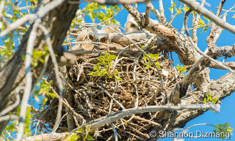
Springtime means not only is the weather active, so too is the wildlife. Great Horned Owl owlets in Thornton. (Shannon Dizmang)
Colorado’s famously highly variable weather seems to showcase itself during the month of May when a variety of weather conditions can be seen. This provides a prime opportunity for photos of everything weather to flora to fauna.
The month of May can bring extremes. Snow is not entirely uncommon during the month but more common is severe weather, particularly in the latter half of the month. Thunderstorms become more frequent and their associated hazards – lightning, wind, hail and tornadoes – are usual visitors. Providing additional subjects for pictures are the emerging spring flowers and our abundant wildlife.
Slideshow updated May 31, 2016. To learn more about how to send your photo to us for inclusion in the slideshow, see below the slideshow.
Showcasing images captured by ThorntonWeather.com readers as well as some of our own, our monthly slideshow covers the entire gamut of weather-related imagery.
Sunsets, sunrises, wildlife and of course every type of weather condition are vividly depicted in images captured from yours and our cameras.
[flickr_set id=”72157667503622900″]
What is missing in the slideshow above? Your photo!
Our monthly photo slideshow is going to feature images that we have taken but more importantly images that you have captured. The photos can be of anything even remotely weather-related.
Landscapes, current conditions, wildlife, pets, kids. Whimsical, newsy, artsy. Taken at the zoo, some other area attraction, a local park, a national park or your backyard. You name it, we want to see and share it!
Images can be taken in Thornton, Denver or anywhere across the extraordinary Centennial State. We’ll even take some from out of state if we can tie it to Colorado somehow.
We’ll keep the criteria very open to interpretation with just about any image eligible to be shown in our slideshows.
What do you win for having your image in our slideshow? We are just a ‘mom and pop’ outfit and make no money from our site so we really don’t have the means to provide prizes. However you will have our undying gratitude and the satisfaction that your images are shared on the most popular website in Thornton.
To share you images with us and get them included in the slideshow just email them to us or share them with ThorntonWeather.com on any of the various social media outlets. Links are provided below.


 Extreme weather can occur during in month in Colorado we well know. June however is when traditional spring severe weather arrives in the state oftentimes with hail, damaging wind and tornadoes.