|
Carol Rasmussen, NASA Using satellite data on how water moves around Earth, NASA scientists have solved two mysteries about wobbles in the planet’s rotation – one new and one more than a century old. The research may help improve our knowledge of past and future climate. Although a desktop globe always spins smoothly around the axis… Continue reading Two Mysteries About Wobbling Earth Have Been Solved |
All posts by Thornton Weather
March 2016 weather recap: A bit warmer than normal, much wetter and snowier
The month of March 2016 in Thornton was a bit of a tale of two halves. The first, mild and dry. The second, colder and much, much wetter.
We started out with above normal temperature readings dominating the daily temperatures. In fact 12 of the first 14 days of the month saw high temperatures above average, some well above. Other than a nice bit of rain on the 7th, those first two weeks were dry as well. All were courtesy of strong high pressure staying over the region.
Things cooled down briefly for the next few days and we received a nice bit of snow on the 17th and 18th. However, warm weather returned with back to back 70+ degree days on the 21st and 22nd.
March is however our snowiest month and Mother Nature delivered a walloping reminder of that on the 23rd. Blizzard conditions arrived early in the morning and persisted through the day. Schools and businesses shuttered as did the airport and major interstates.
Cool, unsettled weather conditions finished out the month. Another, light show of snow came on the 26th followed by flurries on the 31st.
Thornton’s overall average temperature for March was 41.4 degrees. This was very close to Denver’s official measurement of 41.6 degrees as taken out at DIA. The average monthly temperature for March is 40.4 degrees.
Thornton saw a maximum mercury reading of 72.4 degrees on the 21st and a low of 13.5 degrees on the 24th. Out at the airport, Denver saw its highest reading of 74 degrees on the 11th and a low of 10 degrees on the 24th.
In terms of precipitation, rain and snow combined to bring Thornton a wet 3.21 inches. The long term average for Denver in March is 0.92 inches.
Denver’s automated system claims a mere 0.90 inches of liquid precipitation at the airport. It is clear that they had a very incorrect reading from the blizzard on the 23rd. Their climate report for the month makes the note, “the precipitation for March 23rd is too low due to undercatch from blizzard. This value is under review. This could change the values below.”
Snowfall was abundant for the month and far exceeded the average of 10.7 inches for Denver. Here in Thornton we received 30.1 inches – our second highest monthly total in 10 years. The airport lagged considerably due to their location out in the middle of nowhere with 18.4 inches.
Click here to view Thornton’s March 2016 climate report.


From the National Weather Service:
CLIMATE REPORT
NATIONAL WEATHER SERVICE DENVER/BOULDER CO
1255 PM MDT FRI APR 1 2016

...................................

...THE DENVER CO CLIMATE SUMMARY FOR THE MONTH OF MARCH 2016...

CLIMATE NORMAL PERIOD 1981 TO 2010
CLIMATE RECORD PERIOD 1872 TO 2016

WEATHER         OBSERVED          NORMAL  DEPART  LAST YEAR`S
                 VALUE   DATE(S)  VALUE   FROM    VALUE  DATE(S)
                                          NORMAL
................................................................
TEMPERATURE (F)
RECORD
 HIGH              84   03/26/1971
 LOW              -11   03/28/1886
HIGHEST            74   03/11        73       1       81  03/16
LOWEST             10   03/24        11      -1        2  03/05
AVG. MAXIMUM     54.9              54.4     0.5     58.9
AVG. MINIMUM     28.3              26.4     1.9     31.2
MEAN             41.6              40.4     1.2     45.0
DAYS MAX >= 90      0               0.0     0.0        0
DAYS MAX <= 32      1               1.9    -0.9        2
DAYS MIN <= 32     21              23.6    -2.6       12
DAYS MIN <= 0 0 0.1 -0.1 0

PRECIPITATION (INCHES)
RECORD
 MAXIMUM 4.56 1983
 MINIMUM 0.03 2012

*THE PRECIPITATION FOR MARCH 23RD IS TOO LOW DUE TO UNDERCATCH
FROM BLIZZARD. THIS VALUE IS UNDER REVIEW. THIS COULD CHANGE
THE VALUES BELOW.

TOTALS 0.90* 0.92 -0.02* 0.79
DAILY AVG. 0.03* 0.03 0.00* 0.03
DAYS >= .01         9               5.9     3.1        5
DAYS >= .10         2               2.4    -0.4        3
DAYS >= .50         0               0.3    -0.3        0
DAYS >= 1.00        0*              0.1    -0.1*       0
GREATEST
 24 HR. TOTAL    0.49*  03/23 TO 03/23           03/19 TO 03/19

SNOWFALL (INCHES)
RECORDS
 TOTAL           18.4              10.7
RECORD MARCH     35.2                         2003

DEGREE_DAYS
HEATING TOTAL     716               763     -47      611
 SINCE 7/1       4704              5202    -498     4724
COOLING TOTAL       0                 0       0        0
 SINCE 1/1          0                 0       0        0

FREEZE DATES
RECORD
 EARLIEST     09/08/1962
 LATEST       06/08/2007
EARLIEST                        10/07
LATEST                          05/05
..........................................................

WIND (MPH)
AVERAGE WIND SPEED              11.7
RESULTANT WIND SPEED/DIRECTION   3/238
HIGHEST WIND SPEED/DIRECTION    53/340    DATE  03/23
HIGHEST GUST SPEED/DIRECTION    59/340    DATE  03/23

SKY COVER
POSSIBLE SUNSHINE (PERCENT)   MM
AVERAGE SKY COVER           0.60
NUMBER OF DAYS FAIR            3
NUMBER OF DAYS PC             20
NUMBER OF DAYS CLOUDY          8

AVERAGE RH (PERCENT)     48

WEATHER CONDITIONS. NUMBER OF DAYS WITH
THUNDERSTORM              1     MIXED PRECIP               0
HEAVY RAIN                0     RAIN                       0
LIGHT RAIN                4     FREEZING RAIN              0
LT FREEZING RAIN          0     HAIL                       1
HEAVY SNOW                1     SNOW                       4
LIGHT SNOW                8     SLEET                      0
FOG                      11     FOG W/VIS <= 1/4 MILE      2
HAZE                      3

-  INDICATES NEGATIVE NUMBERS.
R  INDICATES RECORD WAS SET OR TIED.
MM INDICATES DATA IS MISSING.
T  INDICATES TRACE AMOUNT.
Thornton’s April weather preview: Expect just about anything
 April marks a transition between winter and summer for most of the country but for Denver it is especially true as we can see a stunning variety of weather.
The proverbial April showers are certainly a possibility for Denver. Snow? Tornadoes? Thunderstorms? You bet – all can happen!
For good measure throw in a chance for hail and even dust storms and April gives every type of weather condition you could like – or hate.
April 3 to April 9: This Week in Denver Weather History

As we pointed out in our April weather preview, the month can bring just about any type of weather condition and we see that in our look back at this week in Denver weather history. From powerful, damaging winds to Arctic cold to heavy snowfall this has been an eventful week in the past.
From the National Weather Service:
31-3
In 1979…total snowfall of 6.6 inches was measured at Stapleton International Airport where north winds gusted to 31 mph on the 31st. The greatest accumulation of snow on the ground was 3 inches on the 1st.
31-4
In 1905…much rain and some snow occurred over the 5 days behind an apparent cold front. Precipitation totaled 2.00 inches. There was a thunderstorm on the 3rd. Snowfall totaled 3.0 inches on the 4th. North winds were sustained to 34 mph on the 1st and 2nd and to 30 mph on the 3rd. High temperatures during the period ranged from the upper 30’s to the lower 40’s. Low temperatures were in the upper 20’s and lower 30’s.
1-3
In 1945…snow fell across metro Denver for a total of 51 consecutive hours. While the storm was not accompanied by excessive snow…the long duration made the event a heavy snow producer. Snowfall totaled 10.7 inches in downtown Denver with 9.5 inches recorded at Stapleton Airport. North winds were sustained to 21 mph on the 1st; otherwise winds were not strong. The air mass was very cold for April. The high temperatures of 26 on the 2nd and 17 on the 3rd were record low maximums for the dates. The latter was also a record low maximum for the month. Warm weather following the storm quickly melted the snow.
In 1973…heavy snow fell at Stapleton International Airport where 8.7 inches were measured. Snow began late on the 1st and continued through early morning on the 3rd. Thunder accompanied the snow during the late morning and afternoon of the 2nd. North winds gusted to 33 mph on the 2nd and 37 mph on the 3rd. Snow only accumulated to a depth of 5 inches on the ground due to melting.
In 1977 a foot of snow fell in Boulder and Broomfield. The Denver-Boulder turnpike was closed for an hour after numerous minor traffic accidents. At Stapleton International Airport…snowfall totaled 4.7 inches and southeast winds gusted to 32 mph on the 2nd. The greatest depth of snow on the ground was only 3 inches due to melting.
2-3
In 1955…strong west to southwest winds raked metro Denver on both days. Sustained winds as high as 37 mph with gusts to 60 mph were recorded at Stapleton Airport where the visibility was reduced to 1/4 mile in blowing dust.
In 1974…a heavy snowfall of 6.7 inches was accompanied by northeast wind gusts to 33 mph which produced some blowing snow across metro Denver. Over eastern Colorado many highways and schools were closed due to near-blizzard conditions from the storm.
In 1986…the worst snow storm of the season blasted metro Denver. Heavy snow and high winds combined to close roads… Schools…and airports. Portions of all interstate Highways out of Denver were closed at times. The snow came after an exceptionally mild late winter and early spring; trees and bushes had already bloomed and leafed out. The snow and wind snapped many of these…causing power outages. Total snowfall amounts in metro Denver ranged from 1 to 2 feet with 2 to 3 feet in the foothills. Snowfall totaled 12.6 inches at Stapleton International Airport where north winds gusting to 39 mph reduced the visibility to 1/8 mile in snow and blowing snow. Most of the snow fell on the 3rd when temperatures hovered around 30 degrees for most of the day. The heavy snow halted traffic and closed businesses. A 59- year-old man was found dead from exposure in northwest Denver. The roof of a toy store in Northglenn collapsed. A 100 thousand square foot section of a greenhouse roof collapsed in Golden…destroying over a million dollars worth of plants.
In 2000…a combination of strong instability and moist upslope winds allowed for a heavy…wet spring snowstorm to develop in and near the Front Range foothills. The heaviest snow occurred in southern Jefferson County. Storm totals included: 14 inches near conifer…12 inches near Evergreen and on Floyd hill; 11 inches near Blackhawk…Morrison…and tiny town; 10 inches at Aspen Springs and Eldora Ski Area; 9 inches at Chief Hosa; and 8 inches at both Golden Gate Canyon and Rollinsville. Only 2.1 inches of snow fell at the site of the former Stapleton International Airport. North winds gusted to 36 mph at Denver International Airport on the 2nd.
In 2014…a storm system brought moderate to heavy snow to the Front Range Mountains…Foothills and Urban Corridor. Storm totals in the mountains and foothills included: 21.5 inches…8 miles north of Blackhawk; 15.5 inches near Rollinsville; 15 inches at Aspen Springs; 14.5 inches near Ward; 12 inches…6 miles southwest of Evergreen; 11 inches at Cabin Creek and 12 miles south-southwest of Georgetown; 10 inches at Winter Park; 8 inches near Conifer…Georgetown and Gross Reservoir; with 7.5 inches at Bailey and Intercanyon. In the Urban Corridor…storm totals included: 9.5 inches near Highlands Ranch…7 inches at Boulder… 6 inches near Castle Rock…with 5.5 inches at Lakewood and near Morrison. At Denver International Airport…3.4 inches of snowfall was observed.
2-4
In 1934…snowfall totaled 8.2 inches in downtown Denver from the afternoon of the 2nd through the early morning of the 4th. Most of the snow…6.8 inches…fell on the 3rd. Rain changed to snow behind a strong cold front on the afternoon of the 2nd. The cold front first appeared as a long-cigar shaped squall cloud to the north of the city. Strong north winds at sustained speeds of 33 mph with gusts to 43 mph produced much blowing dust and an abrupt fall in temperature…from a high of 68 on the 2nd to a low of 22 on the 3rd.
In 1964…a major storm dumped 10.9 inches of heavy wet snow on Stapleton International Airport where northeast winds gusted to 35 mph. Most of the snow…10.0 inches…fell on the 3rd.
2-5
In 1918…snowfall totaled 12.4 inches over downtown Denver. Most of the snow fell on the 3rd and 4th. Temperatures were in the 20’s and 30’s. Northwest winds were sustained to 24 mph on the 2nd.
3
In 1872…skies were cloudy and threatening until 11:30 am when it commenced to rain and continued to rain until 3:00 pm…when it turned into heavy snow with a very brisk north wind. Snow continued all night. Telegraph wires were downed between Denver and Cheyenne…and the night report could not be sent. Precipitation (rain and melted snow) measured 0.82 inch.
In 1887…north winds were sustained to 43 mph.
In 1894…northwest winds were sustained to 41 mph with gusts to 50 mph. The warm Chinook winds on the 2nd became a Bora as the temperature warmed to a high of only 52 degrees.
In 1900…southeast winds were sustained to 52 mph with gusts as high as 61 mph.
In 1945…the temperature warmed to only 17 degrees…the all-time record low maximum for the month.
In 1968…a snow storm of unusual severity for so late in the season caused ground blizzard conditions with near zero visibility in snow at times and severe drifting of snow over portions of northeastern Colorado and metro Denver. Highways were blocked to the north of Denver and to Colorado springs. Rain at the start of the storm contributed to power and communications outages. In metro Denver…snowfall totaled 7.0 inches at Stapleton International Airport where north winds gusted to 45 mph.
In 1978…a tornado was sighted by a national weather service observer 3 miles north of Stapleton International Airport near the rocky mountain arsenal. Security police on the arsenal called it a large dust devil…but four commercial airline pilots confirmed the phenomenon as a tornado or funnel cloud.
In 1981…a snowstorm hit northeastern Colorado…dumping 6 to 12 inches of snow in the foothills and 4 to 8 inches on the plains north of Denver. Snowfall totaled only 2.0 inches at Stapleton International Airport where north winds gusted to 24 mph.
In 1985…strong winds of 60 to 70 mph occurred in the foothills. The driver of a car in Nederland was slightly injured when the wind toppled an utility pole onto his vehicle. Northwest winds gusted to 53 mph at Stapleton International Airport where the visibility was briefly reduced to 2 miles in blowing dust.
In 1989…a northwest wind gust to 51 mph was recorded at Stapleton International Airport.
In 2011…high winds developing along the Front Range during the early morning hours. Peak wind gusts included: 92 mph… 7 miles northwest of Berthoud; 75 mph…2 miles west of Castle Rock; and 65 mph…2 miles west of Elbert. West winds gusted to 49 mph at Denver International Airport.
3-5
In 1996…the foothills west of Denver received 6 to 8 inches of new snow. Only 0.8 inch of snow fell at the site of the former Stapleton International Airport…along with some freezing drizzle on the 4th and 5th. North-northeast winds gusted to 30 mph at Denver International Airport on the 3rd.
3-6
In 1898…snowfall totaled 8.7 inches in downtown Denver over the 4 days. Northeast winds were sustained to 48 mph with gusts as high as 60 mph on the 3rd.
In 1983…a prolonged heavy snow storm blanketed the area along with very cold temperatures. The greatest amounts of snow fell in the foothills where 24 to 42 inches were measured. A foot of snow fell in Boulder. Snow fell for 50 consecutive hours at Stapleton International Airport on the 3rd through the 5th with a total snowfall of 8.8 inches and a maximum accumulation on the ground of 6 inches on the 5th. In Denver…the mercury failed to rise above freezing for 3 consecutive days…on the 4th…5th…and 6th…for the first time ever in April. Five daily temperature records were set from the 4th through the 6th. Record low temperatures of 12 degrees occurred on the 5th with 7 degrees on the 6th. Record low maximum temperatures of 25 degrees occurred on the 4th…27 degrees on the 5th… And 28 degrees on the 6th.
Continue reading April 3 to April 9: This Week in Denver Weather History
March 2016 top shots: Monthly photo slideshow
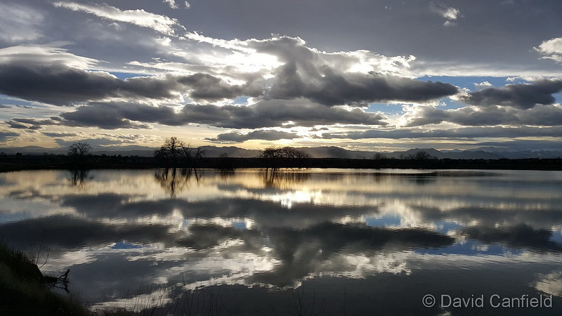
The month of March is the start of meteorological spring and while conditions do begin warming, winter weather is certainly out of the question. From hot to cold, snow to rain, the conditions can be very conducive to great pictures as we see in our slideshow.
March in Denver typically means frequent and rapid weather changes. The days grow longer and we start enjoying more sunshine and sometimes summer-like weather. However, on occasion arctic air masses can still force their way south into Colorado dropping temperatures quickly and markedly.
With the active wildlife, increased outdoor activities by us humans, and of course the weather, March imagery contains a wide variety of subjects and extremes.
- Slideshow updated March 31, 2016. To learn more about how to send your photo to us for inclusion in the slideshow, see below the slideshow.
Showcasing images captured by ThorntonWeather.com readers as well as some of our own, our monthly slideshow covers the entire gamut of weather-related imagery.
Sunsets, sunrises, wildlife and of course every type of weather condition are vividly depicted in images captured from yours and our cameras.
| [flickr_set id=”72157665126811690″] |
What is missing in the slideshow above? Your photo!
Our monthly photo slideshow is going to feature images that we have taken but more importantly images that you have captured. The photos can be of anything even remotely weather-related.
Landscapes, current conditions, wildlife, pets, kids. Whimsical, newsy, artsy. Taken at the zoo, some other area attraction, a local park, a national park or your backyard. You name it, we want to see and share it!
Images can be taken in Thornton, Denver or anywhere across the extraordinary Centennial State. We’ll even take some from out of state if we can tie it to Colorado somehow.
We’ll keep the criteria very open to interpretation with just about any image eligible to be shown in our slideshows.
What do you win for having your image in our slideshow? We are just a ‘mom and pop’ outfit and make no money from our site so we really don’t have the means to provide prizes. However you will have our undying gratitude and the satisfaction that your images are shared on the most popular website in Thornton.
To share you images with us and get them included in the slideshow just email them to us or share them with ThorntonWeather.com on any of the various social media outlets. Links are provided below.
So come on, get those camera’s rolling!
- Email: info@ThorntonWeather.com
- Facebook: https://www.facebook.com/ThorntonWeather
- Google+: https://plus.google.com/+Thorntonweather
- Twitter: @ThorntonWeather (https://twitter.com/thorntonweather)
Mild temps, slight chance for thunderstorms Tuesday; snow possible overnight
Thornton’s Tuesday looks to be a relatively pleasant day with mild temps but with some cloud cover. We also will see a return to wintry weather tonight through tomorrow although it won’t be anything too dramatic.
For today we start with partly sunny skies and we will see a good little bit of cloud cover throughout the day, increasing in the afternoon. Temperatures will be climbing to a pleasant high of 63 degrees.
The next storm system starts making itself felt this afternoon although for the most part, its effects will be limited in our area as it will be mainly to our north. We do see a slight chance for some thunderstorms and shower activity from about 3:00pm through midnight tonight.
As temperatures drop overnight, light snow will be possible in the early morning hours through much of the day tomorrow. Accumulations will be quite light though, perhaps an inch or two for the entire event. The good news is that while temperatures will be cool for the balance of the workweek, they will rebound nicely for the weekend. Get the extended weather forecast here.

Time lapse video: Thornton’s March 2016 blizzard
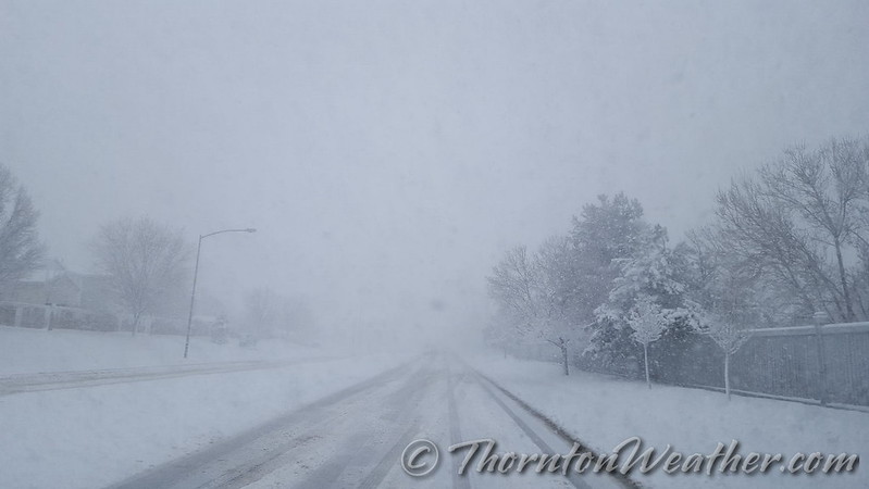
It is hard to believe so much snow can fall over such a short period of time. Over just more than 12 hours Thornton received 21.7 inches – our biggest snowstorm since 2006. Our east facing webcam captured all the action from start to finish.
The video below starts at midnight on the 23rd with dry conditions. By about 2:00am rain falls but that quickly transitions to snow.
It is after daybreak that the storm gets started in earnest and the heavy snowfall almost entirely obscures the view at points. As is typical in Colorado, by mid-afternoon, we actually start to see some blue skies.
The video covers 19 hours in about 39 seconds. There are a few ‘hiccups’ in the video that you might notice. These were when we had brief power outages.
March 27 to April 2: This week in Denver weather history
With March being historically our snowiest month we would expect to see plenty of snow events this week in Denver weather history and we do indeed. Also notable however is the other extreme – that of dangerously dry conditions. We see one event, in 1963, that scorched 25,000 acres of ranchland in Weld County.
From the National Weather Service:
25-27
In 1904…heavy snowfall totaled 7.0 inches in downtown Denver.
26-27
In 1886…heavy snowfall totaled 7.1 inches in downtown Denver.
In 1911…post-frontal north winds were sustained to 48 mph on the 26th and to 47 mph on the 27th.
In 1931…a cold front brought snow and very cold weather to the city. Snowfall totaled 7.3 inches over downtown Denver with most of the snow…6.4 inches…occurring on the 26th… When northwest winds were sustained to 38 mph with gusts to 44 mph. High temperature of 31 degrees on the 26th equaled the low temperature of the previous day as the temperature plunged to a low of 1 degree below zero. High temperature of only 15 degrees on the 27th was a record low maximum for the date. Low temperature of 2 degrees below zero on the 27th was not a record.
In 1975…a major pre-Easter blizzard…the worst since the vicious storm of 1949…battered northeastern Colorado and left livestock losses in millions of dollars…but metro Denver escaped the main brunt of the storm and received only 5.0 inches of snowfall. North winds gusted to 38 mph at Stapleton International Airport where temperatures plunged from a high of 50 degrees to 18 degrees by midnight on the 26th.
In 1991…heavy snow fell over portions of the eastern foothills with 9 inches recorded at Lake Eldora west of Boulder. The snow spread across metro Denver…but snowfall totaled only 1.7 inches at Stapleton International Airport where north to northeast winds gusting to 31 mph on both days produced some blowing snow.
27
In 1873…a severe wind and sand storm damaged buildings in the city. At 11:00 am brisk west winds blew clouds and sand into the city…which continued for an hour when it abated some. At 2:00 pm another terrific sand storm blew a gale from the west. The storm lasted 30 minutes…but winds remained brisk the rest of the day.
In 1884…a windstorm struck the city at mid-morning and lasted until midnight. Sustained winds of 40 to 60 mph unroofed some buildings and blew others down. A few people were injured…but none fatally.
In 1896…southwest winds sustained to 60 mph with gusts as high as 70 mph warmed the temperature to a high of 59 degrees.
In 1905…north winds were sustained to 40 mph.
In 1939…freezing drizzle deposited glaze as thick as 1/4 inch from late morning through late afternoon. No damage was reported.
In 1956…strong and gusty winds raked metro Denver all day behind a pacific cold front. Wind gusts to 58 mph at Stapleton Airport briefly reduced the visibility to 1 mile in blowing dust.
In 1987…snow and wind closed many highways across eastern Colorado for the second time in less than a week. I-25 was closed south of Denver and I-70 was closed east of Denver for nearly 48 hours. Metro Denver only received around 4 inches of new snow…but snow and blowing snow caused air traffic delays of up to 3 hours at Stapleton International Airport where snowfall totaled 3.5 inches and north winds at 15 to 25 mph gusted to 40 mph. Temperatures hovered in the 30’s for much of the day.
In 1997…strong winds developed behind a fast moving cold front. While the highest winds were north and northeast of metro Denver…northwest winds gusting to 56 mph at Denver International Airport produced widespread blowing dust…which briefly reduced the visibility to 2 1/2 miles.
27-28
In 1951…heavy snowfall totaled 6.5 inches at Stapleton Airport where north winds gusted to 38 mph on the 27th and 41 mph on the 28th.
In 1972…heavy snowfall of 6.2 inches was measured at Stapleton International Airport…where northeast winds gusted to only 21 mph.
In 1980…a major blizzard struck the northeastern Colorado plains…closing both I-70 and I-76 to the east of Denver for a time. Some areas received 1 to 2 feet of snow. Drifts were 4 to 8 feet high. The storm killed many young livestock. At Stapleton International Airport…snowfall totaled 6.7 inches from the storm and north winds gusted to 29 mph.
In 2002…high winds developed in the foothills west of metro Denver. Winds gusted to 81 mph near Fritz Peak…72 mph at Rollinsville…and 70 mph at Blackhawk. West winds gusted to 51 mph on the 27th and to 45 mph on the 28th at Denver International Airport where the temperature warmed to a high of 69 degrees on the 28th.
27-29
In 1948…high winds raked Boulder. A wind gust to 75 mph was recorded at Valmont. Sustained winds in excess of 35 mph were estimated in Boulder. Minor damage was reported.
In 1961…heavy snowfall totaled 9.5 inches at Stapleton Airport over the 3 day period. Most of the snow…5.3 inches…fell on the 28th. Winds were generally light and gusted to only 22 mph from the north.
28
In 1886…the lowest recorded temperature in March…11 degrees below zero…occurred.
In 1911…a thunderstorm produced snowfall of 0.4 inch…which was the only measurable snowfall of the month…making the month the second least snowiest March on record.
In 1962…a vigorous cold front produced strong winds across eastern Colorado. North winds gusted to 46 mph at Stapleton Airport where visibility was briefly reduced to 3/4 mile in blowing dust. A construction worker was injured in Aurora when he was struck by a windblown piece of plywood.
28-29
In 1891…rain changed to snow and totaled 9.7 inches in the city. Northeast winds were sustained to 12 mph with gusts to 28 mph on the 28th.
In 1910…a strong cold front brought much wind…rain…and and snow to the city. Rain on the 28th changed to snow early on the 29th. Snowfall totaled only 2.8 inches…but north winds were sustained to 50 mph on the 29th. Precipitation from the storm totaled 0.96 inch.
In 1994…moist upslope winds combined with an upper level system to dump 5 to 7 inches of snow along the eastern foothills and across metro Denver. Snowfall totaled 6.3 inches at Stapleton International Airport where northeast winds gusted to 39 mph. Thirteen inches of new snow were measured at the Eldora Ski Area west of Boulder.
28-30
In 1949…a major winter storm dumped 11.3 inches of snow over downtown Denver. Snowfall totaled 10.4 inches at Stapleton Airport. North to northeast winds were sustained to 17 mph.
In 1985…a slow moving snow storm moved across the state. Denver received only 4.0 inches of snowfall with amounts in the foothills totaling 1 to 2 feet. Still…this was enough snow in Denver to cause flight delays of up to 6 hours at Stapleton International Airport on the night of the 29th. East winds gusted to 28 mph on the 28th.
29
In 1887…west winds sustained to 44 mph warmed the temperature to a high of 62 degrees.
In 1921…post-frontal northeast winds were sustained to 46 mph with gusts to 52 mph.
In 1925…southeast winds were sustained to 46 mph with gusts to 48 mph. These were the strongest winds of the month that year. The winds warmed the temperature to a high of 72 degrees.
In 1934…a construction worker was killed by lightning as he walked with a shovel on his shoulder along Cherry Creek in the city. The thunderstorm produced light rain.
In 1967…a southwest wind gust to 52 mph was recorded at Stapleton International Airport. The warm Chinook winds warmed the temperature to 79 degrees equaling the record for the date.
In 1979…a tornado touched down 4 miles southwest of Parker… But caused no reported damage.
In 1998…four children attending a birthday party in Denver were injured when an apparent dry microburst produced a sudden strong wind gust which blew an inflatable playhouse they were occupying into a neighbors yard. The playhouse scraped the roof of the host’s two-story house…then landed in the adjoining yard. The children were treated for minor head injuries and cuts.
29-30
In 1938…overnight heavy snowfall was 6.3 inches over downtown Denver.
In 1982…strong winds buffeted metro Denver…breaking windows and damaging roofs. Wind gusts to 90 mph were recorded in Boulder and 51 mph at Stapleton Airport. The strong winds flattened a condominium under construction in Lakewood.
In 1991…1 to 6 inches of snow fell across metro Denver with the heaviest snow confined to the foothills. Six inches of snow was recorded at South Platte in the foothills southwest of Denver and 3 inches at Castle Rock. Snowfall totaled only 0.7 inch at Stapleton International Airport where northeast winds gusted to 33 mph on the 29th.
29-31
In 1970…snowfall totaled 6.0 inches at Stapleton International Airport. Heavy snow accumulation in Boulder on the 29th caused the collapse of a carport at an apartment building…damaging 11 automobiles. Northeast winds gusted to 24 mph at Stapleton International Airport.
Continue reading March 27 to April 2: This week in Denver weather history
Time lapse video: Thornton’s March 23, 2016 blizzard
To say the storm that pounded the Colorado Front Range was a big one does not do it justice. In less than 24 hours Thornton would see blizzard conditions and our second heaviest snowfall of the previous 10 years.
Light rain began in the early morning hours but that soon transitioned to snow. The white stuff would continue to fall into the evening. Strong winds helped whip the snow and create blizzard conditions grinding the Colorado Front Range to a halt.
Thornton would tally 20.1 inches of snow, one of the heftier totals from the area.
The video below begins at midnight and runs through 7:00pm.
Thornton’s March 2016 blizzard – Live social feed
 Just yesterday we saw temperatures in excess of 70 degrees. Wednesday, March 23, will bring blizzard like conditions to Thornton. That is springtime in Colorado!
The National Weather Service has issued a Blizzard Warning which will be in effect until 6:00pm. Road conditions have deteriorated throughout the day and will continue to do so. Power outages are occurring and most schools and government offices are closed as are many businesses.
Throughout the period we will of course be monitoring the system and posting regularly to our Facebook page and Twitter feed. You can follow along in real time below. We are also on Google+ here.
For comprehensive look at the storm, please monitor our Winter Weather Briefing page.