All posts by Thornton Weather

ThorntonWeather.com is your local source for live Thornton, Colorado weather conditions and news!

November 15 to November 21 – This week in Denver weather history

November 15 to November 21 - This week in Denver weather history

Any week in Denver weather history is filled with numerous notable weather events and this week is no different.  We have everything from major snowstorms to damaging winds and much more.  However, one item is particularly notable and historic.  It was on the 20th of November in 1871 that the first, official weather observation took place in Denver.  Henry Fenton, Observer Sergeant of the United States Army Signal Service, made the report at 5:43 am.  The office was located on the 2nd floor of a building at the corner of Larimer and G Streets, now 16th Street.  Scroll down to see what the report said.

From the National Weather Service: 

From the 12th to the 15th:

In 1909…light snowfall totaled 6.7 inches in downtown Denver over the 4 days.  This was the first measurable snowfall of the season.  Northeast winds were sustained to 15 mph on the 12th.

From the 14th to the 15th:

In 1917…overnight rainfall was 0.03 inch.  This was the only measurable precipitation of the month…making it the 5th driest November on record.
 
In 1985…3 to 6 inches of snow fell across metro Denver. Snowfall totaled 3.8 inches at Stapleton International Airport where northeast winds gusted to only 13 mph.
 
In 2005…a winter storm that brought heavy snow to the mountains also spread heavy snow into the foothills to the west of Denver.  Snowfall totals included:  14 inches at aspen springs…13 inches near Pinecliffe…and 12 inches near Nederland.  Interstate 70 along with U.S. Highway 40 had to be closed near Idaho Springs due to snow…poor visibility in blowing snow…numerous accidents…and an increased avalanche danger.  High winds were recorded in the foothills on the 14th.  Winds gusted to 89 mph at Georgetown and to 91 mph on Sugarloaf Mountain west of Boulder.  Strong microburst winds associated with a dissipating rain shower gusted to 61 mph at Denver International Airport on the 14th.

From the 14th to the 18th: 

In 1964…the first measurable snowfall of the season totaled 6.0 inches at Stapleton International Airport where northeast winds gusted to 32 mph on the 14th. Most of the snow…4.2 inches…fell on the 14th.  This was the only measurable snow of the month.

On the 15th:

In 1902…4.0 inches of snow fell over downtown Denver. This was the only measurable snow of the month. Northeast winds were sustained to 18 mph with gusts to 20 mph.
 
In 1906…strong winds howled and roared across Boulder… Causing several thousand dollars in damage.  The strong winds caused one fatality and minor injuries to others. West winds were sustained to 46 mph in downtown Denver where the strong Chinook winds warmed the temperature to a high of 74 degrees.
 
In 1944…the low temperature dipped to 32 degrees.  This is the latest date of the first freeze in Denver.
 
In 1949…a trace of rain fell.  Another trace of rain on the 11th was the only precipitation of the month…making the month one of the driest Novembers on record and the least snowiest with no snow.  This was the first November since 1882 without snow.
 
In 1960…strong winds caused 2 thousand dollars damage to a new school building in Boulder where wind gusts were estimated to 70 mph.  Wind gusts to 40 mph were recorded in downtown Denver.  Damage occurred to utility lines…signs… And trees.  Northwest winds gusted to 44 mph at Stapleton Airport.
 
In 1986…strong Chinook winds howled over the Front Range foothills.  The highest wind gust…81 mph…was recorded at Table Mesa in Boulder.  West winds gusted to 31 mph at Stapleton International Airport.
 
In 1987…the first measurable snow of the season was also a major snowstorm.  The snow combined with strong winds to close I-70 east of Denver and I-25 to Colorado Springs. Snow accumulations ranged from 6 to 9 inches across metro Denver with 10 to 20 inches in the foothills.  At Stapleton International Airport…6.1 inches of snow fell and north winds gusted to 47 mph reducing the visibility to as low as 1/8 mile in heavy snow.  Strong north winds at 20 to 30 mph with frequent gusts to 40 mph and temperatures hovering around 30 degrees plunged wind chill temperatures to 5 below zero.
 
In 1988…the season’s first snow storm hit metro Denver. The storm dumped 2 to 5 inches of snow…which caused numerous traffic snarls and accidents.  North wind gusts to 43 mph caused some blowing snow.  Snowfall totaled 2.5 inches at Stapleton International Airport.  This was the latest first snow of the season.  No traces of snow had occurred earlier in the season.

Continue reading November 15 to November 21 – This week in Denver weather history

First of two storm systems arrives in Thornton as the snow starts falling

A live view of ThorntonWeather.coms east facing webcam.
A live view of ThorntonWeather.com's east facing webcam.

With snow having been falling in the mountains west of Denver much of the day and it now arriving in the metro area, all eyes are focused on two storm systems set to impact Colorado in a span of 48 hours.  The storms have the makings to be a major winter weather event.

The first system is starting to affect the Denver area late this afternoon.  Temperatures have begun to drop and most of the precipitation that is falling is coming down as snow.  This will continue this evening through about midnight with the snow possibly becoming heavy at times as snow bands move through.  Overnight there will be a lingering slight chance for continued snow but for the most part the period will be a lull between storms.  Between 1 and 4 inches can be expected in the metro area before dawn tomorrow. 

The second and more potent system arrives tomorrow and that has caused a Winter Storm Watch to be issued that is in effect from Saturday afternoon through Sunday afternoon.  The watch area stretches from south of Pueblo, through the Denver area and to the Wyoming border. 

Continue reading First of two storm systems arrives in Thornton as the snow starts falling

Denver sets new record high minimum for November 12th

Denver broke the record high minimum temperature for the date yesterday.

The Mile High City has enjoyed some great weather this past week and one weather record has officially been set. Just before midnight last night, the temperature at Denver International Airport dropped to 45 degrees. This sets a new record high minimum for November 12th, breaking the old record of 44 degrees set in 1894.  Thornton however wasn’t near as warm as we had a low temperature of 40.5 degrees.

The warm weather pattern though is set for a big change this weekend as you can see in our forecast. Two systems will begin to impact the area, the second of which arrives Saturday afternoon and could bring a good deal of snow to the area. Get the details on the Winter Storm Watch here.

It is important to remember though that the National Weather Service moved Denver’s official measurements to DIA 14 years ago from the former Stapleton site. This has caused a major change in Denver’s climate and weather records. Data shows that DIA runs hotter on the highs, colder on the colds and records less moisture than what stations closer to Denver do. This has resulted in Denver’s historical climate records being skewed.

Some say Denver’s climate records have forever been altered due to the station move and as such any weather record should have an asterisk attached to it. For more on the controversy, be sure to read our Examiner.com investigative series:

Examiner.com Investigates
Do Denver weather and climate records have an asterisk attached?

Part 1 – Overview and history.

Part 2 – Data analysis. Is there a problem?

Part 3 – Solutions, conclusions and why you should care.

Data analysis slideshow.

November 12, 2009 – Denver gets new National Weather Service monitoring station

Denver gets new National Weather Service weather station near downtown

Denver now as an official weather monitoring station closer to downtown but some say this doesnt solve the problem of the citys climate records being altered. (Examiner.com)
Denver now as an official weather monitoring station closer to downtown but some say this doesn't solve the problem of the city's climate records being altered. (Examiner.com)

It only took 14 years but Denver finally has an official monitoring station near downtown again. The new station amongst the greens of City Park Golf Course finally gives residents of Denver a place to see what the weather is doing closer to home.

With the opening of Denver International Airport in 1995, the National Weather Service moved its station to the new airport. That distance of 12 miles from the old Stapleton facility to DIA confounded citizens, television meteorologists and weather enthusiasts as they all noted that no one lives out at the airport and the conditions reported there do not reflect what is happening closer to town.

Recognizing the problem, a public-private partnership came together to do what they could to rectify the problem. The City and County of Denver, the Denver Museum of Nature and Science, the National Weather Service and NOAA, 7News Chief Meteorologist Mike Nelson and Colorado State Climatologist Nolan Doesken identified a site for the new station.

Eclar Fence and Mercury Electric donated the infrastructure for the new site. Weather equipment manufacturer Vaisala donated the weather monitoring hardware and services, estimated at up to $60,000.

Certainly there is little doubt the new station will provide area residents the ability to view conditions closer to where they actually live. The new station will not however address the very real problem of Denver’s climate records having been altered since the move to DIA. The National Weather Service has said the official records for Denver will still come out of DIA and as such many believe those records come with an asterisk.

There's more to this story on the Denver Weather Examiner's site!Why is there still a problem with Denver’s climate records?  What does the new station look like?  Check out the complete story including photos of the station, an interactive map and more on Examiner.com.

New movie ‘2012’ adds a new scale to the disaster movie genre

The new movie 2012 depicts natural disasters on a global scale. In the scene depicted above, the USS John F Kennedy is carried on a tsumani and about to crush the White House. (Columbia Pictures)
The new movie "2012" depicts natural disasters on a global scale. In the scene depicted above, the USS John F Kennedy is carried on a tsumani and about to crush the White House. (Columbia Pictures)

Natural disasters have long been a staple of the big screen and a new movie set to hit theatres this week takes the genre to a new height. “2012” by director Roland Emmerich depicts cataclysmic disasters on a global scale brought about on December 21, 2012 – the mythical end of the Mayan calendar.

Disaster movies have shown tornadoes, hurricanes, earthquakes and tsunamis but rarely has a film been made that included every type of disaster imaginable. “2012” brings all disasters together with scenes of California falling off into the ocean, fireballs raining from the sky, the Sistine Chapel collapsing on devout worshipers and even the aircraft carrier USS John F. Kennedy being dumped ashore on top of the White House by a giant wave.

An all-star cast featuring John Cusack, Danny Glover, Thandie Newton, Woody Harrelson, Chiwetel Ejiofor and Amanda Peet depict man’s struggle to survive the incredible calamity. As one of the movie’s fictional characters says, “Our mission is to ensure the continuity of our species.”

There's more to this story on the Denver Weather Examiner's site!For more about the movie, how it ties into the Mayan calendar and to watch the trailer, see the rest of this story on the Natural Disasters Examiner.

November 8 to November 14 – This week in Denver weather history

November 8 to November 14 - This week in Denver weather history

Wind is always a factor on the plains and the fall usually brings a great deal of it, especially in November.  Our look back at this week in Denver weather history shows that event and snow are quite common this time of year.

From the National Weather Service:

From the 7th to the 8th:

In 1969…wind gusts to 48 mph in downtown Boulder caused minor damage.

On the 8th:    

In 1896…southwest Chinook winds sustained to 42 mph with gusts as high as 46 mph warmed the temperature to a high of 53 degrees.
 
In 1977 near-blizzard conditions in blowing snow caused the closure of I-70 to the west of Denver in clear creek canyon and east of Denver to Limon.  Northeast wind gusts to 46 mph were recorded at Stapleton International Airport where snowfall totaled only 1.1 inches.
 
In 1984…a rare November thunderstorm produced west winds gusting to 31 mph…but only 0.04 inch of rain at Stapleton International Airport.
 
In 1996…high winds gusting from 80 to 100 mph were recorded at Wondervu in the foothills southwest of Boulder.  West northwest winds gusted to 32 mph at Denver International Airport.
 
In 2006…the temperature in Denver climbed to a high of 80 degrees.  This was the first time the temperature had ever exceeded the 70’s in November since records began in 1872. This new all-time record maximum temperature for the month of November was also a new daily record and the highest temperature ever recorded so late in the season.

Continue reading November 8 to November 14 – This week in Denver weather history
Predictions of climate change induced natural disasters falling flat

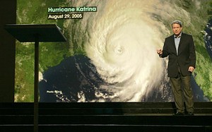
Former vice president Al Gore famously used an image of Hurricane Katrina to illustrate his argument that natural disasters will increase in intensity and frequency.  Empirical data howeverhas shown that is not the case. (An Inconvenient Truth)
Former vice president Al Gore famously used an image of Hurricane Katrina to illustrate his argument that natural disasters will increase in intensity and frequency. Empirical data howeverhas shown that is not the case. (An Inconvenient Truth)

Manmade climate change is said to present humankind with some of its greatest challenges in the planet’s history, not the least of which is an alarming increase in frequency and intensity of natural disasters. Massive flooding, super-powered hurricanes, endless tornado seasons and more have all been said to be the direst of consequences of global warming.

In his movie “An Inconvenient Truth”, Al Gore famously proclaimed that, “Temperature changes are taking place all over the world and that is causing stronger storms.” Standing with Hurricane Katrina as a backdrop, the former vice president issued a cautionary tale of disaster in the making, all due to our irresponsible handling of the atmosphere. As recently as February Mr. Gore was giving a presentation showing flooding, drought and wildfires saying, “This is creating weather-related disasters that are completely unprecedented.”

President Barack Obama, in a town hall meeting in April echoed the Nobel laureate’s comments saying, “You’re now looking at huge, cataclysmic hurricanes, complete changes in weather patterns.” He followed that in September when in a speech before the United Nations he claimed, “More powerful storms and floods threaten every continent.”

But what if you predicted global natural disaster catastrophes and they didn’t happen? Does that invalidate your entire message? This is the conundrum faced by climate change alarmists as many of their predictions begin to fall flat.

There's more to this story on the Denver Weather Examiner's site!Learn more about the evidence and find out why even some alarmists say these claims of ‘doom and gloom’ are hurting their case on Examiner.com.

Denver sets new high temperature record for November 5th

Denver broke the record high temperature for the date today.

Everyone in the Mile High City has been enjoying an extraordinarily beautiful November day today. As we mentioned in our morning forecast on Examiner.com, temperatures were expected to reach record-setting highs and that has been the case.

At 1:49pm the official temperature as taken at Denver International Airport reached 77 degrees. This broke the record high for the date last of 76 degrees set in 1945 and before that in 1916.

Here in Thornton we actually were a good bit warmer than the offical high.  ThorntonWeather.com reached a high of 79.9 degrees at 12:12pm.

As always, we have to ask the question: Is this really a record or not? Some say Denver’s climate records have forever been altered and as such any weather record should have an asterisk attached to it. Why? Get the details on that story here.

Where are the tornadoes? 2009 tornado reports well below normal levels

Tornado activity so far in 2009 has been well below normal. This has researchers wondering what has happened to the tornadoes?

Tornado activity in the United States for 2009 is reaching unusually low levels according to statistics from NOAA’s Storm Prediction Center (SPC). By its latest count as of Sunday, November 1st, 1040 tornado reports have been received this year placing it in the 10th percentile since 1954 (see chart below).

Tornadoes occur in every month on the calendar but 2009 started with far below normal numbers for the first three months of the year. As the traditional severe weather season approached during the spring, tornado numbers returned to near average but have since fallen into a decline.

Similarly, tornado deaths in 2009 are far below the average. The three year running average from 2006 to 2008 saw an average of 91 fatalities per year. Over the longer term, the United States experiences 80 per year. Thus far in 2009 only 22 deaths have been reported as a result of twisters. There was nearly a five month period from May 13th to October 9th when there were no deaths at all recorded.

There's more to this story on the Denver Weather Examiner's site!Why so few tornadoes?  For some possible answers and how this ties into global climate change, get the full story on Examiner.com.

Hurricanes MIA – Tropical cyclone activity at 30-year low

Tropical cyclone activity continues to decline despite beliefs that it would increase as a result of global warming.  (NOAA)
Tropical cyclone activity continues to decline despite beliefs that it would increase as a result of global warming. (NOAA)

For the third year in a row, tropical cyclone activity sits near a 30 year low and the 2009 Atlantic hurricane season is showing low levels not seen since 1997. Researchers at Florida State University said that despite what has appeared to be an active season in the Pacific, continual declines in activity are being realized across the globe.

A year ago researcher Ryan Maue documented ‘a remarkable downward trend’ and that trend has continued to flirt with historic lows. Using a measurement called the Accumulated Cyclone Energy index (ACE), Maue said that “2009 as a whole is still well behind normal climatology.”

The ACE index is the standard for measuring tropical cyclone activity. It combines the frequency, duration and intensity of the storms into a numerical index that can be used for historical comparisons.

Through October 2009, the global ACE index for the year sits at 525 – well below the norm of 769. Similarly, if looked at separately both the northern and southern hemisphere activity show well below average numbers. Breaking it down further by basins, the North Atlantic, Western Pacific, Eastern Pacific and North Indian basins are seeing below average ACE as well.

Examiner.com - Get inside Denver weatherGet the rest of this story and find out how this relates to climate change on Examiner.com.

Why do we link to Examiner.com?  Click here to find out.