All posts by Thornton Weather

ThorntonWeather.com is your local source for live Thornton, Colorado weather conditions and news!

So what is the story with Examiner.com?

Why does ThorntonWeather.com share stories and links with Examiner.com?

We are oftentimes asked why we have links to Examiner.com on ThorntonWeather.com and why we plug stories from them.  The reasons stem from our interest on the topics at hand but also because by your visiting Examiner.com, you support ThorntonWeather.com.  

Some background on Examiner.com might be useful.  Examiner.com was launched in 2008 by Clarity Media Group, a company owned by Phillip Anschutz.  The site is essentially a living example of ‘citizen journalism’ featuring local news stories on hundreds of topics written by people titled ‘Examiners’ who are knowledgeable in their given topic area.  There are now hundreds of local editions of Examiner.com including of course Denver. 

We were recruited to write for Examiner.com when it first launched, initially as the Denver Weather Examiner and more recently we are also writing as the Natural Disasters Examiner and Climate Change Examiner.  

Why do we write for Examiner.com?  

First and foremost it is because we are passionate about weather and climate and enjoy sharing news stories about those topics.  Weather is one of the things that affect the lives of every single person on earth and that is fascinating to us.  

By writing for Examiner.com, we have a pretty big stage on which to have our topic features – the site is one of the fastest growing on the Internet and now ranks 82nd in overall traffic on the Internet with more than 12 million people a month visiting it.  That ranks higher than popular sites like drudgereport.com, cbs.com and newsweek.com! 

Examiner.com - Get inside Denver weatherSecondly, quite frankly we do get paid for writing for Examiner.com and that money directly supports and helps to pay for ThorntonWeather.com.  The weather station hardware, software, lightning detectors, and more that we use here on ThorntonWeather.com is very expensive.  Factor in computer costs, website services and more and it isn’t cheap.  We don’t charge for ThorntonWeather.com and never will but Examiner.com helps to offset the very real costs we do incur in operating the site.  

By reading an Examiner.com story we post in our news section or checking out the links on the left to our Examiner.com topic areas, you are supporting ThorntonWeather.com directly.  So, if you like ThorntonWeather.com, we ask you to check out our stories on Examiner.com – not only is Examiner.com a great, local news source, it also is a great way to help us!  You can also support us by checking out the few advertisers you see on the site.  

If you ever have any questions about our site, Examiner.com or any weather-related topic, please contact us.  Thank you as always for supporting ThorntonWeather.com. 

On the net: 

Pine beetles as global warming warning? Not so much.

Is global warming responsible for the pine beetle spread or is it something else?

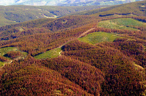
Much has been said here in Colorado about the pine beetle outbreak in the beautiful mountains west of Denver.  Anyone who travels in the high country has seen and most likely taken note of the patches of dead, brown pine trees. 

More than one news story has reported that the beetles were a harbinger of things to come as a result of global warming and manmade climate change. 

Interestingly enough, that isn’t necessarily the case.  As reported in the Climate Change Examiner, man may be partially responsible but it isn’t CO2 emissions that are to blame.  Mismanagement of forests and a ‘perfect storm’ of other items can be fingered as well.

From the Climate Change Examiner:

A tiny little bug about the size of a grain of rice has become a focal point in the debate about manmade climate change. Over the last 12 years, the mountain pine beetle has spread quickly through the Mountain West and Canada killing millions of acres of pine trees.

The beetle thrives when conditions are drier and warmer than average and some experts have blamed its spread on manmade climate change and a warming environment. From Canada south to Colorado, images of acres of dead, brown trees amongst their healthy neighbors make for a stark picture of what may be forests in decline.

Global warming activists have been quick to seize on the pine beetle ‘epidemic’ as a sign of things to come and an impending ecological disaster. In truth, drawing the line between manmade climate change and the pine beetle outbreak is a stretch that few experts make. Rather, most see the outbreak as a natural function of forests and in many ways it is Mother Nature correcting man’s previous mistakes.

There's more to this story on the Denver Weather Examiner's site!Get the complete story on Examiner.com and find out why even state foresters aren’t blaming man entirely.

Denver ties high temperatures record for the date

Denver tied the record high temperature for the date today.

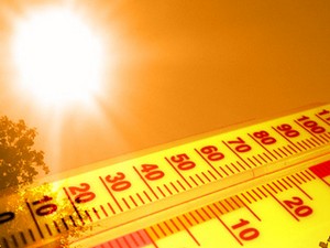
At 3:44pm today, the temperature at Denver International Airport reached 84 degrees.  This tied the record high temperature for October 18th set in 2003 and 1958.  The average temperature for this date is 68 degrees so we exceeded that by a large margin. 

From record setting cold last week to record setting warmth this week – you have to love Colorado weather! 

Was it really a record though?  Examiner.com investigates: Do Denver weather and climate records have an asterisk attached?

Here in Thornton we were actually a touch warmer reaching 85.9 degrees.  We have one more day of above normal temperatures ahead on Monday before we see a change that will bring cooler temps and possibly rain and snow.

October 18 to October 24 – This week in Denver weather history

October 18 to October 24 - This week in Denver weather history

This week is an extremely eventful one in Denver weather history with a wide variety of conditions having been experienced in the past.  Wind and snow are probably the two most dominant items, none more so than the blizzard that struck 12 years ago on the 24th.  That storm ravaged the city, closed the airport and highways and was responsible for four deaths.

From the National Weather Service:

From the 17th to the 19th:

In 1908…a moist…heavy…wet snowfall totaled 13.0 inches in downtown Denver over the 3 days.  Rain from early morning on the 17th changed to snow by late afternoon and continued through the late morning of the 19th.  Due to temperatures in the 30’s and melting…the most snow on the ground was only 5.0 inches at 6:00 pm on the 18th.  Northwest to northeast winds were sustained between 12 and 20 mph during the storm.  Precipitation totaled 1.82 inches.

On the 18th:

In 1875…the haze was so dense that the mountains were not visible from downtown Denver for most of the day.
 
In 1937…a vigorous cold front produced north winds sustained to 32 mph with gusts to 41 mph.  Rain and snow totaled 0.16 inch.  Post-frontal snowfall of 0.8 inch was the only snowfall of the month.
 
In 1960…post-frontal upslope rain changed to snow. Snowfall was 2.2 inches at Stapleton Airport where precipitation (rain and melted snow) totaled 1.58 inches.
 
In 1971…wind gusts to 48 mph were recorded in downtown Boulder.  West winds gusted to 30 mph at Stapleton International Airport.
 
In 1999…heavy snow developed in the foothills west of metro Denver with lesser amounts across the city.  Snowfall totals included:  7 inches near Nederland…6 inches in Boulder…and 5 inches at Chief Hosa.  Only 1.2 inches of snow were measured at the site of the former Stapleton International Airport.

From the 18th to the 23rd:

In 2003…an extended warm spell resulted in 5 new temperature records.  The high temperature of 84 degrees on the 18th equaled the record high for the date.  High temperatures of 86 degrees on the 19th…83 degrees on the 21st…and 84 degrees on the 22nd were record highs for the dates.  Low temperature of 49 degrees on the 23rd was a record high minimum for the date.  Low temperatures during the period were in the 40’s and lower 50’s.

On the 19th:

In 1887…northwest winds sustained to 42 mph were recorded in the city.
 
In 1982…3 to 6 inches of snow fell over northwest metro Denver…including Boulder.  Only 1.2 inches of snowfall were recorded at Stapleton International Airport where north winds gusted to 35 mph.  This was the first measurable snowfall of the season.

Continue reading October 18 to October 24 – This week in Denver weather history

Discovery Channel’s Storm Chasers premieres Sunday

Sean Casey, Josh Wurman, Reed Timmer next to Storm Chasers vehicle, TIV2. (Discovery Channel)

Storm Chasers is the Discover Channel’s hit show that tracks a team of tornado chasers across Tornado Alley as they hunt for twisters. Entering its third season, the season premiere is this Sunday, October 18th at 8:00pm MDT.

This season the team features a number of changes over year’s past. Josh Wurman and his team of scientists manning the DOW (Doppler On Wheels) radar returns but now he is participating in the VORTEX2 project as well. Sean Casey and the TIV2 (Tornado Intercept Vehicle) return as well.

Last season’s new addition, the TornadoVideos.net team with Reed Timmer, join with an impressive new piece of hardware – the Dominator. Lastly, world renowned storm chaser Tim Samaras joins the show as he continues on his lifelong hunt and scientific quest.

Here is a preview video for the coming season.  Be sure to tune in on Sunday!

Three temperature records fall to frigid cold in Denver

Record setting cold arrived in Denver, breaking three records and nearly hitting a fourth.

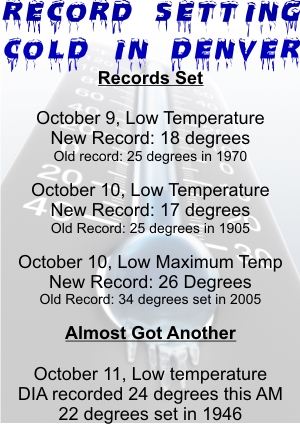
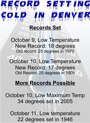
Following on two low temperature records Friday and Saturday, a third was set Saturday when the mercury climbed to a high of only 26 degrees. That easily smashed the previous record low maximum for the date of 34 degrees set in 2005.

Friday night the cold front moved in and temperatures plummeted 23 degrees in five hours. Before midnight the mercury read 18 degrees thus shattering the old low temperature record for October 9th of 25 degrees. That record dated to 1970.

Saturday morning the low temperature at Denver International Airport dropped to 17 degrees. That set a new record low temperature for October 10th as well. The previous record low of 25 degrees was set more than a century ago in 1905.

A fourth record, for Sunday’s low temperature, was within reach but the mercury didn’t quite dip far enough. The record low for the date is 22 degrees, set in 1946. This morning the temperature at DIA dropped to 24 degrees which while chilly, didn’t quite go far enough.

The Arctic blast of cold air sent temperature plunging and forced the postponement of game 3 of the National League Divisional Series against the Colorado Rockies and Philadelphia Phillies. That game has been rescheduled for tonight at 8:07pm.

Sunday will be the first time since Friday night with temperatures above the freezing mark in Denver although it will remain 20 degrees cooler than normal. The forecast high today is 49 degrees whereas the average for this date is 69 degrees.

For the Rockies game, at the first pitch the temperature will be around 38 degrees. The mercury will slowly drop during the game and be down to around 35 by 11:00pm.

Denver BroncosThe Rockies aren’t the only game in town today either. The Denver Broncos host the New England Patriots at 2:00pm. For the game at Invesco Field at Mile High, it should be great football weather. It will be 47 degrees at kickoff and remain right in that vicinity throughout. A slight breeze around 5 mph will make it feel a touch cooler than that.
For the longer term, temperatures throughout the week will remain cooler than normal. Columbus Day temps will actually be a touch cooler than today before we start a slight warm-up for the rest of the week.

October 11 to October 17 – This week in Denver weather history

October 11 to October 17 - This week in Denver weather history

A very eventful week of weather in Denver weather history.  Many notable items have occurred and many also incorporate one of two conditions – wind or snow.  Probably the most famous event was the Bronco Blizzard on October 15, 1984.  That storm which hit its height during a Monday Night Football game between the Broncos and the Packers is probably one of the most memorable ever for longtime Denver residents.

10-11

In 1986…the first significant snowstorm of the season produced 2 to 5 inches of snow over metro Denver with 5 to 10 inches in the foothills west of Denver.  Wondervu recorded the most snow from the storm…13 inches.  The heavy wet snow caused numerous power outages.  The storm was accompanied by strong north winds with gusts to 41 mph recorded on the 10th.  The first snowfall of the season totaled 3.1 inches at Stapleton International Airport with only one inch on the ground due to melting.  The strong cold front accompanying the storm cooled the temperature from a high of 73 degrees on the 10th to a high of only 33 degrees on the 11th…which was a record low maximum for the date.

10-12

In 1969…the second heavy snowstorm in less than a week dumped nearly a foot of snow across metro Denver and plunged the area into extremely cold temperatures for so early in the season.  Snowfall totaled 11.0 inches at Stapleton International Airport.  North winds gusting to 26 mph produced drifts up to 2 feet deep.  Temperatures dipped from a high of 52 degrees on the 10th to a record low for the date of 10 degrees on the 12th.  There was additional damage to trees and power and telephone lines from heavy snow accumulations and icing.  Travel was restricted or blocked by drifting snow in both the mountains and on the plains east of Denver.

11

In 1997…damaging winds ahead of an approaching storm system developed in the foothills and spread across metro Denver. Winds gusted to 88 mph at Conifer…71 mph at the National Center for Atmospheric Research on the mesa in Boulder… And 53 mph at Denver International Airport.  Several trees and street signs were blown down with scattered power outages reported throughout metro Denver.  In Arvada…a car window was blown out by a strong wind gust.

11-12

In 1901…an apparent cold front produced northeast winds sustained to 42 mph with gusts to 48 mph on the 11th. General rain changed to snow overnight and totaled 2.0 inches.  This was the first snowfall of the season. Total precipitation was 0.32 inch.

Continue reading October 11 to October 17 – This week in Denver weather history

Denver breaks 104 year old cold temperature record as Arctic chill sets in

Record setting cold temperatures arrive in DenverThe Arctic blast of cold air that has settled in across much of the nation’s midsection arrived in Colorado Friday night and allowed the Mile High City to set two low temperature records. Two more records may be set today and tonight before we start to warm up on Sunday.

Friday night the cold front moved in and temperatures plummeted 23 degrees in five hours. Before midnight the mercury read 18 degrees thus shattering the old low temperature record for October 9th of 25 degrees. That record dated to 1970.  Thornton was a touch warmer than the official station at DIA as we recorded a low of 19.7 yesterday.

This morning the low temperature at Denver International Airport has dropped to 17 degrees. That sets a new record low temperature for October 10th as well. The previous record low of 25 degrees was set more than a century ago in 1905.  At ThorntonWeather.com we have been a bit chillier having recorded a low of 16.3 degrees this morning. 

The forecast for today and tonight also portends the potential to set two more cold temperature records.

  • The record low maximum temperature for today is 34 degrees, set in 2005. With temperatures today forecast to struggle to get above freezing, that could be the third record set.
  • Lastly, a fourth record is possible and indeed, quite likely. The record low temperature for the 11th of October (Sunday) is 22 degrees set in 1946. Current forecasts put the overnight low Saturday night / Sunday morning as possibly hitting down the mid to upper teens thus setting up the potential to break that record.

That would be four record setting cold temperature records in a 48 hour span!

Related – Examiner.com:

Record setting cold may be on the way

As the Colorado Rockies return home to play game 3 of the National League Divisional Series against the Philadelphia Phillies, the weather could prove to be a tougher opponent than the opposing team. As we forecast early this week, a major blast of Arctic air will be arriving over Colorado tonight and will send thermometers plunging, possibly into record setting territory.

Over the next 48 hours, Denver could break three, very chilly records:

  • The record low temperature for Denver on the 10th of October (Saturday), the day of the game, is 25 degrees. That was set more than 100 years ago in 1905.  Tonight’s / tomorrow morning’s forecast low temperatures are expected to be in the low 20’s.
  • The record low maximum temperature for the 10th is 34 degrees, set in 2005. Tomorrow’s forecast high temperature is expected to be in the mid 30’s.
  • The record low temperature for the 11th of October (Sunday) is 22 degrees set in 1946. Current forecasts put the overnight low Saturday / Sunday morning as possibly hitting down to 17 degrees.

Of the three, it seems pretty likely we will break the first and the third record listed. The second one is a bit up in the air.

There's more to this story on the Denver Weather Examiner's site!For a detailed look at what the weather forecast holds for the Rockies and Phillies, check out our forecast at Examiner.com.

The Natural Disasters Examiner – The place for all the latest on the events that affect us all

The Natural Disasters Examiner provides news, information and education on disasters across the globe.

Following on our announcement of our writing the Climate Change Examiner, we are pleased to announce that we are now also writing the Natural Disasters Examiner.  From earthquakes to tsunamis and hurricanes to tornadoes the Natural Disaster Examiner covers natures events that affect all of our lives.

We cover these type of events on a local scale here on ThorntonWeather.com and in our Denver Weather Examiner pages.  However, the Natural Disasters Examiner expands that scope to include the globe. 

We will examine all natural disaster type events no matter where they occur and we will provide more than just the news.  On the Natural Disasters Examiner’s site we will provide education on the science behind these disasters and practical information on how you can protect yourself and your family. 

We encourage you to check out the Natural Disasters Examiner on Examiner.com by clicking here. 

We also have provide links to it and the Denver Weather Examiner and Climate Change Examiner below the menu on the left.