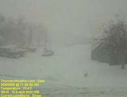
The March Blizzard of 2009 is winding down and it gives us a chance to look at all that happened in the last 36 hours or so. One of the neat things to look at is the 24 hour time lapse video from yesterday. Check out the video from our two webcams:
On March 28th at 8:30pm local time, cities across the globe will participate in Earth Hour by turning off their lights for one hour. More than 1,500 cities around the globe have committed to taking the measure to highlight worries about climate change. U.N. Secretary-General Ban Ki-moon has asked for support for the endeavor saying,”It promises to be largest demonstration of public concern about climate change ever attempted.”
Organized by the World Wildlife Fund (WWF), last year’s event saw an estimated 50 million people worldwide participate. Organizers hope for a much more significant event this year with a goal of 1 billion as a way to ‘send a strong message to our political leaders that we want them to take meaningful action on climate change.’
Acknowledging that the event will not do anything to decrease the world’s carbon footprint, the WWF likens it to other symbolic events such as the Boston Tea Party or the protests of the 1960’s.
I urge citizens everywhere to join us. We are on a dangerous path, the planet is warming and we must change our ways.
– U.N. Secretary-General Ban Ki-moon
Berlin, Beijing, Copenhagen, Dubai, Hong Kong, London, Mexico City, Moscow, Paris, Sydney and Toronto are some of the international cities that have committed to participate. Here in the United States many major cities have agreed to turn their lights out including Albuquerque, Boston, Chicago, Dallas, Las Vegas, Los Angeles, New York, Washington D.C. and more.
Colorado as well has six cities participating including Boulder, Commerce City, Denver, Fort Collins, Silverthorne, and Westminster. Denver will darken four public buildings: the Wellington Webb Building, the City and County Building, the Human Services Building on Federal Boulevard and the McNichols Building.
The city has annnounced that they will be plowing residential streets in accordance with their snow removal plan.
From the City of Thornton:
City of Thornton officials have rated this a Class 3 storm (potential to last more than 24 hours; accumulations of over nine inches) and are treating it as such. This means that the city is bringing in on-call contractors to supplement the city truck efforts. While City Crews are staying on arterials, contractors have plowed secondary streets and are commencing plowing operations in residential neighborhoods.
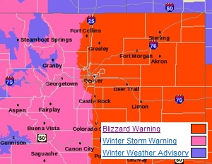
Thornton and Denver are preparing for what will be its biggest snowstorm of the season today as the National Weather Service has now issued a Blizzard Warning for all of eastern Colorado. The major storm we had been watching in recent days is now arriving over the Front Range and snow is starting to fall and will become widespread by 7:00am. Initially the snow will melt as it hits the ground but as it gets heavier, it will begin to accumulate.
March is our snowiest month and this is setting up to be a classic late winter / early spring storm with lots of Pacific moisture and a Canadian cold front dipping down from the north. Winds are now starting to come out of the east and northeast providing the required upslope conditions that will slow the storm down and hold it over the Front Range.
Between noon and about 9:00pm the snow will be at its heaviest as will the wind which will cause significant drifting and road travel will become treacherous – the afternoon rush hour is almost certainly going to be a big mess. Road closures are likely to happen at some point later today, particularly south and east. Areas along the Palmer Divide, the foothills and the south metro area will have the most snow with lower amounts as you move north. The Denver metro area can look for snowfall totals between 8 and 16 inches while there could be up to two feet of snow in areas south and west.
Remember, a Blizzard Warning means that severe conditions are expected and winds can gust in excess of 35 mph coupled with significant snowfall. Visibilities may be reduced to a quarter of a mile or less and travel will be extremely dangerous and is discouraged. Be sure you are prepared if you do travel and should you get stranded, stay with your vehicle – do not head out and seek help! Going through these storms is always a major task. We ask that you please be careful if you are on the roads and if you have folks in your area that need a bit of help digging out, lend them a hand.
Since January, Denver has had 15% of its normal precipitation and for the snow season we are at a mere 41%. While the snow will be troublesome, we are truly in need of moisture so this is a welcome sight in some respects.
The major winter storm we have been tracking for the last couple of days continues on its path toward Denver and the Front Range and before it is over, Denver could see more than a foot of snow. The latest computer models indicate the storm is coming a bit further north than previously thought which increases the changes for what will be a very significant snow event for us.
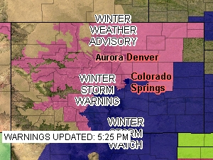
Snow in the mountains tonight will begin to spread to Denver and the Front Range Thursday morning and it will last through Thursday evening and beyond. Highlighting the significance of the storm, the National Weather Service has issued a Winter Storm Warning (see below for text of warning) for all of northeastern Colorado including Denver.
The NWS is forecasting snow totals from 8 to 15 inches for the metro area (see image below) and from 1 to 2 feet along the Palmer Divide. I think that may be a bit optimistic myself but there is little doubt we are in for our biggest storm of the snow season. Areas south and west like Highlands Ranch, Parker and Golden will almost certainly experience the most snow in the metro area. See the image below for potential snow totals.
The National Weather Service has issued a Winter Storm Warning for Denver and much of northeastern Colorado in anticipation of a significant storm now approaching the state. The warning takes the place of the previously issued watch and signifies the increased potential for a major snow event. The warning goes into effect at 6:00am Thursday morning and runs through 6:00am Friday.
Computer models are beginning to coalesce around solutions that involve snow amounts that could exceed a foot along the Palmer Divide and the foothills. Snow will begin falling in the foothills in the morning and by midday will encompass the entire Front Range. By the time the storm ends, much of the metro area will have in excess of six inches of snow. Tomorrow afternoon’s commute is almost certainly going to be a rough one.
The spring snowstorm could be our biggest storm to date for the 2008 – 2009 winter season. We are desperately in need of moisture so while it may be troublesome, we really need the precipitation.
This week in Denver weather history are a number of interesting events. As March comes to a close we are not yet done with winter so snow is certainly still possible but we also start seeing more Spring-like weather. Reminders of this include the coldest temperature ever recorded in March – 11 degrees below zero 123 years ago. Conversely, 38 years ago the highest temperature ever recorded in March of 84 degrees was recorded.
20-22
In 1944…heavy snow fell over metro Denver for a total of 36 hours. The storm dumped 18.5 inches of snowfall over downtown Denver and 12.2 inches at Stapleton Airport. Fortunately…there were no strong winds with the storm. North winds to only 19 mph were recorded on the 21st.
21-22
In 1955…wind gusts to 98 mph were recorded at rocky flats south of Boulder. Some damage and a few minor injuries were reported in Boulder. Northwest winds were sustained to 28 mph with gusts to 39 mph at Stapleton Airport on the 22nd.
In 1966…a vigorous cold front produced only 1.7 inches of snowfall at Stapleton International Airport…but northeast winds gusted to 49 mph on the 21st. Temperatures cooled from a maximum of 66 degrees on the 21st to a minimum of 14 degrees on the 22nd. Strong winds occurred on both days.
In 1992…an arctic cold front produced upslope snow across metro Denver mainly west of I-25. Castle Rock reported 6 inches of snow with 3 inches at Evergreen. At Stapleton International Airport…only 1.5 inches of snowfall were measured and northeast winds gusted to 18 mph on the 21st.
Researchers at Florida State University announced that global hurricane activity continues to decrease and is now at levels not seen since 1977. The researchers say that, “Tropical cyclone (TC) activity worldwide has completely and utterly collapsed during the past 2 to 3 years.”
Using a measurement called the Accumulated Cyclone Energy index (ACE), researchers see a tremendous drop in cyclone energy for the globe as a whole. While the north Atlantic saw above normal levels of ACE in 2008, it represents a relatively small amount of the global hurricane energy and as such cannot compensate for the much reduced levels elsewhere on Earth.
Just as there are active periods of hurricane activity around the globe, there are inactive periods, and we are currently experiencing one of the most impressive inactive periods, now for almost 3 years.
– Florida State University researchers
You can find complete coverage of this story as well as an incredible slideshow of hurricanes as seen from space on our Examiner.com weather news page. Click here to go there.
This week is Denver and Thornton weather history is notable for many reasons. 2003 stands out as an extremely eventful year this week in weather history. From March 17th to the 19th, six years ago, Denver was hit by one of its largest snowstorms in history. We actually recently wrote about this storm on Examiner.com – click here to see it. Also, we see our first mention of a tornado for the year, also in 2003, on March 17th. The twister hit near Strasburg but was short-lived and caused no damage. These events serve as a reminder that winter is not over and severe weather can strike at any time.
9-19
IN 1906…AN EXTENDED COLD AND BLUSTERY PERIOD OCCURRED WITH LIGHT SNOW TOTALING 14.4 INCHES OVER 11 CONSECUTIVE DAYS. THE GREATEST AMOUNT OF SNOW ON A SINGLE DAY WAS 4.0 INCHES ON THE 15TH. ONLY A TRACE OF SNOW FELL ON THE 12TH AND 17TH. HIGH TEMPERATURES WERE BELOW FREEZING FOR THE ENTIRE PERIOD. THE COLDEST WERE 14 DEGREES ON THE 16TH AND 18 DEGREES ON THE 17TH. BOTH READINGS WERE RECORD LOW MAXIMUMS FOR THE DATES. LOW TEMPERATURES WERE MOSTLY IN THE SINGLE DIGITS. THE COLDEST WERE 2 DEGREES BELOW ZERO ON THE 16TH AND 5 DEGREES BELOW ZERO ON THE 19TH. NORTHEAST WINDS WERE SUSTAINED TO 22 MPH ON THE 9TH. NORTH WINDS WERE SUSTAINED TO 36 MPH ON THE 10TH…32 MPH ON THE 13TH… AND 22 MPH ON THE 15TH.
12-16
IN 1880…A PROTRACTED COLD SPELL RESULTED IN 8 TEMPERATURE RECORDS BEING SET. RECORD LOW TEMPERATURES FOR THE DATE WERE SET WHEN THE TEMPERATURE DIPPED TO 10 DEGREES BELOW ZERO ON THE 13TH AND 14TH…8 DEGREES BELOW ZERO ON THE 12TH AND 15TH…AND 4 DEGREES BELOW ZERO ON THE 16TH. DAILY RECORD LOW MAXIMUM TEMPERATURES WERE SET WITH 11 DEGREES ON THE 12TH…12 DEGREES ON THE 13TH… AND 19 DEGREES ON THE 15TH.
13-15
IN 1906…SNOWFALL TOTALED 8.0 INCHES OVER DOWNTOWN DENVER.
14-16
IN 1908…A WARM SPELL RESULTED IN DAILY RECORD HIGH MINIMUM TEMPERATURES ON 3 CONSECUTIVE DAYS: 54 DEGREES ON THE 14TH…52 DEGREES ON THE 15TH…AND 56 DEGREES ON THE 16TH… ALSO THE ALL-TIME RECORD HIGH MINIMUM FOR THE MONTH OF MARCH. HIGH TEMPERATURES RANGED FROM 65 DEGREES ON THE 14TH TO 72 DEGREES ON THE 16TH.
IN 1983…A HEAVY WET SNOWSTORM BURIED METRO DENVER WITH THE FOOTHILLS RECEIVING THE MOST. CONIFER RECORDED 34 INCHES OF SNOW WITH 4 FEET MEASURED AT COAL CREEK CANYON IN THE FOOTHILLS NORTHWEST OF DENVER. THE STORM LEFT 6 TO 10 INCHES OF SNOW ACROSS METRO DENVER. BOULDER RECEIVED 12 TO 18 INCHES. FLIGHT OPERATIONS AT STAPLETON INTERNATIONAL AIRPORT WERE LIMITED TO ONE RUNWAY FOR A TIME. SOME ROADS AND SCHOOLS WERE CLOSED…AND POWER OUTAGES OCCURRED WHEN WET SNOW DOWNED LINES. SNOWFALL ON THE 15TH AND 16TH TOTALED 7.2 INCHES AT STAPLETON INTERNATIONAL AIRPORT WHERE NORTH WINDS GUSTED TO 30 MPH. MAXIMUM SNOW DEPTH ON THE GROUND WAS ONLY 6 INCHES DUE TO MELTING.
Schmitt recalled as a child in Silver City, New Mexico helping his father, also a geologist, take rain measurements. Those early experiments spurred the former astronaut’s interest in earth sciences at an early age. He recalled how later in life, while on the surface of the moon, he made weather forecasts for the southern hemisphere of the earth.
In wide ranging commentary, Dr. Schmitt made a point by point argument against many of the things that global warming advocates point to in support of the theory. In a similar vein to his comments last month, he continued to admonish scientists and politicians that have politicized the issue and said those that disagree do have a battle ahead of them.