All posts by Thornton Weather

ThorntonWeather.com is your local source for live Thornton, Colorado weather conditions and news!

February 1 to February 7 – This week in Denver weather history

February 1 to February 7 - This week in Denver weather history

A look back at this week in Denver weather history shows the wide variety of weather conditions that we can receive.  Everything from warm spring-like days to high speed damaging winds to protracted bone chilling Arctic cold spells is evident. 

26-1 

IN 1888…A PROTRACTED WARM SPELL LASTED A WEEK.  MAXIMUM TEMPERATURES RANGED FROM 62 DEGREES ON THE 29TH TO AN ALL TIME RECORD HIGH FOR THE MONTH OF 76 DEGREES ON THE 27TH.  DAILY RECORD HIGH TEMPERATURES OF 76…69… AND 71 OCCURRED ON THE 27TH…28TH… AND 30TH RESPECTIVELY. RECORD HIGH MINIMUM TEMPERATURES OF 47 AND 34 OCCURRED ON THE 26TH AND 27TH.

30-7 

IN 1985…A COLD FRONT ON THE 29TH PRODUCED A PROTRACTED COLD SPELL AS ARCTIC AIR REMAINED ENTRENCHED ACROSS METRO DENVER. WHILE THE ONLY DAILY TEMPERATURE RECORD SET WAS A LOW MAXIMUM READING OF 2 DEGREES ON FEBRUARY 3RD…MINIMUM TEMPERATURES PLUNGED WELL BELOW ZERO ON 9 CONSECUTIVE DAYS. THE COLDEST READINGS WERE 15 DEGREES BELOW ZERO ON JANUARY 31ST AND 14 DEGREES BELOW ZERO ON FEBRUARY 5TH.

31-1 

IN 1963…HIGH WINDS STRUCK METRO DENVER.  THE STRONG CHINOOK WINDS REACHED 101 MPH IN LITTLETON…80 MPH IN DENVER…AND 90 MPH AT ROCKY FLATS.  AMONG THE HARDEST HIT AREAS WERE BOULDER WHERE BUILDINGS UNDER CONSTRUCTION WERE BLOWN DOWN…PORCHES AND ROOFS BLOWN OFF BUILDINGS… AND POWER LINES DAMAGED.  DAMAGE TOTALED 100 THOUSAND DOLLARS IN BOULDER ALONE.  IN OTHER AREAS…UTILITY LINES WERE DAMAGED AND MANY SIGNS…ANTENNAS… AND ROAD MARKERS WERE BLOWN DOWN.  AT STAPLETON AIRPORT…WEST WINDS GUSTED TO 44 MPH ON THE 31ST AND 66 MPH ON THE 1ST.  THE CHINOOK WINDS WARMED MAXIMUM TEMPERATURES TO 65 DEGREES ON THE 31ST AND TO 70 DEGREES ON THE 1ST.

Continue reading February 1 to February 7 – This week in Denver weather history

A look at Super Bowl weather history and some interesting tornado statistics for it

The biggest sporting event of the year is of course the Super Bowl and no doubt this year’s matchup between the Pittsburgh Steelers and the Arizona Cardinals is sure to be no different.  Super Bowl XLIII will be held in Tampa Bay, Florida and the weather forecast is looking to be just about perfect – see our game day forecast below.

What about Super Bowl’s in the past?  Was there ever any notable weather during the big game?  You bet there was.  Here are some fun facts (courtesy wx-man.com):

  • 17 of 42 Super Bowls played indoors
  • 16 of 42 Super Bowls had a trace or more of rain nearby
  • 2 Super Bowls had snow on game day (1982,2006)
  • 1 Super Bowl played during an ice storm (2000)
  • Warmest high temperature of 82° (1973,2003)
  • Coldest high temp for dome game 16° (1982)
  • Coldest high temp for non-dome game 49° (1985)
  • Wettest Super Bowl .92 inches (2007)
  • Outside games with high wind gust (1980, 1984, 1989,2007)

You will notice there isn’t really any mention of severe weather in those statistics. The NFL has been pretty fortunate on that front with nothing particularly notable – rain always seems to be the biggest threat. 

For a more in depth look at severe weather in February in Florida, the Super Bowl forecast and some interesting tornado statistics, please visit our Examiner.com story.

For all the details, read the rest of this story on our Denver Weather Examiner page. Examiner.com - Get inside Denver weather 

Founder of The Weather Channel warns of ‘dramatic turn toward a colder climate’

John Coleman, founder of the Weather Channel, is an outspoken critic of the global warming theory.

John Coleman is the founder of The Weather Channel and an outspoken critic of the global warming theory.  In years past he has called global warming “the greatest scam in history” and has called for suing Al Gore and others that hype the theory in order to force a debate on the merits of it. 

Coleman is now a meteorologist for KUSI in San Diego and yesterday he offered a story that he called, “The Amazing Story Behind the Global Warming Scam.”

As he has done in the past, Mr. Coleman advocates that global warming is a hoax and nothing more.  He says we have taken a “dramatic turn toward a colder climate. The last two bitter winters have lead to a rise in public awareness that CO2 is not a pollutant and is not a significant greenhouse gas that is triggering runaway global warming.”  

Mr. Coleman provides some interesting background on how former Vice President Al Gore came to become such an advocate for the manmade climate change theory. 

For all the details, read the rest of this story on our Denver Weather Examiner page. Examiner.com - Get inside Denver weather

Meteorologists know nothing about climate change

What do meteorologists know about climate change?

A pretty interesting headline isn’t that?  I admit that is probably a bit more sensationalistic than what is really called for. However, that would seem to be one of the conclusions from the author and analyst of a recent survey.

3,146 earth scientists from various areas of expertise were surveyed for their opinions and in many ways, the data was not surprising.  Two questions were key to the study:

Have mean global temperatures risen compared to pre-1800s levels?

Has human activity been a significant factor in changing mean global temperatures?

For all the details, read the rest of this story on our Denver Weather Examiner page. Examiner.com - Get inside Denver weather

January 25 to January 31 – This week in Denver weather history

January 25 to January 31 - This week in Denver weather history.

A very eventful week in Denver weather history.  Among the notable items – the longest period of snow on record, the highest wind gust ever in the metro area (147mph) and numerous blizzards that caused a variety of problems.

22-26

IN 1948…THE LONGEST PERIOD OF SNOWFALL ON RECORD (92 HOURS AND 3 MINUTES) OCCURRED IN DOWNTOWN DENVER WHERE A TOTAL OF 13.6 INCHES OF SNOW FELL.  AT STAPLETON AIRPORT…19.0 INCHES OF SNOW FELL…MAKING IT THE HEAVIEST SNOW IN JANUARY AND THE 5TH HEAVIEST SNOW OF RECORD AT THAT TIME.  NORTH WINDS WERE SUSTAINED TO A VELOCITY OF 23 MPH ON THE 25TH…BUT GENERALLY THE WINDS WERE LIGHT THROUGHOUT THE STORM.  THE SNOW DISRUPTED TRAFFIC…BUT STREET CLEARING WAS BEGUN SOON AFTER IT BECAME APPARENT THAT THE SNOW WOULD BE HEAVY.  OVER THE 5 DAYS…TEMPERATURES RANGED FROM A HIGH OF 48 DEGREES ON THE 22ND TO A LOW OF 1 DEGREE ON THE 26TH.  MOST READINGS WERE IN THE TEENS AND 20`S DURING THE STORM.

24-25

IN 1916…A TRACE OF LIGHT RAIN…RARE IN DENVER FOR JANUARY…  OCCURRED ON BOTH DAYS.
 
IN 1946…HIGH WINDS OCCURRED IN BOULDER AND ALONG THE FOOTHILLS TO THE NORTH.  A WIND GUST TO 72 MPH WAS RECORDED AT VALMONT.
 
IN 1947…STRONG WINDS WERE MEASURED IN BOULDER.  HOURLY WIND GUSTS AVERAGED 72 MPH AT VALMONT EAST OF BOULDER.
 
IN 1950…HEAVY SNOWFALL TOTALED 7.1 INCHES AT STAPLETON AIRPORT AND 6.8 INCHES IN DOWNTOWN DENVER.

Continue reading January 25 to January 31 – This week in Denver weather history

Antarctica is warming like the rest of globe – or not

This illustration depicts the warming that scientists have determined has occurred in West Antarctica during the last 50 years, with the dark red showing the area that has warmed the most.  Image:  NASA
This illustration depicts the warming that scientists have determined has occurred in West Antarctica during the last 50 years. Image: NASA

In all the talk about global warming and manmade climate change, one thing that was always missing from the discussion was any talk about Antarctica.  The continent on the bottom of the world was not fitting the pattern that global warming advocates were seeing – it simply wasn’t getting warmer there.  In fact, it seemed to actually be getting cooler.

A new study released in the latest issue of Nature challenges the facts though as we understood them.  By going further than previous work and using satellite data, the study claims that Antarctica in fact has been warming – we just didn’t know it.  Satellites proved useful in coming to the study’s conclusions and filling in gaps because the continent, which is twice the size of the United States, has few monitoring stations in its interior.

The problem with this claim?  It looks like not everyone agrees on the methods the authors used.  Even those that are firm believers in the manmade climate change theory aren’t so sure this study is accurate!

For all the details, read the rest of this story on our Denver Weather Examiner page. Examiner.com - Get inside Denver weather

Global warming supercomputer emits as much CO2 as 2,400 homes

The polar bears won't be happy!  New UK climate change computer emits as much CO2 as 2,400 homes.
The polar bears won't be happy! New UK climate change computer emits as much CO2 as 2,400 homes.

In a bit of an embarrassment for the UK Met Office (the equivalent to our National Weather Service), it was discovered that a new supercomputer they have to calculate the effects of climate change emits 14,400 tons of CO2 a year. As reported by TimesOnline, that is the same amount of CO2 that 2,400 homes emit in an entire year.

The Met Office has justified the use of the super-polluting computer saying that the work done on it saves more CO2 than it uses. The Met Office Director of Science and Technology is quoted as saying, “We recognize that running such massive computers consumes huge amounts of power and that our actions in weather and climate prediction, like all our actions, have an impact on the environment. We will be taking actions to minimize this impact.” At a cost of £33m ($45 million USD), the new computer isn’t cheap either!

For all the details, read the rest of this story on our Denver Weather Examiner page. Examiner.com - Get inside Denver weather

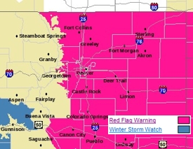
Red Flag Warning in effect for Denver and the Front Range

A Red Flag Warning is in effect for Denver and the Front Range Thursday from 11:00am to 6:00pm.

While we have all enjoyed the record January warmth of recent days but that does come at a price.  The warm temperatures, dry wind and very low humidity have dried much of the area out to a dangerous state. 

Today we have one more warm day before we return to more seasonable weather.  With temperatures climbing into the 60’s, humidity as low as 5 percent and a west wind that will pick up later today, the fire danger is very real.  As we saw a couple weeks ago with the Olde Stage Road Fire, it doesn’t take much beyond a spark to set off a fire that can spread very quickly with as dry as it is.
 
The potentially dangerous conditions have caused the National Weather Service to issue a Red Flag Warning that will be in effect from 11:00am today through 6:00pm this evening. 

Red Flag Warning
National Weather Service, Denver
544 am MST THU JAN 22 2009

……Red Flag Warning today from 1100 to 1800 MST…for Front Range foothill zones 215 and 216 below 8000 feet…and for the I-25 urban corridor zones 238..239..240 and 241 in northeast Colorado…

One more day of unseasonably warm and very dry conditions will be accompanied by periods of gusty Chinook winds resulting in critical wildland fire conditions in and near the front range foothills in northern Colorado. Minimum relative humidities will range from 5 to 15 percent with maximum temperatures in the 60 to 70 degree range. This is as much as 25 degrees above average for the date. Furthermore west winds in and near the foothills are expected to increase later the morning…with gusts this afternoon to 40 mph in the foothills and to 30 mph on the nearby plains.

Fuels are also quite dry in the area with no precipitation in the area for some time. These critical wildland fire conditions are expected to improve this evening with dry downslope winds subsiding…and a shift to a more humid east wind overnight with a weak cold front backing into northeast Colorado.

…Red Flag Warning in effect from 11 am this morning to 6 pm MST this afternoon…

The National Weather Service in Denver has issued a Red Flag Warning…which is in effect from 11 am this morning to 6 pm MST this afternoon.

Unseasonably warm temperatures…gusty west winds and very low relative humidities will combine with very dry fuels to produce critical wildland fire conditions in and near the Front Range foothills late this morning through this afternoon. Foothill areas below 8000 feet and lower elevations west of I-25 are more likely to see these conditions develop.

Get more local news and weather information on Examiner.com.

This article and many more are posted to the Denver Weather Examiner site.

Visit Examiner.com for more local Denver news and weather.

A Red Flag Warning means that critical fire weather conditions are either occurring or imminent. Please advise the appropriate officials and fire crews in the field of this Red Flag Warning.

Denver officially breaks high temperature record for this date

Denver officially broke the record high temperature for January 21st, reaching 71 degrees.

It’s official. As reported earlier this morning on our Examiner.com pages, we had a decent shot at breaking the all time record high temperature for this date and we have done it.  At 1:28pm today the temperature at Denver International Airport reached 71 degrees, breaking the old record of 70 degrees set in 1950.  Here in Thoronton we didn’t get quite that warm, “only” reaching a high of 69 degrees.

Thursday we will be a bit cooler and “only” reach 65 degrees – still 20 degrees above normal though.  Enjoy the next 36 hours or so though as Friday bring change – see our Examiner.com morning forecast here for details.

Get more local news and weather information on Examiner.com.

This article and many more are posted to the Denver Weather Examiner site.


Visit Examiner.com for more local Denver news and weather.

January 18 to January 24 – This week in Denver weather history

January 18 to January 24 - This week in Denver weather history.

Our look back in Denver weather history for this week is dominated by the seemingly ever present high winds.  There are numerous incidents of those causing damage and injury.  Also notable though was a snowstorm in 1948 that dumped snow for more than 92 hours straight, a protracted cold spell in 1962 that lasted nearly a week and claimed lives and more recently the snowstorms in January 2007 that dumped snow on the region.

14-21

IN 1930…A PROTRACTED COLD SPELL OCCURRED WHEN LOW TEMPERATURES PLUNGED BELOW ZERO ON 8 CONSECUTIVE DAYS.  THE COLDEST LOW TEMPERATURES OF 20 DEGREES BELOW ZERO ON THE 17TH AND 19 DEGREES BELOW ZERO ON THE 16TH WERE RECORD MINIMUMS FOR THE DATES.  HIGH TEMPERATURES DURING THE PERIOD RANGED FROM 18 ON THE 18TH TO ZERO ON THE 20TH.  TWO DEGREES ON THE 15TH WAS A RECORD LOW MAXIMUM TEMPERATURE FOR THE DATE.

15-23

IN 1962…A PROTRACTED COLD SPELL KEPT METRO DENVER IN THE DEEP FREEZE FOR MORE THAN A WEEK.  FROM THE 15TH THRU THE 23RD…LOW TEMPERATURES WERE ZERO OR BELOW FOR 9 CONSECUTIVE DAYS…BUT A DAILY RECORD LOW WAS SET ONLY ON THE 22ND WHEN THE TEMPERATURE DIPPED TO 14 DEGREES BELOW ZERO.  A RECORD LOW MAXIMUM FOR THE DATE WAS ALSO SET ON THE 22ND WHEN THE TEMPERATURE CLIMBED TO ONLY 11 DEGREES.  THE COLDEST HIGH TEMPERATURE WAS 3 DEGREES ABOVE ZERO ON THE 21ST…WHICH DID NOT BREAK THE RECORD.  THE PROTRACTED COLD WAS BROKEN FOR ONLY A FEW HOURS ON THE AFTERNOON OF THE 20TH WHEN CHINOOK WINDS WARMED THE TEMPERATURE TO A HIGH OF 38 DEGREES BEFORE ANOTHER SURGE OF COLD ARCTIC AIR PLUNGED TEMPERATURES BACK INTO THE DEEP FREEZE THAT EVENING.  THE SEVERE COLD CAUSED MUCH DAMAGE TO WATER SYSTEMS.  A WOMAN WAS FROZEN TO DEATH AT MORRISON.  THERE WERE OTHER DEATHS ATTRIBUTABLE TO THE WEATHER…INCLUDING TRAFFIC DEATHS AND HEART ATTACKS FROM OVEREXERTION.

16-18

IN 1943…LIGHT SNOWFALL TOTALED 3.2 INCHES OVER THE 3 DAYS. THIS WAS THE ONLY MEASURABLE SNOW OF THE MONTH.  NORTH WINDS WERE SUSTAINED TO 20 MPH ON THE 16TH.

17-18

IN 1974…RARE OVERNIGHT JANUARY RAINFALL TOTALED 0.12 INCH ON THE 17TH AND 0.26 INCH ON THE 18TH WHEN IT WAS BRIEFLY MIXED WITH SNOW.

Continue reading January 18 to January 24 – This week in Denver weather history