![]() After having showers on and off Monday, Tuesday shapes up to be the nicest day of the week. It will be mostly sunny with slightly below normal temperatures today. We then return to an unstable pattern for the rest of the work week beginning Wednesday. Showers will be present the better part of Wednesday, changing to a rain / snow mix into Wednesday night. By Thursday we will see mostly sporadic snow showers. Actual amounts of precipitation vary widely between the models – some calling for 0.1″ to 0.5″ of precipitation, others 0.5″ to 1″. We’ll know more as we move through the week and everything sets up.
After having showers on and off Monday, Tuesday shapes up to be the nicest day of the week. It will be mostly sunny with slightly below normal temperatures today. We then return to an unstable pattern for the rest of the work week beginning Wednesday. Showers will be present the better part of Wednesday, changing to a rain / snow mix into Wednesday night. By Thursday we will see mostly sporadic snow showers. Actual amounts of precipitation vary widely between the models – some calling for 0.1″ to 0.5″ of precipitation, others 0.5″ to 1″. We’ll know more as we move through the week and everything sets up.
All posts by Thornton Weather
Nice Weekend Ahead
![]() The storm that moved through the Front Range yesterday really didn’t yield much for Thornton with a mere 0.03″ of precipitation. Areas farther south in the metro area saw quite a bit more; our sister station in Arvada had 0.16″ by contrast. We did also see a little bit of cloud to cloud lightning picked up on our lightning detector which serves as a reminder that thunderstorms will be here soon.
The storm that moved through the Front Range yesterday really didn’t yield much for Thornton with a mere 0.03″ of precipitation. Areas farther south in the metro area saw quite a bit more; our sister station in Arvada had 0.16″ by contrast. We did also see a little bit of cloud to cloud lightning picked up on our lightning detector which serves as a reminder that thunderstorms will be here soon.
Look for temperatures today (Friday) to be near 60. Saturday looks to be the warmest day with a high near 65 but it will be breezy and will cool quickly in the afternoon as a minor disturbance moves through the area. Sunday will be much like today. Further ahead, a front arriving on Monday could bring precipitation to the lower elevations here on the plains although the best chance for moisture right now looks to be in the mountains.
Rain & Snow Mix Today
![]() The storm for today didn’t quite set up as expected so its arrival was delayed and we aren’t expecting quite as much out of it at this point. At this time Thornton is seeing primarily rain showers with a few snow flakes mixed in. That rain and snow mix will continue off and on throughout the day and we could see some minor accumulations of snow on grassy areas but that will melt quickly. The weekend is still looking to be great with temperatures slightly above normal getting into the low 60’s.
The storm for today didn’t quite set up as expected so its arrival was delayed and we aren’t expecting quite as much out of it at this point. At this time Thornton is seeing primarily rain showers with a few snow flakes mixed in. That rain and snow mix will continue off and on throughout the day and we could see some minor accumulations of snow on grassy areas but that will melt quickly. The weekend is still looking to be great with temperatures slightly above normal getting into the low 60’s.
Seasonal Wednesday, Changes Arrive at Night
![]() Wednesday should be a nice day with temperatures right around the average of 57 degrees. Change is in the air though as before midnight we should start seeing rain which will turn to snow as the temperature drops overnight. As Thursday dawns, we’ll have wet conditions with snow showers for a good part of the daylight hours and a high of around 40. Total accumulations for the event will range from an inch to three inches but with as warm as it has been the snow won’t stick to much beyond some on the grassy areas.
Wednesday should be a nice day with temperatures right around the average of 57 degrees. Change is in the air though as before midnight we should start seeing rain which will turn to snow as the temperature drops overnight. As Thursday dawns, we’ll have wet conditions with snow showers for a good part of the daylight hours and a high of around 40. Total accumulations for the event will range from an inch to three inches but with as warm as it has been the snow won’t stick to much beyond some on the grassy areas.
Friday and into the weekend look for seasonal temperatures and maybe above the average. All in all it should be a nice weekend. The first part of next week is still a bit muddled between the models with some showing a chance for precipitation on Monday and Tuesday. Stay tuned for more information as it gets closer.
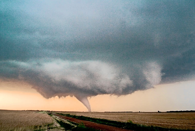
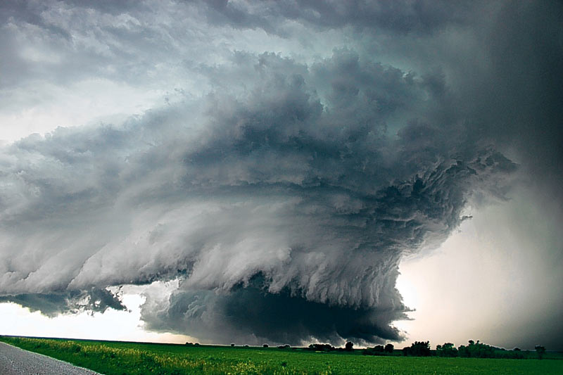
Adventures in Tornado Alley: The Storm Chasers
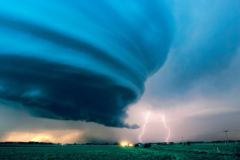
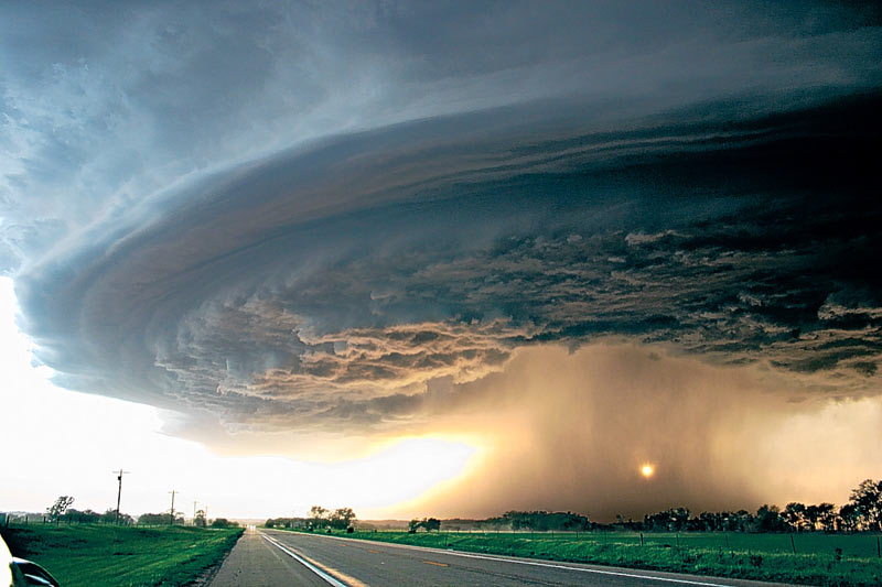
![]() I just read about this new book Adventures in Tornado Alley: The Storm Chasers. Most notably I saw some of the pictures in the book – absolutely incredible. See below. From Amazon’s description:
I just read about this new book Adventures in Tornado Alley: The Storm Chasers. Most notably I saw some of the pictures in the book – absolutely incredible. See below. From Amazon’s description:
The destructive power of nature has always been a source of fear and fascination, and never more so than now, when climate change and extreme weather conditions are constantly in the news. Across the central United States, the infamous storms of Tornado Alley are fueled by the collision of cold fronts from Canada and warm fronts from the Gulf of Mexico. People have been chasing these storms for decades in pursuit of thrilling experiences, but now a new generation of storm chasers is combining scientific knowledge with powerful images.
This book follows Mike Hollingshead and Eric Nguyen on seventeen chases through Colorado, Iowa, Kansas, Nebraska, New Mexico, Oklahoma, and South Dakota, illustrating the unfolding events with sequential shots and a running commentary by the chasers themselves. These spectacular storm portfolios are expanded with special features on weather phenomena like hail and mammatus clouds plus insights into forecasting and research. 340 color illustrations.
Definitely looks like a good one to check out! You can find it here on Amazon.com.
April Weather Preview – Something for Everyone
 April marks a transition between winter and summer for most of the country but for Denver it is especially true as we can see a stunning variety of weather. The proverbial April showers are certainly a possibility for Denver. Snow? Tornadoes? Thunderstorms? You bet – all can happen! For good measure throw in a chance for hail and even dust storms and April gives every type of weather condition you could like – or hate. Click here to read our April 2008 weather preview.
One Year Anniversary of Holly Tornado Marked Friday
![]() Friday marked the one year anniversary of the tornado that struck Holly, Colorado in Prowers County. At 8:11pm on March 28, 2007, with no real warning, an EF-3 tornado with winds of 165mph touched down and quickly tore a path more than two miles long and four blocks wide. 162 of the 369 homes in Holly were either damaged or destroyed but most notably, Rosemary Puga died during the storm and Delores Burns died a month later due to the injuries she suffered.
Friday marked the one year anniversary of the tornado that struck Holly, Colorado in Prowers County. At 8:11pm on March 28, 2007, with no real warning, an EF-3 tornado with winds of 165mph touched down and quickly tore a path more than two miles long and four blocks wide. 162 of the 369 homes in Holly were either damaged or destroyed but most notably, Rosemary Puga died during the storm and Delores Burns died a month later due to the injuries she suffered.
Today Holly is rebuilding and showing the American spirit of survival that has been demonstrated so many times in our country’s history. From the ashes of pain, suffering and destruction a new Holly is rising today but it serves as a reminder of the destructive power of Mother Nature. Here in Colorado we can see the entire gamut of severe weather and while we talk about the weather every day, we should always remember that it is not us who is in control and lives can be lost.
Please take a moment to say a prayer for Rosemary, Delores and all of the residents of Holly.
Space Station to be Visible in Denver
![]() For the next few days residents of the Denver area will be able to get a glimpse of the space station over the southern skies. Tonight it will be visible starting at 7:56pm in the south-southwest sky, about 10 degrees above the horizon. That is pretty low but come Friday and Sunday the angles are a bit higher. Be sure to check it out!
For the next few days residents of the Denver area will be able to get a glimpse of the space station over the southern skies. Tonight it will be visible starting at 7:56pm in the south-southwest sky, about 10 degrees above the horizon. That is pretty low but come Friday and Sunday the angles are a bit higher. Be sure to check it out!
Station viewing opporunities from Denver.
Station viewing opportunities from other places in Colorado.
Surprise Snow on Easter Eve
 Last night / this morning we had a bit of a surprise as the forecasted snow that was only supposed to amount to 1/2 inch quickly turned into 3.7 inches on the ground early this morning. Yesterday afternoon and early evening we started observing some upslope conditions with strong winds from the northeast and begain wondering if the passing front could bring more than forecast. The snow started falling in earnest around 8:00pm, tapered off around 9:30 then at 12:30 this morning more started falling. All in all a pleasant surprise.
For Easter morning things will be a bit chilly, particularly for those heading to sunrise services. Sunrise is at 6:57am and in Thornton at that time the mercury will be a mere 23 degrees. We’ll have clear skies today though and warm up pretty quickly to 43 by noon as we head for a high of 51. For the first part of the week we will see above normal temperatures in the upper 60’s Monday through Wednesday which is great for those on Spring Break this week.
We here at ThorntonWeather.com wish you and yours a happy and blessed Easter!
NOAA: Increased Flood Risk, Minimal Drought
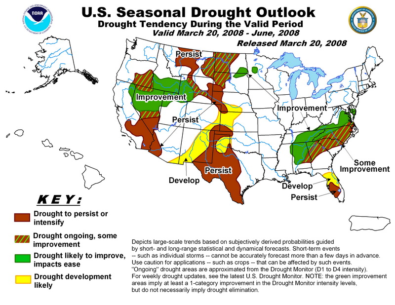
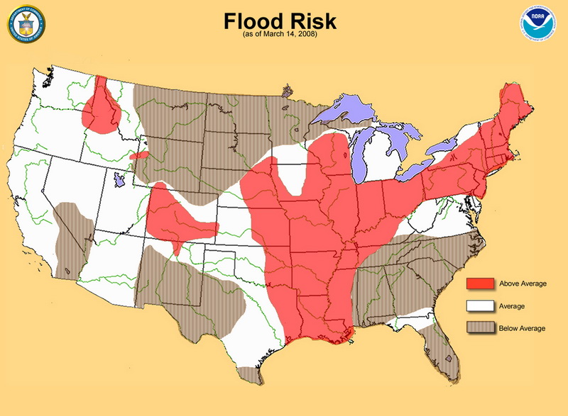
Yesterday NOAA released its spring drought and flood risk predictions and in it are some good and bad news for Colorado.
 First, the good news. With the extraordinary amount of snow the mountains have experienced this winter, the chances of drought are negligible for most of the state. The southeastern corner of Colorado however could see some risk.
Second, the bad news. With all that snow comes a risk of flooding. The danger could be especially great if we experience a warmer than normal spring and the mountain runoff occurs too quickly. Most of the state, with the exception of the northeast corner, runs above normal risks of flooding this spring. Locations in the mountains of Colorado have 150 to 200 percent of average water contained in snowpack leading to a higher than normal flood potential. Flooding is the number one weather killer in the country so everyone needs to be aware of the dangers this presents!
For more information, please see NOAA’s report here.