All posts by Thornton Weather

ThorntonWeather.com is your local source for live Thornton, Colorado weather conditions and news!

Fast Moving Storm Dumps 1.5″ of Snow

Snow!Much to everyone’s surprise, what was forecast to be not much more than a dusting of snow turned into quite a bit more.  In Thornton from about 6:00pm to 7:00pm we saw 1.5″ fall very quickly with near blizzard conditions for that brief period.  Much of the Denver metro area saw more snow than that, primarily west of I-25 and south of I-70.  Not far from us Broomfield reported 3.4″ and Federal Heights 3″.

Why did this storm offer more than predicted?  Here is what 7News’ meterologists offer:

Computer models had shown little if any snow across Denver.  However, instability in the atmosphere provided enough juice for a convective-type snowfall.  Reports of thundersnow came from southwest Denver near Chatfield State Park as a result of the instability early Wednesday afternoon.

This type of snow is called CSI, Conditional Symmetric Instability. It is generated when enough instability exists in the atmosphere to give snow showers a thunderstorm-type development.  With help from upslope flow, these snow events can dump a lot of snow in a short period of time.  While these events don’t last more than a few hours in most cases, snowfall rates as high as 2 to 3 inches can amount to excessive accumulation.

For the foreseeable future we expect to stay pretty dry.  Our next chance for snow comes Monday and into Tuesday.  No predictions yet on amounts of snow as it is too far out and the models aren’t consistent yet.  Until then, temperatures should be pretty seasonable.

Latest Snowpack Reports Continue to Hold Promise

Snowpack above normalSnowpack reports as of this morning continue to hold great promise for Colorado.  All of the major basins are above average with the exception of the South Platte.  Another major snowstorm is hitting the mountains today and yet another is forecast for Wednesday.  We can only hope this pattern continues and NOAA’s forecasts of a dry first quarter don’t hold true.

It would however be nice if some of that moisture would move out onto the front range and into the Denver area and the plains.  There is a chance for a bit of snow in the metro area tomorrow and again on Wednesday although right now it doesn’t look like they will amount to much.

Colorado SNOTEL Snowpack Update Report
Based on Mountain Data from NRCS SNOTEL Sites
**Provisional data, subject to revision**
Data based on the first reading of the day (typically 00:00) for Sunday, January 27, 2008
Basin
Site Name
Elev
(ft)
Snow Water Equivalent Percent of
Current
(in)
Today’s
Average
(in)
Avg
Peak
(in)
Avg
Peak
Date
Today’s
Average
Avg
Peak
GUNNISON RIVER BASIN
Basin-wide percent of average 132 72
UPPER COLORADO RIVER BASIN
Basin-wide percent of average 114 61
SOUTH PLATTE RIVER BASIN
Basin-wide percent of average 93 49
LARAMIE AND NORTH PLATTE RIVER BASINS
Basin-wide percent of average 99 54
YAMPA AND WHITE RIVER BASINS
Basin-wide percent of average 99 56
ARKANSAS RIVER BASIN
Basin-wide percent of average 148 80
UPPER RIO GRANDE BASIN
Basin-wide percent of average 150 83
SAN MIGUEL, DOLORES, ANIMAS AND SAN JUAN RIVER BASINS
Basin-wide percent of average 141 78

Climate Change to Cause Decrease in Hurricanes?

HurricaneAnother story that points to the fact that the “consensus” of researchers is less than solid.  In recent years and months we have been told that global warming would result in more frequent and more powerful hurricanes hitting the United States.  Now, this tidbit comes from a story in USA Today:

The study by researchers at the National Oceanic and Atmospheric Administration’s Miami Lab and the University of Miami postulated that global warming may actually decrease the number of hurricanes that strike the United States. Warming waters may increase vertical wind speed, or wind shear, cutting into a hurricane’s strength.

It seems that there really is less agreement on these types of things than Al Gore, the IPCC and others would have us believe.  You can read the full story here.

Storm Chaser Convention Coming to Denver

Storm Chaser Convention Coming to DenverFebruary 15th -17th Denver will play host to the 10th Annual National Storm Chaser Convention.  The event will be held at the Raddison Hotel at I-225 and Parker Road (3200 South Parker Road).  Most notably, the keynote speakers will be Dr. Josh Wurman and Sean Casey who appeared in the recently aired Discovery Channel special, Storm Chasers.  This is a great opportunity for weather enthusiasts to share storm stories, learn more about severe weather and storm chasing, see new weather gadgetry and hear from some of the experts in weather related fields. 

To learn more, please visit the National Storm Chaser Convention website at:  http://chaserconvention.com

State Lucky Thus Far – Dry Months Ahead According to NOAA

Dry Months Ahead?Klaus Wolter, a meteorologist affiliated with the University of Colorado and the National Oceanic and Atmospheric Administration continues to promise a dry winter.  In an article today in the Rocky Mountain News he says, “I think we should count our blessings. We got lucky” in regards to the amount of moisture the state has seen thus far.

According to Wolter, the La Nina weather pattern present in the Pacific will persist resulting in storms tracking north of our state.  The good news though is that snowpack thus far is above normal statewide and even if their predictions bear out, we should be okay come summer.  Here are the latest readings as of today:

           S N O W  -  P R E C I P I T A T I O N    U P D A T E 
  
              Based on Mountain Data from NRCS SNOTEL Sites 
                    As of MONDAY: JANUARY 14 , 2008 
----------------------------------------------------------------------------- 
STATE                                                      PERCENT OF AVERAGE 
  RIVER BASIN                                     Number   Snow Water  Accum 
                                                 of Sites  Equivalent  Precip 
-----------------------------------------------------------------------------
COLORADO 
  GUNNISON RIVER BASIN ......................... 11 of 13     144       137 
  UPPER COLORADO RIVER BASIN ................... 27 of 29     119       124 
  SOUTH PLATTE RIVER BASIN ..................... 15 of 15     105       101 
  LARAMIE AND NORTH PLATTE RIVER BASINS ........ 13 of 13     101       109 
  YAMPA AND WHITE RIVER BASINS ................. 17 of 19     102       111 
  ARKANSAS RIVER BASIN .........................  5 of  9     141       124 
  UPPER RIO GRANDE BASIN .......................  9 of 13     158       144 
  SAN MIGUEL, DOLORES, ANIMAS 
     AND SAN JUAN RIVER BASINS ................. 14 of 16     153       135

We of course hope the forecasters are wrong just like they have been about the last two hurricane seasons

Please click here for the full Rocky Mountain News Article. 

Slow Weather But We’re Always Changing

The weather lately has been pretty uneventful with little to talk about.  That may change Tuesday night when a cold front is supposed to move through.  In the meantime though, there have been some changes and additions to our site.  If you haven’t seen them already, you may wish to check them out.

  • – We’ve added the National Weather Service forecast discussion to the forecast section.  This is where the NWS provides some more narrative behind their forecasts and gives a bit more of an in depth look at what we can expect.  Click here to check it out.
  • – Our “Live Conditions” animation page now has the ability to view our lightning data, including the maps.  When you are there, click the Lightning button to see it.
  • – Did you know we provide an email weather alert and report system?  These are handy little emails that provide forecasts, statistics and more.  Click here to learn more and sign up.
  • – We would like to welcome a new “sister station” aboard.  ArvadaWX.com provides much of the same information we do here but tailored to Arvada, Colorado residents.  Be sure to check them out and if you know anyone else that lives in that area, let them know as well. 
  • – Don’t forget about our other sister station, ReunionWeather.com, for those that live in northern Commerce City!

As always, should you have any suggestions or comments about our site, please let us know

Latest Addition – Snow Moisture Content Measurements

We are pleased to announce a new addition to our array of measurements – snow moisture content.  In the past, moisture content measurements had to be done manually as the cold winter weather would freeze our rain gauge.  As a result, we rarely performed these measurements (we’re wimps and don’t like the cold!).  Now we have a heated rain bucket that is capable of melting snow at a rate of 0.25 inches of liquid precipitation per hour – that means over 2 1/2″ of average snow in an hour! 

Davis Rain Bucket HeaterThis will allow us to more accurately track the benefit of the moisture we receive from snow.  As you know from shoveling it, the moisture content of snowfall varies greatly.  The white, fluffy snow that ski areas love so much really doesn’t do much for moisture as it only contains about 5% of moisture.  A heavy, wet spring snow like we see can have 15% or more.  On average, Colorado snow hits around the 10% mark.  No matter how much moisture is in the snow, we don’t get as much true moisture from it as you may think. 

So, when you visit our site and see “rain” during the winter, that is the moisture content of the snow you are seeing. 

Avalanche Danger High – One Dies in Recent Days

Avalanche danger.Recent snows along with high winds have raised the avalanche danger in the high country to “considerable” in many areas according to the
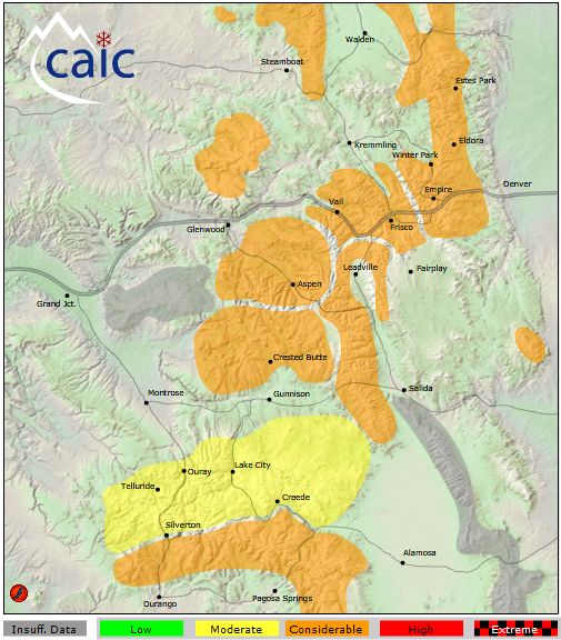
 Colorado Avalanche Information Center.  This was highlighted yesterday when a 27 year old man was killed just outside of Vail in an area known as the East Vail Chutes.  This is the second avalanche death of the season, the first being on December 2nd in Larimer County.  In the most recent case, these skiers had done everything right including having avalanche beacons but that was not enough. 

Avalanche Danger - 01/05/08

Everyone who intends to ski or hike in the high country, particularly outside of established areas, needs to be aware of the danger avalanches pose.  Recent weather has made the conditions ripe for these events.  The Forest Service National Avalanche Center points out that nearly all avalanches that involve people are triggered by the victims themselves or a member of their party.  The good news about that is that means that education can help to reduce the number of accidents we see each year.  To learn more, please see: