All posts by Thornton Weather

ThorntonWeather.com is your local source for live Thornton, Colorado weather conditions and news!

March 15 to March 21: This week in Denver weather history

This Week in Denver Weather History

This week is Denver and Thornton weather history is notable for many reasons.  2003 stands out as an extremely eventful year this week in weather history.  From March 17th to the 19th of that year, Denver was hit by one of its largest snowstorms in history.  Also, we see our first mention of a tornado for the year, also in 2003, on March 17th.  The twister hit near Strasburg but was short-lived and caused no damage.  These events serve as a reminder that winter is not over and severe weather can strike at any time.

From the National Weather Service:

9-19

In 1906…an extended cold and blustery period occurred with light snow totaling 14.4 inches over 11 consecutive days. The greatest amount of snow on a single day was 4.0 inches on the 15th. Only a trace of snow fell on the 12th and 17th. High temperatures were below freezing for the entire period. The coldest were 14 degrees on the 16th and 18 degrees on the 17th. Both readings were record low maximums for the dates. Low temperatures were mostly in the single digits. The coldest were 2 degrees below zero on the 16th and 5 degrees below zero on the 19th. Northeast winds were sustained to 22 mph on the 9th. North winds were sustained to 36 mph on the 10th…32 mph on the 13th…and 22 mph on the 15th.

12-16

In 1880…a protracted cold spell resulted in 8 temperature records being set. Record low temperatures for the date were set when the temperature dipped to 10 degrees below zero on the 13th and 14th…8 degrees below zero on the 12th and 15th…and 4 degrees below zero on the 16th. Daily record low maximum temperatures were set with 11 degrees on the 12th…12 degrees on the 13th…and 19 degrees on the 15th.

13-15

In 1906…snowfall totaled 8.0 inches over downtown Denver.

14-16

In 1908…a warm spell resulted in daily record high minimum temperatures on 3 consecutive days: 54 degrees on the 14th…52 degrees on the 15th…and 56 degrees on the 16th… Also the all-time record high minimum for the month of March. High temperatures ranged from 65 degrees on the 14th to 72 degrees on the 16th.

In 1983…a heavy wet snowstorm buried metro Denver with the foothills receiving the most. Conifer recorded 34 inches of snow with 4 feet measured at Coal Creek Canyon in the foothills northwest of Denver. The storm left 6 to 10 inches of snow across metro Denver. Boulder received 12 to 18 inches. Flight operations at Stapleton International Airport were limited to one runway for a time. Some roads and schools were closed…and power outages occurred when wet snow downed lines. Snowfall on the 15th and 16th totaled 7.2 inches at Stapleton International Airport where north winds gusted to 30 mph. Maximum snow depth on the ground was only 6 inches due to melting.

15

In 1902…northwest winds were sustained to 54 mph with gusts as high as 60 mph.

In 1920…southwest winds were sustained to 40 mph with gusts to 48 mph. The strong but cold downslope winds warmed the high temperature to only 35 degrees.

In 1935…strong winds howled across Boulder. At Valmont a wind gust to 60 mph was recorded. No damage was reported.

In 2006…strong winds ranging from 60 to 75 mph were reported in and near the foothills of Boulder County. In Longmont… Two trees toppled by the strong winds damaged a car. Winds gusted to 75 mph at the National Center for Atmospheric Research Mesa Laboratory in Boulder. West winds gusted to 52 mph at Denver International Airport.

15-16

In 2000…heavy upslope snowfall occurred in and near the Front Range foothills and over the palmer divide to the south of metro Denver. Snowfall totals from the storm included: 17 inches at Idaho Springs; 16 inches at Aspen Springs; 12 inches in Boulder; 11 inches at Bailey… Chief Hosa…Coal Creek Canyon…Eldorado Springs…Evergreen… And near Morrison; 10 inches at Intercanyon…Ken Caryl Ranch…and near Nederland; 9 inches near Sedalia and in Wheat Ridge; and 8 inches in Arvada. Snowfall totaled 5.4 inches at the site of the former Stapleton International Airport. Northeast winds gusted to 28 mph at Denver International Airport on the 15th.

16

In 1902…north winds were sustained to 40 mph with gusts to 48 mph.

In 1908…the low temperature dipped to only 56 degrees…the record high minimum for the month.

In 1963…high winds struck metro Denver causing heavy damage. Winds gusted at 90 to 100 mph in Boulder. Wind gusts to 98 mph were recorded at Jefferson County Airport in Broomfield where hangars and several light planes were severely damaged. Wind gusts to 87 mph were recorded southwest of Littleton. A west wind gust to 55 mph was recorded at Stapleton Airport. Trees were uprooted…signs blown down…and utility lines disrupted. Damage totaled nearly 5 thousand dollars in Boulder alone.

In 1987…a storm dropped 3 to 6 inches of snow across metro Denver with higher amounts in the foothills. Most of the snow on the plains melted as it fell. Only 1.9 inches of snow fell at Stapleton International Airport where southeast winds gusted to 30 mph.

In 2015…the temperature at Denver International Airport reached 81 degrees. It broke the previous record of 75 degrees and also made it the earliest the 80 degree day on record. The previous 80 degree day record was the 18th.

17

In 1966…high winds caused extensive minor damage across metro Denver. A light plane was overturned at Stapleton International Airport where northwest wind gusts to 55 mph were recorded. Winds gusted to 56 mph at Table Mesa in Boulder

In 1989…strong winds raked metro Denver. West wind gusts to 49 mph were clocked at Stapleton International Airport.

In 2003…the first tornado of the season was sighted near Strasburg. The small landspout touched down briefly…but caused no damage.

17-18

In 1923…4.2 inches of snow fell over downtown Denver. Northwest winds were sustained to 45 mph with gusts to 49 on the 17th. Low temperature of zero degrees on the 18th was the lowest of the month that year.

In 1944…heavy snow fell across metro Denver. The storm started as rain on the 17th…but soon turned to snow. Snowfall amounts totaled 8.5 inches in downtown Denver and 11.0 inches at Stapleton Airport. The highest wind recorded during the storm was 23 mph on the 17th.

In 1961…a major winter storm dumped 10.7 inches of snow at Stapleton Airport. Most of the snow…9.7 inches…fell on the 18th. Winds were light.

In 1994…strong winds buffeted metro Denver. West winds gusted to 51 mph at Stapleton International Airport on the 17th. Other significant wind gusts included 85 mph atop Squaw Mountain south of Idaho Springs…and 82 mph at Rollinsville southwest of Boulder…both on the 18th.

In 1996…a second storm in less than 3 days dumped heavy snow in the mountains and foothills again…but snowfall amounts across metro Denver ranged from only 2 to 4 inches. The heavy snowfall resulted in several traffic accidents along I-25 and I-70…south and west of Denver respectively. The major accidents involved at least 30 cars and resulted in several minor injuries. The accidents closed both highways for a time. Snowfall totals included 13 inches at Evergreen and 10 inches at Conifer. Snowfall totaled only 0.7 inch at the site of the former Stapleton International Airport. At Denver International Airport… North winds gusted to 28 mph on the 17th and 39 mph on the 18th.

In 2016…a combination of enhanced banding associated with a strong upper level jet stream…and low level upslope following the passage of a cold front…produced heavy snowfall in northern mountains as well as in and near the foothills of Boulder County. Storm totals included: 19.5 inches near Ward…16 inches near Allenspark…13.5 inches near Eldorado Springs; 13 inches at the National Weather Service Office in Boulder and 5 miles east of Boulder; 12.5 inches at Winter Park Ski Resort…12 inches at Eldora Ski Area; 11 inches…7 miles south of Lyons and at Rollinsville; 10.5 inches at Aspen Springs… and 9.5 inches near Blackhawk. In Denver and the surrounding suburbs…storm totals included: 8.5 inches in Broomfield…Lafayette and 5 miles northeast of Westminster; 7 inches near Northglenn…6.5 inches in Thornton and northwest Denver; with 6 inches at Firestone. At Denver International Airport…an official measurement of 4.7 inches of snow was observed.

17-19

In 1933…rain changed to snow on the evening of the 17th and continued through mid-day of the 19th. Snowfall totaled 5.6 inches with 0.83 inch of precipitation in in the city. North winds were sustained to 38 mph with gusts to 46 mph on the 18th and to 30 mph with gusts to 43 mph on the 19th.

In 2003…one of the worst blizzards since historic records began in 1872 struck metro Denver with a vengeance. Heavy wet snow accumulating to around 3 feet in the city and to more than 7 feet in the foothills brought transportation to a near standstill. North winds sustained to 30 mph with gusts as high as 41 mph produced drifts to 6 feet in the city. The estimated cost of property damage alone…not including large commercial buildings…was 93 million dollars… Making it the costliest snowstorm ever. Mayor Wellington Webb of Denver said…”this is the storm of the century…a backbreaker…a record breaker…a roof breaker.” Two people died in Aurora from heart attacks after shoveling the heavy wet snow. The National Guard sent 40 soldiers and 20 heavy duty vehicles to rescue stranded travelers along I-70 east of gun club road. The heavy wet snow caused roofs of homes and businesses to collapse. The snow also downed trees… Branches…and power lines. Two people were injured when the roofs of their homes collapsed. In Denver alone…at least 258 structures were damaged. In Arvada…a roof collapse at west gate stables killed a horse. Up to 135 thousand people lost power during the storm…and it took several days for power to be restored in some areas. Denver International Airport was closed…stranding about 4000 travelers. The weight of the heavy snow caused a 40-foot gash in a portion of the tent roof…forcing the evacuation of that section of the main terminal building. Avalanches in the mountains and foothills closed many roads…including I-70…stranding hundreds of skiers and travelers. Along I-70…an avalanche released by the Colorado Department of Transportation…blocked the interstate in both directions for several hours. Several residences between Bakerville and Silver Plume were evacuated because of the high avalanche danger. At Eldora ski area…270 skiers were stranded when an avalanche closed the main access road. After the storm ended…a military helicopter had to ferry food to the resort until the road could be cleared. The heavy snow trapped thousands of residents in their foothills homes in Jefferson County for several days. Two homes burned to the ground when fire crews could not reach the residences. Some schools remained closed well into the following week. The storm officially dumped 31.8 inches of snow at the site of the former Stapleton International Airport…the most snowfall from a single storm since the all-time record snowfall of 37.5 inches on December 4-5…1913. The storm made March 2003 the snowiest March on record…the 4th snowiest month on record… And the 5th wettest March on record. The 22.9 inches of snow on the 18th into the 19th was the greatest 24 hour snowfall ever recorded in the city during the month of March. The storm was also a drought-buster…breaking 19 consecutive months of below normal precipitation in the city. Snowfall across metro Denver ranged from 2 feet to more than 3 feet. The highest amounts included: 40 inches in Aurora…38 inches in Centennial and 6 miles east of Parker…37 inches at Buckley AFB…35 inches in southwest Denver…34 inches in Louisville… 32 inches in Arvada…31 inches in Broomfield and Westminster… And 22.5 inches in Boulder. In the foothills…snowfall ranged from 3 feet to more than 7 feet. Some of the most impressive storm totals included: 87.5 inches atop Fritz Peak and in Rollinsville…83 inches at Cabin Creek…74 inches near Bergen Park…73 inches northwest of Evergreen…72 inches in Coal Creek Canyon…70 inches at Georgetown…63 inches near Jamestown…60 inches near Blackhawk…55 inches at Eldora Ski Area…54 inches 8 miles west of Sedalia…and 46.6 inches at Ken Caryl Ranch. The storm was the result of a very moist…intense slow moving pacific system which tracked across the four corners and into southeastern Colorado…which allowed deep easterly upslope flow to form along the Front Range.

18

In 1883…0.3 inch of snow fell in downtown Denver. This was the only measurable snowfall of the month.

In 1903…rain changed to sleet and then to snow…which became heavy. Post-frontal snowfall totaled 7.0 inches over the city. North winds were sustained to 51 mph with gusts as high as 60 mph.

In 1905…northwest winds were sustained to 42 mph.

In 1914…northeast winds were sustained to 46 mph with gusts to 56 mph behind a strong cold front. Snowfall was 3.4 inches over the city…but most of the snow melted as it fell. The estimated amount of melted snow was 8.1 inches.

In 1920…a terrific windstorm occurred along the eastern foothills. Two deaths were attributed to the storm and some damage occurred. Both Denver and Boulder were affected by the strong winds. West winds were sustained to 51 mph with gusts as high as 66 mph in downtown Denver. The strong winds did considerable damage to property… Wires…plate glass windows…and indirectly loss by fire. The wind caused the death of one young girl by toppling the side of a brick building on her as she was standing on a corner waiting for a car. The wind was also responsible for several severe auto accidents due to blowing debris into the streets and blowing dust and dirt into the eyes of drivers.

In 1954…west winds at sustained speeds of 40 mph and gusts as high as 56 mph produced some blowing dust at Stapleton Airport.

In 1979…heavy snow totaled 4 to 12 inches along the Front Range from Denver north. I-25 was closed for a brief time between Denver and Cheyenne. New snowfall totaled 4.3 inches at Stapleton International Airport where north winds gusted to 29 mph.

In 1998…a major winter storm dumped heavy snow over areas west from I-25 to the continental divide as strong upslope conditions developed. Two to 3 1/2 feet of snow fell in the foothills with 1 to 2 feet reported in west metro Denver. Snowfall totals included: 38 inches at Silver Spruce Ranch…2 miles south of Ward; 35 inches at Aspen Springs; 33 inches near Blackhawk; 30 inches at Eldora; 29 inches in Coal Creek Canyon; 27 inches at Conifer… Chief Hosa…and Nederland; 25 inches at Rollinsville and Gross Reservoir; 21 inches at Evergreen; and 15 to 19 inches at Broomfield…Lakewood…and Table Mesa in Boulder. Elsewhere across metro Denver…snowfall ranged from 8 to 14 inches. Snowfall totaled only 7.9 inches at the site of the former Stapleton International Airport. East winds gusted to 31 mph at Denver International Airport.

Continue reading March 15 to March 21: This week in Denver weather history

March 8 to March 14: This week in Denver weather history

This Week in Denver Weather History

Our look back at Denver weather history for the week reminds us that although the calendar says it is March, it is still very much winter.  Numerous mentions of snow, blizzards and related winter conditions are quite prevelant and we are reminded that March after all is our snowiest month.

From the National Weather Service:

6-8

In 1932…snowfall totaled 6.3 inches in downtown Denver. Most of the snow…5.2 inches…fell on the 8th. Northeast winds gusted to 20 mph on the 6th.

7-8

In 1878…snow from the evening of the 7th until noon of the 8th totaled only 5 inches in downtown Denver. Apparent heavier snow over the plains along with strong winds drifted the snow into high drifts…which delayed trains for several days and caused a great loss of livestock. Melting of the snow caused a rise in Cherry Creek…which resulted in much damage. Precipitation from the storm totaled only 0.50 inch in Denver.

In 2000…high winds developed in and near the Front Range foothills…as well as parts of the northeast Colorado plains as another pacific storm system moved across the area. Several trees and power lines were downed near Blackhawk…Boulder…and in Coal Creek Canyon. About 30 homes in the Pinebrook Hills subdivision in Boulder were evacuated when downed power lines sparked a grassfire. The winds eventually shifted the fire onto itself…thus allowing firefighters to contain the two acre blaze. Several roofs were blown off barns…sheds… And garages. Two semi-trailers were blown over…one along c-470 between Golden and Morrison and another north of Denver on I-25. Wind gusts reached 101 mph on Rocky Flats…100 mph at the nearby National Wind Technology Center…90 mph at Blackhawk and atop Blue Mountain…92 mph in south Boulder…73 mph in Coal Creek Canyon…72 mph in Golden…and 70 mph at Louisville. Northwest winds gusted to 45 mph on the 7th and to 49 mph on the 8th at Denver International Airport.

8

In 1878…winds started to increase at 4:00 am and blew steadily at sustained speeds of 36 to 40 mph with a maximum sustained speed of 60 mph around 11:00 am. Snowfall of 5.0 inches occurred in the city…but much more snow fell on the plains…which blockaded trains bound for the city for several days.

In 1898…northwest winds sustained to 53 mph with gusts to 60 mph warmed the temperature to a high of 67 degrees.

In 1908…light snowfall of 0.8 inch produced only 0.01 inch of precipitation. This along with the 0.10 inch of precipitation on the 21st resulted in the driest March on record with a total of 0.11 inch of precipitation.

In 1986…temperatures climbed from a record high minimum of 45 degrees to a record maximum of 72 degrees for the day.

In 2005…a vigorous cold front moved a wall of blowing dust across metro Denver during the mid-morning. At Denver International Airport…north winds sustained to 48 mph with gusts as high as 55 mph…along with very light rain which changed to snow…briefly reduced the surface visibility to 1 mile. A thunderstorm formed over Arvada. With the passage of the cold front…the temperature plunged 11 degrees in just 16 minutes at Denver International Airport where precipitation was only 0.01 inch along with 0.1 inch of snow.

8-9

In 1992…a major blizzard struck metro Denver. The storm was preceded by thunderstorms with small hail during the afternoon of the 8th. By evening…with the passage of a strong arctic cold front…snow began falling. Strong north to northeast winds at 30 to 40 mph with gusts to 52 mph produced near zero visibilities in blizzard conditions across metro Denver. By the morning of the 9th…snowfall amounts up to a foot and a half were reported with drifts of 2 to 4 feet. Many roads were closed including I-70 east of Denver and I-25 both north and south of Denver. Many homes and stores were temporarily without power. Snowfall amounts included: 18 inches at Conifer…13 inches in Boulder and Denver…12 inches at Brighton and Morrison…and 10 inches at Aurora. Snowfall totaled 12.4 inches at Stapleton International Airport where north winds gusting as high as 52 mph reduced the visibility to zero at times in heavy snow and blowing snow.

In 2002…high winds occurred in the foothills west of Denver. Winds gusted to 95 mph near Fritz Peak and to 73 mph near Nederland.

8-10

In 1989…unusually warm weather set four daily temperature records in Denver. The high temperature of 74 degrees on the 8th exceeded the record. Records were equaled on the 9th with a high of 77 degrees and the 10th with a high of 79 degrees. The low temperature of 42 degrees on the 10th set a new record high minimum for the date.

9

In 1918…northwest winds sustained to 44 mph with gusts as high as 52 mph occurred during the early morning hours.

In 1960…west-northwest winds gusted to 51 mph at Stapleton Airport.

In 1980…high winds were recorded in the foothills with a wind gust to 84 mph at Wondervu. Northwest winds gusted to 38 mph at Stapleton International Airport.

In 1982…strong Chinook winds buffeted the foothills in Boulder. Wind gusts of 60 to 90 mph toppled a microwave dish antenna and blew the shell off a camper. West winds gusted to 47 mph at Stapleton International Airport.

In 1986…high winds in the foothills with gusts of 60 to 70 mph were reported at Golden Gate Canyon and in Boulder. Northwest winds gusted to 35 mph at Stapleton International Airport.

9-10

In 1904…strong Chinook winds raked the city for 2 days. On the 9th…west winds sustained to 53 mph with gusts to 62 mph warmed the temperature to a high of 55 degrees. On the 10th…west winds were sustained to 48 mph with gusts to 54 mph. The high temperature was 58 degrees.

In 2013…a storm system brought heavy snow to areas in and near the Front Range mountains and foothills where storm totals included: 13 inches at Berthoud Pass SNOTEL…12 inches at Arapahoe Ridge; 11 inches…5 miles southwest of Golden; 10.5 inches near Kittridge; 10 inches at Lake Eldora and Pine Junction; 9.5 inches near Conifer…9 inches…near Bailey and 9 miles east-northeast of Nederland…Joe Wright and Strontia Springs. Along the urban corridor…some storm totals included: 8.5 inches at Highlands Ranch and near Morrison; 8 inches in Arvada; 7 inches…5 miles northeast of Westminster; 6.5 inches at Centennial…lone tree and Wheat Ridge; 6 inches in west Denver…Hygiene…Lyons and Thornton…5.5 inches in Broomfield; with 5 inches in Aurora and the former Stapleton International Airport. Across the Palmer Divide and northeast plains of Colorado…storm totals ranged anywhere from 2 to 10 inches. The combination of snow and strong wind produced blizzard conditions and forced the closure of Interstate 70 east of Denver. Sustained winds of 25 to 35 mph with gusts to 45 mph produced near zero visibilities at times and snowpacked roads. Snowdrifts from 2 to 4 feet deep were reported. As a result…many of the roadways became impassable. Officially…Denver international recorded 5.4 inches of snowfall on the 9th. In addition…a peak wind gust to 38 mph was observed from the north.

9-11

In 1927…rain changed to heavy snow behind a cold front and totaled 7.7 inches over downtown Denver. North winds were sustained to 37 mph with an extreme velocity to 38 mph on the 11th.

In 1955…a strong windstorm raked the eastern foothills. A wind gust to 95 mph was recorded at Rocky Flats with a gust to 60 mph measured at Valmont. Damage in Boulder totaled 10 thousand dollars. Minor injuries also occurred. The strong winds were associated with a vigorous cold front that produced northwest winds at 40 mph with gusts as high as 52 mph at Stapleton Airport where the visibility was briefly reduced to 3/4 mile in blowing dust on the 10th.

In 1968…5.5 inches of snow fell at Stapleton International Airport where northeast winds gusted to 24 mph on the 10th.

9-19

In 1906…an extended cold and blustery period occurred with light snow totaling 14.4 inches over 11 consecutive days. The greatest amount of snow on a single day was 4.0 inches on the 15th. Only a trace of snow fell on the 12th and 17th. High temperatures were below freezing for the entire period. The coldest were 14 degrees on the 16th and 18 degrees on the 17th. Both readings were record low maximums for the dates. Low temperatures were mostly in the single digits. The coldest were 2 degrees below zero on the 16th and 5 degrees below zero on the 19th. Northeast winds were sustained to 22 mph on the 9th. North winds were sustained to 36 mph on the 10th…32 mph on the 13th…and 22 mph on the 15th.

10

In 1893…northwest winds were sustained to 48 mph with gusts to 60 mph in the city.

In 1948…the high temperature warmed to only 6 degrees… The all-time record low maximum for the month of March. The same reading also occurred on March 6…1920.

In 1970…5.0 inches of snow fell at Stapleton International Airport where north winds gusted to 21 mph.

10-11

In 1886…snowfall of 3.5 inches was measured in downtown Denver. Apparent post-frontal north winds were sustained to 43 mph on the 11th.

In 1977…a major blizzard struck metro Denver. Snowfall totaled 8.0 inches at Stapleton International Airport where north winds at speeds of 30 to 40 mph with gusts to 60 mph frequently reduced visibilities in blowing snow to 1/4 mile or less. Most of the snow…7.7 inches…fell on the 10th. The snow ended by daybreak on the 11th…but strong north winds persisted through the day.

In 1988…a late winter storm produced heavy snow and wind… Mainly north of Denver. Wind gusts reached 62 mph at Keenesburg and produced a lot of blowing snow…closing schools in southwest weld County. The storm closed I-70 east of Denver. Only 1.1 inch of snow fell at Stapleton International Airport…but north winds gusted to 39 mph.

10-12

In 1924…snowfall was heavy and totaled 9.9 inches over downtown Denver. North winds were sustained to 18 mph on the 11th.

In 2001…heavy snow fell over northeast Colorado and metro Denver when a combination of upslope winds and convective snow bands formed over the area. Storm totals included: 11 inches at the Eldora Ski Resort; 10 inches at Genesee; 8 inches at Elizabeth…atop Lookout Mountain…near Sedalia… And at Strasburg; 7 inches near Castle Rock and Evergreen; and 6 inches in Aurora…atop Crow Hill…and in Parker. Elsewhere across metro Denver…snowfall ranged from 2 to 5 inches with 3.9 inches at the site of the former Stapleton International Airport. North winds gusted to 28 mph at Denver International Airport on the 10th.

Continue reading March 8 to March 14: This week in Denver weather history

National Weather Service announces storm spotter training dates for 2020

On June 3, 1981 a tornado struck Thornton in what is the worst twister to have struck the Denver metro area. Are you ready should disaster strike again? Image courtesy the City of Thornton archives.

Severe weather is a fact of life in Colorado – from blizzards to tornadoes we can and do see it all.  Each year the weather is responsible for claiming lives in our state and across the nation and the threat is very real.  Storm spotter training allows you to learn how to protect yourself and your family while providing a public service.

Education is key to knowing how to protect you and your family.  Whether you want to be an official storm spotter or maybe just want to learn more about severe weather, storm spotter training can provide you an incredible opportunity to learn.

The National Weather Service Denver / Boulder office has announced a series of Skywarn storm spotter training dates for Colorado for the 2020 season.

The storm spotter program is a nationwide program with more than 280,000 trained spotters.  These volunteers report weather hazards to their local National Weather Service office providing vital information when severe strikes.  Data from spotters include severe wind, rain, snow measurements, thunderstorms and hail and of course tornadoes.

Storm spotters are part of the ranks of citizens who form the Nation’s first line of defense against severe weather. There can be no finer reward than to know that their efforts have given communities the precious gift of time–seconds and minutes that can help save lives.

By completing one of these training classes you can become an official storm spotter.  When severe weather strikes, you can report it by calling a special toll free number or submit your report via the National Weather Service’s website.

These are great sessions for anyone wanting to learn more about the severe weather we experience in Colorado, whether you want to be an official spotter or not.  All training is free.  Topics include:

  • Basics of thunderstorm development
  • Fundamentals of storm structure
  • Identifying potential severe weather features
  • Information to report
  • How to report information
  • Basic severe weather safety

To learn more about the program, see here: http://www.crh.noaa.gov/bou/awebphp/spotter.php

Below are the dates, times and locations announced thus far.  The embedded calendar should automatically update with new dates and changes but be sure to check the National Weather Service site for the latest.


–>

‘Springing forward’ as Daylight Saving Time to begin Sunday, March 8th

The United States returns to Daylight Saving Time at 2:00am Sunday, March 8, 2020.

The biannual ritual of changing our clocks to adjust for Daylight Saving Time occurs this Saturday night providing yet another signal of the changing of seasons.  The United States will ‘spring forward’ one hour at 2:00am Sunday morning as we begin Daylight Saving Time.

The ritual of changing our clocks twice a year can be met with some resistance as some people struggle to adjust their body’s internal clock.  The start of Daylight Saving Time can be particularly problematic given the one hour less sleep people receive on the night of the change.

However, longer days as we head into the milder months are a very real benefit and for many worth the inconvenience of a lost hour of sleep.  The time change definitely has big effects on how much daylight we enjoy during our normal waking hours.

On Saturday, prior to the change, sunset will occur at 5:59pm but on Sunday the sun won’t disappear over the horizon until 7:00pm.  This affords folks more time in the evening to get started on those spring-time chores and allows us to get outside and enjoy the warming weather.

The March Equinox is also on the horizon.  Spring officially begins at 9:49pm on Thursday, March 19.

This year Daylight Savings Time will come to an end on November 1.

Some of the recent history of Daylight Savings Time (from Wikipedia):

Daylight saving time in the United States was first observed in 1918. Most areas of the United States currently observe daylight saving time, with the exceptions being the states of Arizona and Hawaii along with the territories of Puerto Rico, American Samoa, Guam, and the Northern Mariana Islands.

From 1987 to 2006, daylight saving time in the United States began on the first Sunday of April and ended on the last Sunday of October. The time was adjusted at 2:00 AM (0200) local time (as it still is done now).

Since 2007, daylight saving time starts on the second Sunday of March and ends on the first Sunday of November, with all time changes taking place at 2:00 AM (0200) local time.

Daylight Savings Time Schedule

Year DST Begins 2 a.m.
(Second Sunday in March)
DST Ends 2 a.m.
(First Sunday in November)
2020 8 March 2020 1 November 2020
2021 14 March 2021 7 November 2021
2022 13 March 2022 6 November 2022
2023 12 March 2023 5 November 2023
2024 10 March 2024 3 November 2024
2025 9 March 2025 2 November 2025
2026 8 March 2026 1 November 2026

February 2020 weather recap: Colder than normal temps, above normal snowfall

Certainly when you look back on February 2020, you probably will remember it as being cold and snowy. That indeed is true, as the numbers show, however that really only pertained to the first half of the month. The latter part was far more on par with what we expect to see.

The month did start out quite warm as we saw temperature readings well above normal on the first and second. The third, however, brought about significant changes and an end to the warmth that had carried over from January.

Several storm systems moved through over the next 10 days, bringing significantly colder temperatures and regular doses of snow. Indeed, 8 of the first 12 days of the month brought measurable snowfall. Into the third week of the month it appeared we were on pace for one of the coldest Februarys on record.

Things changed again on the 21st and five of the last nine days of the month brought warmer than normal temperatures. This was enough to drive up our average temperature which, while it did come in well below normal, was not in record-setting territory.

Thornton’s average temperature for the month came in at 29.9 degrees. This was a good ways below Denver’s long term average for February of 32.5 degrees. Out at Denver International Airport where the Mile High City’s official measurements are taken, it actually was colder with an average of 28.1 degrees.

Our temperatures ranged from a high of 73.7 degrees on the 2nd down to a low of -2.2 degrees on the morning of the 5th. Out at DIA, they saw their warmest and coldest temperatures of 74 degrees and -5 degrees on the same dates.

Precipitation came in well above the Denver average for the month of 0.37 inches. Thornton recorded 1.09 inches while Denver measured 0.88 inches.

Snow was of course notable for the first half of the month and drove the monthly totals. On average, Denver receives 5.7 inches in February.  Thornton far surpassed that with 22.1 inches and Denver did as well with 16.5 inches of the white stuff.

Click here to view Thornton’s February 2020 climate report.

Thornton, Colorado's February 2020 Temperature Summary. (ThorntonWeather.com)
Thornton, Colorado’s February 2020 Temperature Summary. (ThorntonWeather.com)
Thornton, Colorado's February 2020 Precipitation Summary. (ThorntonWeather.com)
Thornton, Colorado’s February 2020 Precipitation Summary. (ThorntonWeather.com)
CLIMATE REPORT
NATIONAL WEATHER SERVICE DENVER/BOULDER CO
717 AM MST SUN MAR 1 2020

...................................

...THE DENVER CO CLIMATE SUMMARY FOR THE MONTH OF FEBRUARY 2020...

CLIMATE NORMAL PERIOD 1981 TO 2010
CLIMATE RECORD PERIOD 1872 TO 2020

WEATHER         OBSERVED          NORMAL  DEPART  LAST YEAR`S
                 VALUE   DATE(S)  VALUE   FROM    VALUE  DATE(S)
                                          NORMAL
................................................................
TEMPERATURE (F)
RECORD
 HIGH              80   02/10/2017
 LOW              -25   02/01/1951
                        02/08/1936
HIGHEST            74   02/02        66       8       65  02/03
LOWEST             -5   02/05                -4      -11  02/07
                        02/04
AVG. MAXIMUM     39.9              46.2    -6.3     40.8
AVG. MINIMUM     16.3              18.9    -2.6     15.3
MEAN             28.1              32.5    -4.4     28.0
DAYS MAX >= 90      0               0.0     0.0        0
DAYS MAX <= 32     10               3.9     6.1        8
DAYS MIN <= 32     28              26.9     1.1       26
DAYS MIN <= 0 2 1.3 0.7 3 PRECIPITATION (INCHES) RECORD MAXIMUM 2.01 1934 MINIMUM 0.01 1970 TOTALS 0.88 0.37 0.51 0.72 DAILY AVG. 0.03 0.01 0.02 0.03 DAYS >= .01         9               5.3     3.7        6
DAYS >= .10         4               0.7     3.3        3
DAYS >= .50         0               0.0     0.0        0
DAYS >= 1.00        0               0.0     0.0        0

GREATEST
 24 HR. TOTAL    0.19     02/12

SNOWFALL (INCHES)
TOTALS           16.5               5.7             13.4  2019
RECORD           22.4      2015

DEGREE_DAYS
HEATING TOTAL    1063               908     155     1029
 SINCE 7/1       4499              4468      31     4417
COOLING TOTAL       0                 0       0        0
 SINCE 1/1          0                 0       0        0

FREEZE DATES
RECORD
 EARLIEST     09/08/1962
 LATEST       06/08/2007
EARLIEST                        10/07
LATEST                          05/05
.................................................................

WIND (MPH)
AVERAGE WIND SPEED              10.3
RESULTANT WIND SPEED/DIRECTION   2/212
HIGHEST WIND SPEED/DIRECTION    40/350    DATE  02/25
HIGHEST GUST SPEED/DIRECTION    54/350    DATE  02/25

SKY COVER
POSSIBLE SUNSHINE (PERCENT)   MM
AVERAGE SKY COVER           0.60
NUMBER OF DAYS FAIR            8
NUMBER OF DAYS PC             13
NUMBER OF DAYS CLOUDY          8

AVERAGE RH (PERCENT)     64

-  INDICATES NEGATIVE NUMBERS.
R  INDICATES RECORD WAS SET OR TIED.
MM INDICATES DATA IS MISSING.
T  INDICATES TRACE AMOUNT.

Thornton’s March 2020 weather preview: Warmer temps arrive, significant snows possible

The month of March in Denver is usually one that is welcomed heartily by residents. We begin to shake off the cold of winter with warmer temperatures and calmer conditions. That does not mean we are done with snow and cold by any means.

March usually offers healthy snowfall giving us an opportunity to add to our seasonal totals.  While there is good snow potential in March, the month also typically brings much warmer temperatures.

March is historically Denver’s snowiest month and brings about 20% of our annual snowfall.  Heavy, wet spring snow storms can oftentimes bring the entire month’s snowfall total in one monstrous snow.

We also start the transition to spring and severe weather season and the month typically brings our first thunderstorms of the year.  Temperatures climb throughout the month and by the end our average daytime highs are near 60 degrees.

For a complete look at what lies ahead in March 2020, click here.

March 1 to March 7: This week in Denver weather history

This Week in Denver Weather History

Looking at this week in Denver weather history, it is easy to see why March is known as Denver’s snowiest month. There are numerous instances of major winter storms dumping snow on the city that was measured not in inches – but feet!

From the National Weather Service:

28-1

In 1875…6 inches of snow fell from 3:15 pm on the 28th to 1:00 am on the 1st. Precipitation for the two days was 0.50 inch.

29-1

In 1896…snowfall totaled 5.5 inches in the city. Northeast winds gusted to 24 mph.

In 1948…snowfall totaled 5.9 inches in downtown Denver. North winds were sustained to 15 mph.

1

In 1904…west winds were sustained to 42 mph with gusts as high as 58 mph. The Chinook winds warmed the temperature to a high of 67 degrees.

In 1906…snowfall was heavy and totaled 7.5 inches over downtown Denver. Northeast winds were sustained to 37 mph.

In 1940…snowfall was heavy and totaled 7.7 inches in downtown Denver.

In 1943…6.0 inches of snow fell over downtown Denver. North winds were sustained to 19 mph.

In 1956…west-northwest wind gusts to 52 mph were recorded at Stapleton Airport.

In 1961…a wind gust to 65 mph was recorded at the Colorado building in downtown Boulder. The high winds caused some minor damage. Northwest winds gusted to 43 mph at Stapleton International Airport.

In 1974…a wind gust to 77 mph was recorded in Boulder. Southwest winds gusted to 37 mph at Stapleton International Airport.

In 2002…upslope conditions caused heavy snow to develop in and near the eastern foothills. Snow totals included 14 inches at Eldorado Springs and near Genesee; 13 inches atop Lookout Mountain; 12 inches in Coal Creek Canyon; 10 inches in Nederland and just east of Boulder; 9 inches in Boulder and Morrison; and 8 inches at Broomfield…Erie… Golden…Louisville…and Littleton. Snowfall totaled 6.5 inches at the site of the former Stapleton International Airport. Northeast winds gusted to 31 mph at Denver International Airport.

In 2014…a localized band of heavy snow over downtown Denver produced around one inch in less than 30 minutes and contributed to a chain of accidents in the northbound lanes of Interstate 25…between Logan Street and University Blvd. The combination of excessive speed and very poor driving conditions led the chain reaction; it involved 104 vehicles and resulted in one death along with 30 injuries. The interstate was closed for approximately 5 hours. At Denver International Airport…1 inch of snow was observed.

1-2

In 1969…heavy snowfall totaled 7.0 inches at Stapleton International Airport where north-northwest winds gusted to 18 mph.

In 1988…3 to 6 inches of snow fell over metro Denver. Snowfall totaled 3.2 inches at Stapleton International Airport where north winds gusted to 32 mph.

In 2003…localized heavy snow developed in the foothills of Jefferson County. Storm totals included: 12.5 inches near Conifer…11 inches in the foothills southwest of Boulder…and 10 inches near Genesee. Only 0.9 inch of snow fell at the site of the former Stapleton International Airport.

2

In 1904…west winds sustained to 52 mph with gusts to 60 mph warmed the temperature to a high of 68 degrees. Snowfall was 0.4 inch in the evening.

In 2008…a storm system brought heavy snow to portions of the Front Range foothills; as well as localized blizzard conditions to areas along the palmer divide. In the foothills of Jefferson and Park counties storm totals included: 16 inches at Genesee…14 inches…4 miles south of Evergreen; 13 inches…3 miles southeast of Pinecliffe; 12 inches…5 miles west-southwest of Conifer; 10 inches at Evergreen and 5 miles west of Littleton. Along the Palmer Divide…south and southeast of Denver… The combination of gusty northerly winds and snow caused localized blizzards. Storm totals included: 7 inches… 2 miles east of Castle Rock; 6 inches…4 miles east of Parker and 2 miles northwest of Elizabeth; and 5 inches near Castle Pines. The wind…gusting to 35 mph…stirred up snow drifts from 1 to 3 feet in depth. Northeast winds gusted up to 49 mph at Denver International Airport; and 2.0 inches of snow was observed at the former Stapleton International Airport.

2-3

In 1901…strong northwest winds raked the city for 2 days. On the 2nd…winds were sustained to 55 mph with gusts to 62 mph. The Chinook winds warmed the temperature to a high of 72 degrees…a record maximum for the date. On the 3rd…winds were sustained to 61 mph with gusts as high as 65 mph. The high temperature was 59 degrees.

In 1964…heavy snowfall of 6.3 inches was measured at Stapleton International Airport. East winds gusted to only 20 mph behind a cold front.

In 1978…5.0 inches of snowfall were measured at Stapleton International Airport where northeast winds gusted to 24 mph on the 2nd. The passage of a cold Canadian front kept temperatures only in the teens and 20’s on the 2nd after a high temperature of 33 degrees shortly after midnight. The temperature…after a morning low of 3 degrees below zero…climbed to only 14 degrees on the 3rd…setting a record low maximum for the date.

2-4

In 1963…heavy wet snow was accompanied by strong gusty winds across metro Denver. Snowfall totaled 11.6 inches at Stapleton Airport where north winds gusting to 44 mph caused much blowing and drifting snow. Hazardous driving conditions resulted in many traffic accidents.

In 1976…snowfall totaled 8.0 inches at Stapleton International Airport where…on the 4th…northeast winds gusted to 31 mph reducing the visibility to as low as 1/4 mile. Maximum snow depth on the ground was 7 inches. Nine inches of snow were measured in Boulder.

3

In 1875…six inches of snow fell in Georgetown.

In 1895…northwest bora winds were sustained to 45 mph with gusts to 58 mph in the city.

In 1966…cold northwest wind gusts of 50 to 90 mph occurred across metro Denver. Both cars and trucks were blown off an icy highway just east of Denver where some highways were closed by either blowing dust or blowing snow. A northwest wind gust to 43 mph was recorded at Stapleton International Airport. The strong winds caused limited minor damage.

In 1972…winds gusted to 55 mph in Boulder causing no reported damage. West winds gusted to 49 mph at Stapleton International Airport.

In 1985…snow struck metro Denver. Heaviest hit was Boulder where 6 to 8 inches were measured. Icy roads caused the closure of I-25 north and south of Denver due to traffic accidents. The snow also caused long delays at Stapleton International Airport where snowfall totaled only 2.6 inches.

In 1997…west winds gusted to 52 mph at Denver International Airport.

3-4

In 1932…a dust storm occurred on the 3rd during the late afternoon. North winds gusting as high as 38 mph behind a cold front kicked up much blowing dust. Light snow developed during the evening and continued through the early morning of the 4th. Snowfall totaled 2.7 inches.

In 1934…strong winds raked Boulder. A wind gust to 62 mph was recorded at Valmont just east of Boulder. The strong winds caused hundreds of dollars of damage in Boulder.

In 1981…the most vigorous snow storm of the season struck the state…closing many schools and most highways connecting Denver…Colorado Springs…and Limon. North winds gusting to 43 mph whipped nearly 10 inches of snow in Denver into 3-foot drifts and snarled traffic on the morning of the 4th. Snowfall totaled 9.8 inches at Stapleton International Airport.

In 1989…a storm dumped 2 to 6 inches of snow across metro Denver. The snow caused 2-hour air traffic delays at Stapleton International Airport where 3.0 inches of snow fell and north winds gusted to 23 mph on the 3rd. There were many traffic accidents across metro Denver. I-70 was closed east of Denver for a time on the 3rd.

In 1991…high winds raked the eastern foothills. Wind gusts of 60 to 90 mph were common with 119 mph recorded at Wondervu southwest of Boulder…106 mph on Shanahan ridge and 92 mph at Table Mesa…both in southwest Boulder. Several trees were uprooted and traffic signs and lights blown over. Flying debris caused damage to homes… Buildings…and cars. In Boulder…a stop sign was blown onto a car. There were no reports of injuries. Southwest winds gusting as high as 48 mph briefly reduced the prevailing visibility to as low as 1/16th mile in blowing dust at Stapleton International Airport on the 4th.

3-5

In 1961…snowfall totaled 8.3 inches at Stapleton Airport over the 3-day period with most of the snow…4.4 inches… Falling on the 3rd. Winds were generally light gusting to only 23 mph.

Continue reading March 1 to March 7: This week in Denver weather history

February 2020 top shots: Monthly photo slideshow

An amazing sunset starts off February in style. (Renee Franz)

February signifies the start of the climb toward warmer temperatures for the year.  Cold and snow though do intrude but, coupled with milder conditions, there are lots of photo opportunities as can be seen in our monthly slideshow.

The month is one of our least snowiest of the year but it isn’t unusual to see the landscape blanketed in white.  Warming temperatures through the month can bring the onset of spring fever and gives residents the opportunity to enjoy some prolonged time outdoors on the mild days.

Cold or mild, snowy or dry, our scenery is almost always gorgeous – and photo worthy.

  • Slideshow updated February 28, 2020
  • To learn more about how to send your photo to us for inclusion in the slideshow, see below the slideshow.

Showcasing images captured by ThorntonWeather.com readers as well as some of our own, our monthly slideshow covers the entire gamut of weather-related imagery.

Sunsets, sunrises, wildlife and of course every type of weather condition are vividly depicted in images captured from yours and our cameras.

[flickr_set id=”72157712939478292″]

What is missing in the slideshow above?  Your photo!

Our monthly photo slideshow is going to feature images that we have taken but more importantly images that you have captured.  The photos can be of anything even remotely weather-related.

Landscapes, current conditions, wildlife, pets, kids.  Whimsical, newsy, artsy.  Taken at the zoo, some other area attraction, a local park, a national park or your backyard.  You name it, we want to see and share it!

Images can be taken in Thornton, Denver or anywhere across the extraordinary Centennial State.  We’ll even take some from out of state if we can tie it to Colorado somehow.

We’ll keep the criteria very open to interpretation with just about any image eligible to be shown in our slideshows.

What do you win for having your image in our slideshow?  We are just a ‘mom and pop’ outfit and make no money from our site so we really don’t have the means to provide prizes.  However you will have our undying gratitude and the satisfaction that your images are shared on the most popular website in Thornton.

To share you images with us and get them included in the slideshow just email them to us or share them with ThorntonWeather.com on any of the various social media outlets.  Links are provided below.

So come on, get those camera’s rolling!

Thornton’s February 2020 weather preview: Temps warm and not much snow

4
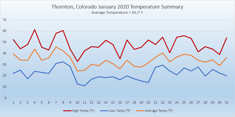
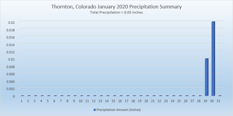
February in Colorado typically brings to an end an extended period when average temperatures are at their lowest. Winter begins to loosen its grip and temperatures get warmer but precipitation is not a particularly common event during the month.
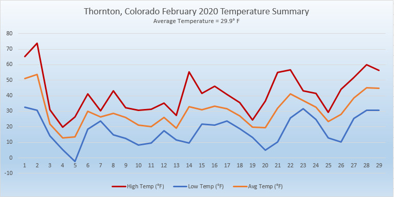
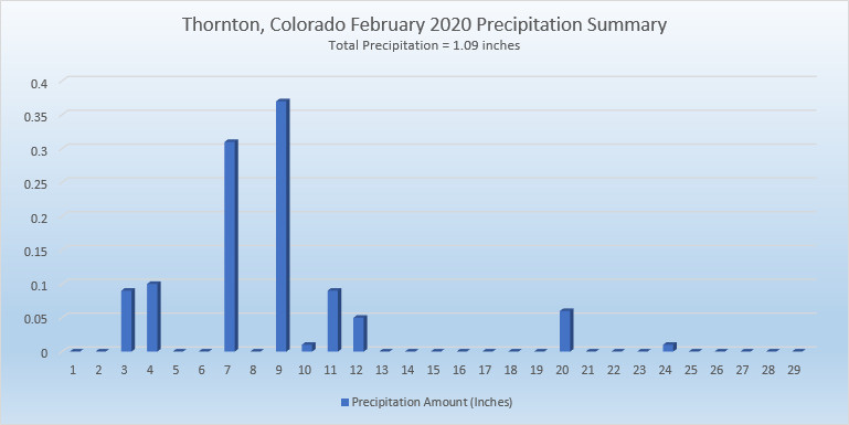
Thus far, our snow season has been a mixed bag. We started fast in October and November but December and January added very little to the totals.  February is only our sixth snowiest month so we may not see much snowfall for the balance of the month.

Temperatures however do usually see a nice rebound during the month. Average high temperatures climb from an average of 44 degrees at the start to 50 degrees by the end of February.

For the complete February preview including a look at historical averages and extremes as well as a look at what long range forecasts are predicting, click here. 

January 2020 weather recap: The year starts off warm and dry

After a cold and snowy start to the season in October and November, December saw things dry out and warm up. Unfortunately, January 2020 continued the most recent trend with temps well above normal and very little precipitation.

The month was largely uneventful with no notable weather events. Daytime high temperatures were routinely warmer than normal and no precipitation was seen until the very end of the month. When we did finally see some snow on the 29th and 30th, it was minimal, amounting to little more than a dusting.

Thornton’s overall average temperature for the month came in at 34.1 degrees. This is well above the long term Denver average for January of 30.7 degrees. As usual, the Mile High City’s official reading at Denver International Airport came in warmer than us at 34.6 degrees.

Temperatures in Thornton ranged from a high of 61.4 degrees on the 4th down to a low of 10.8 degrees on the 11th.  Denver saw its maximum reading of 62 degrees on the 4th and 8th and its lowest of 7 degrees on the 11th.

In terms of precipitation, Denver averages 0.27 inches in January. Both Thornton and Denver fell well short with 0.03 inches and 0.14 inches respectively.

Snow was in short supply with 0.6 inches falling in Thornton and 0.9 inches in Denver. Both were far short of the average of 7 inches for Denver in January.

In the end, the month was Thornton’s warmest, driest and least snowy January since ThorntonWeather.com came online in 2007.

Click here to view Thornton’s January 2020 climate report.

Thornton, Colorado's January 2020 temperature summary. Click for larger view. (ThorntonWeather.com)
Thornton, Colorado’s January 2020 temperature summary. Click for larger view. (ThorntonWeather.com)
Thornton, Colorado's January 2020 precipitation summary. Click for larger view. (ThorntonWeather.com)
Thornton, Colorado’s January 2020 precipitation summary. Click for larger view. (ThorntonWeather.com)

From the National Weather Service:

CLIMATE REPORT
NATIONAL WEATHER SERVICE DENVER/BOULDER CO
717 AM MST SAT FEB 1 2020

...................................

...THE DENVER CO CLIMATE SUMMARY FOR THE MONTH OF JANUARY 2020...

CLIMATE NORMAL PERIOD 1981 TO 2010
CLIMATE RECORD PERIOD 1872 TO 2020

WEATHER         OBSERVED          NORMAL  DEPART  LAST YEAR`S
                 VALUE   DATE(S)  VALUE   FROM    VALUE  DATE(S)
                                          NORMAL
................................................................
TEMPERATURE (F)
RECORD
 HIGH              76   01/27/1888
 LOW              -29   01/09/1875
HIGHEST            62   01/08        76     -14       62  01/04
                        01/04
LOWEST              7   01/11       -29      36       -5  01/01
AVG. MAXIMUM     48.0              44.0     4.0     44.6
AVG. MINIMUM     21.1              17.4     3.7     19.5
MEAN             34.6              30.7     3.9     32.0
DAYS MAX >= 90      0               0.0     0.0        0
DAYS MAX <= 32      1               5.5    -4.5        6
DAYS MIN <= 32     31              29.4     1.6       29
DAYS MIN <= 0 0 1.7 -1.7 1 PRECIPITATION (INCHES) RECORD MAXIMUM 2.35 1883 MINIMUM 0.01 1933 1934 1952 TOTALS 0.14 0.41 -0.27 0.75 DAILY AVG. 0.00 0.01 -0.01 0.02 DAYS >= .01         2               4.1    -2.1        6
DAYS >= .10         1               0.9     0.1        2
DAYS >= .50         0               0.0     0.0        0
DAYS >= 1.00        0               0.0     0.0        0
GREATEST
 24 HR. TOTAL    0.13   01/27

SNOWFALL (INCHES)
TOTALS            0.9               7.0              6.2   2019
RECORD           24.3   1992
TOTAL

DEGREE_DAYS
HEATING TOTAL     937              1063    -126     1016
 SINCE 7/1       3436              3531     -95     3388
COOLING TOTAL       0                 0       0        0
 SINCE 1/1          0                 0       0        0

FREEZE DATES
RECORD
 EARLIEST     09/08/1962
 LATEST       06/08/2007
EARLIEST                        10/07
LATEST                          05/05
.................................................................

WIND (MPH)
AVERAGE WIND SPEED              10.1
RESULTANT WIND SPEED/DIRECTION   4/220
HIGHEST WIND SPEED/DIRECTION    40/290    DATE  01/01
HIGHEST GUST SPEED/DIRECTION    53/290    DATE  01/01

SKY COVER
POSSIBLE SUNSHINE (PERCENT)   MM
AVERAGE SKY COVER           0.50
NUMBER OF DAYS FAIR           10
NUMBER OF DAYS PC             17
NUMBER OF DAYS CLOUDY          4

AVERAGE RH (PERCENT)     49

-  INDICATES NEGATIVE NUMBERS.
R  INDICATES RECORD WAS SET OR TIED.
MM INDICATES DATA IS MISSING.
T  INDICATES TRACE AMOUNT.