February in Colorado typically brings to an end an extended period when average temperatures are at their lowest. Winter begins to loosen its grip and temperatures get warmer but precipitation is not a particularly common event during the month.
Thus far our snow season is extraordinarily well in terms of snowpack with all basins in Colorado having well above normal levels. At lower elevations however, the snow season has been pretty poor due to a slow start. February is only our sixth snowiest month so we may not see much snowfall for the balance of the month.
Temperatures however do usually see a nice rebound during the month. Average high temperatures climb from an average of 44 degrees at the start to 50 degrees by the end of February.
Geese walk across a frozen Barr Lake with the snow-capped Rocky Mountains in the background. (Shawn Jones)
As one of our coldest months, January can be a good month to hibernate inside and avoid the outdoors. But, like any month in Colorado, photo opportunities abound as our monthly slideshow demonstrates.
Snow is not normally dominant in the month but when it does fall, it can create a beautiful blanket of white. Throw in the amazing sunrises and sunsets we receive in the middle of winter as well as wildlife and a host of other subjects and the imagery can be quite beautiful and stunning.
Slideshow updated January 31, 2017
To learn more about how to send your photo to us for inclusion in the slideshow, see below the slideshow.
Showcasing images captured by ThorntonWeather.com readers as well as some of our own, our monthly slideshow covers the entire gamut of weather-related imagery.
Sunsets, sunrises, wildlife and of course every type of weather condition are vividly depicted in images captured from yours and our cameras.
[flickr_set id=”72157679397821116″]
What is missing in the slideshow above? Your photo!
Our monthly photo slideshow is going to feature images that we have taken but more importantly images that you have captured. The photos can be of anything even remotely weather-related.
Landscapes, current conditions, wildlife, pets, kids. Whimsical, newsy, artsy. Taken at the zoo, some other area attraction, a local park, a national park or your backyard. You name it, we want to see and share it!
Images can be taken in Thornton, Denver or anywhere across the extraordinary Centennial State. We’ll even take some from out of state if we can tie it to Colorado somehow.
We’ll keep the criteria very open to interpretation with just about any image eligible to be shown in our slideshows.
What do you win for having your image in our slideshow? We are just a ‘mom and pop’ outfit and make no money from our site so we really don’t have the means to provide prizes. However you will have our undying gratitude and the satisfaction that your images are shared on the most popular website in Thornton.
To share you images with us and get them included in the slideshow just email them to us or share them with ThorntonWeather.com on any of the various social media outlets. Links are provided below.
Thornton resident Shannon Dizmang put his camera to good use and captured a stunning time lapse video of some lenticular clouds that developed this afternoon.
Also known by their scientific name of altocumulus standing lenticularis, these clouds are not entirely unusual in Colorado on the Front Range during the winter. Strong jet winds force moist air to be pushed up by the rugged terrain of the adjacent Rocky Mountains. This creates a wave-like pattern of air flow that condenses at high altitudes (usually around 20,000 feet).
January 29 to February 4: This Week in Denver Weather History
You just never know what you are going to get with the weather in Denver and we see that in our look back at the Denver weather history books. From cold and snow to damaging winds and spring-like temperatures, we can and do see it all.
From the National Weather Service:
26-1
In 1888…a protracted warm spell lasted a week. Maximum temperatures ranged from 62 degrees on the 29th to an all time record high for the month of 76 degrees on the 27th. Daily record high temperatures of 76…69…and 71 occurred on the 27th…28th…and 30th respectively. Record high minimum temperatures of 47 and 34 occurred on the 26th and 27th.
27-31
In 1951…a major storm dumped 10.1 inches of snowfall at Stapleton Airport. Most of the snow…8.3 inches…fell on the 29th. Cold arctic air accompanied the snow. Several temperature records were set…including record low maximum temperatures of 4 on the 28th and 4 below zero on the 29th and record low temperatures of 12 below zero on the 29th and 24 below zero on the 31st. Temperatures were below zero for 45 consecutive hours.
28-29
In 1956…snowfall totaled 5.5 inches at Stapleton Airport where east winds gusted to 32 mph on the 28th.
In 1972…cold west winds buffeted Boulder. A wind gust to 92 mph was recorded at the National Bureau of Standards…while a gust to 76 mph was measured in downtown Boulder. Two mobile homes were overturned in Boulder. Other damage was minor. Northwest winds gusted to 40 mph at Stapleton International Airport on the 28th.
In 1987…strong winds buffeted the Front Range foothills and spread east over the plains. The highest wind recorded was 99 mph on the 29th at both the National Center for Atmospheric Research in Boulder and the Rocky Flats plant south of Boulder. Wind gusts in excess of 80 mph were common. A northwest wind gust to 54 mph was recorded at Stapleton International Airport on the 28th with a gust to 41 mph on the 29th. Planes were damaged at both the Boulder and Jefferson County Airports. Hangars were also damaged at Jefferson County Airport. Many windows were broken…signs toppled…and trees downed. A brick wall was blown onto parked cars in Lakewood. A couple of houses in Lakewood were unroofed…while falling trees damaged others. Two people were injured by flying debris in Lakewood and Golden. Total insured damage along the Front Range was 10 million dollars making the wind storm the second most costly on record in Colorado at the time.
In 1995…deepening upslope winds along the eastern foothills on the 28th gave way to periods of heavy snow during the night and early morning hours of the 29th. Snow fell to a depth of 8 inches in both Golden and Boulder with up to a foot in the foothills. Only 1.9 inches of snow fell at Stapleton International Airport…where east winds gusted to 22 mph on the 28th.
In 2001…heavy snow fell across metro Denver. The heaviest snowfall occurred from just south of Denver to around Castle Rock. Snow amounts included: 12 inches east of Parker…9 inches near Elizabeth and in Littleton…8 inches near Castle Rock and in Parker…and 7 inches in Aurora. Snowfall totaled 6.0 inches at the site of the former Stapleton International Airport.
28-30
In 1887…winds were strong and gusty for three days in the city. West and northwest winds were sustained to 56 mph on both the 28th and 29th and to 44 mph on the 30th. Temperatures warmed to a high of 57 degrees on the 29th.
29
In 1900…northwest winds were sustained to 45 mph with an extreme velocity of 46 mph.
In 1914…this was the last day of 60 consecutive days with snow cover of one inch or more in Denver. This third longest period of snow cover on record began with the record breaking snow and blizzard on December 1-5… 1913 when a total of 45.7 inches of snow fell in downtown Denver. Additional snowfall during December and January prolonged the event. Snow depth on the ground to the nearest tenth of an inch was measured once daily at 6:00 pm MST.
In 1927…west winds were sustained at 40 mph with gusts to 42 mph.
In 1942…heavy snowfall totaled 6.2 inches in downtown Denver. North winds were sustained to 17 mph.
In 1965…strong winds occurred in Boulder for the third consecutive day. Only limited minor damage was reported. Northwest winds gusted to 40 mph at Stapleton International Airport.
In 1984…highs winds in and near the foothills produced wind gusts as high as 71 mph in Boulder. A plane was flipped over at Jefferson County Airport and damaged beyond repair. In Lakewood…two construction trailers were damaged by the gusts. North winds gusted to only 38 mph at Stapleton International Airport.
In 1990…gale to hurricane force winds gusts raked the foothills. Wind gusts of 50 to 90 mph were common in Boulder County. A peak wind of 94 mph was clocked at Table Mesa in southwest Boulder. Scattered power outages and minor property damage were reported. West winds gusted to 46 mph at Stapleton International Airport.
29-30
In 1985…an arctic air mass with snow closed I-70 for a time in Denver and east of Denver. Snowfall totaled 5.4 inches at Stapleton International Airport where north winds gusted to 29 mph on the 29th.
29-31
In 1883…a major winter storm dumped 19.3 inches of snow on downtown Denver. Most of the snow…12.2 inches…fell on the 31st. This was the heaviest snowfall to hit the city in years. Temperatures plunged from a high of 52 degrees on the 29th to a low of 13 degrees on the 31st. Precipitation from the storm totaled 2.23 inches. The 1.22 inches of precipitation on the 31st was the greatest calendar day and 24 hour precipitation ever recorded in the city during the month of January.
30
In 1886…west winds were sustained to 42 mph and were the strongest winds of the month that year. The winds warmed the temperature to a high of 52 degrees in the city.
In 1890…west winds were sustained to 40 mph with gusts to 48 mph in the city.
In 1971…a wind gust to 102 mph was recorded in Boulder at the National Center for Atmospheric Research. Elsewhere in Boulder…winds gusted to 76 mph. Northwest winds gusting to 46 mph at Stapleton International Airport warmed temperatures to a high of 66 degrees.
In 1976…a rapid moving cold front produced wind gusts 50 to 70 mph causing visibilities to be reduced to less than 1/2 mile in blowing dust for 1 to 2 hours closing some major highways. A north wind gust to 55 mph was recorded at Stapleton International Airport.
In 2003…strong winds developed in and near the foothills. Recorded wind gusts included: 86 mph near Rollinsville… 76 mph in Evergreen…and 75 mph in central Boulder. West winds gusted to 43 mph at Denver International Airport.
30-31 in 1908…an apparent strong cold front plunged temperatures 45 degrees in 24 hours from 47 degrees at noon on the 30th to only 2 degrees at noon on the 31st. North winds were sustained to 30 mph on the 30th. Snowfall was only 0.8 inch on the 31st.
In 1965…a major storm dumped 10.4 inches of snow over metro Denver. After 5 inches of snow fell in Boulder… Strong Chinook winds developed…warming the temperature 25 degrees in 90 minutes. Wind gusts to 97 mph were recorded on Table Mountain in Boulder. Winds gusts to 53 mph were measured in downtown Boulder where some damage occurred. Minor wind damage also occurred in western suburbs of Denver. West winds gusted to 51 mph at Stapleton International Airport on the 31st.
In 2005…a winter storm brought heavy snow to the Front Range foothills. Storm totals included: 17 inches at Aspen Springs…13 inches 7 miles southwest of Boulder and at Lake Eldora…12.5 inches near Blackhawk…11.5 inches at Rollinsville and near Nederland…11 inches near Evergreen and Golden and at Gross Reservoir…and 10 inches at cabin creek. Lesser amounts of snow fell over the city. Only 1.9 inches of snow were measured overnight at Denver Stapleton. North winds gusted to 30 mph at Denver International Airport…where freezing fog during the early morning of the 30th reduced the surface visibility to as low as 1/8 mile. Light rainfall… Rare in January…totaled 0.06 inch at Denver Stapleton on the early morning of the 30th.
30-7
In 1985…a cold front on the 29th produced a protracted cold spell as arctic air remained entrenched across metro Denver. While the only daily temperature record set was a low maximum reading of 2 degrees on February 3rd…minimum temperatures plunged well below zero on 9 consecutive days. The coldest readings were 15 degrees below zero on January 31st and 14 degrees below zero on February 5th.
31
In 1876…hurricane force winds caused some damage in Boulder.
In 1951…the low temperature plunged to 24 degrees below zero.
In 1933…snowfall was 0.2 inch in downtown Denver. This was the only measurable snowfall of the month and resulted in 0.01 inch of melted snow…the only measurable precipitation of the month.
In 1964…high winds blew down a sidewalk cover where a building was under construction…injuring a young woman. Three men were injured when a brick wall at a construction site toppled on them. All were treated for face…leg…and neck injuries. A west-northwest wind gust to 47 mph was recorded at Stapleton International Airport.
In 1969…high winds struck Boulder with gusts to 115 mph recorded at the National Center for Atmospheric Research and 83 mph in downtown Boulder. Schools were closed because of danger from flying debris. Some damage and minor injuries occurred. Northwest winds gusted to 35 mph at Stapleton International Airport.
In 1985…bitterly cold weather froze pipes and cars and forced some schools to close across metro Denver. Minimum temperatures dipped to as low as 15 below to 20 below zero across metro Denver. The low temperature was 15 below zero at Stapleton International Airport.
31-1
In 1963…high winds struck metro Denver. The strong Chinook winds reached 101 mph in Littleton…80 mph in Denver…and 90 mph at Rocky Flats. Among the hardest hit areas were Boulder where buildings under construction were blown down…porches and roofs blown off buildings…and power lines damaged. Damage totaled 100 thousand dollars in Boulder alone. In other areas…utility lines were damaged and many signs…antennas…and road markers were blown down. At Stapleton Airport…west winds gusted to 44 mph on the 31st and 66 mph on the 1st. The Chinook winds warmed maximum temperatures to 65 degrees on the 31st and to 70 degrees on the 1st.
31-8
In 1963…warm weather that began with the strong Chinook winds on the 31st and 1st continued through the 8th. Maximum temperatures through the period ranged from 52 degrees on the 2nd to 76 degrees on the 5th…which was a new record high for that date.
31-12
In 1899…a protracted cold spell lasted almost two weeks. Low temperatures plunged below zero on all days but February 9th with a reading of 6 degrees. The coldest low temperature of 22 degrees below zero on February 6th was a record low for the date. Low temperatures of 20 degrees below zero occurred on both February 11th and 12th… But only the 11th remains as the record minimum for the date. High temperature of only 5 degrees below zero on February 11th was a record low maximum for the date. High temperatures climbed to only zero degrees on both February 2nd and 3rd…but were not records. Intermittent light snow or flurries fell during the period. The most snowfall…2.0 inches…occurred on February 2nd.
1
In 1904…northwest winds were sustained to 51 mph with gusts to 60 mph. The Chinook winds warmed the temperature to a high of 55 degrees.
In 1907…west winds sustained to 42 mph warmed the temperature to a high of 59 degrees.
In 1932…the temperature rose from a low of 8 degrees at 7:00 am to the high of 58 degrees at 2:30 pm. The biggest jump occurred from 16 degrees at 8:00 am to 42 degrees at 9:10 am.
In 1951…the lowest recorded temperature in February…25 degrees below zero…occurred. The same temperature was also reached on February 8…1936.
In 1963…west-southwest winds gusted to 66 mph at Stapleton Airport where the strong Chinook winds warmed the temperature to a maximum of 70 degrees.
In 1970…snowfall of 0.3 inch contained only 0.01 inch of melted snow. This was the only measurable snow and precipitation for the month…making it the driest and least snowiest February on record. Snowfall also was only 0.3 inch on February 22-23…1992…equaling the least snowiest February.
In 1980…high winds occurred in the foothills. Wind gusts to 75 mph were reported at Wondervu. Northwest winds gusted to 32 mph at Stapleton International Airport.
In 1995…a short blast of early morning winds near the foothills produced a gust to 64 mph at Rocky Flats in northern Jefferson County. Winds gusting to 59 mph in Lakewood downed a few tree branches in residential areas. West winds gusted to 37 mph at Stapleton International Airport where the warm winds kept the temperature from falling below 43 degrees…setting a new record high minimum for the date. The temperature climbed to a non-record high of 63 degrees.
1-2
In 1934…light Chinook winds warmed temperatures to record levels on both days. Record maximum temperatures reached 73 degrees on the 1st and 74 degrees on the 2nd. West winds were sustained to 18 mph on the 1st.
1-3
In 1996…cold arctic air plunged temperatures below zero for more than 35 consecutive hours from late on the 1st until sunrise on the 3rd. The temperature warmed to only 1 degree below zero on the 2nd after a record low of 16 degrees below zero.
1-4
In 2011…a frigid arctic airmass settled into Front Range urban corridor. At Denver International Airport… Overnight low temperatures…from the 1st to the 3rd… Were 13 below zero…17 below zero and zero respectively. The icy temperatures caused pipes to crack and burst following the freeze. In Loveland…firefighters responded to more than a dozen water pipe breaks…most in fire sprinkler systems at businesses…apartments and assisted care facilities. At cu earth science library in Boulder…more than 1000 books and several costumes for an upcoming production were damaged. At the county courts administration building in Jefferson County…a steady stream of water from a crack on the 5th floor… Went unnoticed on the 3rd and flooded all the floors of the administration wing overnight. As a result…much of the office equipment…furniture and carpet sustained water damage. A burst sprinkler line caused minor damage at the Platte Valley Medical Center in Brighton. The icy temperatures forced to closure of several school districts as well.
1-5
In 1985…the most bitter cold spell of the winter season brought sub-zero temperatures to metro Denver. Daily low temperature records were broken at Denver. The usual cold weather problems struck including stalled vehicles…jammed traffic lights…and frozen water and sewer lines. At Stapleton International Airport…the high temperature was only 2 degrees above zero on the 1st…setting a record low maximum for the date. Low temperatures reached 13 below zero on the 1st…12 below on the third…and 14 below on the 5th.
1-6
In 1989…one of the century’s worst doses of winter weather ravaged the entire state. Bitterly frigid weather moved into metro Denver on the 1st as snow buried many sections of the state. In metro Denver where 3 to 6 inches of snow fell…blowing snow and resultant poor visibilities caused a 46-car pile-up on I-25 in the middle of the city on the 4th. During the period…2 to 3 hour delays were common at Stapleton International Airport where snowfall from the storm totaled 4.3 inches and northeast winds gusted to 30 mph on the 1st. Intense cold accompanied the storm. Temperatures in Denver stayed below zero continuously for the best part of 3 days (3rd…4th…5th)…for a total of 69 hours. This is the fourth longest sub-zero period on record. Wind chill temperatures reached 50 degrees below zero. The mercury dipped to 24 degrees below zero on the 5th…setting a record for the date. This was the city’s coldest temperature in over 26 years. Low temperatures dipped below zero on 8 consecutive days (2nd-9th). High temperature of 9 degrees below zero on the 4th was a record low maximum for the date…as was the high of 5 degrees on the 5th. Extensive damage occurred when pipes and water lines froze and broke. Thousands of cars failed to start. On the 3rd…a 57-year-old woman died of hypothermia in an Arvada park. Eighteen high school students were treated for hypothermia after a 2-hour ride through Jefferson County in an unheated bus. At least 2 cases of frostbite were reported; there were undoubtedly many more.
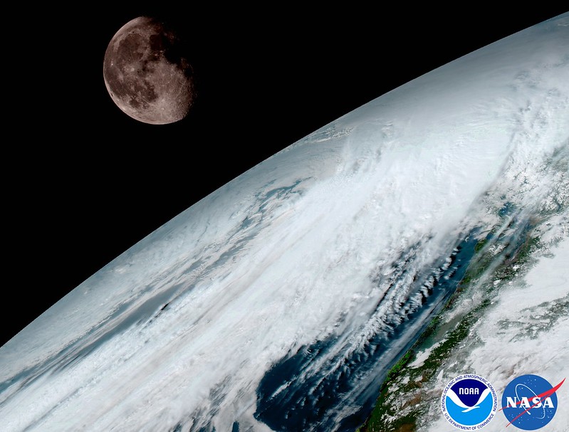
GOES-16 captured this view of the moon as it looked across the surface of the Earth on January 15. Like earlier GOES satellites, GOES-16 will use the moon for calibration. (NOAA/NASA)
NOAA released the first images from their new GOES-16 satellite and to say they are stunning would be an understatement. The new satellite, built in Colorado by Lockheed Martin, contains some of the highest resolution cameras and most advanced sensors in the world.
From NOAA:
Since the GOES-16 satellite lifted off from Cape Canaveral on November 19, scientists, meteorologists and ordinary weather enthusiasts have anxiously waited for the first photos from NOAA’s newest weather satellite, GOES-16, formerly GOES-R.
The release of the first images today is the latest step in a new age of weather satellites. It will be like high-definition from the heavens.
Scroll down to view all of the new images released by NOAA
The pictures from its Advanced Baseline Imager (ABI) instrument, built by Harris Corporation, show a full-disc view of the Western Hemisphere in high detail — at four times the image resolution of existing GOES spacecraft. The higher resolution will allow forecasters to pinpoint the location of severe weather with greater accuracy. GOES-16 can provide a full image of Earth every 15 minutes and one of the continental U.S. every five minutes, and scans the Earth at five times the speed of NOAA’s current GOES imagers.
NOAA’s GOES-16, situated in geostationary orbit 22,300 miles above Earth, will boost the nation’s weather observation network and NOAA’s prediction capabilities, leading to more accurate and timely forecasts, watches and warnings.
“This is such an exciting day for NOAA! One of our GOES-16 scientists compared this to seeing a newborn baby’s first pictures — it’s that exciting for us,” said Stephen Volz Ph.D. director of NOAA’s Satellite and Information Service. “These images come from the most sophisticated technology ever flown in space to predict severe weather on Earth. The fantastically rich images provide us with our first glimpse of the impact GOES-16 will have on developing life-saving forecasts.”
In May, NOAA will announce the planned location for GOES-16. By November 2017, GOES-16 will be operational as either GOES-East or GOES-West. Once operational, NOAA will use the satellite’s six new instruments to generate new or improved meteorological, solar, and space weather products.
Second satellite in GOES series already in development
Following on the heels of GOES-R will be, GOES-S, the second of four spacecraft in the series. GOES-S is undergoing environmental testing at Lockheed Martin’s Corporation facility in Littleton, Colorado, where it was built. A full set of environmental, mechanical and electromagnetic testing will take about one year to complete. The GOES-S satellite will be moved into the other operational position as GOES-17 immediately after launch and initial checkout of the satellite, approximately nine months after GOES-16.
LOS ANGELES — The third in a series of powerful winter storms unleashed a deluge in Southern California on Sunday, flooding numerous roads and freeways, setting new rainfall records and stranding some in dangerously rising waters. Forecasters had predicted this storm would be the strongest in several years, and it didn’t disappoint. While earlier storms produced… Continue reading Record rainfall hits Southern California→
January 22 to January 28: This Week in Denver Weather History
Protracted cold spells, damaging and injuring winds and heavy snowfall mark our look back at this week in Denver weather history.
From the National Weather Service:
15-23
In 1962…a protracted cold spell kept metro Denver in the deep freeze for more than a week. From the 15th thru the 23rd…low temperatures were zero or below for 9 consecutive days…but a daily record low was set only on the 22nd when the temperature dipped to 14 degrees below zero. A record low maximum for the date was also set on the 22nd when the temperature climbed to only 11 degrees. The coldest high temperature was 3 degrees above zero on the 21st…which did not break the record. The protracted cold was broken for only a few hours on the afternoon of the 20th when Chinook winds warmed the temperature to a high of 38 degrees before another surge of cold arctic air plunged temperatures back into the deep freeze that evening. The severe cold caused much damage to water systems. A woman was frozen to death at Morrison. There were other deaths attributable to the weather…including traffic deaths and heart attacks from overexertion.
18-24
In 2005…a week of mid-winter unseasonably warm weather pushed high temperatures into the 60’s or more on all but one day. During the period…the highest temperature of 70 degrees on the 20th was a new record maximum for the date. Low temperatures remained above freezing on 4 of the days.
20-22
In 1937…a second incursion of cold arctic in less than two weeks kept temperatures in the deep freeze for three days… Even though only one temperature record was set during the period. Temperatures were below zero for an estimated 53 consecutive hours. The below zero period would have been longer had the temperatures on the 20th not climbed to a high of 1 degree after a low of 8 degrees below zero. On the 21st…the high temperature of 1 degree below zero was a record low maximum for the date. Low readings on both the 21st and 22nd were 9 degrees below zero.
In 1971…high winds raked Boulder. Wind gusts to 77 mph were recorded at the National Center for Atmospheric Research. Winds gusted to 83 mph in south Boulder and to 68 mph in downtown Boulder. Minor personal injuries occurred…and reported damage to structures totaled 15 thousand dollars. On the 21st…northwest winds gusted to 44 mph at Stapleton International Airport. The Chinook winds warmed the temperature to a high of 69 degrees on the 20th…which equaled the record for the date.
In 1993…sporadic high winds along the east slopes of the Front Range during the early morning hours of the 20th moved onto the foothills and plains by the 22nd. Wind gusts of 55 to 65 mph were common. Some significant wind reports included 82 mph at Rollinsville and atop Squaw Mountain west of Denver…and 75 mph on Rocky Flats. At Stapleton International Airport…west winds gusted to 35 mph on the 20th…44 mph on the 21st…and 55 mph on the 22nd.
21-22
In 1972…wind gusts to 74 mph were recorded at the National Bureau of Standards in Boulder…while in downtown Boulder wind gusts to 56 mph were measured. The strong winds overturned a plane at the Arapahoe County airport. A motorcyclist died of injuries when he was blown off a Boulder County road. Northwest winds gusted to 39 mph at Stapleton International Airport on the 21st.
In 1999…heavy snow developed across portions of metro Denver and in the foothills. Snowfall totals included: 8 inches in Golden Gate Canyon…Intercanyon…Rollinsville… And Parker; 7 inches at Aspen Springs…Gross Reservoir… Pine Junction…and 5 miles south of Sedalia; 6 inches at Highlands Ranch; and 5 inches at Eaglecrest…Eldorado Springs…and Louisville. Snowfall totaled 2.6 inches at the site of the former Stapleton International Airport. On the 21st…north-northwest winds gusted to 31 mph at Denver International Airport.
22
In 1899…a cold front produced northeast sustained winds to 50 mph with gusts to 60 mph in the city.
In 1951…a heavy windstorm struck Boulder. Minor damage was reported. Strong post-frontal east winds gusted to 45 mph at Stapleton Airport.
In 1990…strong winds of 50 to 90 mph buffeted the foothills. No significant damage was reported. West winds gusted to 37 mph at Stapleton International Airport.
In 1992…strong winds raked the eastern foothills with a wind gust to 58 mph recorded at Rocky Flats just northwest of Denver. West winds gusted to only 25 mph at Stapleton International Airport.
In 2003…only a trace of snow fell at the site of the former Stapleton International Airport. This along with a trace of snow on the 1st was the only snow of the month…which equaled the record for the least snowiest January first set in 1934.
22-23
In 1982…wind gusts up to 101 mph were clocked at Wondervu. Wind gusts of 60 to 80 mph were common along the Front Range foothills from Boulder north.
22-26
In 1948…the longest period of snowfall on record (92 hours and 3 minutes) occurred in downtown Denver where a total of 13.6 inches of snow fell. At Stapleton Airport…19.0 inches of snow fell…making it the heaviest snow in January and the 5th heaviest snow of record at that time. North winds were sustained to a velocity of 23 mph on the 25th…but generally the winds were light throughout the storm. The snow disrupted traffic…but street clearing was begun soon after it became apparent that the snow would be heavy. Over the 5 days…temperatures ranged from a high of 48 degrees on the 22nd to a low of 1 degree on the 26th. Most readings were in the teens and 20’s during the storm.
23
In 1872…a brisk northerly wind set in about noon…blew almost a gale about 6:00 pm…and continued brisk until night. A light snow commenced during the late afternoon and continued all night.
In 1886…northwest winds were sustained to 40 mph in the city around sunrise. A cold wave accompanied the strong winds.
In 1897…a vigorous cold front produced northeast winds sustained to 45 mph with gusts to 50 mph. Temperatures plunged from a high of 59 degrees to a low of 11 degrees in the evening. The very cold temperatures persisted through the 28th.
In 1934…the date marked the last day of the longest period of consecutive days without measurable precipitation in the city. The 52 day period began on December 3…1933.
In 1988…one of the strongest windstorms in several years pounded the Front Range foothills from Colorado Springs north to the Wyoming border. The highest wind gust at lower elevations was 105 mph recorded at Table Mesa in Boulder. Other sections of Boulder recorded wind gusts of 80 to 90 mph. In Boulder…the high winds broke windows and damaged power lines and transformers. Power outages were widespread and traffic lights were downed. The winds blew down a partially constructed viaduct in east Boulder. Nine unanchored concrete girders…each weighing 45 tons…were blown off their supports. Cars were blown off I-70 near Morrison…and a tractor trailer and a mobile home were knocked over. In Lakewood…an electric company crewman was burned while replacing a power line. Wind gusts to 92 mph were clocked at Jefferson County Airport in Broomfield before the site anemometer was blown down by the wind. The strong winds spread over all the metro area with a northwest wind gust to 52 mph recorded at Stapleton International Airport.
In 1992…high winds buffeted the eastern foothills. A wind gust to 63 mph was recorded at Rocky Flats northwest of Denver. West winds gusted to 40 mph at Stapleton International Airport.
In 2002…low level upslope flow combined with an upper level jet stream created bands of heavy snow over portions of the Front Range foothills and metro Denver. The areas hardest hit were the foothills of Jefferson and Douglas counties and the I-25 corridor from the southern suburbs of Denver to around Castle Rock. Snow totals included: 9 inches at Intercanyon…Roxborough State Park…and near Sedalia; 8.5 inches atop Crow Hill and near Tiny Town; 8 inches at Ken Caryl and near Castle Rock; 7 inches in Lakewood; 6.5 inches at Littleton; and 6 inches in Castle Rock. Only 3.6 inches of snow were measured at the site of the former Stapleton International Airport.
23-24
In 1921…heavy snowfall in downtown Denver totaled 8.0 inches overnight. Northwest winds were sustained to 22 mph with gusts to 25 mph on the 24th.
Severe thunderstorms and tornados threatened Florida, Georgia and North Carolina Sunday night as heavy winds, large hail and rains hit the Southeast coast and killed at least 16 people. Residents were urged to seek safe shelter and listen to their radios for any emergency warnings. “There is a significant risk for large, long-tracked and extremely destructive… Continue reading Death Toll Climbs As Unusual Weather Hits Florida, Georgia, Mississippi, Carolinas→
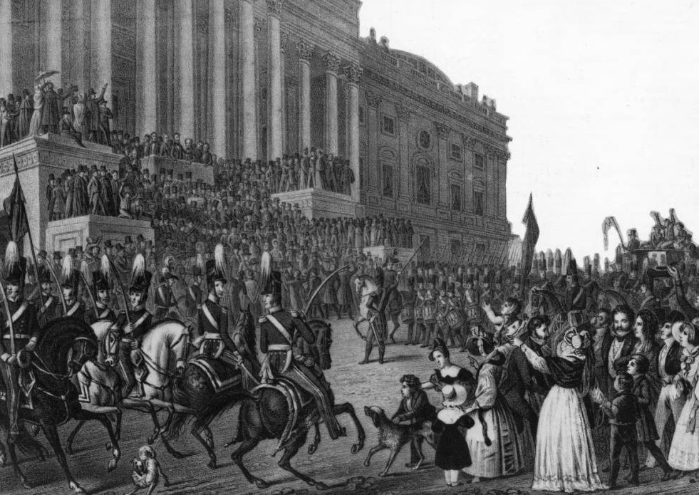
By far the most tragic inaugural weather was in 1841 when William Henry Harrison contracted pneumonia and died a month later. Image courtesy the Library of Congress.
On a cold, wet and blustery day, the new President of the United States prepared to take office. He rode a horse to and from the Capitol that day and spoke on the steps of the building for nearly two hours – all without an overcoat or so much as a hat.
William Henry Harrison’s refusal to acknowledge the realities of the harsh weather on March 4, 1841 would be his demise. Our nation’s newest president would also have the shortest presidency, a mere 30 days, as he caught a chill that day which then turned to pneumonia and would claim his life.
Weather in the winter can be a wildcard to say the least and it has been a point of consternation for inauguration festivities. In President Harrison’s day, we inaugurated our new leader in March but since 1937 Inauguration Day has been held on January 20th, a day which puts it right in the potentially coldest part of winter.
‘Normal’ weather for January 20th in Washington D.C. actually isn’t all that bad. The city usually reaches a high temperature in the low 40’s. At noon, the appointed time for the inaugural address, the normal temperature is 37 degrees with partly cloudy skies and a 10 mph wind. According to the National Weather Service there is historically a 1 in 20 chance of snowfall on the date itself. Not too bad at all.
Like President Harrison, some other presidents weren’t very lucky when it came to the weather on inauguration day.
100 years ago President William Howard Taft famously said, “I knew it would be a cold day when I made president,” and he was absolutely right. On that March day ten inches of snow fell and wind downed trees and power poles as streets became clogged and trains stalled. President Taft’s ceremony was moved indoors due to poor weather and historians consider the day the worst inaugural weather ever.
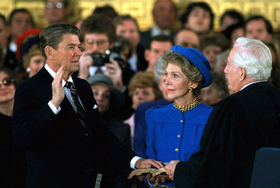
“President Ronald Reagan’s swearing in was the coldest in history but there has been other notable weather on Inauguration Day. (White House)
President Taft had it rough but his inauguration wasn’t the coldest. For his second inauguration President Ronald Reagan saw truly Arctic cold temperatures impact his ceremony. At noon in 1985 it was a mere 7 degrees and the wind chill dropped that to between -10 and -20 degrees. Like Taft, President Reagan’s inauguration was moved indoors.
In 1873 when Ulysses S. Grant prepared to take office for his second term, the temperature was a mere 16 degrees at noon. The wind was so bad it made his inaugural address inaudible to everyone including those on the platform with him.
In 1961 on the eve of John F. Kennedy’s inauguration, eight inches of snow fell causing the worst inaugural traffic jam as hundred of cars were stuck and thousands abandoned. The temperature only reached 22 degrees that day and the new president was forced to cancel dinner plans as travel was so difficult.
As for rain, that too can intrude on one of our nation’s most revered occasions. 1.77 inches of rain fell on January 20, 1937 – a record for the date that still stands today. President Franklin Delano Roosevelt rode in a convertible back to the White House after the inauguration which had a half-inch of water on the floor by the time he arrived.
How are things looking for Inauguration Day 2017 and President-elect Donald Trump’s swearing in? Rain looks to be a virtual certainty for much of the morning right through the swearing in at 12:00 noon EST / 10:00am MST. The actual volume of precipitation though does not look like it will be all that great. Temperatures will be topping out a bit warmer than normal for the date with an expected high of 48 degrees. Click here for the latest forecast for Washington DC from the National Weather Service.
Another year in the books for us and as we look back on our overall weather for 2016, we see overall temperatures were warmer than normal while precipitation fell a good bit short of normal. The year did seem to lack any major drama in terms of severe weather or winter storms which is likely a good thing.
We started out with above normal temperatures for the first quarter of the year. March, as usual, was our snowiest month and also became our wettest month of the year. April followed with some snow and a good bit of rain to be our second wettest and May the third.
May also saw much cooler than normal temperatures with the biggest departure from normal. From there, drier conditions reigned through November with each month registering below normal precipitation.
October and November saw our biggest deviations from normal temperatures as high pressure dominated and we saw extraordinarily warm conditions. This changed in December as Arctic air infiltrated the region leading to well below normal temperatures.
Overall, Thornton’s annual temperature came in at 51.6 degrees. This was 1.1 degrees above Denver’s 30 year average (1981 to 2010) of 50.5 degrees. We saw readings ranging from a high of 100.4 degrees down to a low of 10.7 degrees below zero. Fifty days saw 90 degrees or higher while at the opposite end we saw 169 days with readings at or below freezing.
Out at DIA where the Mile High City’s official measurements are kept, it was warmer with an annual average of 52.3 degrees. For Denver, that ranks as the 14th warmest year in its 145 year temperature history.
In terms of precipitation, Denver averages 14.3 inches per calendar year. Both Thornton and Denver fell well short of that mark with 12.98 inches and 11.85 inches respectively. For Denver, that is the 37th driest year on record.
Thornton saw a very respectable 68.1 inches for the calendar year. At the airport Denver saw less with 61.6 inches. Both were well above the annual average of 53.8 inches.
Thornton, Colorado’s annual temperature summary for 2016.Thornton, Colorado’s annual precipitation summary.
From the National Weather Service:
CLIMATE REPORT
NATIONAL WEATHER SERVICE DENVER/BOULDER CO
1010 AM MST SUN JAN 1 2017

...................................

...THE DENVER CO CLIMATE SUMMARY FOR THE YEAR OF 2016...

CLIMATE NORMAL PERIOD 1981 TO 2010
CLIMATE RECORD PERIOD 1872 TO 2016

WEATHER         OBSERVED          NORMAL  DEPART  LAST YEAR`S
                 VALUE   DATE(S)  VALUE   FROM    VALUE  DATE(S)
                                          NORMAL
................................................................
TEMPERATURE (F)
RECORD
 HIGH             105   06/26/2012 06/25/2012
                        07/20/2005 08/08/1878
 LOW              -29   01/09/1875
HIGHEST           102   07/10/2016                   98  08/15
LOWEST            -15   12/17/2016                  -10  01/04
AVG. MAXIMUM     66.7              64.7     2.0     65.4
AVG. MINIMUM     38.0              36.3     1.7     38.6
MEAN             52.3              50.5     1.8     52.0
DAYS MAX >= 90     55              39.6    15.4       48
DAYS MAX <= 32     14              20.0    -6.0       29
DAYS MIN <= 32    138             156.9   -18.9      126
DAYS MIN <= 0 4 5.8 -1.8 7 PRECIPITATION (INCHES) RECORD MAXIMUM 23.31 1967 MINIMUM 7.29 2008 TOTALS 11.85 14.30 -2.45 18.31 DAILY AVG. 0.03 0.03 0.00 0.05 DAYS >= .01        71              79.7    -8.7      107
DAYS >= .10        32              34.9    -2.9       49
DAYS >= .50         5               7.6    -2.6       10
DAYS >= 1.00        2               2.3    -0.3        2
GREATEST
 24 HR. TOTAL    1.38   2016                5/26 TO 5/27
                 1.22   2016                4/15 TO 4/16
                 0.77   2016                3/23 TO 3/23
SNOWFALL RECORDS JANUARY THROUGH DECEMBER TOTALS
               MAXIMUM           MINIMUM
                115.9   1913       18.9    1887
                112.0   1959       21.5    1888
                 99.2   1929       21.8    1890
 24 HR TOTAL     23.6   12/24/1982 TO 12/24/1982

TOTALS           61.6              53.8     7.8     64.4
 LIQUID EQUIV    6.16              5.40    0.76     6.44
SINCE 7/1        11.4              22.5   -11.1     22.6
 LIQUID 7/1      1.14              2.20   -1.06     2.26
SNOWDEPTH AVG.      0                MM      MM        0
DAYS >= TRACE      37              33.3     3.7       51
DAYS >= 1.0        13              16.3    -3.3       25
GREATEST
 SNOW DEPTH        10   03/24                          9  02/23
 24 HR TOTAL     13.1   03/23
                 11.8   04/16
                  6.9   02/01

 STORM TOTAL     13.1   03/23

DEGREE_DAYS
HEATING TOTAL    5415              6059    -644     5479
 SINCE 7/1       2042              2468    -426     5575
COOLING TOTAL     878               769     109      877
 SINCE 1/1        878               769     109      877

FREEZE DATES
RECORD
 EARLIEST     09/08/1962
 LATEST       06/08/2007
EARLIEST                        10/07
LATEST                          05/05
..................................................

WIND (MPH)
AVERAGE WIND SPEED              10.0
RESULTANT WIND SPEED/DIRECTION   2/194
HIGHEST WIND SPEED/DIRECTION    54/340    DATE  07/24
HIGHEST GUST SPEED/DIRECTION    74/340    DATE  07/24

SKY COVER
POSSIBLE SUNSHINE (PERCENT)   MM
AVERAGE SKY COVER           0.50
NUMBER OF DAYS FAIR           94
NUMBER OF DAYS PC            210
NUMBER OF DAYS CLOUDY         62

AVERAGE RH (PERCENT)     50

WEATHER CONDITIONS. NUMBER OF DAYS WITH
THUNDERSTORM              0     MIXED PRECIP               0
HEAVY RAIN                3     RAIN                      13
LIGHT RAIN               72     FREEZING RAIN              0
LT FREEZING RAIN          0     HAIL                       4
HEAVY SNOW                5     SNOW                      17
LIGHT SNOW               39     SLEET                      0
FOG                      80     FOG W/VIS <= 1/4 MILE     26
HAZE                     33

-  INDICATES NEGATIVE NUMBERS.
R  INDICATES RECORD WAS SET OR TIED.
MM INDICATES DATA IS MISSING.
T  INDICATES TRACE AMOUNT.

..........2016 CLIMATE YEAR IN REVIEW...........

THE YEAR OF 2016 IN DENVER, THE FRONT RANGE AND NORTHERN COLORADO,
WAS A TRANSITION FROM STRONG EL NINO CONDITIONS OVER TO WEAK LA NINA
AND INTO THE CURRENT ENVIRONMENT WHICH IS ENSO NEUTRAL. AS EL NINO
CONDITIONS WEAKENED FROM MID-WINTER THROUGH LATE SPRING 2016,
TEMPERATURES CAME IN WARMER THAN AVERAGE FOR JANUARY THROUGH MARCH
ALONG WITH NEAR TO SLIGHTLY ABOVE NORMAL PRECIPITATION FOR THE THREE
MONTHS. DENVER`S WETTEST MONTH OF 2016 ARRIVED IN APRIL WITH 2.56
INCHES OF PRECIPITATION ALONG WITH 18.4 INCHES OF SNOW. TEMPERATURES
FOR THEN COOLED TO NEAR AVERAGE FOR APRIL AHEAD OF ABOVE AVERAGE
PRECIPITATION AND FURTHER COOLING INTO MAY. MAY WAS THE SECOND
WETTEST MONTH OF 2016 AND ALSO HAD THE COLDEST MONTHLY DEPARTURE
FROM AVERAGE FOR THE YEAR AT 2.7 DEGREES BELOW DENVER`S MONTHLY MAY
NORMAL.

WITH WATER TEMPERATURE CONDITIONS RAPIDLY CHANGING IN THE EQUATORIAL
PACIFIC REGION IN THE FIRST HALF OF 2016, NORTHERN COLORADO AND THE
HIGH PLAINS STATES TRANSITIONED INTO A DIFFERENT PATTERN AS WELL.
THE FIVE MONTHS OF JUNE THROUGH OCTOBER ALL REGISTERED PRECIPITATION
TOTALS BELOW THEIR MONTHLY AVERAGE. AUGUST RECEIVED A MERE 0.22
INCHES OF PRECIPITATION IN DENVER WHICH WAS 1.47 INCHES BELOW
AVERAGE AND WAS THE LOWEST PERCENTAGE OF NORMAL OF ALL MONTHS OF
2016 AT 13 PERCENT.

AS A LARGE AND STRONG RIDGE OF HIGH PRESSURE PERSISTED ACROSS THE
CENTRAL AND SOUTHERN ROCKIES FROM MID SUMMER INTO MID FALL,
TEMPERATURES REFLECTED THIS WITH OCTOBER AND NOVEMBER LANDING WELL
ABOVE THEIR MONTHLY AVERAGE TEMPERATURES. BOTH OCTOBER AND NOVEMBER
IN DENVER CAME IN WITH MONTHLY TEMPERATURE DEPARTURES OF 6.9 AND 6.8
DEGREES ABOVE AVERAGE RESPECTIVELY. PRECIPITATION ALSO HELD BELOW
NORMAL FOR THESE TWO MONTHS AS WELL WITH 0.26 INCHES IN OCTOBER AND
0.52 INCHES IN NOVEMBER. HOWEVER, WITH TWO MOIST AND WINTER-LIKE
PACIFIC DISTURBANCES IN MID NOVEMBER, THE DEPARTURE FROM NORMAL IN
NOVEMBER WAS ONLY -0.09 OR 85 PERCENT OF AVERAGE.

AS METEOROLOGISTS OBSERVED THE DEVELOPING NORTHERN HEMISPHERIC
PATTERN FROM LATE NOVEMBER INTO EARLY DECEMBER, IT WAS CLEAR THAT A
CHANGE FOR THE COLDER WAS COMING TO MUCH OF THE UNITED STATES,
INCLUDING DENVER. IN EARLY DECEMBER, WINDS ALOFT BROADLY EXTENDED
LONGITUDINALLY FROM THE ARCTIC REGION NORTH OF SIBERIA, ACROSS THE
NORTH POLE REGION AND INTO SOUTHERN CANADA. FRIGID ARCTIC AIR WAS
BROUGHT SOUTHWARD INTO CANADA AND ACROSS MUCH OF THE CENTRAL UNITED
STATES AS A RESULT. THIS WAS FOLLOWED BY ANOTHER PATTERN OF
PERSISTENT NORTHERLY WINDS ALOFT ACROSS NORTHERN LATITUDES WHICH
USHERED IN ANOTHER PERIOD OF COLD AND SNOWFALL AHEAD OF THE
CHRISTMAS HOLIDAY. THESE TWO SYSTEMS WERE ENOUGH TO BRING DECEMBER`S
AVERAGE MONTHLY TEMPERATURE DOWN TO -2.2 BELOW NORMAL ALONG WITH
ABOVE AVERAGE PRECIPITATION AND SNOWFALL.

WHEN 2016 ENDED, THE AVERAGE ANNUAL TEMPERATURE FOR DENVER FINALIZED
AT 52.3 DEGREES, WHICH IS 1.8 DEGREES ABOVE THE 1981-2010 ANNUAL
AVERAGE OF 50.5 DEGREES. THIS RANKS AS 14TH WARMEST IN DENVER`S 145
YEAR TEMPERATURE HISTORY. THE WARMEST YEAR IN DENVER`S WEATHER
HISTORY WAS IN 1934 WITH AN AVERAGE ANNUAL TEMPERATURE OF 54.8
DEGREES. THE COLDEST YEAR WAS 1912 WITH AN ANNUAL AVERAGE OF 47.6
DEGREES.

FOR THE PRECIPITATION CATEGORY, 2016 IN DENVER WAS ON THE DRY SIDE
OF THE 1981-2010 ANNUAL AVERAGE. THE YEAR ENDED WITH 11.85 INCHES OF
PRECIPITATION WHICH WAS 2.45 INCHES BELOW THE ANNUAL NORMAL OF 14.30
INCHES, OR 83 PERCENT OF NORMAL. THE ANNUAL TOTAL OF 11.85 INCHES
RANKS AS 37TH DRIEST IN DENVER`S 145 YEAR WEATHER HISTORY. THE
WETTEST YEAR IN DENVER`S WEATHER HISTORY WAS IN 1967 WHEN 23.31
INCHES OF PRECIPITATION FELL. DENVER`S DRIEST YEAR OCCURRED IN 2002
WHEN ONLY 7.48 INCHES OF PRECIPITATION WAS RECORDED.
Weather, natural disasters & climate news and information.
 February in Colorado typically brings to an end an extended period when average temperatures are at their lowest. Winter begins to loosen its grip and temperatures get warmer but precipitation is not a particularly common event during the month.