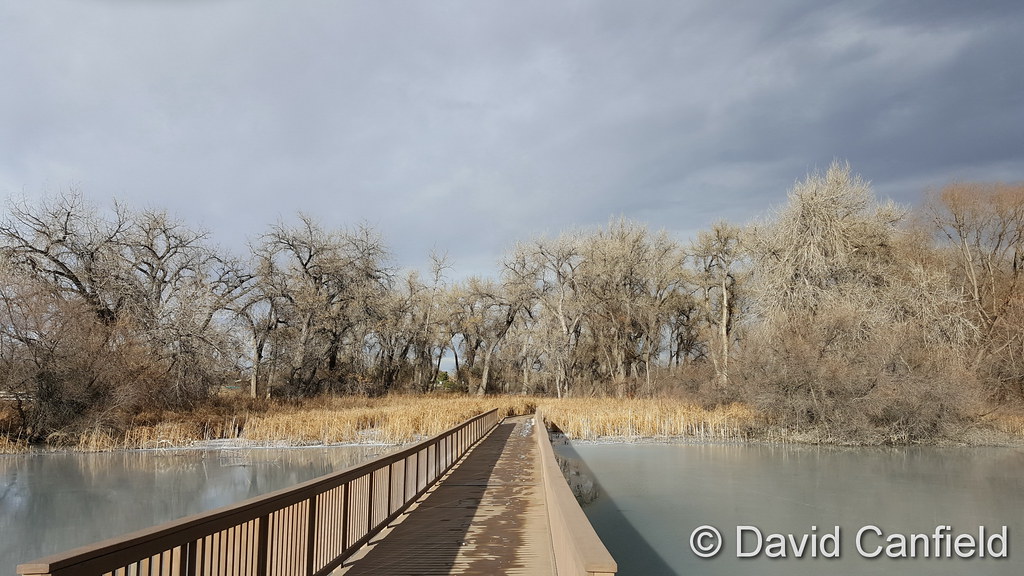
Winter’s light on McKay Lake in Broomfield. (David Canfield)
The month of December can offer everything from bone dry conditions to bone chilling cold and monstrous snowstorms. The weather and wildlife all afford an abundance of photo opportunities as our December photo slideshow shows.
Leaves have fallen from trees now and the landscape can sometimes look quite stark. However it only takes a quick shot of snow to change that picture greatly. Throw in gorgeous sunrises and sunsets, plenty of wildlife big and small, kids playing and much more and the month can be quite colorful and eventful.
Slideshow updated December 31, 2016
To learn more about how to send your photo to us for inclusion in the slideshow, see below the slideshow.
Showcasing images captured by ThorntonWeather.com readers as well as some of our own, our monthly slideshow covers the entire gamut of weather-related imagery.
Sunsets, sunrises, wildlife and of course every type of weather condition are vividly depicted in images captured from yours and our cameras.
[flickr_set id=”72157673879579814″]
What is missing in the slideshow above? Your photo!
Our monthly photo slideshow is going to feature images that we have taken but more importantly images that you have captured. The photos can be of anything even remotely weather-related.
Landscapes, current conditions, wildlife, pets, kids. Whimsical, newsy, artsy. Taken at the zoo, some other area attraction, a local park, a national park or your backyard. You name it, we want to see and share it!
Images can be taken in Thornton, Denver or anywhere across the extraordinary Centennial State. We’ll even take some from out of state if we can tie it to Colorado somehow.
We’ll keep the criteria very open to interpretation with just about any image eligible to be shown in our slideshows.
What do you win for having your image in our slideshow? We are just a ‘mom and pop’ outfit and make no money from our site so we really don’t have the means to provide prizes. However you will have our undying gratitude and the satisfaction that your images are shared on the most popular website in Thornton.
To share you images with us and get them included in the slideshow just email them to us or share them with ThorntonWeather.com on any of the various social media outlets. Links are provided below.
December 25 to December 31: This Week in Denver Weather History
Christmas Day is normally a relatively quiet day in terms of the weather as we recently discussed but the week between it and New Year’s can be quite eventful. Among the highlights are a prolonged period of sub-zero temperatures that lasted nearly five days. Just five years ago a blizzard struck the region that snarled holiday travel on the air and the ground.
From the National Weather Service:
20-25
In 1983…an extremely bitter cold spell occurred. The temperature remained below zero for 115 hours in Denver… The longest sub-zero period on record. The mercury dipped to 21 degrees below zero on the 21st…the coldest recorded temperature in over 20 years. The cold was accompanied by winds that plunged chill factors to 50 to 70 degrees below zero. Two people froze to death in Denver; both were found outside dead of exposure. Numerous cases of frostbite were reported. Hundreds of water pipes broke from the intense cold…water mains and natural gas lines also fractured…and electricity consumption reached record levels. Light snow totaling 5.8 inches fell at times…and holiday traffic was delayed at Stapleton International Airport for several hours. Eight daily temperature records were set at the time. The all-time record low maximum temperature for the month of 8 degrees below zero on the 21st still stands today. Other temperature records still standing include record low maximum temperatures of 5 degrees below zero on both the 22nd and 23rd and 4 degrees below zero on the 24th.
24-25
In 1891…heavy snowfall of 7.0 inches in downtown Denver provided a white Christmas. Most of the snow…6.5 inches… Fell on the 24th. Northwest winds were sustained to 30 mph with gusts to 40 mph on the 24th.
In 1894…snow began falling during the evening of the 24th… Ended during the early afternoon of the 25th…and totaled 6.4 inches in downtown Denver. Northwest winds were sustained to 26 mph with gusts to 30 mph on the 24th. The maximum snow depth on the ground was 5 inches. The high temperature was only 18 degrees on the 25th after a low of 8 degrees.
In 1980…strong Chinook winds of 50 to 60 mph occurred in the foothills with a wind gust to 90 mph recorded at Wondervu. West winds gusted to 33 mph at Stapleton International Airport on the 25th.
In 1997…a relatively rare Christmas snowstorm blanketed much of northeastern Colorado. Snowfall in and near the Front Range foothills and south of metro Denver ranged from 5 to 8 inches. Elsewhere…new snow accumulations were generally 1 to 3 inches. Snowfall totaled only 1.5 inches at the site of the former Stapleton International Airport. North winds gusted to 29 mph at Denver International Airport on the 24th.
In 2012…a winter-like weather moved into northeast Colorado on Christmas Eve as an upper level trough and a strong cold front moved through the region. At Denver International Airport…2.5 inches of snow fell from Christmas Eve through Christmas morning. The high temperatures on Christmas Day only reached 16 degrees…which was the coldest day of the month.
25
In 1873…northwest winds were sustained to 36 mph during the morning and to 48 mph in the evening. The Chinook winds warmed the temperature to a high of 53 degrees.
In 1883…gusty very strong winds raked Boulder…causing 11 hundred dollars in damage.
In 1985…Table Mesa in Boulder was buffeted by wind gusts to 68 mph.
In 1993…occasional high winds occurred over portions of the higher foothills west of Boulder and Denver. A wind gust to 87 mph was recorded on squaw mountain…and a gust to 83 mph occurred at Rollinsville. Northwest winds gusted to 35 mph at Stapleton International Airport.
In 2007…a winter storm brought heavy snow to the Front Range of Colorado. The heaviest snow fell near the foothills of Boulder…Douglas and Jefferson counties. The snow caused accidents throughout the Denver metropolitan area. Gusty winds produced snow drifts from 2 to 3.5 feet in depth. Total snowfall for the calendar day in Denver was 7.8 inches…setting a new record for Christmas Day. The measurement was taken at the former Stapleton International Airport; the previous record was 6.2 inches… Set in 1894. Storm totals in the Front Range foothills included: 13.5 inches at Coal Creek Canyon; 12 inches…5 miles east-southeast of Aspen Park; 11 inches; 6 miles southwest of kassler; 10.5 inches at Eldorado Springs. Elsewhere…storm totals ranged from 5 to 10 inches. In the urban corridor storm totals included: 9 inches near Elizabeth; 8 inches in southwest Denver…Highlands Ranch…Marston Reservoir and Wheat Ridge; 7.5 inches in Arvada; 7 inches in Centennial and Lakewood; 6.5 inches in Aurora and 8 miles southeast of Watkins; 6 inches in Boulder…Englewood and Parker. Elsewhere…storm totals ranged from 3 to 5 inches.
25-26
In 1904…after a warm Christmas Fay with a high temperature of 50 degrees…a late day cold front plunged temperatures to a low of 7 degrees…produced northeast winds sustained to 40 mph with gusts to 54 mph…and produced 5.2 inches of snow overnight for a late white Christmas. The maximum temperature on the 26th was only 16 degrees.
In 2014…a winter storm brought a rare Christmas Day snowfall to the Front Range Foothills and Urban Corridor…from the afternoon of the 25th to the evening of the 26th. Storm totals included: 12.5 inches…4 miles west of Boulder; 12 inches…4 miles southwest of Eldorado Springs and 4 miles south of Golden; 11 inches at Genesee; 10 inches near Allenspark…5 miles west of Chatfield Reservoir… 5 miles southwest of Golden and near Tiny Town; 8 inches in Lakewood and Louisville; 7.5 inches in Niwot; 7 inches in Longmont; with 6 inches in Broomfield and Frederick. At Denver International Airport…5.1 inches of snowfall was observed.
25-31
In 1980…temperatures were unusually warm during the week between Christmas and New Year’s. High temperatures for the week ranged from the mid-50’s to the mid-70’s. Four temperature records were set. Record highs occurred on the 26th with 68 degrees…the 27th with 75 degrees…and the 30th with 71 degrees. A record high minimum temperature of 41 degrees occurred on the 27th.
26
In 1877…heavy snow fell during the early morning and totaled nearly 6 inches. Precipitation from melted snow was 0.58 inch. After the snowfall…a number of sleighs were seen on the city streets.
In 1879…after a morning low of 4 degrees below zero… The temperature climbed to a high of 57 degrees in the city.
In 1907…west winds were sustained to 40 mph. The Chinook winds warmed the temperature to a high of 62 degrees.
In 1949…west winds gusted to 50 mph at Stapleton Airport.
In 1998…intense…but localized…downslope high winds developed near Wondervu in the foothills southwest of Boulder. Winds frequently gusted to 100 mph with a highest reported wind gust to 104 mph. West winds gusted to only 43 mph at Denver International Airport.
26-27
In 1954…a major storm dumped heavy snow across metro Denver. Snowfall totaled 8.6 inches at Stapleton Airport. The storm produced the heaviest snowfall of the calendar year and was the only measurable snowfall in December.
In 1987…a snowstorm stalled in northeastern Colorado…giving metro Denver its worst winter storm in 4 years. Total snowfall from the storm ranged from 12 to 18 inches on the east side…1 to 2 feet in Boulder County…and 2 to 3 feet in western and southern parts of metro Denver. The largest reported snowfall was 42 inches at Intercanyon in the foothills southwest of Denver. Snowfall totaled 14.9 inches at Stapleton International Airport. Winds were light on the 26th…but increased as high as 40 mph on the 27th… Creating near-blizzard conditions and forcing complete closure of Stapleton International Airport for about 8 hours. The strong winds whipped drifts to 5 feet high on the east side of town. All interstate highways leading from Denver were closed on the 27th.
26-28
In 1979 a heavy snow storm dumped 6 to 10 inches of snow over the metro area and 15 to 20 inches at Boulder with up to 2 feet in the foothills west of Boulder. Heavy snowfall totaled 6.0 inches at Stapleton International Airport where north winds gusted to 21 mph. Most of the snow… 4.8 inches…fell on the 27th.
27
In 1895…west Chinook winds sustained to 44 mph with gusts to 48 mph warmed the temperature to a high of 52 degrees.
In 1901…an apparent cold front produced sustained north winds to 41 mph with gusts to 48 mph.
In 1957…northwest winds gusting to 52 mph produced some blowing dust across metro Denver.
In 1975…a northwest wind gust to 53 mph was recorded at Stapleton International Airport.
In 1976…a strong pacific cold front moving across metro Denver produced a northwest wind gust to 53 mph at Stapleton International Airport.
In 1990…high winds raked the eastern foothills with a wind gust to 84 mph clocked on Fritz Peak near Rollinsville. The strong northwest winds of 50 to 70 mph whipped newly fallen snow over higher areas into billowy clouds several hundred feet high that could be seen from most locations across metro Denver.
In 1996…another round of high winds developed over portions of the Front Range foothills during the morning hours. Several wind gusts from 70 to 100 mph were reported at Wondervu southwest of Boulder. West-northwest winds gusted to 38 mph at Denver International Airport.
In 2005…a trained weather observer in Georgetown recorded a wind gust to 94 mph. No damage was reported.
In 2007…a winter storm brought heavy snow to portions of the urban corridor and adjacent plains. Storm totals generally ranged from 3 to 7 inches. Locally heavier bands produced up to 10 inches of snow. In the urban corridor…storm totals included: 10 inches…10 miles south-southeast of Buckley AFB and at Castle Pines; 9.5 inches…4 miles south-southeast of Aurora and Kassler; 7.5 inches…2 miles southeast of Highlands Ranch; 7 inches in Aurora and Sedalia; 6.5 inches in Arvada…4 miles east of Denver and Lafayette; 6 inches in Castle Rock and Thornton. A measurement of 5.4 inches was taken at the former Stapleton International Airport. The official total for the month was 20.9 inches; making it the 6th snowiest December on record.
Santa Claus begins his whirlwind trip around the globe tonight to deliver toys to all the good little boys and girls! For more than 50 years the North American Aerospace Defense Command (NORAD) has tracked Kris Kringle on Christmas Eve and helped to ensure he completes his journey safely.
ThorntonWeather.com is pleased to be able to provide live Santa tracking from NORAD right here on our site!
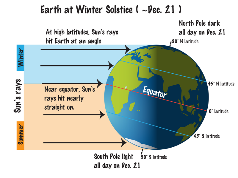
The Earth at the Winter Solstice. The Northern Hemisphere sees their shortest day of the year while the Southern Hemisphere gets its longest. (NASA)
Astronomical winter arrives in Thornton early tomorrow morning and with the solstice also comes the shortest day of the year.
Winter officially begins at 3:44am on Wednesday, December 21, 2016. The Winter Solstice occurs when the North Pole is tilted at its furthest from the sun – 23.5 degrees away. This results in the shortest day of the year in the Northern Hemisphere.
Here in Denver, with sunrise at 7:18am and sunset at 4:39pm, our day Wednesday is 9 hours, 21 minutes and 14 seconds long. The day after it will be three seconds longer and each day from now through to the Summer Solstice in June will get gradually longer as well.
While we have a short day on the winter solstice, it is nothing like what will be experienced in the Arctic Circle. Areas north of there to the North Pole will have no direct sunlight at all. Conversely, areas south of the Antarctic Circle toward the South Pole will have 24 hours of daylight and have a midnight sun.
Did you know that there is a difference between the astronomical seasons that we are discussing here and meteorological seasons?
Meteorological seasons differ slightly and are geared toward matching the calendar with the annual temperature cycle. This is done primarily for meteorological observing and forecasting and in many ways it is more logical than the astronomical seasons.
For the Northern Hemisphere, the meteorological spring covers the months of March, April and May. Summer brings the hottest months of the year and so meteorological summer is June, July and August. Meteorological fall then is September, October and November followed by the coldest months of December, January and February as meteorological winter.
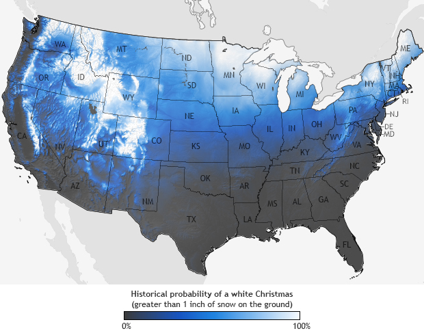
For many, the holiday season isn’t complete without a chill in the air and snow on the ground. Here in Denver we historically enjoy a better chance of experiencing the proverbial white Christmas than many places in the nation.
However, how the Mile High City fares in experiencing a white Christmas does depend on your definition of one.
If it means having actual snowfall on Christmas Day the chances aren’t that good. But, if simply having snow on the ground suffices, the chances improve considerably.
December 18 to December 24: This week in Denver weather history
Looking back at Denver weather history, it is readily apparent that the week leading up to Christmas has historically been a very eventful one. There are certainly many of the snow and wind events we would expect to see. Most notable however are the major winter storms like the pre-Christmas storm of 2006 and of course what is arguably Denver’s most famous winter storm, the Christmas Eve Blizzard of 1982.
In 1924…a prolonged cold spell occurred after mild temperatures during the first half of the month. Most low temperatures dipped below zero with the coldest reading of 15 degrees below zero occurring on the 24th. The high temperature of only 5 degrees on the 18th was a record low maximum for the date.
18
In 1901…north winds were sustained to 52 mph with gusts to 58 mph behind an apparent cold front.
In 1973…a brief blizzard dumped heavy snow across metro Denver. Snowfall totaled 9.2 inches at Stapleton International Airport where north winds gusting to 53 mph produced much blowing snow. The storm forced many schools and businesses to close.
In 1996…a homeless man in Denver was found unconscious in his car suffering from exposure. The man’s body temperature was only 85 degrees when he was discovered. He died several hours later. Early morning temperatures had dipped to 9 degrees below zero.
In 1999…high winds were reported for a brief time in the foothills. Winds gusted to 72 mph in Golden Gate Canyon and to 71 mph at the National Center for Atmospheric Research in the foothills southwest of Boulder. West winds gusted to only 39 mph at Denver International Airport where the temperature warmed to a high of 53 degrees.
In 2002…only a trace of snow fell at the site of the former Stapleton International Airport. This…along with the trace of snow on the 5th…was the only snow of the month…ranking the month the 2nd least snowiest on record.
18-19 In 2012…a storm system brought moderate to heavy snow to the mountains and foothills west of metropolitan Denver and blizzard conditions to plains east of Denver metro area. The combination of snow and wind reportedly reduced visibility to just a few hundred feet at times…and resulted in several road closures including Interstate 70 east of Aurora. East of Denver gusty northerly winds ranged from 35 to 55 mph produced extensive blowing and drifting snow…ranging from 1 to 4 feet in depth. Storm totals ranged from 3 to 5 inches. In the mountain and foothills…the heaviest snowfall occurred along and north of I-70 and included: 12 inches at Genesee…9 inches near Eldorado Springs; 8.5 inches at Coal Creek Canyon…8 inches near Evergreen… with 6 inches at Eldora Ski Area…Idaho Springs… Gross Reservoir and Nederland. At Denver International Airport…1.7 inches of snowfall was observed. In addition…a peak wind gust to 35 mph was observed from the north on the 19th.
18-21
In 2010…a winter storm produced a 4-day period of moderate to heavy snow in the mountains. The combination of strong wind and heavy snow forced the closure of several mountain passes due to the threat of avalanches. The Amtrak train route… Which runs from Denver to California…was rerouted through Wyoming when Union Pacific closed its tracks along Interstate 70. Numerous accidents forced the closure of I-70 at times. The wind gusted to 60 mph over the higher mountain passes. Storm totals in the ski areas west of Denver ranged from 16 to 32 inches.
18-24
In 1998…a vigorous cold front with north winds gusting as high as 38 mph at Denver International Airport on the 18th dropped temperatures from a high of 51 degrees to a low of just 6 degrees before midnight. The arctic air mass that settled over metro Denver produced intermittent light snow and a week-long protracted cold spell that caused low temperatures to plunge well below zero for 6 consecutive nights. The coldest temperature was 19 degrees below zero on the morning of the 22nd. High temperatures climbed only into the single digits on 4 consecutive days…from the 19th through the 22nd. At least 15 people…mostly homeless… Were treated for hypothermia at area hospitals. The bitter cold weather was responsible…either directly or indirectly… For at least 5 fatalities. Three of the victims died directly from exposure. The cold weather also caused intermittent power outages. Following the cold snap… Thawing water pipes cracked and burst in several homes and businesses…causing extensive damage. Only one temperature record was set. The high temperature of only 7 degrees on the 19th set a record low maximum for the date.
19
In 1913…post-frontal heavy snowfall totaled 8.5 inches over downtown Denver. North winds were sustained to only 16 mph.
In 1994…an intense pacific storm system and associated cold front moved across Colorado early in the day. Strong downslope winds buffeted the Front Range eastern foothills. The highest wind gust recorded was 92 mph at Rocky Flats in northern Jefferson County. Most of the wind gusts during the day ranged from 63 to 86 mph with lighter gusts of 40 to 58 mph on the northeast plains. The strong winds downed power lines and poles in south Lakewood…causing power outages to 2400 homes. Other small power outages and surges occurred across metro Denver. Northwest winds gusted to 43 mph at Stapleton International Airport.
19-20
In 1982…high winds buffeted the eastern foothills. At midday on the 19th…gusts of 75 to 80 mph were recorded in the Table Mesa area of Boulder. A gust to 62 mph was clocked in Boulder on the evening of the 20th.
In 1989…strong winds howled at mountain top level in clear creek and Gilpin counties. Speeds reached 97 mph on the summit of Squaw Mountain and 84 mph one mile south of Rollinsville. Northwest winds gusted 35 mph at Stapleton International Airport on the 20th.
19-23
In 1990…a surge of very cold arctic air invaded metro Denver. Many temperature records were broken as the mercury remained at or below zero for 85.5 hours at Stapleton International Airport…making it the third longest period of subzero readings in 118 years of record keeping. On the morning of the 22nd…the mercury plunged to 25 degrees below zero…which equaled the all time record low temperature for the month set on December 24…1876. In the foothills southwest of Denver at tiny town…the mercury plunged to 33 degrees below zero on the morning of the 21st. On the same morning at Castle Rock the temperature dipped to 26 degrees below zero. During the period…other daily temperature records were set at Denver…including: record low maximum of 3 degrees below zero on the 20th and a record low of 17 degrees below zero on the 23rd. The record low was equaled with 16 degrees below zero on the 20th and 21 degrees below zero on the 21st. Snowfall totaled 2.7 inches at Stapleton International Airport from the 19th through the 21st.
20
In 1894…southwest winds were sustained to 40 mph with gusts to 48 mph. The Chinook winds warmed the temperature to a maximum of 69 degrees…which was a record high temperature for the date. The minimum temperature dipped to only 33 degrees.
In 1903…northwest Chinook winds sustained to 54 mph with gusts to 60 mph warmed the temperature to a high of 58 degrees.
In 1948…strong winds occurred along the eastern foothills from Boulder north. Wind gusts to 45 mph were recorded at Valmont with a gust to 30 mph at Boulder airport. Some damage occurred. Wind gusts to 50 mph caused some blowing dust at Stapleton Airport.
In 1957…strong Chinook winds…gusting to 51 mph from the northwest…warmed the afternoon temperature to a high of 54 degrees.
In 1981 high winds were reported in the foothills with a peak gust of 87 mph recorded at Wondervu.
In 1992…strong Chinook winds raked the eastern foothills with 69 mph recorded at Table Mesa in south Boulder. Southwest winds gusted to only 21 mph at Stapleton International Airport.
In 1996…five construction workers were injured…two seriously…when a sudden wind gust blew over a 30-foot- high retaining wall they were working on in western Lakewood. The scaffolding they were standing on collapsed…and some were pinned under the rubble for 15 minutes. Wind gusts of 60 to 75 mph were reported in the area. Southwest winds gusted to only 24 mph at Denver International Airport.
In 2004…strong downslope winds developed over the eastern mountain slopes and spread over metro Denver. Peak wind gusts approached 100 mph along the foothills of Boulder County. In Superior…a 1200-square-foot section of roof was peeled off the gymnasium at Monarch High School. Two semi-trailers were toppled on Colorado highway 58 at McIntyre Street and another at c-470 and west Bowles Avenue. Two airplanes were damaged by wind-blown debris at Jefferson County Airport. The high winds forced the closure of State Highway 93 between Golden and Boulder for approximately two hours. Insurance agents estimated 650 to 850 homes suffered wind damage in the Boulder and Louisville areas. In addition…downed trees and power lines left about 1000 residents…mainly in the Boulder area…without electricity. At least three people suffered minor injuries in the storm. Peak wind reports included: 95 mph in Superior…92 mph at Jefferson County Airport…85 mph in Golden…81 mph in Boulder…80 mph in Broomfield and Evergreen…and 79 mph in Louisville. West northwest winds gusted to 59 mph at Denver International Airport.
20-21
In 1969…high winds caused widespread…but mostly minor damage to roofs…windows…and power lines and overturned some house trailers in areas along and just east of the foothills. Wind gusts of 60 to 70 mph were reported in Boulder and south of Boulder at Rocky Flats. A wind gust to 115 mph was measured in Boulder at the National Center for Atmospheric Research. At Stapleton International Airport…west winds gusted to 44 mph on the 20th and to 45 mph on the 21st. The warm Chinook winds warmed the high temperature to 56 degrees on the 20th and to 65 degrees on the 21st.
In 2006…a major blizzard buried greater metro Denver and the adjacent foothills in deep snow. A slow moving upper level low pressure center produced deep moist upslope flow over the high plains and against the eastern slopes of the mountains…allowing heavy snowfall to persist for 34 hours across metro Denver. Total snow accumulations ranged from 1 to 2 1/2 feet across the city and from 2 to nearly 4 feet in the foothills. Adding to the misery… Strong north winds sustained at 20 to 35 mph with gusts from 45 to nearly 60 mph produced much blowing snow and piled the snow into drifts from 6 to 12 feet high…closing businesses and bringing all transportation to a halt. The storm forced the closure of Denver International Airport for a total of 45 hours which snarled the nation’s air traffic system. This was the longest closure in the airport’s 12 year history. The closure stranded nearly 5000 travelers when 2000 flights were canceled. Many inbound flights were diverted to other airports…stranding even more passengers. Many of the stranded travelers failed to reach their final destinations until days after the airport re-opened due to fully booked flights during the holiday season. Police and national guardsmen rescued hundreds of commuters stuck in their cars…and sent them to temporary shelters set up by the Red Cross. All interstates and other major highways in and out of Denver were closed. Greyhound was forced to cancel all bus trips from Denver. Mail delivery was suspended. The Regional Transportation District suspended all metro Denver bus service for the first time since the March 2003 blizzard. The roof of a discount store in Aurora collapsed under the weight of the heavy snow. In Lakewood…a power outage left 5600 residents without electricity for a brief time. Metro Denver snowfall amounts included: 34 inches 10 miles southeast of Buckley AFB…32 inches in Littleton…30 inches in Thornton and near Castle Rock…29.5 inches near Parker…28 inches in Wheat Ridge…25.5 inches at centennial airport…25 inches at Niwot…24 inches in Aurora…22.5 inches at Greenwood Village… 22 inches in Arvada…21.5 inches in Lakewood…20 inches in Longmont…and 15.5 inches in Boulder. Snowfall measured 20.7 inches officially in the Denver Stapleton area. This ranked the snowfall as the 7th greatest in the city since 1946. North winds were sustained to 37 mph with gusts to 55 mph at Denver International Airport. In the foothills snowfall totaled: 42 inches at Conifer and 11 miles southwest of Boulder…40 inches at Evergreen…39 inches at Aspen Springs… 37.5 inches 8 miles north of Blackhawk…33 inches near Nederland…31 inches at Intercanyon and near Tiny Town…30.5 inches atop Buckhorn Mountain…30 inches near Indian Hills… 29 inches at Rollinsville…24 inches near Gross Reservoir and Ralston Reservoir…22.4 inches atop Crow Hill…and 20 inches near Georgetown. Snowpacked and rutted streets and parking lots persisted for a month or more after the storm and subsequent storms. The heavy snowfall created a snow removal controversy when many citizens complained that residential streets were not cleared in a timely manner in the city and in some suburban areas. This was in spite of the fact that tens of millions of dollars were spent on snow removal. In the city of Denver…snow cover of an inch or more from this storm and subsequent storms persisted for 61 consecutive days…through February 19…2007. This is the second longest period of snow cover on record in the city. Many homeowners who had extensive Christmas lights and decorations in their yards were not able to remove the lights because the wires were buried in deep snow and ice until the end of February or later.
We knew it was going to be cold today in the wake of our overnight snow and sure enough, the numbers bear that out.
Denver recorded a low temperature of 15 degrees below zero at 7:14pm. This easily bests the record low for December 17 of 13 degrees below zero set in 1909.
Here in Thornton, we managed to stay warmer, although with these extremes, that isn’t saying much. Thornton hit a low of 10.7 degrees below zero at 5:57pm.
The storm system brought 5.8 inches of snow to Thornton, our biggest snowfall of the season. Out at DIA where Denver’s official measurements are kept, 8.0 inches fell.
Stay up to date with Thornton’s weather: Be sure to ‘like’ us on Facebook, follow us on Twitter and add us to your Google+ circles.
Weather Geek Stuff is a great place to shop for gifts for weather enthusiasts, weather geeks and weather lovers.
Not everyone gets excited about blizzards, tornadoes, hurricanes and other types of extreme weather but many folks out there are passionate about Mother Nature. Weather enthusiasts are certainly a different breed and they would welcome a gift that shows their enthusiasm for everything the weather offers. Weather Geek Stuff is an online shop just for those whose hearts race with the thrill of severe weather.
Weather Geek Stuff is an online store that provides a host of clothing items and novelties just for weather buffs. From the store’s custom ‘Weather Geek’ and ‘Weather Diva’ logoed merchandise to items imprinted with amusing weather warnings signs as well as Skywarn storm spotter logos, there is something there sure to please any weather lover.
Weather Geek Stuff’s merchandise was shown on the Weather Channel as a recommended gift so you know the quality is good. Stu Ostro, Weather Channel’s Senior Director of Weather Communications even sports a ‘Weather Geek’ t-shirt on his Twitter profile.
Kids and dogs aren’t left out of the weather fun either. There is a wide variety of clothing items sized just right for the little ones from babies to bigger kids. Canine companions as well can get shirts and bowls emblazoned with a weather-related logo.
The selection goes far beyond clothing too. Water bottles, clocks, mugs, bags and other novelties are part of the store’s offerings. For the tech types, cases for iPhones and iPads are available. Recently added products include laptop skins, clipboards and throw blankets.
Weather Geek Stuff is owned and operated by the same folks that run ThorntonWeather.com. We provide ThorntonWeather.com as a no-cost service to the community and use the minimal amount of money made from Weather Geek Stuff to support the costs of running this website and the associated equipment. So remember, if you have a weather buff on your shopping list, by buying from Weather Geek Stuff you are supporting ThorntonWeather.com! You can also donate directly to fund the site here.
December 11 to December 17: This Week in Denver Weather History
This time of year snow is a common occurrence but in our look back at this week in Denver weather history we are struck by the lack of significant snow events in the history books for the period. What we do see instead are a number of high wind events, many of which caused widespread damage.
From the National Weather Service:
2-17
In 1939…more than 2 weeks of unseasonably warm weather made the month the 3rd warmest on record. Seven daily temperature records were set…including the all time record high temperature for the month of 79 degrees on the 5th. Daytime highs were balmy with 14 days in the 60’s and 70’s. Low temperatures dipped to freezing or below on only 5 days. The period was dry with only a trace of snow on the 12th.
3-15
In 1972…a protracted cold spell held an icy grip on metro Denver when maximum temperatures never reached above freezing for 10 consecutive days from the 3rd through the 12th and minimum temperatures dipped below zero on eleven consecutive days from the 5th through the 15th. Daily low temperature records were set with 15 degrees below zero on the 5th…17 degrees below zero on the 6th… And 18 degrees below zero on the 10th. Daily record low maximum readings were set with 3 degrees on the 6th and 6 degrees on the 9th. The very cold temperatures were caused by 3 to 5 inches of snow cover and a Canadian air mass.
8-12
In 1932…the second longest sub-zero period on record in Denver occurred. The temperature fell below zero shortly after 1:00 pm on the 8th and remained below zero for 92 hours until 9:00 am on the 12th. The lowest temperature recorded during this period was 13 degrees below zero on both the 9th and 11th. That temperature on the 11th was a record low for the date. High temperatures of 4 on the 8th…5 below zero on the 9th…1 below zero on the 10th… And 6 below zero on the 11th were record low maximum temperatures for those dates. Light north winds at 5 to 10 mph were accompanied by occasional light snow…which totaled only 2.2 inches.
9-13
In 1961…cold arctic air produced a protracted cold period. The temperature plunged to 16 degrees below zero on the 10th…establishing a new record for the date and the coldest reading since 25 degrees below zero on February 1… 1951. Low temperatures dipped below zero on 5 consecutive days with 9 degrees below zero on the 9th…16 below on the 10th…10 below on the 11th…and 12 below on both the 12th and 13th. High temperatures reached only 3 degrees on the 10th and 6 degrees on the 11th.
10-11
In 1933…downslope winds produced warm temperatures…resulting in record high minimums of 46 degrees on the 10th and 44 degrees on the 11th. High temperatures of 66 degrees on the 10th and 62 degrees on the 11th were not records. Southwest winds were sustained to 16 mph on the 10th.
In 1939…high temperatures of 70 degrees on the 10th and 74 degrees on the 11th were record maximums for the dates. The low temperatures of 39 degrees on the 10th and 41 degrees on the 11th were not records.
In 1948…high winds in Boulder and Louisville caused 1750 dollars in damage. Wind gusts in excess of 70 mph were reported at Valmont and Boulder airport. Chinook wind gusts to 60 mph briefly reduced the visibility to 1/4 mile in blowing dust at Stapleton Airport.
In 1989…the season’s greatest snowfall to date hit metro Denver with 6 to 12 inches of snow. Flight delays at Stapleton International Airport reached 2 hours. Multiple wrecks snarled traffic on I-25 both north and south of the city. Snowfall totaled 7.0 inches at Stapleton International Airport where north winds gusted to 25 mph on the 10th.
11
In 1938…snowfall totaled 3.7 inches in downtown Denver. North winds were sustained to 21 mph with an extreme velocity to 22 mph.
In 1967…wind gusts to 58 mph in downtown Boulder caused minor damage. Northwest winds gusted to 47 mph at Stapleton International Airport.
In 1980…winds to 60 mph were reported in Boulder. Northwest winds gusted to 23 mph at Stapleton International Airport. The Chinook winds warmed temperatures to a high of 67 degrees.
In 1994…strong gusty winds occurred along the Front Range eastern foothills. A wind gust to 67 mph was recorded in Boulder with a gust to 58 mph measured at Jefferson County Airport near Broomfield. No damage was reported. Northwest winds gusted to 31 mph at Stapleton International Airport.
11-12
In 1903…a sharp cold front on the 11th plunged temperatures from a high of 59 degrees to a low of 15 degrees…produced northeast winds sustained to 42 mph along with gusts as high as 60 mph…and produced 1.3 inches of snow overnight. The high temperature on the 12th was only 25 degrees.
In 1968…strong winds buffeted the eastern foothills and plains and caused light…but widespread property damage. Wind gusts of 50 to 75 mph were reported. West winds gusted to 52 mph at Stapleton International Airport.
11-13
In 1940…5.4 inches of snow fell across downtown Denver. This was the only snowfall of the month. Temperatures were quite cold on the 13th with a high of 6 degrees and a low of 2 degrees below zero.
In 1984…up to 6 inches of new snow fell over metro Denver… Hampering flight operations at Stapleton International Airport where snowfall totaled 3.8 inches and east winds gusted to 25 mph on the 11th.
12
In 1937…a thunderstorm…rare in December…produced 0.09 inch of rain in advance of a cold front.
In 1973…high winds occurred across all of metro Denver with the foothills area being hit the hardest. A wind gust to 120 mph was recorded in Boulder where damage to residences…mobile homes…fences…and buildings totaled 100 thousand dollars. A northwest wind gust to 66 mph occurred at Stapleton International Airport.
In 1988…strong winds were recorded in Boulder. Peak wind gusts reached 70 mph at Table Mesa and 61 mph in east Boulder. West winds gusted to 31 mph at Stapleton International Airport.
12-13
In 1916…snowfall totaled 5.7 inches in downtown Denver. Northeast winds were sustained to 27 mph with gusts to 28 mph on the 12th.
In 1992…an upslope snowstorm whitened metro Denver. While snowfall totaled only 4.1 inches at Stapleton International Airport…7 inches of new snow fell in Morrison…with 12 inches measured in Castle Rock. North winds gusted to 23 mph at Stapleton International Airport on the 13th.
In 1995…strong winds gusting to nearly 100 mph whipped across the foothills west of Denver. The strongest wind gusts included 98 mph atop squaw mountain and 75 mph at the Eldora Ski Area. West-northwest winds gusted to 41 mph at Denver International Airport on the 13th.
12-15
In 1921…downslope Chinook winds produced warm temperatures in the city…which resulted in 4 temperature records. High temperatures of 72 degrees on the 13th and 68 degrees on the 15th were record maximums for the dates. Low temperatures of 47 degrees on both the 12th and 13th were record high minimums for the dates. West winds were sustained to 38 mph on the 12th and to 25 mph on the 13th.
John Glenn, the first U.S. astronaut to orbit the earth, has died at age 95, officials said. Glenn passed away Thursday, more than a week after being admitted to the Ohio State University’s James Cancer Hospital. The John Glenn College of Public Affairs at OSU made the announcement. U.S. President Barack Obama issued a statement saying… Continue reading John Glenn, First US Astronaut to Orbit the Earth, Dies at 95→
Weather, natural disasters & climate news and information.