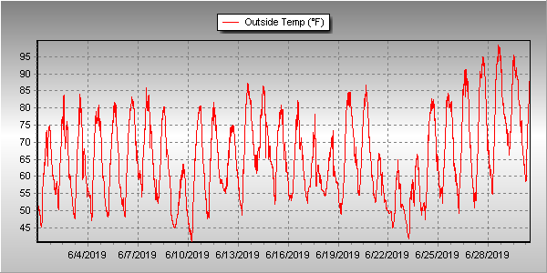
Unsettled would be a good word to sum up Thornton’s weather for June 2019. We experienced a series of troughs and fronts that kept things unsettled and suppressed temperatures. That however did not translate into a great deal of precipitation.
Cooler than normal temperatures were seen across much of the month. Even the later part of June saw some days with high temperatures only in the 60s.
It wasn’t even until the 26th of the month that Denver and Thornton recorded their first 90 degree day of the year. This was in fact the fifth latest occurrence of a 90 degree day in Denver and the latest since 1982.
Thornton’s average temperature for the month came in at 65.7 degrees. This made the month the second coolest June Thornton has recorded in 13 years. Denver saw a virtually identical average of 65.6 degrees. Both readings were below the long term Denver average for June of 67.4 degrees.
Temperatures in Thornton ranged from a high of 98.5 degrees of the 28th of the month down to a low of 40.7 degrees on the morning of the 10th. Denver’s highest reading of 96 degrees came on the 29th and its coolest of 42 degrees on the 10th.
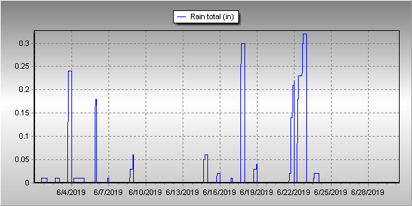
Denver averages 1.98 inches of precipitation during the month of June. This year, Thornton fell short of the mark while Denver exceeded it. Here in Thornton we tallied 1.51 inches while Denver saw 2.24 inches.
Click here to view Thornton’s June 2019 climate report.
CLIMATE REPORT
NATIONAL WEATHER SERVICE DENVER/BOULDER CO
1129 AM MDT MON JUL 1 2019

...................................

...THE DENVER CO CLIMATE SUMMARY FOR THE MONTH OF JUNE 2019...

CLIMATE NORMAL PERIOD 1981 TO 2010
CLIMATE RECORD PERIOD 1872 TO 2019

WEATHER         OBSERVED          NORMAL  DEPART  LAST YEAR`S
                 VALUE   DATE(S)  VALUE   FROM    VALUE  DATE(S)
                                          NORMAL
................................................................
TEMPERATURE (F)
RECORD
 HIGH             105   06/28/2018
                        06/26/2012
                        06/25/2012
 LOW               30   06/02/1951
HIGHEST            96   06/29       104      -8      105  06/28
                        06/28
LOWEST             42   06/10        30      12       44  06/02
                        06/09
AVG. MAXIMUM     80.1              82.4    -2.3     88.8
AVG. MINIMUM     51.2              52.3    -1.1     56.0
MEAN             65.6              67.4    -1.8     72.4
DAYS MAX >= 90      5               7.9    -2.9       16
DAYS MAX <= 32      0               0.0     0.0        0
DAYS MIN <= 32      0               0.0     0.0        0
DAYS MIN <= 0       0               0.0     0.0        0

PRECIPITATION (INCHES)
RECORD
 MAXIMUM         4.96   1882
 MINIMUM            T   1890
TOTALS           2.24              1.98    0.26     0.43
DAILY AVG.       0.07              0.07    0.00     0.01
DAYS >= .01        12               8.4     3.6        5
DAYS >= .10         6               4.6     1.4        2
DAYS >= .50         1               1.4    -0.4        0
DAYS >= 1.00        0               0.3    -0.3        0
GREATEST
 24 HR. TOTAL    0.97   06/18 TO 06/18

SNOWFALL (INCHES)
RECORDS
 TOTAL             MM   MM
TOTALS            0.0               0.0

DEGREE_DAYS
HEATING TOTAL      62                62       0        9
 SINCE 7/1       6281              6058     223     5410
COOLING TOTAL      87               133     -46      241
 SINCE 1/1         92               155     -63      289

FREEZE DATES
RECORD
 EARLIEST     09/08/1962
 LATEST       06/08/2007
EARLIEST      10/10             10/07
LATEST        05/22             05/05
.................................................................

WIND (MPH)
AVERAGE WIND SPEED              9.7
RESULTANT WIND SPEED/DIRECTION   3/182
HIGHEST WIND SPEED/DIRECTION    43/180    DATE  06/02
HIGHEST GUST SPEED/DIRECTION    56/200    DATE  06/02

SKY COVER
POSSIBLE SUNSHINE (PERCENT)   MM
AVERAGE SKY COVER           0.60
NUMBER OF DAYS FAIR            1
NUMBER OF DAYS PC             26
NUMBER OF DAYS CLOUDY          3

AVERAGE RH (PERCENT)     54

WEATHER CONDITIONS. NUMBER OF DAYS WITH
  0
  5
  0
  1
  0
  0
  1
HAZE                      2

-  INDICATES NEGATIVE NUMBERS.
R  INDICATES RECORD WAS SET OR TIED.
MM INDICATES DATA IS MISSING.
T  INDICATES TRACE AMOUNT.


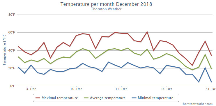
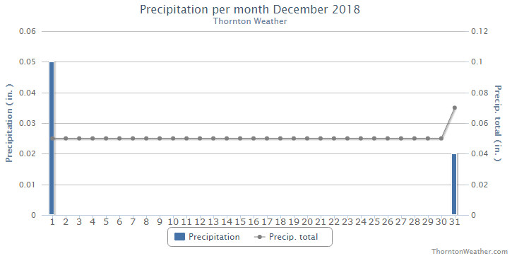
 February in Colorado typically brings to an end an extended period when average temperatures are at their lowest. Winter begins to loosen its grip and temperatures get warmer but precipitation is not a particularly common event during the month.
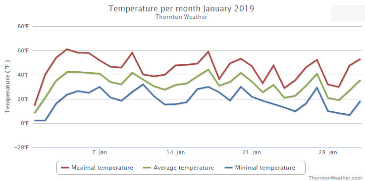
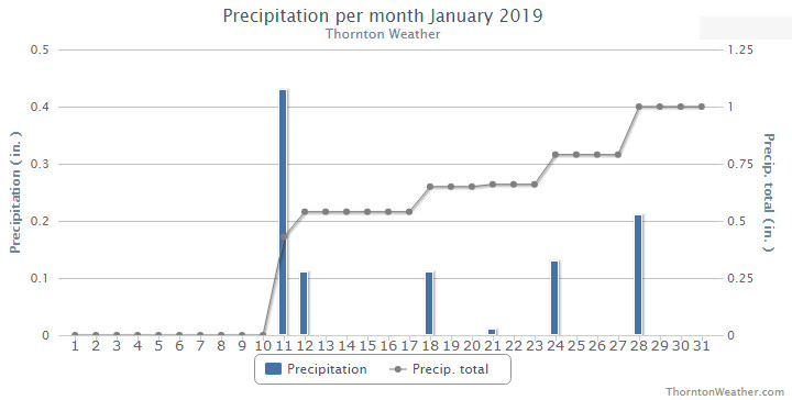
 As we begin the new year the winter chill begins to set in. While January can see its share of extremes, the month historically sees stable temperatures and is usually relatively dry.