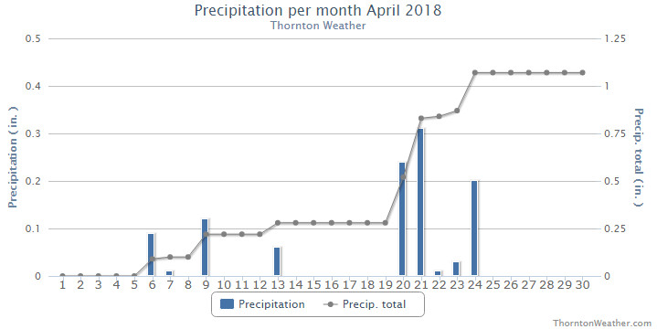
The month of April was one that failed to bring much in the way of snow or rain. This exacerbated the growing drought conditions, despite the end of the month bring some relief.
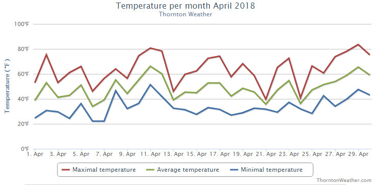
The first third of the month did bring a few days with light snow but nothing that ever amounted to much. Temperatures overall were a bit warmer than normal during the period and many days featured breezy winds serving to help dry things out.
We then put together three unseasonably warm days from the 10th to the 12th. The 13th saw things cool down but the majority of the snow in the region stayed well east of Thornton.
Perhaps the most notable event of the month came on the 17th when a strong upper level system passed over us. This brought extremely strong winds and resulted in Thornton recording its strongest wind gust in the past 10 plus years (62.1 mph).
Finally on the 20th we started seeing some precipitation with two of the next five days seeing light snow and the others having some rain. The month wrapped up with four straight days of temperatures well above normal.
Thornton’s overall average temperature for the month came in at 48.3 degrees. This was nearly a full degree warmer than the long term Denver average temperature for the month of 47.4 degrees. Out at Denver International Airport where the Mile High City’s official measurements are taken, it was slightly cooler with an average reading of 47.8 degres.
Temperatures in Thornton ranged from a high of 83.6 degrees on the 29th down to our coldest reading of 22.1 degrees on the morning of the 6th and the 7th. Denver’s maximum and minimum were similar with 83 degrees on the 29th and 21 degrees on the 6th.
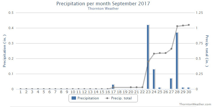
In terms of precipitation, Denver averages 1.71 inches of liquid precip during April Thornton saw only 1.07 inches while Denver was even drier with 0.86 inches.
Snowfall at both locations fell short of the April average of 6.8 inches. Thornton recorded 3.9 inches while Denver only saw 1.5 inches.
Click here to view Thornton’s April 2018 climate report.
CLIMATE REPORT
NATIONAL WEATHER SERVICE DENVER/BOULDER CO
1208 PM MDT WED MAY 2 2018

...................................

...THE DENVER CO CLIMATE SUMMARY FOR THE MONTH OF APRIL 2018...

CLIMATE NORMAL PERIOD 1981 TO 2010
CLIMATE RECORD PERIOD 1872 TO 2018

WEATHER         OBSERVED          NORMAL  DEPART  LAST YEAR`S
                 VALUE   DATE(S)  VALUE   FROM    VALUE  DATE(S)
                                          NORMAL
................................................................
TEMPERATURE (F)
RECORD
 HIGH              90   04/30/1992
 LOW               -2   04/02/1975
HIGHEST            83   04/29                         79  04/14
                                                          04/13
LOWEST             21   04/06                         24  04/10
AVG. MAXIMUM     63.2              61.5     1.7     63.2
AVG. MINIMUM     32.5              33.3    -0.8     34.5
MEAN             47.8              47.4     0.4     48.9
DAYS MAX >= 90      0               0.0     0.0        0
DAYS MAX <= 32      0               0.3    -0.3        1
DAYS MIN <= 32     16              13.0     3.0       15
DAYS MIN <= 0       0               0.0     0.0        0

PRECIPITATION (INCHES)
RECORD
 MAXIMUM         8.24   1900
 MINIMUM         0.03   1963
TOTALS           0.86              1.71   -0.85     0.98
DAILY AVG.       0.03              0.06   -0.03     0.03
DAYS >= .01         8               9.1    -1.1       10
DAYS >= .10         4               4.5    -0.5        5
DAYS >= .50         0               0.9    -0.9        0
DAYS >= 1.00        0               0.5    -0.5        0
GREATEST
 24 HR. TOTAL    0.34   04/21 TO 04/21           04/29 TO 04/29

         OBSERVED                  NORMAL  DEPART  LAST YEAR`S

SNOWFALL  (INCHES)
TOTALS             1.5              6.8

DEGREE_DAYS
HEATING TOTAL     509               529     -20     478
 SINCE 7/1       5250              5731    -481     4803
COOLING TOTAL       2                 1       1        0
SINCE 1/1           2                 1       1        0

FREEZE DATES
RECORD
 EARLIEST     09/08/1962
 LATEST       06/08/2007
EARLIEST                        10/07
LATEST                          05/05
.................................................................

WIND (MPH)
AVERAGE WIND SPEED              12.5
RESULTANT WIND SPEED/DIRECTION    M
HIGHEST WIND SPEED/DIRECTION    46/320    DATE  04/13
HIGHEST GUST SPEED/DIRECTION    70/280    DATE  04/17

SKY COVER
POSSIBLE SUNSHINE (PERCENT)   MM
AVERAGE SKY COVER           0.60
NUMBER OF DAYS FAIR            6
NUMBER OF DAYS PC             17
NUMBER OF DAYS CLOUDY          7

AVERAGE RH (PERCENT)     49

WEATHER CONDITIONS. NUMBER OF DAYS WITH
THUNDERSTORMS             3   MIXED PRECIP           0
HEAVY RAIN                0   RAIN                   2
LIGHT RAIN                9   FREEZING RAIN          0
LT FREEZING RAIN          0   HAIL                   0
HEAVY SNOW                0   SNOW                   2
LIGHT SNOW                8   FOG W/VIS <=1/4 MILE   1
FOG                       8   HAZE                   2

-  INDICATES NEGATIVE NUMBERS.
R  INDICATES RECORD WAS SET OR TIED.
MM INDICATES DATA IS MISSING.
T  INDICATES TRACE AMOUNT.
 February in Colorado typically brings to an end an extended period when average temperatures are at their lowest. Winter begins to loosen its grip and temperatures get warmer but precipitation is not a particularly common event during the month.
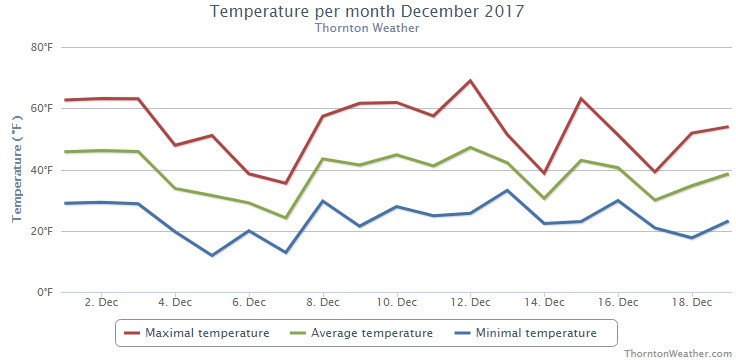
 As we begin the new year the winter chill begins to set in. While January can see its share of extremes, the month historically sees stable temperatures and is usually relatively dry.
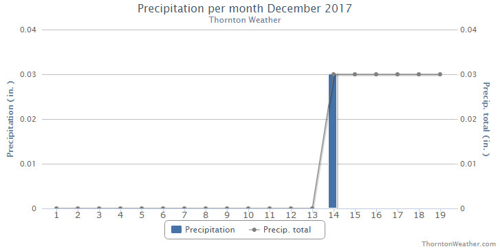
 November proved to be an extraordinarily warm and dry month. Does December have hope for relief?
 The weather during the month of November in Denver metro area can offer just about anything. While it is normally a quiet month, it can be prone to extremes.
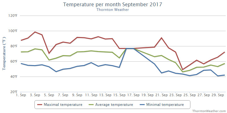
 With the first full month of fall here, October usually brings one of the quietest weather months in the Denver area with plenty of mild, sunny days and clear, cool nights.