With the first full month of fall here, October usually brings one of the quietest weather months in the Denver area with plenty of mild, sunny days and clear, cool nights.
October is historically the second sunniest month and conditions are generally calm.
However we also will usually see our first taste of winter during the month with the first freeze and first snowfall of the season. Temperatures as well will start to drop and by the end of the month the average nighttime lows are below freezing.
Don’t miss a thing when it comes to our ever-changing weather! Be sure to ‘like’ us on Facebook, follow us on Twitter and add us to your Google+ circles.
Thornton’s September this year was relatively benign and lacking much drama although it was a bit of a rollercoaster. Temperatures had their large swings and we saw a couple of days with healthy precipitation.
The month started out slightly cooler than normal on the first but then warmed over the next couple of days to a high of 93.8 degrees on the third.
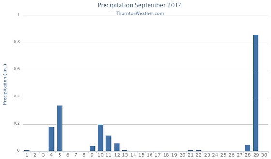
Low pressure and a cold front brought an end to the heat and three days of cooler than normal temperatures arrived. Two of those three days combined to deliver more than a half inch of precipitation.
Warmer and drier weather returned for a few days before a more potent cold front pushed in. The 11th and 12th of the month brought our coldest days of the month. Low temperatures became quite chilly dropping to below freezing on the morning of the 13th as the system moved out.
Some rain fell on those days and while Denver recorded a trace of snow on the morning of the 12th, none was seen in Thornton.
We then rebounded nicely with 10 of the next 11 days seeing high temperatures above 80 degrees, many of those in the mid to upper 80s.
Things cooled down for the last three days as a strong system moved through. We recorded a significant 0.86 inches of rain on the 29th.
Thornton’s overall average temperature for the month was 62.6 degrees. This was a bit below the long term Denver average of 63.4 degrees. Out at the airport, it was as usual warmer with an average of 64.8 degrees.
Temperatures ranged from a high of 93.8 degrees on the 3rd down to a chilly low of 30.9 degrees on the 13th. Denver’s warmest day matched ours on the 3rd with a reading of 94 degrees while the Mile High City’s coldest reading of 33 degrees came on the 12th.
Denver saw one temperature record during the month. The record high minimum for September 25th was set with a reading of 56 degrees. This tied the record for the date last set in 1981.
In terms of precipitation, Thornton recorded 1.89 inches in the rain bucket for the month. Denver saw 1.79 inches. Both were well above Denver’s September average of 0.96 inches.
A daily rainfall record for Denver was set on the 29th when 1.01 inches fell at the airport. The old record of 0.96 inch for the date was set in 1959.
Thornton, Colorado’s September 2014 Temperature Summary. (ThorntonWeather.com)Thornton, Colorado’s September 2014 Precipitation Summary. (ThorntonWeather.com)
...THE DENVER CO CLIMATE SUMMARY FOR THE MONTH OF SEPTEMBER 2014...

CLIMATE NORMAL PERIOD 1981 TO 2010
CLIMATE RECORD PERIOD 1872 TO 2014

WEATHER         OBSERVED          NORMAL  DEPART  LAST YEAR`S
                 VALUE   DATE(S)  VALUE   FROM    VALUE  DATE(S)
                                          NORMAL
................................................................
TEMPERATURE (F)
RECORD
 HIGH              97   09/06/2013
                        09/05/2013
                        09/04/1995
 LOW               17   09/29/1985
HIGHEST            94   09/03        91       3       97  09/06
                                                          09/05
LOWEST             33   09/12        35      -2       38  09/28
AVG. MAXIMUM     78.9              78.5     0.4     78.6
AVG. MINIMUM     50.6              48.3     2.3     54.2
MEAN             64.8              63.4     1.4     66.4
DAYS MAX >= 90      2               3.4    -1.4        7
DAYS MAX <= 32      0               0.0     0.0        0
DAYS MIN <= 32      0               0.8    -0.8        0
DAYS MIN <= 0       0               0.0     0.0        0
PRECIPITATION (INCHES)
RECORD
  MAXIMUM         5.61   2013
  MINIMUM            T   1892                         1944
TOTALS           1.79              0.96    0.83     5.61
DAILY AVG.       0.06              0.03    0.03     0.19
DAYS >= .01         9               6.5     2.5       10
DAYS >= .10         4               3.3     0.7       10
DAYS >= .50         1               0.6     0.4        3
DAYS >= 1.00        1               0.1     0.9        2
GREATEST
 24 HR. TOTAL    1.01   09/29 TO 09/29           09/14 TO 09/15

SNOWFALL (INCHES)
RECORDS
 TOTAL             17.2   1991
TOTALS              T               1.3     -1.3       0

DEGREE_DAYS
HEATING TOTAL      91               125     -34       83
 SINCE 7/1         98               141     -43       83
COOLING TOTAL      88                76      12      133
 SINCE 1/1        701               764     -63      999

FREEZE DATES
RECORD
 EARLIEST     09/08/1962
 LATEST       06/08/2007
EARLIEST                        10/07
LATEST                          05/05
.....................................................

WIND (MPH)
AVERAGE WIND SPEED              9.4
RESULTANT WIND SPEED/DIRECTION   3/186
HIGHEST WIND SPEED/DIRECTION    33/350    DATE  09/09
HIGHEST GUST SPEED/DIRECTION    40/360    DATE  09/09

SKY COVER
POSSIBLE SUNSHINE (PERCENT)   MM
AVERAGE SKY COVER           0.50
NUMBER OF DAYS FAIR           13
NUMBER OF DAYS PC             11
NUMBER OF DAYS CLOUDY          6

AVERAGE RH (PERCENT)     55

WEATHER CONDITIONS. NUMBER OF DAYS WITH
THUNDERSTORM              3     MIXED PRECIP               0
HEAVY RAIN                1     RAIN                       6
LIGHT RAIN                9     FREEZING RAIN              0
LT FREEZING RAIN          0     HAIL                       0
HEAVY SNOW                0     SNOW                       0
LIGHT SNOW                2     SLEET                      0
FOG                       9     FOG W/VIS <= 1/4 MILE      1
HAZE                      3

-  INDICATES NEGATIVE NUMBERS.
R  INDICATES RECORD WAS SET OR TIED.
MM INDICATES DATA IS MISSING.
T  INDICATES TRACE AMOUNT.
September snow in Denver? Possible and not at all unusual.
With a significant blast of cold air set to arrive this week, there is a chance for the Mile High City to see its first snowfall of the season. While such an event would be the first September snow of this millennium, it would hardly be unusual.
Looking back at Denver’s snowfall records dating to 1882, 45 Septembers have recorded a trace or more of snowfall. That means that out of 132 Septembers including this one, roughly one third of them have seen snow. Overall, the month averages 1.1 inches.
Of those 45 Septembers with snow, 17 were for only a trace. Twenty eight, or roughly 21 percent, had measurable snowfall of 0.1” or more.
Denver’s heaviest 24 hour September snowfall came between September 24 and 25 in 1936 when a hefty 15.0 inches fell to the ground. That snowfall contributed to 1936 taking its place as the second snowiest September on record.
For the entire month of September, some years saw rather significant totals. The top 10 September snowfall totals include:
17.2 inches in 1971
16.5 inches in 1936
12.9 inches in 1959
11.4 inches in 1895
8.7 inches in 1985
7.4 inches in 1995
6.5 inches in 1908
5.8 inches in 1961
5.5 inches in 1965
5.4 inches in 1993
The earliest snowfall on record occurred on September 3, 1961. On that date 4 inches of snowfall fell at the old Stapleton International Airport and the mercury dropped to a low of 33 degrees.
The last time Denver saw a September snow was on September 23, 2000 when 0.2 inches was recorded.
On average, we receive our first snow on October 19 so should snow fall, it will be well ahead of normal.
The cold that looks to come could very well bring an end to the growing season. The Mile High City’s first frost on average comes on September 20th followed by the average first freeze on October 7. Given that, a frost at the current time of the month is not that far off the mark. It does not appear at this moment we will see that first freeze – yet – but a frost is possible.
Following on a cooler and wetter than normal August, the month of September arrives and one can’t help but wonder if an early fall lies in wait as well. The month can bring our first snow of the season but more often than not, it is one of the most pleasant along the Colorado Front Range.
As temperatures start to drop, September usually reminds us that summer is at an end and fall is now here. Sunshine is predominant though as the month actually has the highest percentage of sun out of any month. Sunny days and clear, cool nights are the standard weather pattern for the month.
The month can bring extremes however. We will of course forever remember last year’s devastating floods brought on by record-setting rain. Longtime residents might remember September 1971 which brought over 17 inches of snowfall.
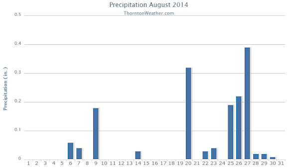
Periods of monsoonal moisture contributed to rain and clouds in August 2014. Coupled with the occasional cold front, the end result was a month that saw temperatures below normal and regular daily thunderstorms.
Thornton’s average temperature for the month came in at 68.2 degrees. This was more than four degrees cooler than Denver’s long term August average of 72.5 degrees. Out at Denver International Airport it was similarly cool with an average reading of 70.6 degrees.
Temperatures in Thornton ranged from a high of 94.4 degrees on the 17th down to a low of 47.6 degrees on the 30th. Only six days saw readings of 90 degrees or higher.
Denver’s warmest reading of 91 degrees occurred on the 17th and again on the 19th. Low readings of 52 degrees were seen on four days during the month. Four 90 degree days were recorded at DIA.
In terms of precipitation, Thornton measured 1.55 inches in the rain bucket over the course of the month. This was slightly below Denver’s August average of 1.69 inches.
The airport however fared better with 2.73 inches as many of the afternoon storms didn’t really get started until they were past Thornton.
Thornton, Colorado’s August 2014 Temperature Summary. (ThorntonWeather.com)Thornton, Colorado’s August 2014 Precipitation Summary. (ThorntonWeather.com)
CLIMATE REPORT
NATIONAL WEATHER SERVICE BOULDER, CO
136 PM MDT MON SEP 1 2014

...................................

...THE DENVER CO CLIMATE SUMMARY FOR THE MONTH OF AUGUST 2014...

CLIMATE NORMAL PERIOD 1981 TO 2010
CLIMATE RECORD PERIOD 1872 TO 2014

WEATHER         OBSERVED          NORMAL  DEPART  LAST YEAR`S
                 VALUE   DATE(S)  VALUE   FROM    VALUE  DATE(S)
                                          NORMAL
................................................................
TEMPERATURE (F)
RECORD
 HIGH             105   08/08/1878
 LOW               40   08/26/1910
                        08/25/1910
                        08/24/1910
                        08/22/1904
HIGHEST            91   08/19       105     -14       99  08/20
                        08/17
LOWEST             52   08/31        40      12       52  08/09
                        08/30
                        08/25
                        08/24
AVG. MAXIMUM     83.8              87.2    -3.4     89.4
AVG. MINIMUM     57.4              57.9    -0.5     59.8
MEAN             70.6              72.5    -1.9     74.6
DAYS MAX >= 90      4              11.5    -7.5       16
DAYS MAX <= 32      0               0.0     0.0        0
DAYS MIN <= 32      0               0.0     0.0        0
DAYS MIN <= 0       0               0.0     0.0        0

PRECIPITATION (INCHES)
RECORD
 MAXIMUM         5.85   1979
 MINIMUM         0.02   1924
TOTALS           2.73              1.69    1.04     2.78
DAILY AVG.       0.09              0.05    0.04     0.09
DAYS >= .01        13               8.6     4.4        7
DAYS >= .10         5               4.3     0.7        2
DAYS >= .50         3               1.2     1.8        2
DAYS >= 1.00        0               0.3    -0.3        1
GREATEST
 24 HR. TOTAL    1.45   08/25 TO 08/26

SNOWFALL (INCHES)
RECORDS
 TOTAL            0.0
TOTALS            0.0               0.0

DEGREE_DAYS
HEATING TOTAL       2                10      -8        0
 SINCE 7/1          7                16      -9        0
COOLING TOTAL     182               244     -62      308
 SINCE 1/1        613               688     -75      866

FREEZE DATES
RECORD
 EARLIEST     09/08/1962
 LATEST       06/08/2007
EARLIEST                        10/07
LATEST                          05/05
..................................................

WIND (MPH)
AVERAGE WIND SPEED              8.9
RESULTANT WIND SPEED/DIRECTION   3/194
HIGHEST WIND SPEED/DIRECTION    48/320    DATE  08/25
HIGHEST GUST SPEED/DIRECTION    48/320    DATE  08/25

SKY COVER
POSSIBLE SUNSHINE (PERCENT)   MM
AVERAGE SKY COVER           0.50
NUMBER OF DAYS FAIR            5
NUMBER OF DAYS PC             24
NUMBER OF DAYS CLOUDY          2

AVERAGE RH (PERCENT)     53

WEATHER CONDITIONS. NUMBER OF DAYS WITH
THUNDERSTORM             14     MIXED PRECIP               0
HEAVY RAIN                5     RAIN                       4
LIGHT RAIN               17     FREEZING RAIN              0
LT FREEZING RAIN          0     HAIL                       1
HEAVY SNOW                0     SNOW                       0
LIGHT SNOW                0     SLEET                      0
FOG                       6     FOG W/VIS <= 1/4 MILE      0
HAZE                      1

-  INDICATES NEGATIVE NUMBERS.
R  INDICATES RECORD WAS SET OR TIED.
MM INDICATES DATA IS MISSING.
T  INDICATES TRACE AMOUNT.
As summer vacations wind down and families prepare to send their kids back to school in August, Colorado weather also starts to settle down. The chances for severe weather decrease markedly during August and by the end of the month daytime temperatures are dropping quite a bit as well. Find out more about what lies ahead with Thornton’s August weather here.
All-in-all, while temperatures and precipitation rain a bit lower than average, June 2014’s weather was pretty close to what we typically expect to see. Thunderstorms made their appearances as always but we were spared much in the way of severe weather.
A series of fronts and troughs moved through northern Colorado during the month. This helped to keep temperatures down and provided thunderstorms with a bit of regularity.
Thornton’s average temperature for the month came in at 66.5 degrees. This is less than one degree below Denver’s historical June average of 67.4 degrees. The Mile High City’s average came in slightly warmer at 67.3 degrees.
Temperatures in Thornton ranged from a high of 92.1 degrees on June 3rd down to a low of 38.2 degrees on the morning of the 9th. Denver was warmer on both measurements with a maximum reading of 94 degrees on the 26th and a low of 42 degrees on the 15th.
Six days saw temperatures top the 90 degree mark in Thornton and Denver. This is below the historical average of 7.9 days of 90 degree or warmer readings we expect to see.
No temperature records were set during the month.
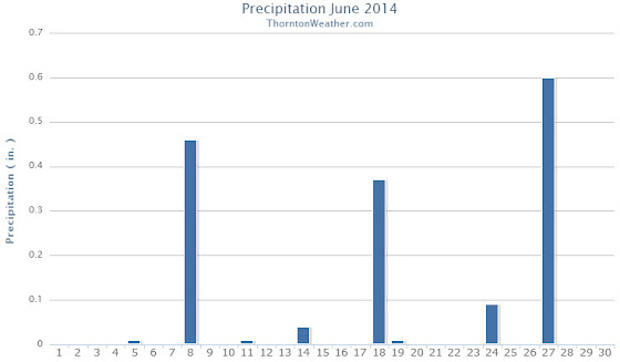
In terms of precipitation, Thornton had 1.59 inches fall into our rain bucket. Denver was a bit wetter with 1.82 inches. Both fell below the June average of 1.98 inches. Thornton saw eight days with measurable precipitation, Denver nine.
Denver set a daily precipitation record of 0.51 inches on the 27th. This bested the old record for that date of 0.29 inches in 1949. Thornton recorded 0.60 inches on the same day.
Thornton, Colorado temperature summary for June 2014.Thornton, Colorado precipitation summary for June 2014.
...THE DENVER CO CLIMATE SUMMARY FOR THE MONTH OF JUNE 2014...

CLIMATE NORMAL PERIOD 1981 TO 2010
CLIMATE RECORD PERIOD 1872 TO 2014

WEATHER         OBSERVED          NORMAL  DEPART  LAST YEAR`S
                 VALUE   DATE(S)  VALUE   FROM    VALUE  DATE(S)
                                          NORMAL
................................................................
TEMPERATURE (F)
RECORD
 HIGH             105   06/26/2012
                        06/25/2012
                        54/01/2206
 LOW               30   06/02/1951
HIGHEST            94   06/26
LOWEST             42   06/15
AVG. MAXIMUM     83.4              82.4     1.0     87.8
AVG. MINIMUM     51.2              52.3    -1.1     54.3
MEAN             67.3              67.4    -0.1     71.1
DAYS MAX >= 90      6               7.9    -1.9       14
DAYS MAX <= 32      0               0.0     0.0        0
DAYS MIN <= 32      0               0.0     0.0        0
DAYS MIN <= 0       0               0.0     0.0        0

PRECIPITATION (INCHES)
RECORD
 MAXIMUM         4.96   1882
 MINIMUM            T   1890
TOTALS           1.82              1.98   -0.16     0.75
DAILY AVG.       0.06              0.07   -0.01     0.03
DAYS >= .01         9               8.4     0.6        4
DAYS >= .10         5               4.6     0.4        2
DAYS >= .50         1               1.4    -0.4        1
DAYS >= 1.00        0               0.3    -0.3        0
GREATEST
 24 HR. TOTAL    0.51   06/27 TO 06/27           06/23 TO 06/23
                        06/26 TO 06/27                    06/22 TO 06/23
                        06/27 TO 06/27                    06/23 TO 06/23
 STORM TOTAL       MM                                 MM
 (MM/DD(HH))            MM                    06/23(00) TO 06/23(00)
                                                 06/23(00) TO 06/23(00)3
                                                 06/23(00) TO 06/23(00)3

SNOWFALL (INCHES)
RECORDS
 TOTAL             MM   MM
TOTALS            0.0               0.0

DEGREE_DAYS
HEATING TOTAL      30                62     -32       29
 SINCE 7/1       6004              6058     -54     6084
COOLING TOTAL     106               133     -27      221
 SINCE 1/1        127               155     -28      263

FREEZE DATES
RECORD
 EARLIEST     09/08/1962
 LATEST       06/08/2007
EARLIEST      10/04             10/07
LATEST        05/14             05/05
....................................................

WIND (MPH)
AVERAGE WIND SPEED              10.5
RESULTANT WIND SPEED/DIRECTION   3/148
HIGHEST WIND SPEED/DIRECTION    39/300    DATE  06/18
HIGHEST GUST SPEED/DIRECTION    55/220    DATE  06/18

SKY COVER
POSSIBLE SUNSHINE (PERCENT)   MM
AVERAGE SKY COVER           0.50
NUMBER OF DAYS FAIR            8
NUMBER OF DAYS PC             21
NUMBER OF DAYS CLOUDY          1

AVERAGE RH (PERCENT)     53

WEATHER CONDITIONS. NUMBER OF DAYS WITH
THUNDERSTORM              0     MIXED PRECIP               0
HEAVY RAIN                3     RAIN                       3
LIGHT RAIN               12     FREEZING RAIN              0
LT FREEZING RAIN          0     HAIL                       3
HEAVY SNOW                0     SNOW                       0
LIGHT SNOW                0     SLEET                      0
FOG                       7     FOG W/VIS <= 1/4 MILE      4
HAZE                      4

-  INDICATES NEGATIVE NUMBERS.
R  INDICATES RECORD WAS SET OR TIED.
MM INDICATES DATA IS MISSING.
T  INDICATES TRACE AMOUNT.
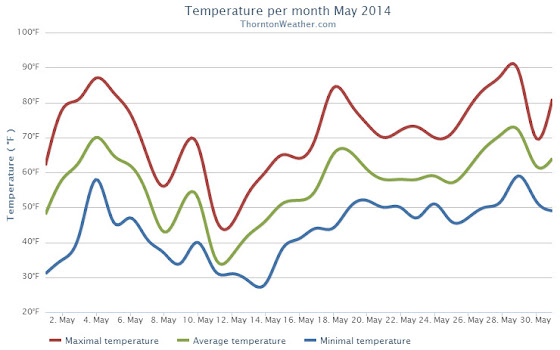
The month of May was a relatively benign, uneventful month in terms of the weather in Thornton. Average temperatures were right on par with normal while precipitation was generous.
We started out the month with warming temperatures and by the third we were seeing highs in the 80s. This only lasted a few days before cooler than normal temperatures settled in for a 10 day period.
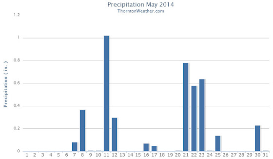
It was during that period that we recorded precipitation for six straight days. This included a good shot of snow on the 11th and 12th.
Temperatures bounced back on the 18th and 19th with highs above 80 degrees but then settled down again to predominantly cooler than normal conditions for the next week. The period from the 20th to the 25th also saw a return to wet conditions.
Warmer and dry conditions returned for a few days and then we closed out the month with cooler temperatures and some more rain.
Thornton finished the month with an average temperature of 56.9 degrees. This was just a hair lower than Denver’s May average of 57.1 degrees. The Mile High City’s average temperature came in warmer at 57.5 degrees.
The hottest temperature recorded occurred on the 29th with a reading of 88.7 degrees. The coldest temperature of 28.5 degrees was on the 14th. Denver’s warmest reading was 85 degrees on the 4th and its coldest of 30 degrees was on the 12th.
In terms of precipitation, Thornton saw a healthy 4.26 inches of liquid precipitation. This was well above the May average of 2.12 inches. Similarly, Denver saw above normal precipitation with a reading of 3.51 inches.
Snow fell on two days and totaled 4.3 inches in Thornton. Out at DIA, only 1.1 inches was recorded. Average snowfall for May in Denver is 1.1 inches.
Click here to view Thornton’s May 2014 climate report.
The Thornton, Colorado temperature summary for May 2014. (ThorntonWeather.com)
The Thornton, Colorado precipitation summary for May 2014. (ThorntonWeather.com)
CLIMATE REPORT
NATIONAL WEATHER SERVICE BOULDER, CO
642 AM MDT SUN JUN 1 2014

...................................

...THE DENVER CO CLIMATE SUMMARY FOR THE MONTH OF MAY 2014...

CLIMATE NORMAL PERIOD 1981 TO 2010
CLIMATE RECORD PERIOD 1872 TO 2014

WEATHER         OBSERVED          NORMAL DEPART LAST YEAR`S
                 VALUE   DATE(S) VALUE   FROM    VALUE DATE(S)
                                          NORMAL
................................................................
TEMPERATURE (F)
RECORD
 HIGH              95   05/26/1942
 LOW               19   05/02/2013
                        05/03/1907
HIGHEST            87   05/28        95      -8       88 05/17
                        05/29
LOWEST             30   05/12        19      11      19 05/02
AVG. MAXIMUM     70.6              71.5    -0.9     71.7
AVG. MINIMUM     44.5              42.7     1.8     44.1
MEAN             57.5              57.1     0.4     57.9
DAYS MAX >= 90      0               0.8    -0.8        0
DAYS MAX <= 32      0               0.0     0.0        0
DAYS MIN <= 32      4               1.9     2.1        4
DAYS MIN <= 0       0               0.0     0.0        0

PRECIPITATION (INCHES)
RECORD
 MAXIMUM         8.57   1876
 MINIMUM         0.06   1974
TOTALS           3.51              2.12    1.39     0.82
DAILY AVG.       0.11              0.07    0.04     0.03
DAYS >= .01        13               9.4     3.6        7
DAYS >= .10         6               4.8     1.2        3
DAYS >= .50         3               1.2     1.8        0
DAYS >= 1.00        1               0.2     0.8        0
GREATEST
 24 HR. TOTAL    1.39   05/20 TO 05/21              0.33 05/07 TO 05/08

SNOWFALL (INCHES)
TOTALS            1.1               1.1              3.4

DEGREE_DAYS
HEATING TOTAL     244               265     -21      253
 SINCE 7/1       5974              5996     -22     6055
COOLING TOTAL      21                21       0       42
 SINCE 1/1         21                22      -1       42

FREEZE DATES
RECORD
 EARLIEST     09/08/1962
 LATEST       06/08/2007
EARLIEST                        10/07
LATEST                          05/05
.........................................................

WIND (MPH)
AVERAGE WIND SPEED              10.6
RESULTANT WIND SPEED/DIRECTION   1/181
HIGHEST WIND SPEED/DIRECTION    37/330    DATE 05/21
HIGHEST GUST SPEED/DIRECTION    42/330    DATE 05/21

SKY COVER
POSSIBLE SUNSHINE (PERCENT)   MM
AVERAGE SKY COVER           0.70
NUMBER OF DAYS FAIR            3
NUMBER OF DAYS PC             18
NUMBER OF DAYS CLOUDY         10

AVERAGE RH (PERCENT)     55

WEATHER CONDITIONS. NUMBER OF DAYS WITH
THUNDERSTORM              0     MIXED PRECIP               0
HEAVY RAIN                2     RAIN                       6
LIGHT RAIN               17     FREEZING RAIN              0
LT FREEZING RAIN          1     HAIL                       1
HEAVY SNOW                0     SNOW                       2
LIGHT SNOW                2     SLEET                      1
FOG                      11     FOG W/VIS <= 1/4 MILE      3
HAZE                      3

- INDICATES NEGATIVE NUMBERS.
R INDICATES RECORD WAS SET OR TIED.
MM INDICATES DATA IS MISSING.
T INDICATES TRACE AMOUNT.
Extreme weather can occur during in month in Colorado we well know. June however is when traditional spring severe weather arrives in the state oftentimes with hail, damaging wind and tornadoes.
Over 40 percent of the tornadoes that occur in Colorado happen during the month of June. Far more common are thunderstorms with hail and wind, each responsible for extensive damage each year.
While severe weather is common, so too are brilliantly sunny and mild days as we close out spring and enter summer. If you are looking for cold, it isn’t likely but it is possible as the Denver area has seen freezing temperatures and yes, even snow, during the month.
Colorado’s famously highly variable weather seems to showcase itself during the month of May when a variety of weather conditions can be seen.
Winter-like temperatures and snow are possible as are mid-summer like temperatures or the more typical spring severe weather.
As the month starts out in 2014 we are going to enjoy a mild period with unseasonably warm temperatures and dry conditions. Long range forecasts predict a relatively ‘normal’ May.
However the month can bring extremes. Snow is not entirely uncommon during the month, oftentimes causing damage to newly bloomed trees. More common however is severe weather, particularly in the latter half of the month. Thunderstorms become more frequent and their associated hazards – lightning, wind, hail and tornadoes – are usual visitors.
 With the first full month of fall here, October usually brings one of the quietest weather months in the Denver area with plenty of mild, sunny days and clear, cool nights.
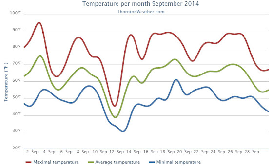
 Following on a cooler and wetter than normal August, the month of September arrives and one can’t help but wonder if an early fall lies in wait as well. The month can bring our first snow of the season but more often than not, it is one of the most pleasant along the Colorado Front Range.


 Extreme weather can occur during in month in Colorado we well know. June however is when traditional spring severe weather arrives in the state oftentimes with hail, damaging wind and tornadoes.