Denver’s recent cold continued as this morning one low temperature record was broken, another tied.
In the wake of our May Day snowstorm, clear skies the following morning allowed temperatures to plummet and reach very winter-like levels. As the mercury bottomed out, Denver broke one low temperature record and tied another.
As measured at Denver International Airport, the temperature this morning dropped to 19 degrees at 6:41am. This easily breaks the previous record low temperature for May 2 of 22 degrees set in 1954.
Most notably, the 19 degree reading also tied the record for the lowest temperature ever recorded during the month of May since record keeping began in Denver in 1872. We have to go all the way back to May 3, 1907 to find a reading that low during May.
Here in Thornton we were quite cold as well although not quite as much as DIA. Our morning low temperature of 20.7 degrees was seen at 6:00am.
The cold and snowy start to May mimics what was seen during the month of April. Last month Denver recorded its fifth coldest and 11th snowiest April on record.
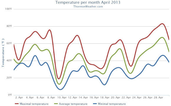
When we look back at April 2013 it will be remembered for two key things: the cold and the snow. By both measurements the month saw extremes with temperatures well below normal and well above normal snowfall, the third month in a row we experienced those conditions.
A series of storm systems moved through during April providing regular doses of cold and snow. Three systems from the 9th of the month through the 25th, each coming at the start of the workweeks, provided the notable conditions. Seventeen of those 18 days saw below normal temperatures.
Denver’s official average temperature for the month came in at 41.7 degrees. This was an impressive 5.7 degrees below the 1981 – 2000 historical average. This put April 2013 into the books as the fifth coldest April since recordkeeping began in Denver. Thornton was only slightly better with an April average temperature of 42.3 degrees.
On four days Denver failed to see high temperatures climb above freezing, Thornton registered three such days.
Five cold temperature records were setting during the month. Record lows were set on April 9th, April 10th and April 22nd. The record low was tied on April 16th. A record low maximum was recorded on the 9th as well.
Temperatures ranged from a high of 80 degrees on the 29th down to a low of 6 degrees on the 10th in Denver. Thornton’s temperatures were similar with a high of 81.7 degrees on the 29th and a low temperature for the month of 6.7 degrees on the 10th.
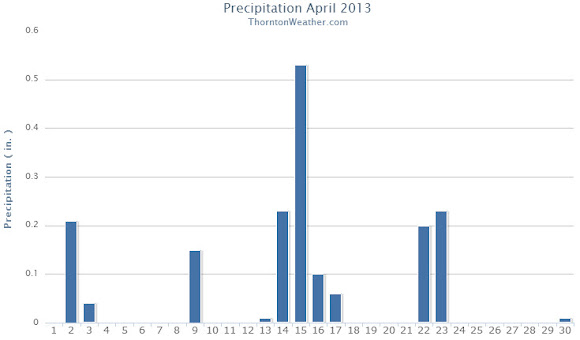
The precipitation was the second half of the April 2013 story with plenty of that falling, primarily in the form of snow.
Denver officially recorded 1.87 inches of liquid precipitation, just a bit above the April average of 1.71 inches. Thornton was just a touch drier with 1.77 inches of precipitation.
Snow was in abundance as Denver saw 20.4 inches of snowfall as measured at Denver International Airport. Thornton was trailing with 19.1 inches. Both marks were well above the Denver April normal of 6.8 inches. Denver’s measurement fell just short of making the list of 10 snowiest Aprils with April 2013 ranking as the 11th snowiest.
Thornton, Colorado April 2013 Temperatures.Thornton, Colorado April 2013 precipitation.
From the National Weather Service:
...THE DENVER CO CLIMATE SUMMARY FOR THE MONTH OF APRIL 2013...

CLIMATE NORMAL PERIOD 1981 TO 2010
CLIMATE RECORD PERIOD 1872 TO 2013

WEATHER         OBSERVED          NORMAL  DEPART  LAST YEAR`S
                 VALUE   DATE(S)  VALUE   FROM    VALUE  DATE(S)
                                          NORMAL
................................................................
TEMPERATURE (F)
RECORD
 HIGH              90   04/30/1992
 LOW               -2   04/02/1975
HIGHEST            80   04/29        83      -3       88  04/24
LOWEST              6   04/10        -2       8       24  04/07
AVG. MAXIMUM     54.7              61.5    -6.8     68.6
AVG. MINIMUM     28.7              33.3    -4.6     37.9
MEAN             41.7              47.4    -5.7     53.3
DAYS MAX >= 90      0               0.0     0.0        0
DAYS MAX <= 32      4               0.3     3.7        0
DAYS MIN <= 32     17              13.0     4.0        4
DAYS MIN <= 0       0               0.0     0.0        0
PRECIPITATION (INCHES)
RECORD
 MAXIMUM         8.24   1900
 MINIMUM         0.03   1963
TOTALS           1.87              1.71    0.16     1.39
DAILY AVG.       0.06              0.06    0.00     0.05
DAYS >= .01        13               9.1     3.9        8
DAYS >= .10         7               4.5     2.5        4
DAYS >= .50         0               0.9    -0.9        0
DAYS >= 1.00        0               0.5    -0.5        0
GREATEST
 24 HR. TOTAL    0.50   04/22 TO 04/23           04/26 TO 04/27

SNOWFALL (INCHES)
RECORDS
 TOTAL           33.8  1933
TOTALS           20.4               6.8

DEGREE_DAYS
HEATING TOTAL     690               529     161      352
 SINCE 7/1       5802              5731      71     5215
COOLING TOTAL       0                 1      -1        6
 SINCE 1/1          0                 1      -1        6

FREEZE DATES
RECORD
 EARLIEST     09/08/1962
 LATEST       06/08/2007
EARLIEST                        10/07
LATEST                          05/05
....................................................

WIND (MPH)
AVERAGE WIND SPEED              11.0
RESULTANT WIND SPEED/DIRECTION   1/016
HIGHEST WIND SPEED/DIRECTION    49/290    DATE  04/14
HIGHEST GUST SPEED/DIRECTION    55/350    DATE  04/08

SKY COVER
POSSIBLE SUNSHINE (PERCENT)   MM
AVERAGE SKY COVER           0.70
NUMBER OF DAYS FAIR            2
NUMBER OF DAYS PC             20
NUMBER OF DAYS CLOUDY          8

AVERAGE RH (PERCENT)     53

WEATHER CONDITIONS. NUMBER OF DAYS WITH
THUNDERSTORM              1     MIXED PRECIP               0
HEAVY RAIN                1     RAIN                       3
LIGHT RAIN               10     FREEZING RAIN              0
LT FREEZING RAIN          0     HAIL                       0
HEAVY SNOW                3     SNOW                       6
LIGHT SNOW                8     SLEET                      0
FOG                      12     FOG W/VIS <= 1/4 MILE      5
HAZE                     11

-  INDICATES NEGATIVE NUMBERS.
R  INDICATES RECORD WAS SET OR TIED.
MM INDICATES DATA IS MISSING.
T  INDICATES TRACE AMOUNT.
Colorado’s famously highly variable weather seems to showcase itself during the month of May when a variety of weather conditions can be seen.
Winter-like temperatures and snow are possible as are mid-summer like temperatures or the more typical spring severe weather.
As the month starts out in 2013 we are going to receive a wintry blast with cold and snow. This is not entirely unusual as Denver averages 1.7 inches of snow during the month since records began.
More common however is severe weather, particularly in the latter half of the month. Thunderstorms become more frequent and their associated hazards – lightning, wind, hail and tornadoes – are usual visitors.
With snowpack lagging and spring set to arrive, hopes were high that March could bring some relief to Colorado’s parched landscape and Mother Nature did oblige. March 2013 brought above average snowfall and cooler than normal temperatures.
The month started out with near normal temperatures but the first in a series of disturbances throughout the month arrived on the 4th. A couple of inches was delivered to the area on the date which was followed by a few days of mild weather.
The warmth did not last as another storm system which began a repeating pattern across the month with mild temperatures followed by periods of cold and snow.
Thornton’s overall average temperature for the month came in at 38.3 degrees. At Denver’s official weather station at Denver International Airport the month averaged 37.7 degrees. Both locations’ average temperatures were below the March historical average (1981 to 2010) of 40.4 degrees.
We recorded 25 days with low temperatures dropping below the freezing mark. Three days saw high temperatures fail to climb above 32 degrees.
Our warmest temperature during March 2013 was a reading of 78.6 degrees on the 15th. The coldest reading was on the 24th when the mercury dropped to a bone-chilling 2 degrees. Out at DIA, the warmest reading was 76 degrees on the 15th and the coldest was 2 degrees on the 25th.
In terms of precipitation, Thornton saw 1.45 inches in the rain bucket, almost all from snow. Denver’s numbers were near identical at 1.47 inches. Both were well above the March average of 0.92 inch.
Snowfall was the big story for the month as Thornton recorded 20.2 inches of the white stuff. Out at DIA the Mile High City saw even more as it measured 23.5 inches. March historically averages 10.7 inches so we were well above normal while the month’s reputation as our snowiest month of the year held true.
The month did come very close to making the list of ‘top 10 snowiest Marches.’ The number 10 spot on that list came in 1981 when 24.0 inches was recorded.
Despite the cold and snow, only one weather record was set during the month. The 11.6 inches of snow recorded at DIA from the 22nd to the 23rd set a two-day snowfall total record for the date, besting the previous mark of 8.0 inches set in 2010.
Thornton, Colorado March 2013 TemperaturesThornton, Colorado March 2013 Precipitation
...THE DENVER CO CLIMATE SUMMARY FOR THE MONTH OF MARCH 2013...

CLIMATE NORMAL PERIOD 1981 TO 2010
CLIMATE RECORD PERIOD 1872 TO 2013

WEATHER         OBSERVED          NORMAL  DEPART  LAST YEAR`S
                 VALUE   DATE(S)  VALUE   FROM    VALUE  DATE(S)
                                          NORMAL
................................................................
TEMPERATURE (F)
RECORD
 HIGH              84   03/26/1971
 LOW              -11   03/28/1886
HIGHEST            76   03/15        84      -8       81  03/31
LOWEST              2   03/25       -11      13       16  03/02
AVG. MAXIMUM     50.7              54.4    -3.7     65.5
AVG. MINIMUM     24.6              26.4    -1.8     32.9
MEAN             37.7              40.4    -2.7     49.2
DAYS MAX >= 90      0               0.0     0.0        0
DAYS MAX = .01         6               5.9     0.1        2
DAYS >= .10         4               2.4     1.6        0
DAYS >= .50         0               0.3    -0.3        0
DAYS >= 1.00        0               0.1    -0.1        0
GREATEST
 24 HR. TOTAL    0.47   03/22 TO 03/22           03/01 TO 03/02
                                                          03/01 TO 03/01
                                                          03/01 TO 03/01
 STORM TOTAL       MM                                 MM
 (MM/DD(HH))            MM                    03/02(00) TO 03/02(00)
                                                 03/01(00) TO 03/01(00)1
                                                 03/01(00) TO 03/01(00)1

SNOWFALL (INCHES)
RECORDS
 TOTAL             MM   5
TOTALS           23.5              10.7

DEGREE_DAYS
HEATING TOTAL     840               763      77      483
 SINCE 7/1       5112              5202     -90     4863
COOLING TOTAL       0                 0       0        0
 SINCE 1/1          0                 0       0        0

FREEZE DATES
RECORD
 EARLIEST     09/08/1962
 LATEST       06/08/2007
EARLIEST      03/01             10/07
LATEST                          05/05
..................................................

WIND (MPH)
AVERAGE WIND SPEED              10.1
RESULTANT WIND SPEED/DIRECTION   1/223
HIGHEST WIND SPEED/DIRECTION    38/010    DATE  03/09
HIGHEST GUST SPEED/DIRECTION    47/280    DATE  03/17

SKY COVER
POSSIBLE SUNSHINE (PERCENT)   MM
AVERAGE SKY COVER           0.60
NUMBER OF DAYS FAIR            2
NUMBER OF DAYS PC             20
NUMBER OF DAYS CLOUDY          9

AVERAGE RH (PERCENT)     53

WEATHER CONDITIONS. NUMBER OF DAYS WITH
THUNDERSTORM              0     MIXED PRECIP               0
HEAVY RAIN                0     RAIN                       0
LIGHT RAIN                1     FREEZING RAIN              0
LT FREEZING RAIN          0     HAIL                       0
HEAVY SNOW                3     SNOW                       5
LIGHT SNOW                8     SLEET                      0
FOG                       9     FOG W/VIS
For four decades Landsat satellites have beamed back amazing pictures of the Earth from their perch far above the planet’s surface. The latest craft in the series was launched last month and among the first images it captured were pictures of the area around Fort Collins and the Galena Fire burn scar.
The Landsat Data Continuity Mission took to space on February 11 to continue the joint program between NASA and the USGS. This latest spacecraft has some of the highest resolution imagery devices of any Earth-observing satellite and will allow the agencies to monitor the natural and human processes taking place on the planet.
This week NASA released some of the first images from the new craft including its ‘Image of the Day’ from the Earth Observatory program on Thursday. The photos capture the northern Colorado Front Range in natural color and one showing wavelengths of light not seen by the human eye. The city of Fort Collins is clearly seen as is the Galena Fire burn scar west of Horsetooth Reservoir.
Below the images are further explanation from NASA.
Made with reflected red, green, and blue light, the image from the Landsat Data Continuity Mission shows Fort Collins as the human eye would see it. (NASA)The image from the Landsat Data Continuity Mission shows the Fort Collins area in wavelengths of light not usually visible to people. Plants are green, city areas are purple, snow is pale blue, and bare earth is tan-pink. . (NASA)
From NASA:
On March 18, 2013, the newly launched Landsat Data Continuity Mission (LDCM) began to send back images of Earth from both of its instruments—the Operational Land Imager (OLI) and the Thermal Infrared Sensor (TIRS). This view of Fort Collins, Colorado, is among the satellite’s first images.
The images above are close-up views from the OLI sensor at its maximum resolution of 15 meters per pixel. The top image displays natural color, while the second image blends shortwave infrared, near-infrared, and green wavelengths (LDCM bands 7, 5, 3). The close-ups were cropped from larger Landsat scenes (downloadable beneath each web image) that show where the Great Plains meet the Front Range of the Rocky Mountains in Wyoming and Colorado.
“The first OLI and TIRS images look great right out of the box,” said Jim Irons, LDCM project scientist. “I have waited a long time to view the first LDCM images and I could not be more impressed with their appearance.”
Made with reflected red, green, and blue light, the top image shows Fort Collins as the human eye would see it. The city is a gray grid surrounded by the curving roads and brown yards of residential neighborhoods. White clouds cast black shadows on the ground below. Land freshly burned in the Galena fire is charcoal black—just slightly darker than the dark green coniferous forest to its west.
The second image shows Fort Collins in wavelengths of light not usually visible to people. Plants are green, city areas are purple, snow is pale blue, and bare earth is tan-pink. This combination of visible and infrared light reveals features of the landscape not otherwise visible. For example, irrigated parks, yards, and golf courses are bright green in this image, but brown in natural color. The Galena Fire burn scar is dark red and easy to distinguish from its surroundings.
The Landsat Data Continuity Mission was launched on February 11, 2013, to continue the four-decade-long Landsat record of Earth’s landscapes. LDCM represents an evolutionary advancement in technology from previous Landsat sensors, collecting more data daily and with greater fidelity. The imagers also include two new bands to improve the view of clouds and near-shore waters.
LDCM’s normal operations are scheduled to begin in late May 2013, after the instruments have been calibrated and the spacecraft has been fully checked out. At that time, NASA will hand over control of the satellite to the U.S. Geological Survey, and the satellite will be renamed Landsat 8.
Spring officially began this morning at 5:02am MDT. It is during this time, the vernal equinox, that the Earth’s axis is not tilted toward or away from the Sun. As a result equal amounts of the Sun’s light are directed to the Northern and Southern Hemispheres.
Soon after the event this morning one of NOAA’s GOES satellites captured the light on the face of the planet in near perfect equilibrium.
At 7:02 ET on March 20, 2013, Earth was at its equinox. At 7:45 ET, the GOES-13 satellite captured this full disk image of Earth. (NOAA) Click the image for a larger view.
From NOAA:
Mar 20, 2013
GOES Satellite Captures Spring Equinox
It is that time of year again (it happens twice) when the relative angle of Earth is perpendicular to the Sun, causing equal incoming solar energy to the Northern and Southern hemispheres – as well as equal day and nighttime. At 7:02 ET on March 20, 2013, Earth was at its equinox. At 7:45 ET, the GOES-13 satellite captured this full disk image of Earth. The visible imagery sensor on GOES requires sunlight to “see” clouds, and so it provides a useful example of the equinox. In this image the GOES imagery extends to each of the poles since the entire hemisphere is equally lit. After the equinox passes today, the Northern Hemisphere will be more lit than the Southern Hemisphere – causing the seasons. (Note: the Sun in this image is artificially created, though the GOES spacecraft does have sensors continually monitoring the Sun for solar activity.)
Northeastern Colorado’s warm, dry winter took a bit of a turn during February as temperatures cooled and we finally received some much needed precipitation.
The month started out with a continuation of the warmer and drier conditions we saw in January. Temperatures for the first days of the month were routinely near or above the 50 degree mark with little precipitation.
That changed on the 9th when low pressure moved through and served to cool things down to below normal. No precipitation was seen however.
The following 10 days were relatively calm and tranquil but with varying temperatures. The month’s high temperature was recorded on the 17th.
As we entered the last part of the month the weather turned much more unsettled and finally delivered a healthy dose of winter. A weak system on the 19th and 20th brought light snow and was followed a few days later by a more significant system on the 24th.
The waning days of the month saw mostly below normal temperatures and one more day of light snow.
The average temperature in Thornton during February 2013 was 30.3 degrees. Out at Denver International Airport, Denver officially had an average of 30.1 degrees. Both were well below the historical February average of 32.5 degrees.
Temperatures in Thornton ranged from a high of 66.2 degrees on the 17th down to the lowest reading of 5.7 degrees on the 25th. Only two days in Thornton failed to climb above freezing.
Denver saw its highest reading of 63 degrees on the 17th and lowest of 5 degrees on the 22nd with six days failing to climb above 32 degrees. All 28 days of the month saw low temperatures below the freezing mark at both locations.
Precipitation was the real weather highlight of February 2013 given how dry the season had been up to then. Thornton recorded 0.71 inches in its bucket while DIA saw 0.77 inches. Average for February is 0.37 so both locations enjoyed above normal measurements.
In terms of snowfall, Thornton measured 11.9 inches of the white stuff. Out at the airport they bested our area with 14.1 inches. Historically February averages a mere 5.9 inches so both were well above normal.
Thornton, Colorado February 2013 TemperaturesThornton, Colorado February 2013 Precipitation
From the National Weather Service:
...THE DENVER CO CLIMATE SUMMARY FOR THE MONTH OF FEBRUARY 2013...

CLIMATE NORMAL PERIOD 1981 TO 2010
CLIMATE RECORD PERIOD 1872 TO 2013

WEATHER         OBSERVED          NORMAL  DEPART  LAST YEAR`S
                 VALUE   DATE(S)  VALUE   FROM    VALUE  DATE(S)
                                          NORMAL
................................................................
TEMPERATURE (F)
RECORD
 HIGH              77   02/28/2006
                        02/04/1890
 LOW              -25   02/01/1951
                        02/08/1936
HIGHEST            63   02/17        70      -7       65  02/25
LOWEST              5   02/22       -14      19        3  02/11
AVG. MAXIMUM     43.3              46.2    -2.9     38.7
AVG. MINIMUM     16.9              18.9    -2.0     18.1
MEAN             30.1              32.5    -2.4     28.4
DAYS MAX >= 90      0               0.0     0.0        0
DAYS MAX = .01         6               5.3     0.7        7
DAYS >= .10         4               0.7     3.3        2
DAYS >= .50         0               0.0     0.0        1
DAYS >= 1.00        0               0.0     0.0        0
GREATEST
 24 HR. TOTAL    0.43   02/24 TO 02/24           02/02 TO 02/03

SNOWFALL (INCHES)
RECORDS
 TOTAL           22.1   1912
TOTALS           14.1               5.7

DEGREE_DAYS
HEATING TOTAL     972               908      64     1055
 SINCE 7/1       4272              4439    -167     4380
COOLING TOTAL       0                 0       0        0
 SINCE 1/1          0                 0       0        0

FREEZE DATES
RECORD
 EARLIEST     09/08/1962
 LATEST       06/08/2007
EARLIEST                        10/07
LATEST                          05/05
....................................................

WIND (MPH)
AVERAGE WIND SPEED              10.3
RESULTANT WIND SPEED/DIRECTION   2/229
HIGHEST WIND SPEED/DIRECTION    35/360    DATE  02/15
HIGHEST GUST SPEED/DIRECTION    44/010    DATE  02/15

SKY COVER
POSSIBLE SUNSHINE (PERCENT)   MM
AVERAGE SKY COVER           0.60
NUMBER OF DAYS FAIR            5
NUMBER OF DAYS PC             16
NUMBER OF DAYS CLOUDY          7

AVERAGE RH (PERCENT)     51

WEATHER CONDITIONS. NUMBER OF DAYS WITH
THUNDERSTORM              0     MIXED PRECIP               0
HEAVY RAIN                0     RAIN                       0
LIGHT RAIN                1     FREEZING RAIN              0
LT FREEZING RAIN          0     HAIL                       0
HEAVY SNOW                1     SNOW                       4
LIGHT SNOW               10     SLEET                      0
FOG                       9     FOG W/VIS
Looking back at January 2013 the numbers reveal a month that wasn’t particularly extraordinary by any measure. Temperatures were slightly below average and precipitation was a bit less than normal.
The first half of the month was notable for cold while the second half for the most part was considerably warmer.
Temperatures for the first three days were well below normal before we entered a brief period with above average temperatures. That was followed by very cold days on the 12th and 13th when high temperatures only reached the teens. Most of the following two weeks were notable for highs in the 50s and 60s.
The month started out extraordinarily dry with a mere 0.3 inch of snow being recorded during the first 27 days. On the 28th though we received a decent little shot of snow to drive up the numbers.
The average temperature for the month came in at 29.7 degrees. This was a full degree below the Denver January average of 30.7 degrees. At the official Denver station at Denver International Airport, the monthly average was slightly warmer at 30.3 degrees.
Temperatures in Thornton ranged from a high of 67.8 degrees on the 24th down to a low of -2.4 degrees on the 15th. Denver recorded a highest temperature of 66 degrees, also on the 24th, and a low of -12 degrees on the 12th.
There were no temperature records set during the month.
In terms of precipitation, an anemic 0.21 inch was measured in Thornton while Denver fared better with 0.31 inch. The January average is 0.41 inch so both locations were a good bit below normal.
Snowfall was similarly light with Thornton recording 3.7 inches, most of which fell during the storm on the 28th and 29th. Out at DIA Denver officially measured 4.6 inches for the month. Average for January is 7.0 inches.
None of the precipitation or snowfall measurements were records.
Thornton, Colorado January 2013 Temperature Summary. (ThorntonWeather.com)Thornton, Colorado January 2013 Precipitation Summary. (ThorntonWeather.com)
From the National Weather Service:
...THE DENVER CLIMATE SUMMARY FOR THE MONTH OF JANUARY 2013...

CLIMATE NORMAL PERIOD 1981 TO 2010
CLIMATE RECORD PERIOD 1872 TO 2013

WEATHER         OBSERVED          NORMAL DEPART LAST YEAR`S
                 VALUE   DATE(S) VALUE   FROM    VALUE DATE(S)
                                          NORMAL
................................................................
TEMPERATURE (F)
RECORD
 HIGH              76   01/27/1888
 LOW              -29   01/09/1875
HIGHEST            66   01/24        76     -10       66 01/21
LOWEST            -12   01/12       -29      17       -6 01/11
AVG. MAXIMUM     44.6              44.0     0.6     50.3
AVG. MINIMUM     16.0              17.4    -1.4     21.6
MEAN             30.3              30.7    -0.4     36.0
DAYS MAX >= 90      0               0.0     0.0        0
DAYS MAX = .01         4               4.1    -0.1        4
DAYS >= .10         1               0.9     0.1        1
DAYS >= .50         0               0.0     0.0        0
DAYS >= 1.00        0               0.0     0.0        0
GREATEST
 24 HR. TOTAL    0.22   01/28 TO 01/29

SNOWFALL (INCHES)
RECORDS
 TOTAL           24.3   1992
TOTALS            4.6               7.0

DEGREE_DAYS
HEATING TOTAL    1067              1063       4      891
 SINCE 7/1       3300              3531    -231     3325
COOLING TOTAL       0                 0       0        0
 SINCE 1/1          0                 0       0        0

FREEZE DATES
RECORD
 EARLIEST     09/08/1962
 LATEST       06/08/2007
EARLIEST                        10/07
LATEST                          05/05
..................................................

WIND (MPH)
AVERAGE WIND SPEED              8.8
RESULTANT WIND SPEED/DIRECTION   4/205
HIGHEST WIND SPEED/DIRECTION    38/290    DATE 01/24
HIGHEST GUST SPEED/DIRECTION    45/290    DATE 01/24

SKY COVER
POSSIBLE SUNSHINE (PERCENT)   MM
AVERAGE SKY COVER           0.50
NUMBER OF DAYS FAIR            8
NUMBER OF DAYS PC             20
NUMBER OF DAYS CLOUDY          3

AVERAGE RH (PERCENT)     48

WEATHER CONDITIONS. NUMBER OF DAYS WITH
THUNDERSTORM              0     MIXED PRECIP               0
HEAVY RAIN                0     RAIN                       0
LIGHT RAIN                1     FREEZING RAIN              0
LT FREEZING RAIN          0     HAIL                       0
HEAVY SNOW                1     SNOW                       1
LIGHT SNOW                5     SLEET                      0
FOG                       7     FOG W/VIS
As we wrap up a January that was pretty much average in terms of temperature and precipitation, we look to February with hope for relief from the dry conditions we have seen thus far this winter. Unfortunately historically February is a relatively dry month but we do start working off winter as temperatures climb.
To date Denver’s seasonal snowfall is 10.8 inches below average and Thornton is even further behind. February though is only the Mile High City’s sixth snowiest month so while we can receive big storms in February, we can’t count on making up much ground.
For those looking forward to milder weather, average temperatures do increase during the month as a sign that winter is fading and spring is approaching.
The 2012 / 2013 snow season has been dismal and while December brought some hope for recovery, recent weeks have seen snowpack decline once again. For the drought and fire weary state of Colorado the data does not bode well.
For the north-central Colorado mountains, the January 22 snowpack is at its second lowest level to date since 1979. Only 1981 saw worse results this far into the season.
According to the latest Colorado SNOTEL reports, the South Platte, North Platte and Upper Colorado River basins are at 57%, 65% and 60% of normal respectively. Statewide Colorado snowpack is a dismal 62% of average.
Is there hope? Mother Nature certainly works on her own schedule so it is possible we could see a recovery. However the latest 3-month outlook from the Climate Prediction Center forecasts warmer and drier than normal temperatures.
North-central Colorado snowpack through January 22. Click the image for a larger view. (NRCS)
Weather, natural disasters & climate news and information.


")
")
")


")
")
 As we wrap up a January that was pretty much average in terms of temperature and precipitation, we look to February with hope for relief from the dry conditions we have seen thus far this winter. Unfortunately historically February is a relatively dry month but we do start working off winter as temperatures climb.
")