The weather during the month of November in Denver metro area can offer just about anything. While it is normally a quiet month, it can be prone to extremes.
November has historically been one of Denver’s snowiest months and major snowstorms are not entirely uncommon. However conditions can also be quite dry.
Temperatures during the month continue to cool as we get closer to winter and by the end of the month the low temperatures routinely dip to 20 degrees or below. At times it can in fact bring conditions more like what we see in January.
With the first full month of fall here, October usually brings one of the quietest weather months in the Denver area with plenty of mild, sunny days and clear, cool nights.
October is historically the second sunniest month and conditions are generally calm.
However we also will usually see our first taste of winter during the month with the first freeze and first snowfall of the season. Temperatures as well will start to drop and by the end of the month the average nighttime lows are below freezing.
September 2023 Temperature Summary for Thornton, Colorado.
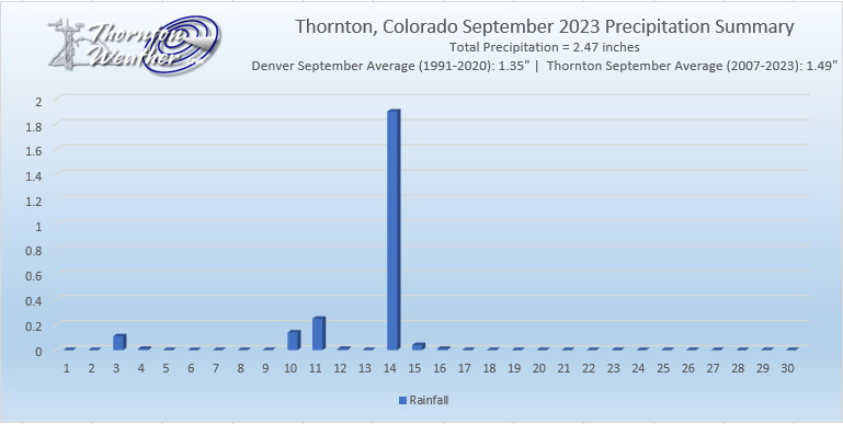
For the third month in a row, September brought above average temperatures and above average precipitation to Thornton. The month was, however, lacking of much drama making for a pretty quiet month.
Thornton’s average temperature for the month came in at 66.2 degrees. That was a good bit above our running 17-year average of 64.0 degrees. Temperatures ranged from a high of 100 degrees on the first down to 43 degrees on the 16th and 25th.
Denver, as measured at Denver International Airport, saw even warmer temperatures. The Mile High City’s average temperature was 68.0 degrees, 3.2 degrees above their September average. It tied Denver’s record for the 8th warmest September on record (since 1872).
In terms of precipitation, Thornton’s September came in at a healthy 2.47 inches. That was nearly an inch above our 17-year running average for the month of 1.49 inches. Much of that, however, came in a single afternoon deluge on the 14th that dumped 1.90 inches of rain.
Denver saw considerably less precipitation (as measured at DIA) with a mere 0.67 inches falling in their bucket. That was well below the Mile High City’s September average of 1.35 inches.
No snowfall was recorded in Thornton or Denver for the month.
Our mild days of late have helped keep the nights relatively warm and last night we saw our warmest night for the date.
As measured at Denver International Airport, the Mile High City saw a low of 58 degrees. This sets a new record high minimum for October 1, besting the previous mark of 57 degrees set in 2005.
Here in Thornton, the breezy winds kept us even warmer with a low of 60.6 degrees.
We have enjoyed much warmer than normal temperatures this past week and today, we were warm enough to set a record high.
As measured at Denver International Airport, the Mile High City topped out at 91 degrees. This bests the previous record high temperature for September 30th of 90 degrees set in 1980. This also is the hottest temperature seen this late in the year since record-keeping began in 1872.
Here in Thornton we were actually a bit cooler with a high of 89.3 degrees.
Following an August that was unseasonably warm, we find ourselves heading into September hoping for relief. The month can bring plenty of rain and even our first snow of the season but more often than not, it is one of the most pleasant along the Colorado Front Range.
As temperatures start to drop, September usually reminds us that summer is at an end and fall is now here. Sunshine is predominant though as the month actually has the highest percentage of sun out of any month. Sunny days and clear, cool nights are the standard weather pattern for the month.
The month can bring extremes however. We will of course forever remember 2013’s devastating floods brought on by record-setting rain. Longtime residents might remember September 1971 which brought over 17 inches of snowfall.
Following on yesterday’s record high temperature, today’s low end did not get particularly cool and, in fact, tied a record.
As measured at Denver International Airport, the Mile High City’s low temperature for September 2 came in at 67 degrees. This tied the record for warmest low temperature for the date last set in 1939.
Here in Thornton, we cooled down to far more normal levels. Our low for the date was 61.7 degrees.
While it may be the first day of meteorological autumn, Mother Nature isn’t giving up on summer yet.
As measured at Denver International Airport, the Mile High City hit a high temperature today of 99 degrees. This breaks the previous record high for the date of 98 degrees set in 2019.
Here in Thornton, we bested Denver by one degree with a high of 100 degrees.
Not only did the heat impact the daytime, it kept things quite warm in the night and morning setting two records for the date.
As measured at Denver International Airport, the Mile High City’s low temperature for August 21 was 72 degrees. This was easily warmer than the previous record high minimum for the date of 67 degrees set in 1946 and previous years.
During the day, Denver saw an official high temperature of 99 degrees. This bested the previous record high temperature for the date of 97 degrees set in 2007 and previous years.
Here in Thornton we experienced similar conditions. Our low temperature dropped to only 70 degrees, much warmer than normal. We also were a touch warmer with a high of 100 degrees for the day.
Mother Nature isn’t giving a lot of relief at night from the daytime heat and as a result Denver set a record.
As measured at Denver International Airport, the Mile High City’s low temperature for today was only 69 degrees. This is a good bit warmer than the previous record high minimum of 67 degrees set in 2020.
Thornton virtually matched that reading with a low of 66.5 degrees.
Weather, natural disasters & climate news and information.
 The weather during the month of November in Denver metro area can offer just about anything. While it is normally a quiet month, it can be prone to extremes.
 With the first full month of fall here, October usually brings one of the quietest weather months in the Denver area with plenty of mild, sunny days and clear, cool nights.

 Following an August that was unseasonably warm, we find ourselves heading into September hoping for relief. The month can bring plenty of rain and even our first snow of the season but more often than not, it is one of the most pleasant along the Colorado Front Range.