Category Archives: Weather Education

June 14 to June 20 – This week in Denver weather history

June 14 to June 20 - This week in Denver weather history

With severe weather season in full swing, we see a very eventful week in Denver weather history.  Wildfires, amazing hail storms, tornadoes, floods and more all make an appearence on the historical calendar.

11-14

In 1999…damage from several hailstorms in and near metro Denver totaled 35 million dollars.  About 17.5 million dollars was from automobile claims with another 17.5 million in homeowner claims.  The areas hardest hit by the storms included Castle Rock…Commerce City…evergreen… And Golden.

12-17

In 2000…two large wildfires developed in the Front Range foothills as careless campers and very dry conditions proved to be a dangerous combination.  Strong winds gusting in excess of 60 mph on the 13th fanned the flames… Spreading both wildfires out of control.  Winds gusted to 78 mph atop Niwot Ridge near the continental divide west of Boulder.  The Hi Meadows Wildfire…about 35 miles southwest of Denver…consumed nearly 11 thousand acres and 80 structures…mostly high priced homes.  The Bobcat Wildfire…located about 12 miles southwest of Fort Collins… Consumed nearly 11 thousand acres and 22 structures.  Late on the 16th…a strong cold front moved south over the great plains into northeastern Colorado.  Low level upslope conditions developed in the wake of the front…producing 2 to 4 inches of snowfall overnight at elevations above 8 thousand feet.  Firefighters were able to contain both fires shortly thereafter.

13-14

In 2006…the high temperature of 99 degrees on the 13th equaled the record maximum temperature for the date first set in 1994.  The high temperature of 102 degrees on the 14th was a new record maximum temperature for the date.

14   

In 1877…an evening thunderstorm produced lightning which struck several houses and killed a cow in the bottom land of the South Platte River
 
In 1886…hail as large as 3/4 inch in diameter fell in the city.  Precipitation was only 0.10 inch.
 
In 1887…south winds were sustained to 41 mph.
 
In 1900…a thunderstorm produced northwest winds to 51 mph with gusts to 61 mph…but only a trace of rain.
 
In 1923…a severe thunderstorm pelted the city with hail. The stones ranged in diameter from 0.2 to 0.8 inch. Gardens and greenhouses suffered considerable damage. Rainfall was only 0.14 inch downtown.
 
In 1960…one workman was killed and 4 others injured in Lakewood when a partly built apartment building collapsed in strong winds.  Microburst wind gusts to 54 mph caused some blowing dust at Stapleton Airport.
 
In 1967…tornadoes touched down briefly 3 miles west of Franktown and 4 miles northeast of Parker.  No damage was reported.  Numerous funnel clouds were reported over south metro Denver…one 5 miles south of Denver…one 2 to 3 miles north of Castle Rock…and two near Littleton.
 
In 1968…a microburst wind gust to 52 mph was recorded at Stapleton International Airport.
 
In 1972…1 3/4 inch hail was reported in Wheat Ridge.
 
In 1976…high winds…unusually strong for this late in the season…raked metro Denver.  Wind gusts estimated to 100 mph tore 24 boats from their moorings and damaged a total of 47 boats at Boulder reservoir.  Wind gusts to 82 mph were recorded in Boulder.  The strong winds toppled the wind mast at a radio station in Boulder.  An automobile was smashed by a fallen tree in Boulder.  Other damage in Boulder was minor…but power outages occurred when tree limbs fell on power lines.  At Jefferson County Airport near Broomfield…wind gusts to 78 mph were recorded with 87 mph gusts clocked at rocky flats nuclear plant south of Boulder.  Wind gusts to 66 mph were observed in Littleton… And northwest winds gusted to 46 mph at Stapleton International Airport.  The strong winds collapsed a barn near Arvada.  Several horses received minor injuries. Thirty trees were uprooted or broken in Denver.  Four major power outages occurred from west Denver and Lakewood to the foothills.
 
In 1982…the worst hailstorm in 17 years struck Commerce City.  The storm left 4 to 8 inches of hail on the ground. A few of the stones were as large as golf balls.  Many vehicles were dented…and some windshields were shattered. Roofs of homes were damaged.   Total damage was estimated at over one million dollars.  Hail to 1 inch in diameter also fell in Littleton.  Only 1/4 inch hail was measured at Stapleton International Airport.
 
In 1988…lightning ripped a small hole in the roof of a home in the southern part of Boulder.  There were some power outages in the area.
 
In 1992…an off duty national weather service employee reported hail to 1 inch diameter in Westminster.
 
In 1997…one inch diameter hail fell in Bennett…and 3/4 inch hail was measured in Littleton.
 
In 1999…hail as large as 1 1/2 inches in diameter hit Aurora. Lightning sparked two small fires at separate residences near the hiwan country club in evergreen.
 
In 2004…lightning sparked two small fires near Jamestown. One was in geer canyon and the other 7.5 miles up sunshine canyon.  Both were quickly contained and caused no damage to structures in the area.

Continue reading June 14 to June 20 – This week in Denver weather history

New Red Cross tornado safety guidelines spark controversy

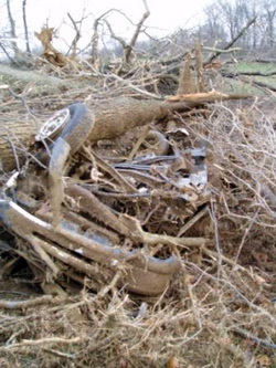
Should you ride out a tornado in your vehicle?  The  Red Cross has issued new guidelines that conflict with those from the National Weather Service.  This photo is of a Ford Ranger pickup truck that was blown one-quarter mile and found underneath tree debris after the March 28, 2009 tornado near Corydon, KY.  (NWS)
Should you ride out a tornado in your vehicle? The Red Cross has issued new guidelines that conflict with those from the National Weather Service. This photo is of a Ford Ranger pickup truck that was blown one-quarter mile and found underneath tree debris after the March 28, 2009 tornado near Corydon, KY. (NWS)

The American Red Cross has updated its tornado safety guidelines, modifying longstanding recommendations putting them in conflict with those provided by NOAA and the National Weather Service. The new guidelines no longer recommend evacuating a car if a tornado is about to strike and finding a low-lying ditch to hide in. Instead, the Red Cross is now recommending remaining in the vehicle.

Until now, all tornado safety guidelines were consistent in saying that remaining in a car during a tornado, just like a mobile home, is one of the worst possible places to be. The vehicle stands a great chance of being picked up and thrown and destroyed with its occupants trapped inside.

The National Weather Service, and the Red Cross until now, believes that lying flat in a ditch provides a greater chance of survival. Your body provides a smaller target for winds and by being in a ditch, debris and winds have a better chance of passing over you.

The new guidelines from the Red Cross say:

  • If you are caught outdoors, seek shelter in a basement, shelter, or sturdy building. If you cannot get to shelter, a recent study* suggests doing the following:
    • Get into a vehicle, buckle your seat belt, and try to drive at right angles to the storm movement and out of the path.
    • If strong winds and flying debris occur while you are driving, pull over and park, keeping seat belts on and the engine running. Put your head down below the windows, covering with your hands and a blanket if possible.

Compare this to the guidelines from the National Weather Service’s Storm Prediction Center:

Vehicles are extremely dangerous in a tornado. If the tornado is visible, far away, and the traffic is light, you may be able to drive out of its path by moving at right angles to the tornado. Otherwise, park the car as quickly and safely as possible — out of the traffic lanes. [It is safer to get the car out of mud later if necessary than to cause a crash.] Get out and seek shelter in a sturdy building. If in the open country, run to low ground away from any cars (which may roll over on you). Lie flat and face-down, protecting the back of your head with your arms.

Researchers for the Red Cross cited studies from historical tornado damage, injuries and deaths. Rick Bissell of the University of Maryland-Baltimore County was head of the committee that wrote the new recommendations and had posted to his blog, “We found no evidence to support the NWS suggestion that people should lie in a ditch during a tornado if they cannot find solid shelter.”

It should be noted that the “recent study” the commendations cite is actually an older one from 2002. Further, Mr. Bissell’s blog comments have since been removed from the website.

Now Americans are faced with two competing recommendations which could make the difference between life or death. Many believe the Red Cross’ issuing of these new recommendations without collaboration with the weather experts at the National Weather Service is irresponsible. However, there are no hard rules when dealing with Mother Nature and what works in one situation, may not work in a comparable one at a different time.

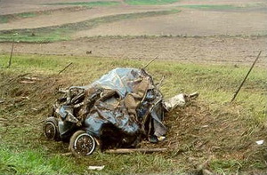
This vehicle was destroyed by a tornado - if you were in it, would you have survived?

It is my opinion that the traditional recommendations of the National Weather Service are the best choice. As we wrote in our Severe Weather 101 – Tornadoes and tornado safety article:

When driving in open country and you see a tornado, simply drive away from the path of the tornado – usually at a 90 degree angle to the path is best. While we all have seen video of people doing it, do not seek shelter beneath a highway underpass as these act like wind tunnels and actually serve to increase the wind speed and collect flying debris. In the extreme situation that you simply cannot get away from a tornado, abandon your vehicle immediately. Lie down in a ditch or culvert and cover your head. This isn’t a particularly good option, but it is safer than remaining in a vehicle.

If you are caught outside with no place to seek shelter, crawl into a ditch or culvert and cover your head. Getting as low as possible will decrease the odds of you being struck by flying debris. This is not ideal, but it is your best course of action.

Ideally you would of course escape the tornado by outrunning it as outlined above or seek shelter in a sturdy building – knock on doors if you have to.

Justin Berk, Baltimore Weather Examiner and professional meteorologist had this to say:

If you are that close to a tornado, pray! If the option to drive the other way is not available… it is luck of the draw. I used to tell my students to get out and curl down in a low ditch by the road with their heads covered – to protect from flying debris. Honestly, who is going to think of getting outside when it gets worse? The car may provide some protection from flying debris. Which in a tornado, could be another car. I can see the fault in getting out of your car, only to get hit by another. The myth of hiding under a highway overpass has been proven wrong. So, drive away or pray!

Storm spotter training gets started this coming week

Want to be an official storm spotter or maybe just want to learn more about severe weather?  Here’s your chance!
Want to be an official storm spotter or maybe just want to learn more about severe weather? Here’s your chance!

We have written before about the great opportunity the National Weather Service provides by giving storm spotter training during the start of the severe weather season.  That time is now here and training sessions start in the coming week and new sessions have been added since we last reported on the topic.

The storm spotter program is a nationwide program with more than 280,000 trained spotters.  These volunteers report weather hazards to their local National Weather Service office providing vital information when severe strikes.  Data from spotters include severe wind, rain, snow measurements, thunderstorms and hail and of course tornadoes. 

Don’t think tornadoes can hit Thornton?  Click here for a look back at the June 3, 1981 twister that hit the city!

Storm spotters are part of the ranks of citizens who form the Nation’s first line of defense against severe weather. There can be no finer reward than to know that their efforts have given communities the precious gift of time–seconds and minutes that can help save lives.

By completing one of these training classes you can become an official storm spotter.  When severe weather strikes, you can report it by calling a special toll free number or submit your report via the National Weather Service’s website.

These are great sessions for anyone wanting to learn more about the severe weather we experience in Colorado, whether you want to be an official spotter or not.  All training is free.  Topics include:

  • Basics of thunderstorm development
  • Fundamentals of storm structure
  • Identifying potential severe weather features
  • Information to report
  • How to report information
  • Basic severe weather safety

To learn more about the program, see here:  http://www.crh.noaa.gov/bou/awebphp/spotter.php

Here are the dates, times and locations announced thus far (click here to go to the NWS site for the latest). 

 
March, 2009 – Upcoming
Day City, State Time Location
05 Greeley, CO
(Weld County)
6:30pm MST Weld County Training Facility 1104 H Street Greeley, CO
  Contact Information: rrudisill@co.weld.co.us
19 Westminster, CO
(Adams County)
6:30pm MDT Front Range Community College 3645 West 112th Ave. room C0804 Westminster, CO 80031
  Contact Information: Ryan.Girard@frontrange.edu
23 Julesburg, CO
(Sedgwick County)
6:30pm MDT Julesburg Fire Hall
  Contact Information: ptsports57@yahoo.com
24 Holyoke, CO
(Phillips County)
9:00am MDT location to be determined.
  Contact Information: Philcoadmin@pctelcom.coop
24 Haxtun, CO
(Phillips County)
6:30pm MDT location to be determined
  Contact Information: fix5@haxtuntel.net
30 Westminster, CO
(Adams County)
2:30pm MDT Front Range Community College 3645 West 112th Ave. room C0804 Westminster, CO 80031
  Contact Information: Ryan.Girard@frontrange.edu
31 Sterling, CO
(Logan County)
6:30pm MDT Sterling Fire Hall Community room, 420 S. Oak Street
  Contact Information: OWENS@sterlingcolo.com
 
April, 2009 – Upcoming
Day City, State Time Location
02 Loveland, CO
(Larimer County)
9:00am MDT Rialto Theater 228 East 4th Street Loveland, CO 80537
  Contact Information: mialyp@ci.loveland.co.us
02 Fort Collins, CO
(Larimer County)
7:00pm MDT City Council Chambers 300 Laporte Avenue Fort Collins, CO
  Contact Information: nilssoed@co.larimer.co.us
06 Brush, CO
(Morgan County)
7:00pm MDT Morgan County Fairgrounds Ellsworth Street, Brush
  Contact Information: senfante@co.morgan.co.us
14 Commerce City, CO
(Adams County)
1:00pm MDT Adams County Sheriff’s Dept. 4201 East 72nd Avenue Commerce City, CO 80022
  Contact Information: JSchwarz@co.adams.co.us
22 Akron, CO
(Washington County)
6:30pm MDT Washington County Fairgrounds Event Center, Akron
  Contact Information: mmcaleb@co.washington.co.us
23 Parker, CO
(Douglas County)
7:00pm MDT Parker Fire District HQ 10235 Parkglenn Way Parker, CO
  Contact Information: kc0mht@msn.com
 
May, 2009 – Upcoming
Day City, State Time Location
02 Denver, CO
(Denver County)
9:00am MDT Denver Police Station 3 1625 South University, Denver
  Contact Information: Mike.Rappe@denvergov.org

Nature Unleashed – New exhibit to highlight weather and natural disasters

"Nature Unleased - Inside Natural Disasters" comes to the Denver Museum of Nature and Science this weekend.

The Denver Museum of Nature & Science opened a new traveling exhibit titled “Nature Unleashed – Inside Natural Disasters” Friday.  This extraordinary exhibit runs through Wednesday, May 3rd. 

The new exhibit will cover the entire gamut of major natural disasters including earthquakes, hurricanes, tornadoes, and volcanoes.  A special ‘Colorado Connections’ section will take a look at the Colorado’s volcanic history as well as the various types of severe weather that affect the state.  Drought, floods, wildfire, blizzards, climate change and tornadoes are all discussed in depth. 

According the museum:

From earthquakes and volcanoes to hurricanes and tornadoes, nature’s forces have shaped our dynamic planet. Throughout history, these catastrophic phenomena have affected people around the world. Now, uncover the causes of these natural disasters and find out how people cope and adapt in the aftermath. In this captivating, interactive new exhibition all of nature’s power is on display at the Denver Museum of Nature & Science.

In addition to the exhibits, the museum has lined up a great slate of additional events including lectures on the following:

  • Grand Canyon Adventure: River at Risk
  • Storm Chasing
  • Natural Disasters on Other Planets
  • Natural Disasters in Film

Also not to be missed are tours they have arranged for:

  • NCAR Mesa Lab in Boulder
  • National Oceanic and Atmospheric Administration (NOAA) in Boulder
  • National Earthquake Information Center in Golden

Be sure to visit the Denver Museum of Nature & Science website for all the details on this great exhibit.

11th annual Storm Chaser Convention coming to Denver

Get ready for ChaserCon - Coming to Denver in February!

The 11th annual National Storm Chaser Convention is coming to Denver from February 13th to the 15th.  Organized by storm chasers Roger Hill and Tim Samaras, this event brings together amateur and professional storm chasers, meteorologists, climatologists and experts from across a wide spectrum dealing with weather.  It is a great opportunity to learn not just about storm chasing but also about the weather in general.

As usual, a great slate of speakers has been lined up including:

More than lectures though, the convention features screening of some of the most incredible tornado footage from the past year as well as a hands-on look at the latest in weather gadgetry.  On the afternoon of the 15th, the National Weather Service will also be holding an official storm spotter training session that is open to the public. 

You can learn more about this great event and see the complete agenda on the convention website at www.chaserconvention.com.

Best books to give to the weather enthusiast

Today we’ll take a look at some of the best books out there for the weather enthusiast in your life as well as for kids interested in learning more about the weather.

Weather-related gifts for the “weather geek” in your life abound.  From books to increase ones knowledge of weather to personal weather stations and even clothes and novelties all make great gifts this holiday season.  Today we’ll take a look at some of the best books out there for the weather enthusiast in your life as well as for kids interested in learning more about the weather. 

ThorntonWeather.com’s top four weather books for the weather enthusiast

Colorado Weather Almanac – Written by Mike Nelson of Denver’s KMGH channel 7, this is the definitive book about Colorado weather.  Everything from how our geography impacts the weather in Colorado to historical weather information to storm chasing is covered.  This is highly recommended.  Click here to read my full review of the book.

The Weather Book: An Easy-to-Understand Guide to the USA’s Weather – By Jack Williams of USA Today, this covers the entire gamut of weather phenomena and conditions all with the beautiful illustrations USA Today’s weather section is famous for.  This easy to read book is a great one for those wanting to learn more about the weather but it also has plenty of in depth information for even those already well versed on the basics. 

Weather: The Ultimate Book of Meteorological Events – This newly released hardcover book has some of the most beautiful (and scary) photos you will ever see of weather events.  Accompanied by essays from meteorology and climate change experts, book has 20 years worth of photos of significant weather events.  Also included are U.S. and international monthly climactic data charts, 365 days of weather trivia and significant events in meteorological history.

Adventures in Tornado Alley: The Storm Chasers – Quite simply, wow!  The images this book contains will amaze and astound you.  Professional storm chasers Mike Hollingshead and Eric Nguyen document some of their most incredible chases across the nation’s midsection in photographs and text.  Absolutely stunning imagery.  

Three weather books for kids

The Kids’ Book of Weather Forecasting – For your 3rd to 5th grader, this book provides a great primer for kids interested in learning more about the weather.  Beautiful illustrations make the topics easy to understand and experiments like making a barometer and rain gauge gives kids a hands-on experience.

Storm Chasers! On the Trail of Twisters – Written for kids 7 – 13 years old by veteran storm chasers, this helps to explain severe weather to youth.  Colorful illustrations help kids become familiar with various types of storms, learn how to spot them and teaches them storm chasing safety and responsible storm chasing behavior. 

The Weather Detectives – This book chronicles three kids as they investigate weather phenomena like the causes of tornadoes, hurricanes, ice and hail storms, flash floods, the Northern Lights, and more.  Written by a professional meteorologist, this book is sure to educate and entertain.

ThorntonWeather.com sneak peek – Storm Chasers episode 4 preview

The probe trucks await an opportunity to deploy their instruments on Discovery Channel's Storm Chasers.

We continue to be granted sneak peeks of new episodes of the Discovery Channel’s Storm Chaser’s (Sunday’s @ 8:00pm MST).  Last week corn husks fell from the sky on the scout crew after a tornado had passed and Reed and the TornadoVideos.net team chased a twister in the dark. 

As the show chronicles the 2008 storm season, it is now getting into what was the most intense period of the summer.  This coming Sunday’s episode guide says:

NIGHTMARE ON DOW STREET – Nov. 9 at 10 p.m. ET/PT
Halfway into the season, TIV1 returns to action, and the whole team heads first toward Oklahoma and then into Arkansas. Monster hail storms batter the fleet, but the vehicles forge ahead as tornadoes start touching down all across this part of the Great Plains. Everyone gets to feast on the tornado bounty, but after dark, a twister chases the chasers in the streets of Stuttgart, Arkansas.

This week’s episode sneak peek –  The storm chasers race to outrun a devastating twister as it quickly catches up to the team’s TIV-1 vehicle in this clip from Storm Chasers.

Wild Western Weather 2008 announced

Wild Western Weather 2008 will be held on November 18th.

The channel 7 24 / 7 Weather Center has accounced an exciting event – Wild Western Weather 2008.  The event will be held at the Wild Life Experience in Parker on Tuesday, November 18th from 6:00pm to 10:00pm.  This looks to be a great event with a number of notable speakers.  

Some of the highlights include: 

  • Tim Samaras – Tornado Expert – featured in National Geographic Magazine, “Inside Tornadoes – The Latest Research: Twistex 2008” 
  • Tony Laubach – Storm Chaser – “The Windsor Tornado vs Douglas County Landspouts” 
  • Dr. Walt Lyons – Lightning Researcher – “Flash Facts – Red Sprites, Blue Jets and Other Rare Airities” 
  • Ethan Green – Director, Colorado Avalanche Information Center – “Avalanches and the Big Snow Winter of 2007-08” 
  • Dr. Thomas Schlatter – NOAA’s Earth System Research Lab and the University of Colorado – “The Pine Bark Beetle – A Canary for Climate Change?”
  • I do wish they had chosen a more central location for it or at least held the event on the weekend.  It is pretty tough for anyone who works and lives north to try to make it down there. 

    For more information, check it out on channel 7’s website here:  http://www.thedenverchannel.com/weather/5103957/detail.html

    2009 National Storm Chaser Convention dates announced

    The 2009 National Storm Chaser convention will be February 13 - 15, 2009.
    The 2009 National Storm Chaser Convention will be February 13 - 15, 2009.

    The dates for the 11th annual National Storm Chaser Convention have been announced.  The event will be held February 13th to the 15th at the Red Lion Inn in Parker.  As usual there looks to be a great lineup of speakers and of course it will certainly be informative and fun.  The agenda is still being finalized but some of the highlights announced thus far include:

    This year’s convention promises to be the biggest and best yet! The convention is held each year in Denver, Colorado, and is geared for you, the storm chaser, spotter and storm enthusiast, to be the premiere gathering of the year. Because of the intense severe storm and hurricane season that 2008 brought, we have been able to gather some of the best scientists and forecasters in the world to present at this year’s convention. Dr Steve Lyons, hurricane expert for The Weather Channel, will be this year’s keynote speaker. From the National Hurricane Center, we welcome lead forecaster Dr Jack Bevens.

    On the severe storm side, we welcome Dr Greg Forbes from The Weather Channel, and are also excited to welcome back Dr Howie Bluestein. We are also excited to have Rich Thompson, lead forecaster at the Storm Prediction center, as well as meteorologist Jon Davies. Tim Marshall will once again bring is attention getting presentation to our convention. We have several other speakers that you won’t want to miss!!! So sign up early and tell all your friends to come to the 2009 National Storm Chaser Convention.

    For more information, visit the convention website at:  http://chaserconvention.com/

    ThorntonWeather.com junior stormchaser chases tornado for 7News

    ThorntonWeather.com junior stormchaser Bobby pursued a tornado in Weld County yesterday and provided live reports for 7News.  Watch the video below (you may need to turn up the sound due to a lot of background noise).

    [hana-flv-player video=’https://www.thorntonweather.com/blog/wp-content/uploads/2008/10/7news.flv’ /]

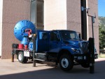
    The DOW - Doppler On Wheels - as seen on Storm Chasers.
    The DOW - Doppler On Wheels - as seen on Storm Chasers.

    🙂  Okay, so maybe not but it still is kind of fun.  This was taken yesterday at NCAR’s Super Science Saturday in Boulder.  Channel 7 was there with their “24 / 7 Weather Experience” which was a lot of fun as it gives folks a small taste of what goes into a weather broadcast.  Unfortunately Mike Nelson, author of our favorite weather book, wasn’t there when we were but this was probably the highlight of the day up at NCAR for the kids.

    There was also a bit of a celebrity there too as Justin Walker from Discovery Channel’s Storm Chasers TV show was there with their Doppler On Wheels (DOW) truck – a mobile radar vehicle.  Justin serves as one of the team members from the Center for Severe Weather Research that chases the storms.  He in particular is tasked with placing scientific probes in the path of the tornadoes.  We got to spend a good bit of time chatting with Justin about their chases this past tornado season and in particular the ones in the north central Kansas area where a good bit of my family lives.  He had some fascinating anecdotes to share about the storms, in particular the one that struck near Glen Elder, KS.

    Bobby with Justin Walker of Storm Chasers.
    Bobby with Justin Walker of Storm Chasers.

    For those that didn’t make it up there, you really missed a great opportunity for kids to learn more about not only the weather but also things like energy, the environment and more.