Category Archives: National Weather

“Double Rainbow Guy” video makes YouTube’s top 10 of 2010

Video of a double rainbow shot by a man living near Yosemite National Park has been named one of YouTube's top videos of the year.

Rainbows are certainly one of Mother Nature’s most beautiful weather-related phenomena.  One man’s excited reaction to a double rainbow became a YouTube hit earlier this year and has now been named the sixth most popular video of 2010.

Shot from near the man’s home in one of the nation’s premier parks, Yosemite, his sheer elation to the rainbow invites reactions ranging from laughter to tears from those who have watched it. 

Published on YouTube on January 8th the video has been watched more than 21 million times since and led to the “Double Rainbow Guy” making an appearance on the Jimmy Kimmel Show.

In a blog entry announcing “The Moments that Defined YouTube in 2010”, the service said the video became “one of the most beloved memes of 2010.”

The weather-related video ranked as number six on the list of top 10 most-watched YouTube videos falling behind the popular video of Greyson Chance singing Paparazzi and an Old Spice commercial.  The double rainbow video did beat out the infamous video of Justin Bieber surprising a young fan and a trailer for the latest Twilight Saga movie

We of course think that the video we shot while storm chasing in southeastern Colorado deserves an honorable mention.  😉

You can watch the Yosemitebear’s video below.

Oregon town struck by rare EF-2 tornado

An EF-2 tornado struck the town of Aumsville, Oregon on Tuesday damaging 50 structures. Click the image for a slideshow of the damage from Examiner.com.

Tornadoes are not usually asssociated with Oregon or December and certainly not the two of them together.  Tuesday however that rarest of event did occur when an EF-2 tornado packing 110+ mph winds struck the town of Aumsville.

The first report of the tornado was at 11:59am PST when emergency personnel reported spotting the twister.  Power was knocked out to thousands and several homes and businesses were damaged or destroyed.  Two minor injuries were reported. 

The National Weather Service completed their preliminary investigation of the twister and rated the tornado as an EF-2 with winds between 110 and 120 mph.  At its maximum the twister was 150 yards wide and carved an intermittent path 5 miles long. 

For more details on the tornado including video and a photo slideshow of the damage, please visit the Natural Disasters Examiner.

Snow across western United States imaged by NASA satellite

Widespread snow from the Sierra Nevada to the Colorado Rockies snarled travel leading up to the Thanksgiving holiday.  As the holiday weekend wraps up, NASA has released satellite imagery showing just thousands of square miles coated in a blanket of white.

Read more below the image.

NASA's Terra satellite captured stunning imagery of the pre-Thanksgiving snow across the western United States.

The winter weather conditions delayed flights and forced road closures starting last weekend and lasting up to Thanksgiving.  Some of the snow totals from Saturday the 20th through Saturday the 27th include:

  • Salt Lake City, Utah – 9.9 inches
  • Pocatello, Idaho – 9.0 inches
  • Boise, Idaho -5.0 inches
  • Elko, Nevada – 8.4 inches
  • Yakima, Washington – 6.2 inches
  • Missoula, Montana – 8.4 inches

Much higher amounts were recorded in the higher elevations making for very happy ski resorts and skiers.  Alpine Meadows near Lake Tahoe reported 8.5 feet of snow at mid-mountain.  In Wyoming, Jackson Hole opened all of its runs on its opening day, the first time it has been able to do so in 45 years.

In western Colorado ski areas were very happy to receive the snow leading up to the busy holiday season with Steamboat having its best opening in 10 years. Loveland Ski Area reported nearly 3 feet of snow depth at mid-mountain. 

The image released by NASA and taken by its Terra satellite show a wide swath of snow cover from Oregon across Nevada, Idaho and Utah to Colorado. Click on the image to the above left to view the full size, high resolution image.

From NASA:

In most of the western part of the United States, Thanksgiving Day came with a coating of snow. Ski resorts from California’s Lake Tahoe region to the Colorado Rockies reported several feet of snow from a storm system that passed through in the days before, bringing a welcome early opening to the ski season. Travelers throughout the West, however, did not share skiers’ enthusiasm for the weather. Winter weather advisories were causing flight delays and cancellations throughout the northwestern-most states. The same storm system that brought as six inches of snow to Utah and Idaho on November 23 also brought heavy snow to North Dakota and Minnesota the next day. Severe wind chill conditions were reported throughout the Great Plains on November 25 as well.

This image shows a portion of the western U.S. on November 25, 2010 (Thanksgiving Day). It was acquired by the Moderate Resolution Imaging Spectroradiometer (MODIS) on NASA’s Terra satellite. White snow decorates the ground from California’s Sierra range eastward throughout Nevada, Utah, and Colorado, ending at the front range of the Rockies in Colorado. Further north along the top edge of the image, the snow runs solidly from Oregon to Idaho and Wyoming off the northern and eastern edges of the image.

Strong cold front brings tornadoes, damaging wind to Illinois and Wisconsin

Path of EF2 tornado in Illinois on November 22, 2010. (NWS)

November is not normally the time of year for tornadoes, least of all in states in northern latitudes like Illinois and Wisconsin.  That however did not stop a mini-outbreak yesterday as at least two tornadoes struck and as many as seven were possible.

  • Watch video of the twister below

Severe thunderstorms were spawned yesterday by a strong cold front moving across the upper Midwest.  The twisters were the first in 26 years to strike the area in November – you have to go all the way back to November 9, 1984 to find the last one.

The National Weather Service has confirmed that the strongest of the tornadoes yesterday was an EF2 packing winds of 135mph.  It covered a path of 16.4 miles and had a maximum width of 200 yards.  The twister overturned a bus, caused significant damage to buildings and injured six people. 

Below you can see a video of the twister as it passed near Loves Park, Illinois.

Father and son from Brooklyn send iPhone and video camera into space

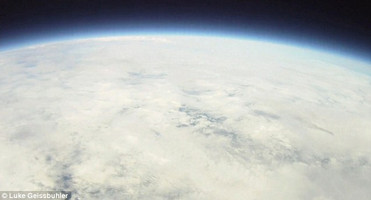
A weather balloon launched by a father and son from Brooklyn captured high definition video from the stratosphere. (Luke Geissbuhler)

How hard would it be to send a craft into space and capture video?  Apparently it isn’t all that difficult as evidenced by a father and son who launched a weather balloon carrying an iPhone and high definition video camera to an astounding altitude of nearly 100,000 feet. 

Calling themselves the Brooklyn Space Program, Luke Geissbuhler and his seven-year-old son Max created the craft that flew into the stratosphere.  The flight lasted 102 minutes, reached an altitude 19 miles  and landed 30 miles from its launch location in rural New York.

On board the craft was a high definition video camera that captured all but the final two minutes of the flight.  Tracking of the balloon was done using an Apple iPhone with a GPS application that allowed for a real time tracking and a quick recovery.

Geissbuhler said he had always been one to tinker and enjoyed working on projects with his son.  He had not given this endeavor a very good chance telling the U.K.’s Daily Mail, “Even after months of research and testing – we only had a 30 per cent chance it would work. We got very lucky.”

You can watch the amazing video from the flight below.

On the net: Brooklyn Space Program

New York City tornadoes confirmed – Rare event also brings 125 mph winds

In a rare occurrence, two tornadoes struck the New York City boroughs of Brooklyn and Queens on Thursday, September 16, 2010.
In a rare occurrence, two tornadoes struck the New York City boroughs of Brooklyn and Queens on Thursday, September 16, 2010. View more images in the slideshow below.

Severe weather struck the Big Apple this past Thursday and brought with it only the sixth and seventh tornadoes to strike New York City since record keeping began in 1950.  Accompanying the storms were straight-line winds packing a 125 mph punch. 

Funnel clouds were spotted in the boroughs of Queens and Brooklyn from the storms that also brought extraordinary winds and driving rain.  The severe thunderstorm toppled trees and power lines and left one woman dead.

The National Weather Service sent a team to look at the damage and determine if the winds were the result of a tornado or straight-line winds.  The answer is that two tornadoes -one an EF0 on the Enhanced Fujita Scale, the other an EF1 – struck Brooklyn and Queens.

In the Park Slope Neighborhood of Brooklyn, the tornado touched down at about 5:33pm and ripped across the cityscape for two miles.  It generated winds of 80mph, an EF0, and had a maximum width of 75 yards. 

Slideshow - Twin tornadoes strike Brooklyn and Queens, New York.The second twister struck the Flushing / Bayside area in Queens and was stronger and longer lived.  That tornado packed winds of 100mph making it an EF1.  It reached a maximum width of 100 yards and was on the ground for four miles.  One fatality is attributed to the twister as Iline Leuakis of Pennsylvania was killed when a tree fell and crushed her car. 

Also notable were significant straight-line winds caused by a macroburst.  In the Middle Village and Forest Hills areas in Queens, winds reaching 125 mph with a path five miles wide and eight miles long contributed to the damage. 

The two tornadoes mark only the sixth and seventh tornadoes to strike in the five counties that make up New York City since 1950 – Bronx, Kings, New York, Queens, Richmond.  The strongest occurred on August 8, 2007 and was an EF2 that caused nine injuries.

New York City’s Tornadoes – Since 1950

  • 1985-10-05, Queens County, EF1
  • 1990-08-10, Richmond County, EF0
  • 1995-10-28, Richmond County, EF1
  • 2003-10-27, Richmond County, EF0
  • 2007-08-08, Richmond & Kings Counties, EF2
  • 2010-09-16, Kings County, EF0
  • 2010-09-16, Queens County, EF1

Data courtesy the Tornado History Project

Record-setting hail falls near Wichita, Kansas

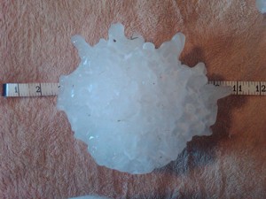
A monstrous hailstone measuring 7.75 inches in diameter fell near Wichita on September 15, 2010, setting a new record for Kansas.
A monstrous hailstone measuring 7.75 inches in diameter fell near Wichita on September 15, 2010, setting a new record for Kansas. (National Weather Service / Melissa McCarter)

Severe weather rolled through south-central and southeastern Kansas on the evening of Wednesday, September 15, 2010 and dropped tornadoes and potentially record-setting hail.  The supercell thunderstorms developed in the late afternoon and caused significant damage in the Wichita area.

  • Watch video of the hail pounding Wichita below

In Sedgwick and Cowley counties one supercell generated monstrous hail on the western side of Wichita.  The largest stone, right, was measured at 7.75 inches and fell at about 6:00pm in West Wichita.  According to the National Weather Service the chunk of ice weighted 1.1 pounds and was 15.5 inches in circumference. 

It has been preliminarily confirmed that the diameter of the hailstone from Wednesday easily eclipsed the state’s previous record setter of 5.7 inches in diameter – a hailstone that fell on September 3, 1970 near Coffeyville.  It does fall short of the all-time largest hailstone which fell on July 23rdof this year and measured 8.0 inches in diameter.

Hail from golf ball to softball sized swept across a large area breaking windows in homes and smashing vehicles. At Mid-Continent Airport the hail broke through skylights and damaged the facilities airport.  Several planes sustained damage as well. 

Video - Monstrous hail falls in Wichita, Kansas on Wednesday, September 15, 2010.Strong, straight-line winds up to 80 mph were recorded in Cowley, Wilson, Labette and Cherryvale counties.  Downed power lines resulted in 10,000 people being without power at one point.

Five tornadoes were reported south, southeast and east of Wichita.  The twisters were on the ground for short periods of time and did not appear to directly cause any damage.  All have been rated EF0 with winds from 65 mph to 85 mph by the National Weather Service.

Related stories on Examiner.com

Why do we link to Examiner.com?

That’s a big chunk of ice! South Dakota hailstone sets world records

A massive hailstone with a diameter of 8 inches will likely set the record as the largest hailstone in terms of diameter and weight. (NWS)
A massive hailstone that fell in South Dakota on July 23rd set world records for diameter and weight. (NWS)

The massive hailstone that fell over rural South Dakota last week has officially set world records for its weight and diameter. According to the National Oceanic and Atmospheric Administration (NOAA) the chunk of ice easily eclipsed the previous record setter.

On Friday, July 23rd, severe weather rolled through northeastern South Dakota and Stanley, Jones, and Lyman counties. With it was massive hail so big it left holes in the ground the size of coffee cans. Les Scott, a ranch hand, recovered the now record setting stone afterwards.

NOAA’s National Climate Extremes Committee determined that the huge chunk of ice from the sky officially measured 8.0 inches in diameter and weighed 1.9375 pounds (1 pound, 15 ounces) setting records for both. It also measured 18.62 inches in circumference falling just short of breaking the record for that measurement.

The previous record holding hailstone in terms of weight fell on September 3, 1970 in Coffeyville, Kansas and weighed 1.67 pounds.

The stone that previously held the record for diameter measured 7 inches and fell in Aurora, Nebraska on June 22, 2003. That stone still holds the record for circumference having measured 18.75 inches.

While Scott froze it immediately, David Hintz, a meteorologist at NOAA’s Aberdeen weather forecast office, said in a statement some melting had probably occurred resulting in the official measurements being smaller than what the stone was when it first fell.

“Mr. Scott told me the area was littered with large hailstones and the largest had a greater diameter when he first found it. He immediately stored it and several others in his freezer, but a power outage caused some melting,” Hintz said.

While the east roasts, the west chills – Record temperatures of both extremes in the U.S.

Record heat strikes the northeastern U.S. while southern California sees record low maximums.  Denver may see its own temperature record today. (Examiner.com)
Record heat strikes the northeastern U.S. while southern California sees record low maximums. Denver may see its own temperature record today. (Examiner.com)

Triple digit heat broiled the northeastern United States on Tuesday while record setting cool weather struck southern California. Denver may be next to see cool temperatures for the record books as the United States experiencing a wide variety of temperatures.

On the East Coast, temperatures exceeding 100 degrees struck from Virginia north to Massachusetts. Many of the temperatures recorded set new high temperature records for the date including:

  • Allentown, PA – 101 degrees (old record 100 degrees set in 1999)
  • Atlantic City, NJ – 102 degrees (old record 99 degrees set in 1999)
  • Baltimore, MD – 105 degrees (old record 101 degrees set in 1999)
  • Newark, NJ – 103 degrees (old record 102 degrees set in 1999)
  • New York City, NY (Central Park) – 103 degrees (old record 101 degrees set in 1999)
  • Philadelphia, PA – 102 degrees (old record 98 degrees set in 1999)
  • Warwick, RI – 102 degrees (old record 97 degrees set in 1999)
  • Wilmington, DE – 103 degrees (old record 98 degrees set in 1999)
  • Windsor Locks, CT – 102 degrees (old record 99 degrees set in 1999)

On the opposite coast of the nation, record low maximum temperatures were recorded from San Diego up to Riverside. Low pressure and a thick marine layer of clouds held temperatures down and residents that would normally be wearing shorts and tank tops traded that clothing for jeans and sweatshirts.

Among the tied or broken record low maximums recorded in southern California on Tuesday were:

  • Escondido – 69 degrees (old record 78 set in 1987)
  • Laguna Beach – 62 degrees (old record 68 set in 1968)
  • Newport Beach – 66 degrees (tied record of 66 last set in 1995)
  • Oceanside Harbor – 62 degrees (old record 65 set in 2002)
  • Riverside – 79 degrees (old record 80 set in 1969)
  • San Diego – 65 degrees (tied record of 65 last set in 1912)

On Wednesday, both the northeastern United States and southern California may see those record-setting temperature trends continue.

Denver also stands a chance to see a record setting low maximum today. The forecast for Denver International Airport where Denver’s official temperature measurements are now taken is for a high of 63 degrees today. The current record low maximum is 65 degrees last set in 1952.  Here in Thornton we will see similar temperatures.

Tropical Storm Alex threatens Gulf of Mexico oil spill cleanup

Satellite image of Tropical Storm Alex as it prepares to cross the Yucatan Peninsula. (NOAA / Google Earth)  Click the image for a complete slideshow of the storm and its forecast path.
Satellite image of Tropical Storm Alex as it prepares to cross the Yucatan Peninsula. (NOAA / Google Earth) Click the image for a complete slideshow of the storm and its forecast path.

The first named storm of the 2010 hurricane season is being watched closely by not only areas at threat from landfall but also those working to clean up the Gulf oil spill. Tropical Storm Alex continued to move to the northwest where it threatens to find warmer water and become a hurricane.

The National Hurricane Center (NHC) places the center of Alex at the current time 75 miles east of Belize City. The storm is packing winds of 45 mph and moving to the west-northwest at 9mph.

On its current path, Alex will reach the coast of Belize and the Yucatan Peninsula late today and move across the peninsula on Sunday. By Sunday night or early Monday morning, it will have transited land and emerge in the Bay of Campeche.

Get all the latest on Tropical Storm Alex including amazing satellite animation video, forecasts and more from the Natural Disasters Examiner.