Category Archives: National Weather

85 years ago today – The nation’s deadliest tornado

A Chicago Herald Examiner headline covering the Great Tri-State Tornado of 1925. (Wikipedia)  Follow the link below for images of the destruction.
A Chicago Herald Examiner headline covering the Great Tri-State Tornado of 1925. (Wikipedia) Follow the link below for images of the destruction.

News reports portray a dreary start to March 18, 1925 with heavy rain in the morning but nothing that would foretell the disaster that was to come. Before the day was over, parts of Missouri, Illinois and Indiana would be torn asunder and nearly 700 people would be dead.

Today marks the 85th anniversary of what we now call the Tri-State Tornado. The deadly twister was of the likes that had never been seen before – and hasn’t been seen since. That morning, the U.S. Weather Bureau’s forecast called for “rains and strong shifting winds.” Nothing that would indicate the horror that was to come.

The first reports of the tornado happened at 1:01pm near Ellington, Missouri. As it moved to the northeast the twister tore through the towns of Annapolis, Redford, Cornwall, Biehle, and Frohna. By the time it exited Missouri, 11 people were dead.

Illinois bore the brunt of the tornado as it continued on its deadly path. It crossed the Mississippi River and tore through Gorham, Johnston City, Murphysboro, De Soto, Hurst-Bush and a half dozen other Illinois towns. Entire towns were reduced to rubble, over a thousand people were injured and 613 people in the state were dead.

Far from over, the twister crossed into Indiana where the towns of Griffin, Owensville, and Princeton were hit. 71 people are thought to have died in the state.

The horror finally came to an end at 4:30pm, three and a half hours after it started. The tornado dissipated southwest of Petersburg, Indiana but not until after it had covered a path of at least 219 miles and left death and destruction the entire way. From southeastern Missouri, completely across southern Illinois and into southwestern Indiana, the tornado was the longest tracking twister ever recorded.

For more about the deadly tornado, maps of the path and images of the aftermath, read the complete story on the Natural Disasters Examiner.

North Dakota & Minnesota brace for widespread flooding

More than a third of the contiguous United States has an above average flood risk currently. (NOAA) Click on the image for photos from the flood preparations in North Dakota and Minnesota.

With the Red River continuing to rise and expected to crest at more than 20 feet above flood stage, communities in North Dakota and Minnesota are preparing for widespread flooding. Weather forecasters are expecting that the river may approach the record levels seen just last year, potentially flooding hundreds of square miles.

The filling of sandbags and reinforcing dikes and levees has taken on a sense of urgency along the river.

In Fargo, North Dakota, the Red River was already nearly 13 feet above flood level Wednesday morning – major flood stage by National Weather Service standards. It is forecast to rise seven more feet by Sunday morning.

NOAA Administrator Jane Lubchenco warned in a statement that it flooding is likely to be extensive. “It’s a terrible case of déjà vu, but this time the flooding will likely be more widespread. As the spring thaw melts the snowpack, saturated and frozen ground in the Midwest will exacerbate the flooding of the flat terrain and feed rising rivers and streams.”

For more on what President Obama and the governors of those states are doing to help residents, read the complete story on the Natural Disasters Examiner.

Tornado claims the life of an elderly man in Arkansas; First tornado fatality of the year

Radar image of the tornado in White County, Arkansas. Two other twisters were reported in the state Wednesday, one that claimed the life of an elderly man. (NWS)

Tornadoes tore through Arkansas late yesterday and claimed the first tornado victim of 2010. One person was reported dead and three injured as the series of storms moved across the state.

The first twister of the night struck at 6:28pm local time in Saline County. That tornado damaged nearly two dozen homes but no injuries were reported.

The National Weather Service reported a second tornado was spawned out of a storm cell near Center Hill in White County. Nine homes were damaged and one person was injured.

The deadly twister was the third of the night which struck near Pearson in Cleburne County just after 9:00pm. Renee Preslar, spokeswoman for the Arkansas Department of Emergency Management, said that twister killed an elderly man and injured two others.

Thus far there has been a distinct lack of tornadoes reported in 2010. There were 41 twisters reported in January, slightly above the three year average for January of 37. That was followed by only one twister in February, the fewest in the month since record-keeping began in 1950.

There have been seven tornadoes reported thus far in March, all of which occurred in the last 48 hours.

Be sure to check out the Natural Disasters Examiner for all the latest on disasters from tornadoes and hurricanes to earthquakes and tsunamis!

Severe Weather Reports for Wedneday, March 10, 2010 (SPC)
Severe weather reports from the Storm Prediction Center for Wednesday, March 10, 2010

Video – Tornado rips through western Oklahoma

A tornado ripped through western Oklahoma on Monday destroying five homes and a barn. Dramatic video captured by stormchasers show the twister ripping apart out-buildings as it crosses a highway near Hammon.

According to the Storm Prediction Center, the twister was reported at 5:57pm local time. Residents said the area’s warning sirens did sound and provided nine minutes of warning before the tornado struck.

Oklahoma Department of Emergency Management spokeswoman Michelann Ooten told the Associated Press that no injuries were reported. In addition to the five homes, a barn owned by the county was destroyed and the roofs of several homes were blow off.

Stormchasers were tracking the storm and captured amazing video of the twister from the distance and from very close proximity.  The first is from Arick Inman and the second from Mike Scantlin.

Northeastern United States gets slammed by another winter storm

Satellite imagery of a major winter storm striking the northeastern United States, Friday, February 26, 2009. (NASA)

Yet another major winter storm smashed the northeastern United States on Friday snarling travel, closing schools and knocking out power to 1 million. The latest storm adds to the region’s astounding snow totals for the season and has already resulted in further breaking records.

With the latest storm, strong winds added another element to the heavy snowfall. From Pennsylvania through the nation’s capital to New York and New England, the havoc was widespread. All told, power companies across the region said more than 1 million residents and businesses were without power.

In New York, the city’s famed Central Park had received 16.9 inches of snow as of 7:00am today. That total gives the city 35.9 inches for the month sending February 2010 into the record books as New York City’s snowiest month on record.

Reflecting the extraordinary snow, New York Mayor Mike Bloomberg shuttered the nation’s largest public school district for the day. Three fatalities as a result of the storm have been reported, one of which was a man killed in Central Park when a snow-laden tree branch fell on him.

Other snow totals across the area were impressive. Greenwich, Connecticut reported 10.6 inches. Lodi, New Jersey led that state with 18.3 inches. In New York, Monroe reported 31.0 inches.

Rain was a problem on the northern parts of the storm system. Southern and coastal Maine is expected to receive up to 3 inches of rain prompting flood warnings in the state and in New Hampshire. Other portions of coastal New England were under similar advisories.

Travel was disrupted as well as more than 1,000 flights out of New York City’s three airports have been cancelled Friday. Philadelphia saw cancellations at its airport and ground travel was snarled.

As seen from space – Second blizzard’s snow spread across the East Coast

As seen from spance, snow covers the Mid-Atlantic from Washington D.C. through Baltimore and Philadelphia to New York City. (NASA)  See a larger image below.
As seen from space, snow covers the Mid-Atlantic from Washington D.C. through Baltimore and Philadelphia to New York City. (NASA) See a larger image below.

Whether it is called ‘Snowmageddon’, ‘Snowpocalypse’ or any other array of the names, the amazing series of winter storms that have struck the Mid-Atlantic States has been nothing short of astounding. Two storms struck the region in less than a week and NASA satellites have captured images of what the scene looks like from space after the second storm struck.

Baltimore, Washington D.C., Philadelphia, Wilmington and Atlantic City have all set new records for seasonal snowfall. Baltimore has recorded nearly 7 feet of snow so far this winter eclipsing the previous record by more than 17 inches.

All of those cities have recorded more snow than ones in the Rocky Mountain region. That also led to the unusual event of 49 of the 50 states having snow on the ground on the same day.

The image to the right and below was taken by NASA’s Terra satellite on February 11, 2010 after the second blizzard struck.

Second Blizzard Strikes U.S. East Coast
As seen from spance, snow covers the Mid-Atlantic from Washington D.C. through Baltimore and Philadelphia to New York City. (NASA)

Amazing winter allows 49 states to record snow on the ground

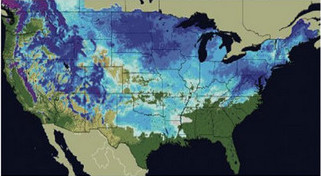
More than two thirds of the United States recorded snow no the ground on Friday.  (National Weather Service)
More than two thirds of the United States recorded snow no the ground on Friday. (National Weather Service)

It seems so improbable that no one was sure whether or not it has happened before but there was snow on the ground in 49 of the 50 states on Friday. The unlikely event was possible thanks to snow that hit unusual places like Texas and Florida.

According to the National Weather Service, 67.1 percent of the United States’ total land area was covered by snow yesterday. That far exceeds the 40 to 50 percent normally seen this time of year.

Dallas, Texas recorded an improbable 12.5 inches of snow breaking records for the date and pushing the city to its second snowiest winter on record and its snowiest in 32 years. Not to be left out, snow was on the ground in Arkansas, Alabama, Georgia and even the Florida Panhandle.

Residents in some places in the United States are wishing things weren’t nearly as snowy. The Mid-Atlantic region has experienced record setting snowfalls this year.

Baltimore, Washington D.C., Philadelphia, Wilmington and Atlantic City have all set new records for seasonal snowfall. Many of those cities have experienced more snow than their counterparts in the Rocky Mountain region.

So what was the one state that held out without snow? Hawaii. This is actually unusual as the Mauna Kea volcano peaks at 13,800 feet and often times has snow on it. Research meteorologist Tiziana Cherubini at the Mauna Kea Weather Center told the Associated Press the mountain had been without snow for a few weeks and none is in the forecast.

Officials at Rutgers University’s Global Snow Lab and with the National Weather Service are trying to determine if all 50 states have recorded snow on the ground at the same time. They have verified that 49 states have previously on January 19, 1977 when South Carolina was the lone holdout.

National Weather Service meteorologists attribute the snowy conditions to a moderate El Nino event in the Pacific Ocean and the Arctic Oscillation. In El Nino seasons, moisture streams across the south. The Arctic Oscillation brings colder air from the north dropping temperature and allowing any precipitation that might fall to turn to snow.

There's more to this story on Examiner.com!For a complete look at the crazy winter weather across the nation, be sure to visit the Natural Disasters Examiner.

It’s finally over – Mid-Atlantic digs out from record-setting snowstorms

The history making snowstorm that pushed many East Coast cities’ snow totals into the record books has moved out. Now residents begin the monumental task of digging out from snow depths the likes of which have never been seen.

Philadelphia, Washington D.C., and Baltimore were just some of the major cities on the east coast to be struck by what some have called ‘Snowmageddon.’ Last week a major winter storm dumped over two feet of snow on major cities in the Mid-Atlantic. Residents had just finished digging out from that event when Mother Nature delivered another wallop Tuesday and Wednesday.

Separately, the two storms in the past week and a previous one in December ranked each in many cities’ ‘top 10’ snow events. Collectively, the storms have dumped more snow than the region has ever seen in a single season.

How much snow fell?  Check out the astounding snowfall totals at the Natural Disasters Examiner.

From Philly to Washington to New York, East Coast slammed by blizzard

The adjectives to describe last week’s record-setting snowstorm no longer seem adequate to describe the winter weather striking from the Mid-Atlantic to New York. A second potentially more severe storm that the National Weather Service described as ‘life threatening’ is battering Washington D.C., Baltimore, New York City and every place in between.

Storms that dumped more than two feet of snow last week were bad enough but the latest storm has introduced another element – wind. Gusts of 35 mph to 45 mph are expected and coupled with snowfall amounts of more than a foot, snow drifts to four feet are forecast for some areas.

Widespread power outages are likely to become common as the wind and heavy snow takes its toll on an already taxed infrastructure. Road crews who were still working to clear the snow from the last storm are now struggling to stay ahead of the mounting snow totals.

Blizzard Warnings have been posted for Philadelphia, Washington D.C., Baltimore, and New York City. Forecast snow accumulations range from 6 to 12 inches in Washington to 12 to 22 inches in Philadelphia and 10 to 16 inches in New York City. Underscoring the dangerous conditions from the wind and snow, the National Weather Service warning said, “This is a life threatening situation for anyone who becomes stranded.”

Officials were urging all area residents to hunker down and wait the storm out. Public schools, businesses and even the federal government have ceased operations for the day.

There's more to this story on Examiner.com!For more details including the travel mess the storms have created and the astounding snow totals, see the complete story on the Natural Disasters Examiner.

‘Snowmageddon’ spotted by NASA satellite

e extent of snowfall from the major winter storm that struck the Mid-Atlantic states last week is easily seen from NASA satellites. (NASA) See a larger version below.
The extent of snowfall from the major winter storm that struck the Mid-Atlantic states last week is easily seen from NASA satellites. (NASA) See a larger version below.

This past Friday and Saturday the Mid-Atlantic states were smashed by a record-setting snowstorm that left more than two feet of snow in many areas. The snow brought the nation’s capital to a grinding halt and now the extent of the storm’s wrath can be seen from space.

NASA’s Terra satellite flew over the area on Monday and was able to capture amazing imagery showing the widespread snow cover. The image to the right and the larger version below clearly show Washington D.C., Baltimore, and Philadelphia buried under a significant blanket of white.

Even as area residents continue to dig out from the snow and power companies try to restore power to tens of thousands, a second blast of winter is set to arrive today. That storm may generate nearly as much snow and will certainly push most major cities in the area to record seasonal snowfall totals.

Heavy Snow around U.S. Capital – February 8, 2010 (NASA)
Heavy Snow around U.S. Capital - February 8, 2010 (NASA)