Category Archives: Natural Disasters

Before and after: NASA satellite imagery shows effects of Washington state landslide

As many as two dozen people were killed on Saturday, March 22, 2014 when a massive landslide swept down a rain-soaked hill near Oso, Washington. NASA satellite imagery taken before and after the event shows the extent of the event.

Using the ‘sliders’ on the image below you can compare how the area looks normally (left) versus how it looked after the landslide (right).

[wpw_ba_viewer width=”600″ height=”auto” anim_speed=”600″ start_percent=”0.5″ disable_intro=”false”]
[wpw_ba_img src=”http://lh6.googleusercontent.com/-I2mSOZBkFnQ/UzMQFKXi74I/AAAAAAAAB0s/tcA9N10o6cY/s600/wa-before.jpg” data_second=”http://lh5.googleusercontent.com/-VXmVfoDsFqQ/UzMQFPSNLNI/AAAAAAAAB0w/kIX2gla6sTA/s600/wa-after.jpg” title=”Satellite imagery comparison of the area near Oso, Washington before and after the March 22, 2014 landslide. (NASA EO)” data_info=”Satellite imagery comparison of the area near Oso, Washington before and after the March 22, 2014 landslide. (NASA EO)”]
[/wpw_ba_viewer]

From NASA:

On March 22, 2014, a rainfall-triggered landslide near Oso, Washington sent muddy debris spilling across the North Fork of the Stillaguamish River. The debris engulfed numerous homes, resulting in the deaths of at least 14 people. As of March 25, authorities reported that 176 people were still missing.

The slide left an earthen dam that blocked the river, causing a barrier lake to form. The Operational Land Imager (OLI) on Landsat 8 acquired this image of landslide debris and the barrier lake on March 23, 2014. An image of the same area acquired on January 18, 2014, is shown for comparison.

As water backed up, it raised fears of a potential flash flood. On March 23, water began to flow around the north side of the dam. However, as of the afternoon of March 25, a flash flooding watch issued by the National Weather Service remained in effect for parts of Snohomish county.

According to Durham University geologist Dave Petley, the landslide was a reactivation of an earlier landslide that caused problems in 1988 and 2006.

Video: Los Angeles news anchors scramble under desk during earthquake

Location map of the epicenter of the magnitude 4.4 St. Patrick's Day earthquake in Los Angeles.A magnitude 4.4 earthquake struck the Los Angeles area Monday morning in the pre-dawn hours. While a relatively minor quake, it was strong enough to rattling residents and send morning TV news anchors under their desks.

According to the US Geological Survey (USGS) the quake was centered 6 miles west of Beverly Hills and at a depth of 5.3 miles. Occurring at 6:25 a.m. local time, a light aftershock of magnitude 2.7 was recorded at 7:23 a.m.

Residents stretching from Mission Viejo to the south and Oxnard to the north reported feeling the initial temblor. Beyond waking residents that were still sleeping and grabbing the attention of those already awake, initial reports indicate no significant damage.

Television stations were in the middle of their morning broadcasts when the quake hit.

KTLA news anchors Chris Schauble and Megan Henderson reacted quickly announcing that they were feeling the quake. The two acted appropriately and dived under their anchor desks for the short duration of the quake.

Video from the station shows the overhead lights shaking and Henderson noting that dust or ceiling material was falling down.

NASA satellite captures image of Australian wildfires

Satellite imagery of wildfires is something we are certainly used to seeing here in Colorado, particularly the last couple of years.  Summertime in Australia brings wildfire danger as well and a NASA satellite captured smoke billowing from a blaze down under.

Much of Australia has been gripped by record-setting heat in recent weeks thus leading to the increased fire danger.  The image from NASA’s Aqua satellite shows one of the blazes burning.

From NASA:

“In January 2014, an intense heat wave and strong winds fueled an outbreak of hundreds of bushfires in South Australia. The Moderate Resolution Imaging Spectroradiometer (MODIS) on NASA’s Aqua satellite acquired this image of grass and shrub fires raging in Yumbarra Conservation Park on January 16, 2014. Red outlines indicate hot spots where MODIS detected unusually warm surface temperatures associated with fire. Northerly winds blew large plumes of smoke out over the Great Australian Bight. Members of the aboriginal community of Koonibba were preparing to evacuate as a large fire headed in the direction of the town, according to the Australian Broadcasting Company.”

NASA satellite image of wildfires and their smoke in Australia. (NASA)

Helmet cam captures motorcycle rider trying to cross Colorado floodwaters

Screen capture of Michael Henao losing control of his motorcycle while trying to cross flash flooding in Colorado in September 2013.
Screen capture of Michael Henao losing control of his motorcycle while trying to cross flash flooding in Colorado in September 2013. (YouTube / GoPro)

September 2013 went into the history books as one of the most disastrous in Colorado history as torrential rains brought devastating flooding. Most residents heeded warnings meant to save lives but newly discovered video showcases one man ignoring them and nearly drowning in the process.

The video, released by action camera maker GoPro last week, features motorcycle rider Michael Henao attempting to cross flooded Colorado roadways near Boulder. The results were nearly deadly.

Shown from his helmet-mounted camera, Henao starts on on mud-covered roads but then continues on what is clearly a closed road. Water that initially appears calm gets deeper and runs faster as he rides further into the floodwaters.

Read the rest of this story and watch the amazing video on Examiner.com

Cairo receives first snow in over 100 years, Jerusalem receives most in 50 years

An Ultra Orthodox Jewish man walks in the snow a head of Shabat (Saturday), At the Mea Shearim Ultra orthodox jewish neighborhood on December 13, 2013 in Jerusalem, Israel.
An Ultra Orthodox Jewish man walks in the snow in Jerusalem, Israel. Click to view a slideshow of the event. (Getty Images)

A powerful winter storm system struck parts of the Middle East on Friday to the delight of some residents but causing havoc in other locations where snow is a rarity.

In Cairo, Egypt snow fell, reportedly for the first time in 112 years, covering parts of the city in a light blanket of white.

Parts of Israel saw heavy snow totaling up to three feet. Jerusalem Mayor Nir Barkat told The Times of Israel, “We’re facing a rare storm the likes of which we’ve never seen.”

The local meteorological agency said it was the worst snowstorm seen since at least 1953.

Read the rest of this story with video and photos on Examiner.com

Camera footage shows destruction from deadly Illinois tornado as it happened

Screenshot of a video showing four angles just as a tornado strikes Washington, Illinois on November 17, 2013.
Screenshot of a video showing four angles just as a tornado strikes Washington, Illinois on November 17, 2013. (YouTube)

Last month a tornado outbreak visited death and destruction across multiple states in the nation’s midsection. Security camera footage just release by a homeowner in Illinois whose house was destroyed captures the destruction as it happens.

Over 100 tornadoes spanning seven states were reported on November 17. While the actual number of twisters was likely lower due to duplicates, it was an extraordinary tornado outbreak, particularly given how late in the year it occurred.

The tornado that struck Washington, IL on that fateful day has been determined to be an EF-4 on the Enhanced Fujita Scale.

This week a YouTube user by the name of ‘athlon770’ released security camera footage of the event.

From four different cameras , the video shows exterior views as the tornado approaches and the wind starts throwing debris. In the climax, the inside of the home virtually explodes as it takes a direct strike from the twister.

Following the video, the user adds still photos of the aftermath. It is truly a devastating scene.

Read the rest of this story and check out the video on Examiner.com

Philippines prepares for direct strike from Super Typhoon Haiyan

The most powerful tropical cyclone of the year has its sights set on the Philippines and the island nation is rushing to prepare for its arrival. Super Typhoon Haiyan is on course to strike the central part of the nation Friday morning causing extensive damage and likely loss of life.

In the latest advisory from the Joint Typhoon Warning Center (JTWC), Haiyan was reported to be packing sustained winds of 190 mph with gusts to an extraordinary 230 mph. The winds easily give the storm a Category 5 ranking (157 mph or higher) on the Saffir-Simpson Scale.

Latest news, forecast track, photos and video on Examiner.com

Super Typhoon Haiyan approaches the Philippines in this image was taken by the Japan Meteorological Agency's MTSAT at 0630Z on November 7, 2013.

Video captures virtually impassable US 34 near Drake following flooding

[pe2-image src=”http://lh4.ggpht.com/-ay57f6lobfs/Uki4iBmH3II/AAAAAAAAAv0/-rN3zB9mnJw/s144-c-o/co-drake.jpg” href=”https://picasaweb.google.com/108306177534978229224/September2013ColoradoSFloods?authkey=Gv1sRgCOa7nK-5oPKyvQE#5929191804116655234″ caption=”US.34 near Drake is siimply no longer in existence in the wake of the flooding. Image taken September 28, 2013. (Loveland Fire Rescue Authority)” type=”image” alt=”co-drake.jpg” pe2_single_image_size=”w300″ ]

Recovery following Colorado’s devastating floods will be a painstaking process that takes months and years.  New video showcases one, small part of the destruction but serves as a reminder as to just how extensive the damage is.

US Highway 34 between Loveland and Estes Park is no stranger to flood damage.  Once again, the canyon areas were among the hardest hit in the state and the highway was entirely destroyed in many locations.

Personnel with the Loveland Fire Rescue Authority rode an ATV up the canyon to near Drake this past Saturday, September 28, 2013, and recorded it on video using a helmet mounted camera.  The highway is impassable by car and one of the areas that required extensive aerial rescues to help residents stranded by the flood waters.

Entire sections of the road are destroyed as the rider is forced to evade downed power lines and scattered debris.  At one point, he appears to be riding in the river but instead is riding where there used to be a highway.

The three-minute video is well worth watching.

Before and after: NASA satellite imagery reveals flood damage in Colorado

Colorado’s September 2013 floods have been absolutely devastating with over 1,500 homes destroyed and a death toll yet to be finalized. NASA satellites flew over the area near Greeley in recent days and the before and after pictures provide a stunning view from above of the devastation.

Using the ‘sliders’ on the two image sets below you can compare how the area looks normally versus how it looked in the days immediately after the flooding.

[wpw_ba_viewer width=”600″ height=”auto” anim_speed=”600″ start_percent=”0.5″ disable_intro=”false”]
[wpw_ba_img src=”http://lh6.googleusercontent.com/-EHZnr2QxwDo/UjxBTiFTICI/AAAAAAAAArY/lN8SZl9OGLs/s600/greeley-before.jpg” data_second=”http://lh3.googleusercontent.com/-Afkp7QnthD8/UjxBTnDEMrI/AAAAAAAAArU/QsAh-2SWRkw/s600/greeley-after.jpg” title=”Satellite imagery comparison of the area near Greeley, Colorado before and after the September 2013 flooding. (NASA EO)” data_info=”Satellite imagery comparison of the area near Greeley, Colorado before and after the September 2013 flooding. (NASA EO)”]
[/wpw_ba_viewer]Satellite Imagery of Flooding Near Greeley, Colorado – “Though water levels on the South Platte River were receding, muddy brown waters were still out of the river’s banks near Greeley, Colorado, on September 17, 2013, when the Operational Land Imager (OLI) on the Landsat 8 satellite acquired this image. At the time, the river was more than six feet above flood stage, down from more than eight feet above flood stage.” The before image was acquired on June 29, 2013 and shows the area as it normally appears. (NASA EO)


[wpw_ba_viewer width=”600″ height=”auto” anim_speed=”600″ start_percent=”0.5″ disable_intro=”false”]
[wpw_ba_img src=”http://lh4.googleusercontent.com/-4P17RwE0yJ4/UjxBUXq6AEI/AAAAAAAAArc/jf6eRTTMaeQ/s600/platte-before.jpg” data_second=”http://lh6.googleusercontent.com/-oFx1h0x653Y/UjxBTgBj2KI/AAAAAAAAArM/-rgcmbR2otk/s600/platte-after.jpg” title=”Satellite imagery comparison of the area near Greeley, Colorado before and after the September 2013 flooding. (NASA EO)” data_info=”Satellite imagery comparison of the area near Greeley, Colorado before and after the September 2013 flooding. (NASA EO)”]
[/wpw_ba_viewer]Infrared Satellite Imagery of Flooded South Platte River – “Intense rainfall in northern and eastern Colorado brought widespread, destructive flooding in mid-September 2013. Local citizens reported as much as 18 inches (46 centimeters) of rain from September 9 to 15, with some of the heaviest accumulation along the Front Range of the Rocky Mountains. A break in the precipitation allowed the Moderate Resolution Imaging Spectroradiometer (MODIS) on NASA’s Aqua satellite to acquire the top image of the floods on September 14. The second image, taken by Terra MODIS on September 7, 2013, shows the region before the rains began. The images were made from infrared light to increase the contrast between water and land.” (NASA EO)

Interactive map: Rainfall totals from Colorado’s September 2013 flood event

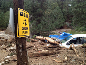
Damage in Jamestown on September 15, 2013. (Boulder OEM)
Damage in Jamestown on September 15, 2013. See the map of rainfall totals from the flooding event below. Click the image to view a photo slideshow of the devastation. (Boulder OEM)

By the numbers, the rainfall experienced across northeastern Colorado since Monday, September 9 has been nothing short of extraordinary.  Over the span of a week, many locations received half of what they normally receive in an entire year.  Some received more than what they expect annually.

We have created and interactive map (below) that shows precipitation totals from Monday, September 9, 2013 to Monday, September 16, 2013.  The numbers are totals as reported by CoCoRaHS volunteers – the Community Collaborative Rain, Hail & Snow Network.

Looking at the map, it is clear that the Boulder area received the most with one station recording an astonishing 21.13” over the 7 day timespan.  The official station in Boulder has recorded 16.69” inches this month and 29.65” for the year. These numbers break Boulder’s monthly record and its annual precipitation record.

Denver’s official station at Denver International Airport (DIA) has recorded 4.65 inches this month, enough to put September 2013 in the books as the 2nd wettest on record.  However, that total hardly reflects what locations closer to the city’s center received with many recording over 7” this month.

Here in Thornton we have seen 8.85” of rain so far this month, an extraordinary total that brings our total for 2013 to 18.81”.  This is clearly the biggest month and year for precipitation since ThorntonWeather.com came online in 2007 and likely the biggest month ever in Thornton.

If you have a hard time viewing the map in the window below, click here to launch a larger version.

  • Don’t miss a thing when it comes to our ever-changing weather! Be sure to ‘like’ us on Facebook, follow us on Twitter and add us to your Google+ circles.