Category Archives: Natural Disasters

In pictures: Colorado’s record-setting September 2013 rains and flooding

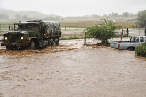
Colorado National Guardsmen respond to floods in Boulder County, Colo., Sept.12, 2013. (Army National Guard Photo by Sgt. Joseph K. VonNida/RELEASED)
Colorado National Guardsmen respond to floods in Boulder County, Colo., Sept.12, 2013. See more images from Colorado’s devastating September 2013 floods in the slideshow below. (Army National Guard Photo by Sgt. Joseph K. VonNida/RELEASED)

September 2013 will forever be etched in the memory of all Coloradans as one which brought amazing destruction – and death.  Images of the truly historical event tell the story of the damage in the aftermath but also show the indomitable human spirit and the willingness of Americans to come together and help in times of need.

Northeastern Colorado has a surprisingly arid climate but also is an environment ripe for extreme weather events like the rain and floods we  experienced.

The cost and final death toll from the floods will be determined in the coming days, weeks and months but we know already this is one for the record books.

The September 2013 event lasted multiple days and effects were felt from the mountains and foothills to the flat eastern plains.  Many locations saw rainfall totals over four days equal to half of what they normally receive in an entire year.

The images in the slideshow below were gathered from a variety of sources.  If you have photos to share, please email them to info@thorntonweather.com and we will add them.

  • Don’t miss a thing when it comes to our ever-changing weather! Be sure to ‘like’ us on Facebook, follow us on Twitter and add us to your Google+ circles.
[flickr_set id=”72157697969563182″]

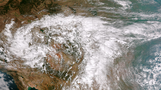
NOAA satellite image captures ‘biblical’ storm as it strikes Colorado

This image from the Suomi NPP satellite's VIIRS sensor from the evening of September 11, 2013, shows the storm system that has devastated towns in the foothills of the Rockies in central Colorado. Flash Flood Watches and Warnings are in effect throughout central Colorado, citing excessive runoff causing flash flooding of creeks and streams, roads and roadside culverts. The heavy rains could also trigger rock slides or debris flows in steep terrain. Major amounts of rain over the last several days have saturated soils in many foothill and Urban Corridor locations and additional rainfall in these locations today and tonight will only exacerbate an already serious situation. The High Park and Four Mile burn areas will be especially susceptible to the heavy rains. This image was taken around 2015Z on September 11, 2013. (NOAA)
This image from the Suomi NPP satellite’s VIIRS sensor from the evening of September 11, 2013, shows the storm system that has devastated towns in the foothills of the Rockies in central Colorado. Flash Flood Watches and Warnings are in effect throughout central Colorado, citing excessive runoff causing flash flooding of creeks and streams, roads and roadside culverts. The heavy rains could also trigger rock slides or debris flows in steep terrain. Major amounts of rain over the last several days have saturated soils in many foothill and Urban Corridor locations and additional rainfall in these locations today and tonight will only exacerbate an already serious situation. The High Park and Four Mile burn areas will be especially susceptible to the heavy rains. This image was taken around 2015Z on September 11, 2013. (NOAA)

* Click the image above for a larger view

Five days of rain, one with absolutely torrential downpours, created dangerous and deadly flooding across much of the Colorado Front Range.  At one point the National Weather Service warned of ‘biblical rainfall amounts’ and it became hard to argue with that terminology.  The rainfall amounts were truly astounding.

Boulder, where some of the worst flooding was seen, recorded 9.08” on Thursday, September 12.  Estes Park, where the Big Thompson River flooded its banks, saw 3.9” over the 24 hour period.

Officially Denver only saw 1.1” on the date but that was as measured at Denver International Airport which only saw the edge of the storms.  At the previous historical location in Stapleton, 3.68” was measured.

Here in Thornton we seemed to be right in line for the storms and generated one of the higher totals in the metro area accumulating 4.76” on the date.  Since the rain started five days ago, we have received an amazing 7.66” (as of this writing).

  • Don’t miss a thing when it comes to our ever-changing weather! Be sure to ‘like’ us on Facebook, follow us on Twitter and add us to your Google+ circles.

Raw video: Colorado’s flooding in Boulder and Estes Park

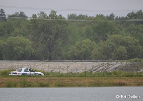
Water flows over the banks of the South Platte River into Sprat-Platte Lake near Thornton on the afternoon of September 12, 2013.   Click for a larger view.  (Ed Dalton)
Water flows over the banks of the South Platte River into Sprat-Platte Lake near Thornton on the afternoon of September 12, 2013. Click for a larger view. (Ed Dalton)

What has been called a 100-year storm and even referred to as being of ‘biblical’ proportions is very slowly coming to an end.  The worst of the rain fell on Thursday, September 12 with locations in Colorado’s foothills reporting in excess of 8 inches of rainfall.

Among the hardest hit areas were the college town of Boulder and picturesque Estes Park.  Both cities have seen extensive flooding and damage totals across the state will be well into the tens, if not hundreds, of millions of dollars.

The two videos below capture the raging waters as they pummeled the communities.

The first video shows Boulder as well as some commentary by Gov. John Hickenlooper.  The second is of downtown Estes Park.

  • Don’t miss a thing when it comes to our ever-changing weather! Be sure to ‘like’ us on Facebook, follow us on Twitter and add us to your Google+ circles.

California’s Rim Fire continues to grow, threatens Bay Area water and Yosemite National Park

Progress battling the massive Rim Fire has been slow to come and while some gains have been made, the blaze continued to grow and now encompasses more than 280 square miles.  The blaze has already intruded on Yosemite National Park and were perilously close to its infamous giant sequoia trees. Park officials were placing sprinklers in two groves of sequoias not far from the fire.

Read more about the Rim Fire and check out the video and photos on Examiner.com

A firefighter uses a hose to douse the flames of the Rim Fire on August 24, 2013 near Groveland, California.
A firefighter uses a hose to douse the flames of the Rim Fire on August 24, 2013 near Groveland, California. (Getty Images) Click the image to view a slideshow from the Rim Fire.

Stunning image captures lightning strike from wildfire’s pyrocumulus cloud

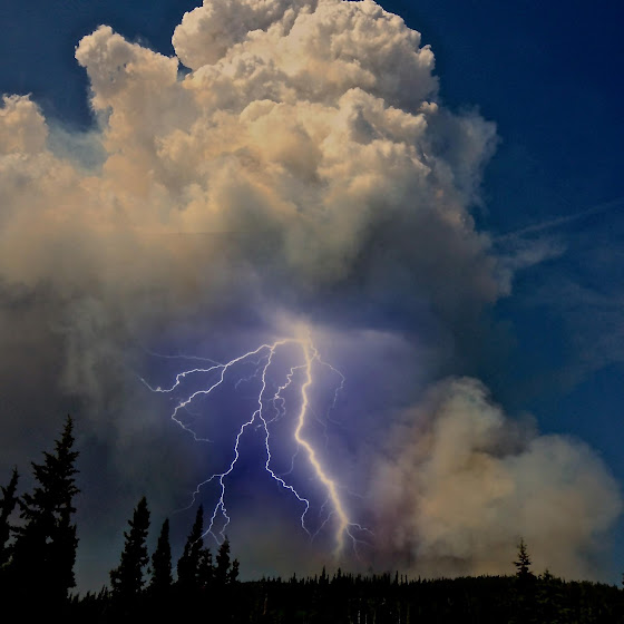
Weather of course clearly affects wildfires but fires themselves can literally create their own weather.  One such phenomena are pyrocumulus clouds and a photo from a wildfire in Alaska provides a stunning example.

Pyrocumulus clouds are formed by fires or volcanos when the intense heat from the event rises from the surface.  These clouds oftentimes look like dirty thunderstorm clouds directly over a blaze and can give rise to thunderstorm-like weather conditions.

Lightning from these clouds can occur and in particular when coupled with a volcanic eruption are absolutely amazing.  With wildfires, the strong winds and lightning can result in dangerous and unpredictable expansion of a fire.

The Moon Lake Complex Fire is currently burning in eastern Alaska and has scorched over 18,000 acres.  Inciweb posted a photo of a pyrocumulus cloud over the blaze near Tok that let loose a stunning bolt of lightning.

June 2, 2013 - A pyrocumulus cloud above the Moon Lake Complex Fire in Alaska unleashes a lightning bolt. (Inciweb)
June 2, 2013 – A pyrocumulus cloud above the Moon Lake Complex Fire in Alaska unleashes a lightning bolt. (Inciweb)

Satellite imagery captures explosion of West Fork Complex Fire, Papoose Fire and thunderstorms

Satellites provide an amazing eye in the sky for monitoring the weather and climate.  Their usefulness today was once again proven as they captures wildfires exploding in Colorado’s southwest and thunderstorms to the northeast.

The satellite imagery animation comes from the NOAA GOES East satellite and was assembled by Colorado State University RAMSDIS.  It covers the period from 1:55pm to 4:40pm on Friday, June 21, 2013.

The tandem West Form Fire and Papoose Fire in southwestern Colorado are seen sending massive smoke plumes into the sky.  Afternoon thunderstorms are exploding in the northeastern corner of the state.

ThorntonWeather.com unveils revamped earthquake pages

Earthquakes occur every year in Colorado and of course daily across the globe.  Our new earthquake pages help you keep an eye on the temblors.
Earthquakes occur every year in Colorado and of course daily across the globe. Our new earthquake pages help you keep an eye on the temblors.

While Colorado isn’t often considered a prime location for earthquakes, temblors can and do occur in the state every year.  Many are in less populous locations but can be damaging.  Our revamped earthquake page(s) help you keep tabs on the rumbling earth.

We revamped our main earthquake page to now include an interactive Google map and realtime list of quakes.  This shows quakes of magnitude 2.0 or greater over the past 7 days within a 500 mile radius of Thornton as reported by the United States Geological Survey (USGS).

Other locations on the globe are certainly more prone to devastating quakes.  To help view these events which occur with startling frequency, we created a global earthquake page.  This shows all magnitude 4.0 temblors within the past 7 days.

Both of these pages are available via the links below or in the almanac menu to the left.

While normally not particularly active, there are approximately 100 potentially active faults in Colorado and more than 400 temblors of magnitude 2.5 have occurred in the state since 1870. The state’s largest quake occurred on November 7, 1882 along the northern Front Range and measured 6.6 on the Richter Scale.

According to the Colorado Division of Emergency Management, the costliest quake was a 5.5 magnitude temblor that occurred on August 9, 1967 and was centered near Commerce City. The quake caused more than $1 million worth of damage and is thought to have been caused by the injection of liquid waste into the earth at the Rocky Mountain Arsenal.

Longtime Denver area residents well remember the shaking that occurred with regularity from the mid-60s through the early 80s due to the activity at the Arsenal.

Drought, floods, Sandy, Bopha among disasters on top 10 climate events for 2012

Disasters claimed thousands of lives in 2012 in the form of floods, earthquakes, tropical storms and tornadoes. This week NOAA released its list of top 10 global weather and climate events and natural disasters took their place in a number of spots.  Drought in North America which we of course have seen here in Colorado makes the list as do many other notable disasters.

Read the rest of this story on Examiner.com.

Australian family shares terrifying story, photos of escape from wildfire

Record-setting heat and tinder dry conditions have brought devastating bushfires to Australia in recent weeks, hitting the island state of Tasmania the hardest. One family’s harrowing escape was captured in terrifying detail with pictures of them fleeing to water to avoid the fast moving flames.  Read the rest of this story on Examiner.com and check out the amazing photos.

Tammy Holmes and her grandchildren seek shelter in the water from devastating wildfires near Dunalley, Tasmania Australia. (Tim Holmes)

Sen. Harry Reid sparks outrage over comparison of Hurricane Sandy to Katrina

Senate Majority Leader Harry Reid’s comment last week that those who suffered the effects of Hurricane Katrina had it easy as compared to the aftermath of Hurricane Sandy has sparked a quick and vicious response. Sen. David Vitter called the Democrat leader ‘an idiot’ Monday and Reid was forced to issue an apology.  Read the rest of this story and see video of Reid’s comments on Examiner.com

Senate Majority Leader Harry Reid (D-NV) rubs his eyes during the counting of the Electorial College votes. Reid's comments minimizing the victims of Hurricane Katrina have sparked outrage. (Getty Images)