Category Archives: Natural Disasters

Ranking the top 10 Colorado weather events of the past 10 years

The March 2003 blizzard that buried Thornton in snow was ranked as the top weather event of the past 10 years. (ThorntonWeather.com)

There is a lot that can be said about the weather in Colorado but ‘boring’ is not usually a term associated with it.  Anyone who has lived in the Centennial State for very long quickly experiences a weather-related event that will give them memories for a lifetime. 

From major snowstorms and blizzards to tornadoes, wildfires, scorching heat and damaging hail storms Colorado weather can and does bring it all to the table.  The Denver office of the National Weather Service has released a list of what local meteorologists rank as the top 10 weather events of the past 10 years.

For some it may be a blizzard that buried the Mile High City in a heavy blanket of snow and brought everything to a standstill.  Others will remember the heavy smoke from fires burning in the mountains destroying hundreds of thousands of acres.  The tragedy tornadoes bring to Colorado in terms of destruction and loss of life may be what others remember.

Over the past 10 years many memorable weather events have occurred that fully display the sheer variety of weather Colorado receives.  A team of meteorologists serving Colorado analyzed these events and ranked them based on meteorological intensity and their human and economic impact.

Continue reading Ranking the top 10 Colorado weather events of the past 10 years

Oregon town struck by rare EF-2 tornado

An EF-2 tornado struck the town of Aumsville, Oregon on Tuesday damaging 50 structures. Click the image for a slideshow of the damage from Examiner.com.

Tornadoes are not usually asssociated with Oregon or December and certainly not the two of them together.  Tuesday however that rarest of event did occur when an EF-2 tornado packing 110+ mph winds struck the town of Aumsville.

The first report of the tornado was at 11:59am PST when emergency personnel reported spotting the twister.  Power was knocked out to thousands and several homes and businesses were damaged or destroyed.  Two minor injuries were reported. 

The National Weather Service completed their preliminary investigation of the twister and rated the tornado as an EF-2 with winds between 110 and 120 mph.  At its maximum the twister was 150 yards wide and carved an intermittent path 5 miles long. 

For more details on the tornado including video and a photo slideshow of the damage, please visit the Natural Disasters Examiner.

Navy “Angels” deliver help for kids in hurricane stricken New Orleans

Blue Angels live up to their name - deliver tons of toys to children. Click the image to view a slideshow. (Examiner.com)

Every child should have a toy under the Christmas tree but the sad reality is that there are those that go without.  In New Orleans, the city is still recovering from Hurricane Katrina and many children have been forced to grow up all too soon and face the reality of a natural disaster.  The U.S. Navy Blue Angels went into action recently to help ensure those kids are not forgotten on Christmas morning. 

This extraordinary story comes our way from the Natural Disasters Examiner:

“Living up to the “angels” part of their name, the U.S. Navy’s flight demonstration team flew their cargo aircraft Fat Albert on a mission of mercy.  Partnering with Lockheed Martin, Toys R Us and other corporate sponsors the group’s actions ensure that the children affected by Hurricane Katrina will not be forgotten this Christmas. 

“Starting from their home base in Pensacola, the gargantuan C-130 Hercules made stops in Atlanta and Dallas to gather up its precious cargo.  The final stop was Naval Air Station Joint Reserve Base New Orleans in Belle Chasse, Louisiana on December 2nd. 

“Over 1,000 toys weighing in at 169,000 pounds were delivered by the sailors and Marines. “

Our U.S. military performs hundreds of good deeds like this each and every day but many go unnoticed so it is nice to see the U.S. Navy get some recognition.  Be sure to read the full story on the Natural Disasters Examiner and click the image above right to view a slideshow of this angelic mission.

2010 Atlantic Hurricane Season as Active as Predicted but U.S. Dodges the Bullet

2010 Atlantic Hurricane Season Track Map
Track map of the 2010 Atlantic hurricane season shows how lucky the U.S. was. Click image for larger version. (NOAA)

Virtually every forecaster predicted an extremely active 2010 hurricane season and they were proven right.  Mercifully however the United States was spared the worst as not one storm made landfall in the U.S.

In all, there were 19 named storms in 2010 which ties 1887 and 1995 for the third most on record.  Of those 19, 12 became hurricanes tying 1968 for the second highest on record.  Five became major hurricanes of Category 3 or greater.  On average the Atlantic sees 11 named storms, six hurricanes and two major hurricanes. 

  • Watch: Scroll down to see video of the 2010 hurricane season as captured by NOAA satellites

Other notable statistics from the season include three periods when there were three named storms occurring at the same time.   On August 30, Hurricane Earl, Hurricane Danielle and Tropical Storm Fiona were all churning.  Two days later it was Tropical Storm Gaston, Tropical Storm Fiona and Hurricane Earl.  Finally on September 14 we saw Hurricane Karl, Hurricane Igor and Hurricane Julia all at once. 

For a 36 day period from August 21 to September 26 there was at least one tropical cyclone active in the Atlantic.  A total of 11 storms were active during that period.  September alone saw eight named storms tying the 2002 and 2007 hurricane seasons. 

On average 25% of Atlantic hurricanes make landfall in the United States.  Given how active the season was, it is that much more remarkable that the U.S. was spared. 

Other places along the Atlantic were not so lucky.  In all, 259 deaths were directly attributed to the hurricane season and more than $11 billion in damage was realized.  Tropical Storm Matthew was the deadliest 2010 storm accounting for 126 fatalities in Nicaragua, Belize and Cuba.   

While the Atlantic was active, the eastern Pacific saw the fewest number of named storms and hurricanes since the satellite era began in the mid-1960s.  Only seven named storms developed of which three became hurricanes.  Two of those three became major hurricanes.  For comparison, the North Pacific averages 15 named storms, nine hurricanes and four major hurricanes.

NOAA Time Lapse Video of the 2010 Atlantic Hurricane Season

Strong cold front brings tornadoes, damaging wind to Illinois and Wisconsin

Path of EF2 tornado in Illinois on November 22, 2010. (NWS)

November is not normally the time of year for tornadoes, least of all in states in northern latitudes like Illinois and Wisconsin.  That however did not stop a mini-outbreak yesterday as at least two tornadoes struck and as many as seven were possible.

  • Watch video of the twister below

Severe thunderstorms were spawned yesterday by a strong cold front moving across the upper Midwest.  The twisters were the first in 26 years to strike the area in November – you have to go all the way back to November 9, 1984 to find the last one.

The National Weather Service has confirmed that the strongest of the tornadoes yesterday was an EF2 packing winds of 135mph.  It covered a path of 16.4 miles and had a maximum width of 200 yards.  The twister overturned a bus, caused significant damage to buildings and injured six people. 

Below you can see a video of the twister as it passed near Loves Park, Illinois.

Surveillance video shows trailers being overturned by tornado

Crews pick up debris from Chickamauga Creek Oct. 27, 2010. (USACE/ Richard Scott)

An extraordinary severe weather outbreak on Tuesday, October 26th brought Mother Nature’s fury to a large part of the nation stretching from Mississippi to Michigan.  Of the dozens of tornadoes reported that day, one ripped through Chickamauga Lock near Chattanooga, Tennessee and was captured on surveillance video.

  • Watch the amazing video below

The twister ripped through an area near Chickamauga Dam Tuesday evening where the Army Corps of Engineers is constructing the lock.  No injuries to the employees working at the sight were reported but the Corps said some barely escaped. 

The video, captured by a surveillance camera, initially gives no indication of the destruction that is about to come as conditions appear calm and vehicles are seen driving on a nearby road.  40 seconds into the video the winds and rain begin to pick up and 10 seconds later two construction trailers are flipped over and reduced to rubble.

Wayne Huddleston, project manager at Chickamauga Lock, said “The Corps is relocating personnel to other buildings on site and repairs and cleanup are ongoing.  We are extremely pleased that no people were hurt and that operations were not seriously affected by the storm.”

The video clearly shows why mobile homes and other structures without permanent foundations are never a safe place to take cover during severe weather.  Residents should always seek sturdier shelter in a permanent structure.

For all the latest on all types of natural disasters, be sure to check out the Natural Disasters Examiner.

Dual disasters strike Indonesia killing hundreds

Indonesia's Mount Merapi erupted multiple=
Indonesia's Mount Merapi erupted multiple times in the past week even as the nation is recovering from a tsunami. View photos of the eruption in the slideshow below.

One major natural disaster is bad enough but the nation of Indonesia is struggling to recover from two that struck in the past week.  A major earthquake caused a tsunami late Monday and Tuesday the nation’s most active volcano erupted.

Off the nation’s western coast, a magnitude 7.7 earthquake triggered a tsunami with 10 foot waves on Monday.  Villages on the islands of Pagai and Silabu were destroyed and the death toll from that event stands at more than 400 with nearly 200 still missing.

Mount Merapi, located on the main island of Java, erupted on Tuesday and has since had two more eruptions.  The latest, which occurred today, claimed one life bringing the total death toll from that disaster to 36.

Evacuations had been issued prior to the first eruption however many ignored the warnings.  Further, after the initial blast, many residents returned home only to find themselves in danger from subsequent eruptions. 

View the slideshow below for images from the erupting volcano and the aftermath. For complete coverage of the tsunami and volcano -and all forms of natural disasters – please visit the Natural Disasters Examiner.

Photo slideshow of Mount Merapi eruption. (Examiner.com)More on Mount Merapi from the Global Volcanism Project:

Merapi, one of Indonesia’s most active volcanoes, lies in one of the world’s most densely populated areas and dominates the landscape immediately north of the major city of Yogyakarta. Merapi is the youngest and southernmost of a volcanic chain extending NNW to Ungaran volcano.

Growth of Old Merapi volcano beginning during the Pleistocene ended with major edifice collapse perhaps about 2000 years ago, leaving a large arcuate scarp cutting the eroded older Batulawang volcano. Subsequently growth of the steep-sided Young Merapi edifice, its upper part unvegetated due to frequent eruptive activity, began SW of the earlier collapse scarp.

Pyroclastic flows and lahars accompanying growth and collapse of the steep-sided active summit lava dome have devastated cultivated lands on the volcano’s western-to-southern flanks and caused many fatalities during historical time. The volcano is the object of extensive monitoring efforts by the Merapi Volcano Observatory.

Tornado chasing becomes new vacation of choice for thrillseekers

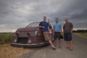
"Tornado tourism" is becoming a quickly growing industry as folks look for alternatives to a trip to the beach. (ThorntonWeather.com)
"Tornado tourism" is becoming a quickly growing industry as folks look for alternatives to a trip to the beach. Check out the slideshow below to see what a one week tour yielded this past summer. (ThorntonWeather.com)

While many might view a tornado something to flee from, an increasing number of vacationers are flocking to the Great Plains for the chance to get up close and personal with a twister.  A new study shows that storm chasing tours are becoming a vacation of choice for not only many Americans but also visitors from overseas. 

A University of Missouri research team found that interest in tornado chasing is being fed by popular television shows like the Discovery Channel’s Storm Chasers.  Further, thanks to the power of the Internet, live video streams by storm chasers showing tornadoes as they rip across the landscape have skyrocketed in popularity. 

Tornado Alley stretches across the nation’s midsection and is a unique location as most of the world’s tornadoes occur in this broad swath from South Dakota to Texas.  Tour operators like Silver Lining Tours have capitalized on tourists seeking something more adventurous than a day at the beach.  

Researchers Sonja Wilhelm Stanis and Carla Barbieri said that while the majority of participants in these tours were American, there was an international flavor to them as well. “While more than half of the surveyed travelers lived in North America, 11 percent came from Australia and nearly a third traveled from Europe to get a close encounter with a tornado.”

Storm chasing tours take to the Great Plains on the hunt for tonradoes. This past summer as part of our work with Examiner.com, we rode along on a seven day tornado chasing tour that covered more than 3,000 miles.  Among the 18 tourists were five British citizens, three of whom have been on multiple storm chasing tours in the United States. 

Demographics for the group ran the entire gamut from married couples to singles aged from 25 to 55.  Their backgrounds were as varied as one would expect at any vacation destination with blue collar workers and urban professionals all among the participants. 

The study found that most that chose this high-risk activity were satisfied with the experience, even if they did not see a tornado.  One-third of them saw a tornado while 50% saw funnel clouds.  The vast majority, 95%, at least saw a “significant atmospheric event.” 

View the slideshow for images of what it is like on a storm chasing tour.  Also be sure to check out this video shot by ThorntonWeather.com of the Campo, Colorado tornado.

Related stories:

Are you ready for Storm Chasers? Season premiere of Discovery Channel show nears

The Dominator team led by Reed Timmer are one of three groups of chasers in this season of Storm Chasers. (Discovery Channel)

Every spring and summer storm chasers take to the Great Plains on a single-minded quest to experience a tornado up close and personal.  While many people may find this odd, the cast of the Discovery Channel series Storm Chasers relishes the annual ritual and the channel is set to kick off the fourth season of the hit series.

The 1996 movie Twister brought storm chasing on to the big screen and to the forefront of the public consciousness.  On the small screen, Storm Chasers has become one of the most popular shows on Discovery Channel as camera crews follow teams of professional chasers hunting tornadoes. Both have been responsible for the increasing interest in “tornado tourism” during severe weather season

For the 2010 season the show sees the return of familiar faces for those that have seen the show before but also a notable one appears to be missing. 

Get all the details including a video sneak peak at the upcoming season on the Natural Disasters Examiner – it looks to be an exciting season!

Space station astronaut captures images of Hurricane Igor and Hurricane Julia

Hurricane Igor is scene in this view from the International Space Station.  See more images in the slideshow below.
Hurricane Igor is scene in this view from the International Space Station. See more images in the slideshow below.

A truly rare event is occurring in the Atlantic Ocean where for the first time in 84 years two Category 4 hurricanes are churning at the same time. Yesterday astronaut Douglas Wheelcock snapped stunning images of Hurricane Igor and Hurricane Julia from his perch 220 miles above the Earth aboard the International Space Station.

  • View the pictures in the slideshow below

Anthony Watts of the popular website Watts Up With That? determined that only three times in the past have two major hurricanes (defined as Category 3 or higher) occurred at the same time.

Given that Igor and Julia are now both Category 4 storms with 135 mph winds, two storms of that strength occurring simultaneously has only happened once – on September 26, 1926.

Of greatest immediate concern is Hurricane Igor. The storm is currently 540 miles east-northeast of St. Martin and appears to be headed for a direct strike on Bermuda sometime Sunday night.

Hurricane Julia is much farther east, approximately 500 miles west of the Cape Verde islands. Julia’s forecast path has her turning to the north and, hopefully, not presenting a danger to land.

The Expedition 24 crew on board the International Space Station includes West Point graduate and Army colonel Douglas Wheelcock. During his time on board the ISS, Wheelcock has captured some astounding images and posted them to Twitter, including photos of Hurricane Earl two weeks ago.

The new images posted today were snapped over the past 24 hours as the ISS passed over the storms. The image of Hurricane Igor is arguably the most impressive as it provides a clear view vertically down into and through the eye of the storm.

The slideshow below from the Natural Disasters Examiner contains the images taken by Colonel Wheelcock as well as images of previous hurricanes taken by International Space Station and Space Shuttle crews and NASA satellites.

Hurricanes from space - Nature's fury seen from on high