Category Archives: Thornton Weather

Denver breaks 107 year old record

Denver officially broke the record for the coldest temperature recorded on this date.

Updated 12/15/08 @ 3:30am:

It’s officially cold as heck now!  The cold front has caused the mercury to plummet across the Front Range and we have officially set two new low temperature records.

At 5:52pm on Sunday, December 14th, the temperature at Denver International Airport dropped to -15 degrees.  That broke the old record of -14 degrees for this date set way back in 1901.  The mercury continued to drop and bottomed out at -18 degrees at 6:35pm.

The morning of the 15th has started with a new record low temperature as well.  At 12:00am the temperature was -13 degrees, breaking the old record for the date of -6 set in 1951.  The temperature is still dropping so that record will undoubtedly get even colder. 

It is important to note that prior to DIA opening, temperatures were measured at the old Stapleton site and prior to 1950 they were measured downtown.   That makes a 15 mile distance between where temperatures are measured now and where they were prior to March 1995.  Those 15 miles can accont for large differences in temperature so the record setting temperatures needs to be balanced with that knowledge as in some ways you are comparing apples and oranges.  Click here for a bit of history on the Denver Forecast Office.

Original posting:

We can officially say it is cold now.  The National Weather Service has reported that at 5:52pm the temperature at Denver International Airport dropped to -15 degrees.  That breaks the old record of -14 degrees for this date set way back in 1901. 

Thankfully here in Thornton we haven’t gotten that cold.  At 7:00pm Sunday night it is currently -6.2 degrees.  We will get down to -11 tonight and then only climb to 18 Monday.  Bundle up!

It is important to note that prior to DIA opening, temperatures were measured at the old Stapleton site (and before that downtown).   That makes a 15 mile distance between where temperatures are measured now and where they were prior to 1994.  Those 15 miles can accont for large differences in temperature so you have to take these new records with a grain of salt.

The snow is ending but the arctic cold will remain

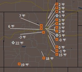
The Rocky Mountain Weather Network is showing temperatures barely above zero across Denver as of 10:00am Sunday morning.

Last night and this morning the metro area received a nice little bit of snow, something which was desperately needed. The northern and western suburbs received more than the rest of the metro area. Areas like Thornton and Broomfield are reporting around 4 inches while Centennial and Parker are just a bit more than an inch. Officially, the National Weather Service reported 1.3 inches at the old Stapleton International Airport site.

The big story though isn’t the snow – it is the frigid cold that is accompanying it. Denver International Airport has reported temperatures as low as 3 degrees below zero and the wind chills are into the negative teens. Currently stations on the Rocky Mountain Weather Network are reporting low single digit temperatures across the Front Range.

Today most of the metro area will remain in the single digits with Denver reaching a high of around 9 degrees. Tonight will be equally frigid and drop to 2 below zero. There will be some minor warming during the work week but it won’t be much and it will be the latter half of the week before we see temperatures above freezing. A chance for snow will also remain each day and night with the best chance being Monday night into Tuesday morning.

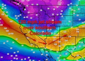
120 mph jet stream is sitting over southern Colorado and bringing the cold air down from the north.

This cold air is being drawn down by a rather powerful jet stream that has set in over the southern part of Colorado. Areas to our north in Wyoming, Montana and the Dakotas have it much worse than us – Spearfish, SD recorded -13 degrees with a -22 degree wind chill this morning!

With the severe cold and the snow, now might be good time to take a look at our Winter Weather Preparedness series:

Part 1 Winter travel safety
Part 2 Watches…warnings…and advisories
Part 3 High winds
Part 4 Wind chill temperatures and hypothermia
Part 5  Avalanche safety
Review  Winter Weather Preparedness Week review

Weather gifts for the weather geek in your life

ThorntonWeather.com has some great ideas for Santa Claus for the weather enthusiasts he may be bringing gifts to.

Is there someone on your shopping list that looks out at a blizzard with glee on his or her face?  Someone who jumps and runs to the window at hearing thunder or seeing the flash of lightning?  Maybe a person for whom the weather warning beep on the TV or radio is music to their ears?  Well then this posting is for you.  Here are some great gift ideas for the weather geek on your list.  If you have any questions about any of these, leave a comment and we will answer them.  Also be sure to check out our list of great places to shop for weather gifts.

Books – There are books about every type of weather condition out there.  We recently wrote about some of our top picks for weather related books for grownups and adults.  Click here for some specific ideas

  • Cost:  $10.00 and up
  • Where to buy:  Amazon.com

Storm Chasing and Weather Clothing – Any proud weather geek will be happy to not only tell someone about their hobby but also to wear it!  Shirts and clothing with tornadoes, hurricanes or even ones that proclaim the wearer as a “Weather Geek” or “Weather Diva” are a big hit.  Kids love the stuff too.

Weather Radios – You don’t have to be a weather enthusiast to appreciate or need a weather radio – these are great gifts for anyone.  These radios are relatively inexpensive and allow you to listen to and monitor the NOAA Weather Radio All Hazards (NWR) system. NWR broadcasts official Weather Service warnings, watches, and forecasts as well as other hazard information like earthquakes, avalanches, chemical spills, and even AMBER alerts.  Be sure to get one with SAME coding so it automatically turns on when something is happening in your area.

Emergency Kits – Most folks interested in severe weather are also quite likely a bit survivalist by nature.  They know the dangers that the weather presents and want to be prepared for it.  An emergency kit for the house or car are not only practical but potentially life saving. 

GPS Systems – Handheld GPS systems like those from Garmin and Magellan are a must have for any storm chaser.  Models can be had for less than $100 for a basic unit to $600 for ones with 3D mapping capability.  Spend the extra money to get one with at least basic, non-3D mapping capability. 

  • Cost:  $100 and up.  Look to spend between $200 and $300 to get a good one with mapping. 
  • Where to buy:  NewEgg or GPS City

Binoculars – Low tech but effective.  You don’t want to get too close to the action and binoculars are a great way to see things from a distance.  You’ll want to look for ones that allow plenty of light in but also aren’t so big the user can’t make a run for it if needed.

Personal Weather Stations (PWS) – Amateur meteorology is a surprisingly popular hobby as you will learn if you take a look.  A basic $50 station will provide outdoor temperature and humidity.  Stepping up a notch to one for around $200 will get you all that plus wind and the ability to hook it up to a computer to archive statistics and create your own weather website like ThorntonWeather.com.  $450+ gets a Davis Instruments weather station which is considered about the best an amateur can buy.
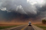
Digital Cameras and Camcorders – Pictures and video help to capture the weather conditions as they happen and make for lasting memories.  With either of them, ones with powerful zoom lenses are a must in order to capture far away action (you don’t want to get too close to a tornado!).  Don’t skimp on quality.

  • Cost:  $400+ for a good one.
  • Where to buy:  NewEgg or Amazon

Storm Chasing Vacation – For a weather geek, what could be better than spending a week on the Great Plains hunting down hail storms, supercell thunderstorms and of course tornadoes!  Storm chasing as a hobby is growing by leaps and bounds and there are many tour operators that seek to fulfill the dreams of those that want to see extreme weather. This is the ultimate gift!  Are you listening to me, Santa?

For more info: Do you have any questions about specific items your weather enthusiast might want or questions about any of the above ideas?  Post a comment and we’ll do our best to answer!

Snowstorm departs and a rough rush hour ensues

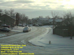
The view from ThorntonWeather.com's east facing webcam at 8:40am.

The snow began tapering off pretty early this morning but not until after it left 4 to 8 inches of the white stuff across much of the metro area.  ThorntonWeather.com recorded 4.4 inches but that probably was a bit more – it was just tough to measure as the wind and blown it all over the place.  We had some spots with an inch and others with a foot.  Thornton seemed to do a good job clearing the major streets but of course residential and side streets were pretty slick. 

Today we’ll warm up to just above freezing at 33 degrees and Wednesday is looking very nice reaching near 50 degrees.  Thursday there is a slight chance of snow but we are really keeping our eye on the period between Saturday and Monday as there is greater potential there for more snow.  Stay tuned.

In the meantime, here are some of the storm reports from across the region:

07:00 AM   12/09/2008    REPORTED BY: TRAINED SPOTTER
BOULDER COUNTY, CO   –  1 MILE NORTHWEST OF NIWOT
SNOW  MEASURED AT 3.9 INCH    
 
07:00 AM   12/09/2008    REPORTED BY: TRAINED SPOTTER
GILPIN COUNTY, CO   –  3 MILES NORTH OF BLACK HAWK
HEAVY SNOW  MEASURED AT 6.2 INCH    
 
06:48 AM   12/09/2008    REPORTED BY: TRAINED SPOTTER
JEFFERSON COUNTY, CO   –   GENESEE
HEAVY SNOW  MEASURED AT 12.0 INCH    
 
06:30 AM   12/09/2008    REPORTED BY: TRAINED SPOTTER
DOUGLAS COUNTY, CO   –  2 MILES WEST OF PARKER
HEAVY SNOW  MEASURED AT 7.0 INCH    
 
06:20 AM   12/09/2008    REPORTED BY: TRAINED SPOTTER
JEFFERSON COUNTY, CO   –  1 MILE SOUTHWEST OF EVERGREEN
HEAVY SNOW  MEASURED AT 6.0 INCH    
 
06:15 AM   12/09/2008    REPORTED BY: TRAINED SPOTTER
PARK COUNTY, CO   –  3 MILES NORTH OF BAILEY
SNOW  MEASURED AT 2.5 INCH   TOP OF CROW HILL
 
06:09 AM   12/09/2008    REPORTED BY: TRAINED SPOTTER
DOUGLAS COUNTY, CO   –   ESE CASTLE PINES
SNOW  MEASURED AT 5.0 INCH    
 
06:00 AM   12/09/2008    REPORTED BY: TRAINED SPOTTER
BOULDER COUNTY, CO   –  2 MILES WEST OF BOULDER
HEAVY SNOW  MEASURED AT 9.1 INCH    
 
05:52 AM   12/09/2008    REPORTED BY: TRAINED SPOTTER
CLEAR CREEK COUNTY, CO   –  6 MILES SOUTHWEST OF EVERGREEN
HEAVY SNOW  MEASURED AT 10.0 INCH    
 
05:50 AM   12/09/2008    REPORTED BY: TRAINED SPOTTER
DOUGLAS COUNTY, CO   –  4 MILES EAST OF PARKER
SNOW  MEASURED AT 5.8 INCH    
 
05:38 AM   12/09/2008    REPORTED BY: TRAINED SPOTTER
ADAMS COUNTY, CO   –   6 MILES NORTHEAST OF THORNTON
SNOW  MEASURED AT 4.8 INCH    
 
05:30 AM   12/09/2008    REPORTED BY: TRAINED SPOTTER
DENVER COUNTY, CO   –  DENVER
SNOW  MEASURED AT 5.6 INCH    
 
05:22 AM   12/09/2008    REPORTED BY: TRAINED SPOTTER
ARAPAHOE COUNTY, CO   –  12 MILES SOUTHEAST OF AURORA
HEAVY SNOW  MEASURED AT 6.2 INCH    
 
05:15 AM   12/09/2008    REPORTED BY: TRAINED SPOTTER
ADAMS COUNTY, CO   –   4 MILES NORTHEAST OF THORNTON
SNOW  MEASURED AT 4.4 INCH    
 
04:30 AM   12/09/2008    REPORTED BY: AMATEUR RADIO
BOULDER COUNTY, CO   –   LOUISVILLE
HEAVY SNOW  MEASURED AT 8.7 INCH    
 
04:20 AM   12/09/2008    REPORTED BY: NWS EMPLOYEE
BOULDER COUNTY, CO   –  1 MILE WEST OF BOULDER
HEAVY SNOW  MEASURED AT 8.0 INCH   NWS OFFICE
 
03:15 AM   12/09/2008    REPORTED BY: NWS EMPLOYEE
WELD COUNTY, CO   –  1 MILE SOUTHEAST OF FREDERICK
SNOW  MEASURED AT 3.8 INCH    
 
03:00 AM   12/09/2008    REPORTED BY: CO-OP OBSERVER
LARIMER COUNTY, CO   –  4 MILES EAST OF FORT COLLINS
SNOW  MEASURED AT 0.8 INCH    
 
01:30 AM   12/09/2008    REPORTED BY: TRAINED SPOTTER
PARK COUNTY, CO   –   N FAIRPLAY
SNOW  MEASURED AT 3.0 INCH    

Where to shop for gifts for weather enthusiasts

The tornado warning logo is one of many from Weather Geek Stuff that is available on everything from clothing to cups.

So do you have someone on your Christmas shopping list that simply must know what temperature it is, no matter where they are or what time it is?  Here are some great places to look for gifts for them:

Weather Geek Stuff – Looking for something with a bit of humor to it?  Weather Geek Stuff is a great place for shirts, cups and novelties with a variety of “weather geek” logos.  They have items with their “Weather Geek” and “Weather Diva” logos and some very amusing weather warning sign logo merchandise that are sure to be a hit.

Galileo Shop – The Galileo thermometer – or thermoscope – was invented by Galileo Galilei in the early 1600s.  These glass tubes filled with water use floating spheres to tell the temperature based on Galileo’s specific density principle.  They are beautiful to look at in addition to be a fascinating experiment.  Galileo Shop has tons of different types and styles to choose from.

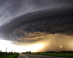
One of the many incredible images available in print from Extreme Instability.

Extreme Instability – Storm chaser Mike Hollingshead has a knack for capturing some of the most incredible images of severe weather you have ever seen.  From tornadoes to wall clouds to lightning, his images are striking to say the least.  On his website you can order prints of his best photos.  

Ambient Weather – This company is known amongst personal weather station owners as being one of the best not only in terms of prices but also customer service.  They carry every type of weather station from basic wireless outside temperature monitors to professional level weather stations. 

Amazon.com – Amazon carries everything from books to bread makers and they have plenty of weather related items.  Books, DVD’s, weather radios and more are all available in this one stop shop.  Not sure what book to buy?  We have you covered there with a guide to some of our favorites – even some for kids.

Continuing snow sure to cause a rough afternoon commute

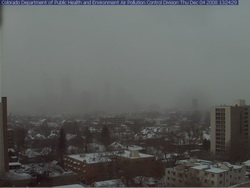
Where's Denver?  This webcam view from the Colorado Department of Public Health and Environment shows Denver obscured in the snowfall at 1:00pm Thursday.
Where's Denver? This webcam view from the Colorado Department of Public Health and Environment shows Denver obscured in the snowfall at 1:00pm Thursday.

If you can, get out of work early today as the roads are sure to be a mess during rush hour.  Snow has been falling across the Front Range all day and snow totals for the metro area are in the 2 to 4 inch range.  Probably just as notable is the bitter cold we are seeing – at 1:00pm DIA was showing 17 degrees and a wind chill of only 2 degrees.  Denver’s high temperature today will most likely be 22 degrees but that was reached at 1:00am!  The wind will continue to keep the wind chills down around zero so bundle up if you head out.

The snow will continue through 11:00pm although accumulations will be pretty light.  The north, west and southern suburbs could see up to 6 inches of snow while the central metro area will end up with around 2 to 4 inches.  Areas of Larimer and Weld Counties including Fort Collins and Greeley will see between 5 to 10 inches of snow. 

A Winter Weather Advisory is in effect for the I-25 corridor north of Longmont as well as most of the central and northern mountains areas.  The extreme eastern portions of the state are under an advisory as well.  In the mountains, eastbound I-70 has chain restrictions in place at the Eisenhower Tunnel, Loveland Pass and at Vail.

Tonight we will dip into the single digits but Friday brings us back into the 40’s and the weekend looks great.

A snowy and slick commute for Thursday

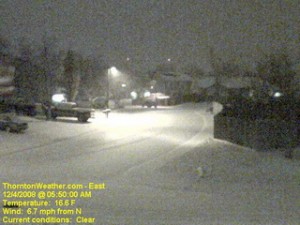
The scene at ThorntonWeather.com at 5:50am today.  Click the image for a current weather webcam view.
The scene at ThorntonWeather.com at 5:50am today. Click the image for a current weather webcam view.

The snow arrived overnight and as of 5:00am ThorntonWeather.com had measured 1.3” and it was still coming down pretty good.  Due to the extreme cold – 17 degrees and a windchill of 5 degrees as of this writing – the roads are quite slick.  This morning we found residential streets to be the worst of course but main arterials like 120th Ave were not in too good of shape either.  Please allow plenty of time to get the kids to school and yourselves to work, allow plenty of distance between you and other cars and just take your time. 

A surge of cold air from the north is expected to intensify the snowfall in the coming hours and a bit of upslope will keep the flakes falling for most of the day.  Accumulations though won’t be all that great – look for 2 to 4 inches overall.  Snow will taper off this evening from the north to the south and completely end in the metro area around midnight.

Friday and this weekend are shaping up great but that could be short lived.  We are watching a cold front coming from Montana that could bring more cold and snow toward the first part of next week.

Snow finally comes to the Front Range

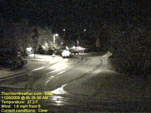
An early morning image from the ThorntonWeather.com east webcam.  Click for larger view.
An early morning image from the ThorntonWeather.com east webcam. Click for larger view.

With only two days to go in the month, things were pretty bleak and we were dangerously close to joining the “top 10” for the least snowiest Novembers in Denver.  That changed in pretty short order last night.  Forecasters were expecting about an inch of snow but the local storm reports indicate most areas exceeded that handily. 

Here in Thornton we started with a touch of rain in the evening which changed to snow as time went on and the temperature dropped.  In the end we recorded 4.1″ of the white stuff, most of which fell between 10:00pm and midnight. 

The National Weather Service in Denver is officially showing 2.4″ of snow at the old Stapleton International Airport site.  At Denver International Airport they recorded 1.6″. 

Some of the other snow reports that have come in (Updated @ 11:15am):

  • Arvada – 2.4″
  • Brighton – 1.5″
  • Conifer – 2.5″
  • Denver (north) – 1.5″
  • Denver (Stapleton) – 3.2″
  • Denver (DIA) – 1.7″
  • Elizabeth – 3.2″
  • Evergreen – 3.2″
  • Erie – 4.5″
  • Highlands Ranch – 3.0″
  • Henderson – 3.0″
  • Highlands Ranch – 4.5″
  • Lakewood – 3.8″
  • Lone Tree – 3.2″
  • Parker – 1.8″
  • Thornton – 4.1″
  • Westminster – 2.2″

For other totals, please see our local storm reports page.

December weather preview – What to expect

December weather preview - what can we expect in Denver?

December brings with it the official start to winter and at the same time we find ourselves hoping we get moisture in the near future. As of this writing, the mountain snowpack in all basins are well below normal, with some as low as 27% of normal. Here in town our our annual snowfall is well below normal as well. In Colorado the snow season starts on July 1st and between that date and November 30th, Denver averages 16.9 inches of snow. Thus far, ThorntonWeather.com has measured a meager 0.2 inch and the official total for Denver taken at the site of the old Stapleton International Aiport stands at 0.8 inch!

So what can we expect in the coming month?  Click here to read our December 2008 climate and weather preview to find out!

City of Thornton launches Thornton Connected

For those that may not have noticed it in the most recent issue of Inside Thornton, the city has launched a new service called Thornton Connected.  This new website and system allows area residents access to all sorts of new information from the city.  First is a Frequently Asked Questions (FAQ) section of the website that covers the entire breadth of city services.  That same information is also available by phone.  Second is an email subscription service that allows area residents to receive periodic emails from the city on a range of topics from just about every city department. 

We have subscribed to many of the email newsletters and have them to be very informative.  The city is also doing a great job of ensuring the number of messages isn’t overwhelming and is only sending out the important stuff.  We commend the City of Thornton on this new service for residents! 

At the current time the system is only for non-emergency messages.  We do wish and hope the city will consider expanding the system to include emergency messages such as tornado warnings, Amber Alerts and other emergency alerts.  The city does not have an emergency siren system or any other way to disseminate emergency information to residents and we believe this would be a valuable and potentially life saving service.  A number of municipalities across the country and in Colorado have implemented such systems.  We are going to talk to the city about this and will update you when we learn more about their plans. 

You can learn more about Thornton Connected on the city’s website or by going directly to http://connected.cityofthornton.net.  As we mentioned, the winter issue of Inside Thornton also has information on the service.  You can download the issue by clicking here – page 10 and 11 have the Thornton Connected information.