Category Archives: Thornton Weather

16 days with 90+ degrees, the record certain to be broken

As on Monday, Denver has seen 16 consecutive days with 90 degrees or higher temperatures.  There was some hope the streak might be broken today but that quickly vaporized as we reached 95 degrees.

The current streak moves into a tie for fourth (with 2000).  The record of 18 days consecutive set in 1901 and 1874 is looking to be sure to be broken before the heat eases.  The next couple of days will see us remain in the mid 90’s and by Thursday and Friday we will be in the upper 90’s (possibly 100).  The weekend shows no relief with temps well into the 90’s as well.  At the current time it looks like we will thouroughly eclipse the 18 day record and there is no end in sight at this time.

Click here to view the updated statistics about our current streak and historical streaks.

August Preview – Summer coming to an end

August 2008 Weather PreviewAs summer vacations wind down and families prepare to send kids back to school in August, Colorado weather also starts to settle down.  The chances for severe weather decrease markedly during August and by the end of the month daytime temperatures are dropping quite a bit as well.  For more information on what to expect in August, click here to view our August 2008 Preview.

Editor’s note:  Somehow we forgot to post the July 2008 preview last month and we apologize for our error.  Should you wish to read it, it is posted here.

12 days and counting – the 90 degree streak continues

The 90 degree streak continues.As of today, Thursday, we are at 12 consecutive days with 90 plus degrees.  Unfortunately there doesn’t appear to be an end in sight although some coming days may drop just below the 90 degree mark.

Friday we can expect 91 degrees, Saturday 93, and Sunday 94.  Monday is currently looking to be around 90 so maybe the streak will end then – keep your fingers crossed! Continue reading 12 days and counting – the 90 degree streak continues

What are those zones?

National Weather ServiceRecently we were asked what are the “zones” that the National Weather Service uses and what is their purpose. This is a very good question.

The National Weather Service in Boulder breaks down Colorado (and other states) into various zones for use when issuing forecasts, watches, warnings, etc. If you look at the text of these, you will see something like this:

SHORT TERM FORECAST
NATIONAL WEATHER SERVICE DENVER CO
1125 AM MDT MON JUL 07 2008

COZ040-041-043-045-071930-

Notice the part in bold. That tells you which zones are affected by the warning – in this case, the CO of course means Colorado.  The “Z” part tells you zones 40, 41, 43 and 45 are affected. So what zone do you live in? In general, if you are in the Denver metro area, you are in either zone 39 or zone 40. You can click here for a PDF map of all Colorado zones.

Sentinel revisits 1981 Thornton tornado

On June 3, 1981 a tornado struck Thornton in what is the worst twister to have struck the Denver metro area. Image courtesy the City of Thornton archives.

I always tell the story of me being in 6th grade at Hillcrest Elementary in Northglenn on June 3, 1981.  Sitting at our desks the principal comes over the intercom and announces that all students need to get under their desks.  I look outside and see that it is dark as night – at least it seemed to be to a scared 12 year old! 

Not long after, a tornado touched down a few miles away along Washington Street in Thornton destroying 25 homes and injuring 53 people. 

In a recent series on the history of Washington Street, the Northglenn-Thornton Sentinel revisited that day and the damage the tornado caused.  It is fascinating reading whether you have lived here long enough to remember it or not. 

Click here to read the article (3MB PDF). 

The heat is on, the fire danger is high!

As we head into the hot days of summer, the lack of moisture begins to drive the fire danger up. Tuesday we are expecting highs temperatures to reach 93 in the Denver metro area before a brief cool down begins but by Saturday those temps will be back up to the mid-90’s.

Much of the western slope once again finds itself under Red Flag Warnings. Frisco in Summit County and Guffey in Park County have recently battled small blazes. With the long holiday weekend approaching, lots of folks will be heading to the high country. More people means there is a greater chance for fire so everyone should be careful.

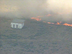
A grass fire burns near Wiggins, CO.Closer to the Front Range, while we are not currently under any fire related advisories, we are still very dry and the danger exists. Just yesterday a grass fire near Wiggins quickly blew up and consumed 2,500 acres and took six hours to contain.

Please be aware of the danger and leave the fireworks to the pros! Remember that fireworks are illegal in Thornton and can get you a $1,000 fine if you are caught using them.

Back from vacation and storms on the plains!

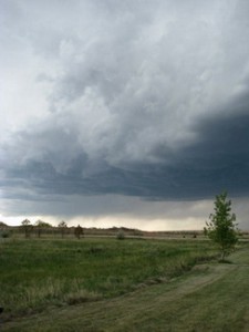
The storm approaches!Your intrepid Weather Examiner is back from vacation, relaxed, tanned and ready for summer!  What makes a good vacation for a weather geek?  Severe storms of course and I saw a doosy while in northeastern Colorado last week. 

Weatherwise my vacation started out pretty boring with mild days, cool nights and I suppose what most people would consider beautiful weather.  Last Friday started out much the same as the week with a calm, beautiful day on the eastern plains of Colorado but it is after all severe weather season and the chances of something brewing over a week are pretty good. 

By the mid-afternoon, more clouds started to roll in and by late afternoon, I was watching a storm cell with great potential develop to the northwest of me.  Soon the weather radio was beeping warning of a Severe Thunderstorm Watch being issued for my location and that was upgraded to a Warning before too long. 
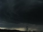
Now we\'re talking!  Getting dark at 5:00 in the afternoon!Soon those clouds started to darken and spots of green were showing – sure signs of something major brewing.  A band of rain was clearly visible and moving our way.  A quick check of the weather radar software on my laptop showed great potential with the cloud tops exploding over 30,000 feet above.  Before long the rain started mixed with a touch of pea sized hail.  That rain got pretty heavy and the wind was getting pretty vicious.

Even a junior weather forecaster can tell there is trouble on the radar!Being in an RV in severe weather is not always the wisest place but I was pretty confident we were okay although we did have a plan to escape to more secure shelter about 75 yards away. After dumping a good inch of rain in less than 20 minutes the storm passes. However, that same storm cell did spawn a tornado 10 miles to the southeast after it passed me. Even more notably, the cell was so powerful, it continued churning out severe weather for an additional 90+ miles before disappating!  
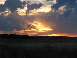
 
After the storm - a beauful sunset on the plains.In the end, having the one day of severe weather while on vacation made it pretty danged fun!  The desire to chase the storm cell was strong but my better half would probably not have approved me leaving the family behind at that point.  🙂

Area King Soopers Offers Discounted Weather Radio

All Hazards NOAA Weather RadioWe recently wrote about systems which provide severe weather alerts to the general public.  In writing that, we extolled the virtues of having a “weather radio” – a specialty radio that allows you to listen to and monitor the NOAA Weather Radio All Hazards (NWR) system.

Midland WR-100 Weather RadioWe just read on KMGH channel 7’s website that all Front Range area King Soopers are offering a very good deal on a Midland WR-100 radio.  These are similar to the WR-300 model we discussed previously – just with fewer bells and whistles.  The WR-100 retails for $49.99 but through September at area King Soopers stores you can buy one for $29.99. 

You can find more information on channel 7’s website including a list of area King Soopers stores and even a video that walks you through how to set the radio up.  This is a great deal and we would encourage everyone to take advantage of it. 

Beautiful Weekend Ahead

Beautiful weekend ahead.Now this is just about perfect!  The forecast shows just about ideal weather if maybe a touch warm.  Friday we will have a high temperature of 82 under clear skies.  Saturday will be the warmest day of the weekend hitting near 90, again under clear skies.  Sunday follows up with a high of 85 with a few clouds around. 

The first part to the middle of next week could see a slight change as a series of cold fronts moves across eastern Colorado.  Afternoon and evening thunderstorms could be a possibility. 

Get outside and enjoy this weather! 

Colorado Weather – Rain, Thunderstorms and Snow – All Today!

One thing that is consistent about Colorado weather is how inconsistent it can be!  Yesterday evening we saw some metro area thunderstorms with some rain and a pretty good lightning show.  Further east on the plains, four tornadoes were reported but all were in open areas.  Today the state will see it all. 


Current Advisories / WarningsFlood watches / warnings are in effect for a good part of the western slope.  Also out west there are actually snow advisories issued for the Gore and Elk Mountain Ranges and a few other spots as the snow level will drop to around 9,000 feet.  Much of the eastern third of the state is under thunderstorm watches until around noon and those could very well be extended.  Severe storms out there are a real possibility. 

Click here to see what advisories / warnings are currently issued for the state

This morning in the metro area we woke up to overcast skies and light rain in many areas.  Showers will continue on and off throughout the day and a thunderstorm or two are a possibility.  Temperature wise we will be about 20 degrees below the normal of 79 and that is a pretty dramatic difference from recent days.  Expect temps around the metro area to reach around 60 today. 

There is good news though.  The rain and cool weather will move out of the Front Range after midnight tonight and we will see a quick warm up and a beautiful weekend.  Look for 77 degrees on Friday and 85 degrees on Saturday and Sunday. 

If you didn’t read our June weather preview, you may find it interesting to know that snow has actually been recorded in Denver as late as June 11th (1947).  It is pretty unlikely anything like that will happen this year but if you don’t like the rain, just remember that it could be snow!