Category Archives: World Weather

April 2011 ends as 7th warmest on record for the globe; Denver warmer and drier than normal

Global surface temperature Anomalies - April 2011. (NOAA)
Not only did Denver and Thornton see warmer than normal temperatures in April, so did the rest of the globe. Click the image for a larger version. (NOAA)

With the effects of La Nina still in full force the globe’s temperatures performed as forecasted during April 2011.  According to NOAA the month ranked as the seventh warmest April on record while Denver saw warmer and drier than normal conditions as well.

Denver saw an average temperature during the month of 48.4 degrees – 0.8 degree above normal.  Temperatures ranged from a record high of 84 degrees on the 2nd down to a low of 19 on the 4th of the month.  Fifteen days saw temperatures dip below the freezing mark which is four more than normal.

Here in Thornton we were slightly cooler with an average of 48.1 degrees for April.  Our high ranged from 86.3 degrees down to a low of 20.6 degrees.

The lack of precipitation and snowfall was one of the biggest stories of the month for the Mile High City.  A mere 1.07 inch of precipitation was recorded in Denver’s rain bucket which was 0.86 inch below the normal of 1.93 inches.

Snowfall was similarly dismal as only 1.2 inches of snow was recorded at Denver International Airport.  This was far below the normal of 9.1 inches for April which is historically our fourth snowiest month.  Through April 30, a mere 21.8 inches of snow has been recorded at Denver’s official monitoring site at Denver International Airport – the second worst snow season to date.

Thornton was a bit wetter than Denver as we recorded 1.54 inches of liquid precipitation.  In terms of snowfall we received only 1.5 inches, most of which (1.3”) fell on the 3rd of the month.

Overall the globe saw warm temperatures as well.  The combined land and ocean temperature average for the month was 57.76° F which was 1.06° above the 20th century average.  Taken separately the land surface temperature was 2.02° above normal and sea temperatures were 0.70° above normal.

April 2011 global climate summary – From NOAA:

The Earth experienced the seventh warmest April since record keeping began in 1880, as the climate phenomenon La Niña continued to be a significant factor. April’s annual Arctic sea ice extent was the fifth smallest since record keeping began in 1979, while the Antarctic sea ice extent was the fourth smallest.

The monthly analysis from NOAA’s National Climatic Data Center in Asheville, N.C., is part of the suite of climate services NOAA provides government, business and community leaders so they can make informed decisions.

Global Temperature Highlights – April

  • The combined global land and ocean average surface temperature for April 2011 was the seventh warmest on record at 57.76 F (14.29 C), which is 1.06 F (0.59 C) above the 20th century average of 56.7 F (13.7 C). The margin of error associated with this temperature is +/- 0.13 F (0.07 C).
  • Separately, the global land surface temperature was 2.02 F (1.12 C) above the 20th century average of 46.5 F (8.1 C), which was the sixth warmest April on record. The margin of error is +/- 0.20 F (0.11 C). Warmer-than-average conditions occurred across most of the southern United States and northern Mexico, much of central South America, Europe and Siberia. Cooler-than-average regions included most of Alaska, western Canada, the northwestern United States, southwestern Greenland and most of Australia.
  • The April global ocean surface temperature was 0.70 F (0.39 C) above the 20th century average of 60.9 F (16.0 C), making it the 11th warmest April on record. The margin of error is +/- 0.07 F (0.04 C). The warmth was most pronounced in the eastern Atlantic Ocean, the northwestern Pacific and across the Southern Hemisphere mid-latitudes.
  • The average temperature was the warmest on record for April across the United Kingdom. Germany reported its second warmest April since records began in 1881.

Global Temperature Highlights – Year-to-date

  • The combined global land and ocean average surface temperature for the year to date (January – April 2011) was 0.86 F (0.48 C) above the 20th century average of 54.8 F (12.6 C), making it the 14th warmest on record. The margin of error is +/- 0.16 F (0.09 C).
  • The year-to-date worldwide land surface temperature was 1.33 F (0.74 C) above the 20th century average — the 17th warmest such period on record. The margin of error is +/- 0.36 F (0.20 C). Warmer-than-average conditions were particularly felt across the southern half of Greenland, Siberia, northern Mexico, the southern United States and across Africa. Cooler-than-average regions included central Canada, the northern United States, western Russia, Kazakhstan, Mongolia, extreme southeast Asia and most of Australia.
  • The global ocean surface temperature for the year-to-date was 0.68 F (0.38 C) above the 20th century average and was the 11th warmest such period on record. The margin of error is +/-0.07 F (0.04 C). The warmth was most pronounced across parts of the most of the western Pacific Ocean, the tropical Atlantic Ocean, the North Atlantic near Greenland and Canada, and the southern mid-latitude oceans.
  • La Niña conditions continued to weaken in April for the fourth consecutive month, although sea-surface temperatures remained below normal across the central and eastern equatorial Pacific Ocean. According to NOAA’s Climate Prediction Center, La Niña will continue to have global impacts as the event continues to decline, but by late spring neither La Niña nor El Niño conditions are expected to prevail in the region.
  • Effective May 2, 2011, NOAA updated its monthly mean temperature dataset, which is used to calculate global land surface temperature anomalies and trends. The Global Historical Climate Network-Monthly (GHCN-M) version 3 dataset replaced GHCN-M version 2. Beginning with this month’s Global State of the Climate Report, GHCN-M version 3 is used for National Climatic Data Center climate monitoring products.  More information on this transition can be found at:http://www.ncdc.noaa.gov/ghcnm.

Polar Sea Ice and Precipitation Highlights

  • The average Arctic sea ice extent during April was 5.7 percent below average, ranking as the fifth smallest April since satellite records began in 1979.
  • The April 2011 Antarctic sea ice extent was 7.7 percent below average and was fourth lowest April extent since records began in 1979.
  • Northern Hemisphere snow cover extent during April ranked as the 15th smallest on record, while the snow cover extent over North America was the 10th largest and Eurasian snow cover was the fifth smallest April snow cover on record.
  • Average rainfall across Australia was 18 percent above average during April. However, for the first month since June 2010, below-average rainfall was reported in the states of Queensland, South Australia and New South Wales. This broke a streak of nine consecutive months with above-normal rainfall in those states.

Security camera footage shows man being struck by lightning — twice!

Security camera footage posted to YouTube appears to show a man being struck by lightning -- twice.
Security camera footage posted to YouTube appears to show a man being struck by lightning -- twice. Watch the video below

Lightning is a very real danger, particularly here in Colorado where thunderstorms are common in the spring and summer months.  The chances, while somewhat remote, always exist to be struck by lighting and a new YouTube video appears to show a man being struck not once, but twice.

The amazing video surfaced on YouTube last week and shows the danger lightning presents. People are seen walking with umbrellas in what appears to be inclement weather. About 25 seconds into the video, a man quickly walks along a driveway when suddenly a bright flash occurs and the man falls to the ground. Watch the video below.

After lying prone for a time the man comes to his senses, rises, and stumbles down the driveway. He only makes it a short distance before a second bolt from the blue strikes knocking him down yet again. Amazingly, after lying on the ground for another 20 seconds the man manages to get up and stumble off out of the camera’s view.

As you watch the video you notice a dark spot appearing beneath each place where the man appears to be struck. Speculation in the comments for the video is that it is either a burned spot on the pavement from the intense heat of the lightning or perhaps evidence that the man soiled himself when he was struck.

The writing in the top right corner is in Chinese but the location it was taken is unknown. There is also some debate as to the authenticity of the video as commenters raised a number of questions about the video.

  • What do you think? Real or not?  Leave a comment with your thoughts below

Severe weather in Colorado brings a variety of conditions with lightning being very common in the Centennial State. From 1980 to 2009, 88 people were killed and 400 injured in the state by lightning. Colorado consistently ranks as one the top states for lightning-related fatalities in the nation. Learn more about lightning and lightning safety in the recommended links below.

While the video portrays an unlikely course of events, it is not outside the realm of possibility. The odds of an individual being struck by lightning in the United States in a given year are 1 in 500,000.  Over a lifetime the odds are 1 in 3,000 which is a sobering statistic.

Rarely however is a person struck more than once with the National Weather Service putting the odds of being struck twice at 1 in 9 million over a lifetime. Mother Nature does not always conform to statistical rules however as Roy Sullivan, a park ranger in Shenandoah National Park in Virginia learned.  Mr. Sullivan holds the Guinness World Record for being struck more times than any other human being – seven times between 1942 and 1977.

Winter comes to a close as spring begins on Sunday

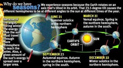
Why do we have seasons?
Why do we have seasons? It is all thanks to the tilt of the Earth's axis. (NASA / NOAA)

We are now in the waning hours of winter as spring is set to arrive in Thornton later today – at 5:21pm to be exact.  The changing of the seasons from winter to spring means longer days, warmer temperatures and a greening landscape.

The Earth experiences seasons thanks to its 23 1/2 degree tilt.  As the planet circles the sun, a process that takes 365 1/4 days, different parts of the Earth are tilted closer to or farther away from the sun.

The vernal equinox (the first day of spring) is the day on which the sun is directly over the Earth’s equator and daylight lasts 12 hours in both the Northern and Southern Hemisphere.  This is because at this point the Earth’s axis is 90 degrees away from the sun.

From now until the summer solstice, those of us in the Northern Hemisphere get closer to the sun and thus enjoy the warming temperatures and experience spring and summer.  In the Southern Hemisphere they experience the opposite and for them today is the first day of autumn.

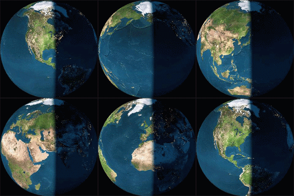
Animated vernal equinox
The vernal equinox brings nearly equal daytime and nighttime across the globe.

Here is Colorado, thanks to our northern latitude, we have already passed the point of 12 hours of equal daytime and nighttime, something that occurred just a few days ago.  Today in fact daytime will last 12 hours and 7 minutes.

Did you know that there is a difference between the astronomical seasons that we are discussing here and meteorological seasons?

Meteorological seasons differ slightly and are geared toward matching the calendar with the annual temperature cycle.  This is done primarily for meteorological observing and forecasting.

For the Northern Hemisphere, the meteorological spring covers the months of March, April and May.  Summer brings the hottest months of the year and so meteorological summer is June, July and August.  Meteorological fall then is September, October and November followed by the coldest months of December, January and February as meteorological winter.

Flood weary Queensland, Australia struck by tropical cyclone

Category 5 Tropical Cyclone Yasi moves inland over flood ravaged Queensland, Australia.  Click the image to view more satellite photos on Examiner.com
Category 5 Tropical Cyclone Yasi moves inland over flood ravaged Queensland, Australia. Click the image to view more satellite photos on Examiner.com (CIMSS)

Devastating flooding over the past month and a half inundated hundreds of thousands of square miles in the Australian state of Queensland.  The last thing the weary residents needed was more stormy weather but that is what came in the form of Severe Tropical Cyclone Yasi. 

Just a few days ago Tropical Cyclone Anthony made landfall on Australia’s northeast coast.  Mercifully it was a relatively small storm.  The same cannot be said of Yasi.

Yasi landed at midnight local time on Thursday as a powerful Category 5 storm packing wind gusts to 186 mph.  Tens of thousands of residents fled the storm as it approached and reports of down trees, roofs ripped off homes and widespread power outages are being seen. 

As reported by the Natural Disasters Examiner:

“This is a cyclone of savagery and intensity,” warned Prime Minister Julia Gillard.  “People are facing some really dreadful hours in front of them.”

Accompanying the damaging wind was destructive storm surge more than six feet high that will likely submerge low lying coastal areas.  Rains from the storm are sure to drench ground already saturated from the massive flooding Queensland has seen in recent weeks and new flooding is likely.

The storm has moved inland and is near the town of Georgetown.  It still is packing powerful punch as a Category 3 cyclone with gusts in excess of 127 mph (205 kph).

Get the complete story on Examiner.com including a look at amazing satellite imagery of the storm as it struck.

Related: NOAA satellite imagery of the flooding in Australia (Examiner.com)

Death toll in Brazilian flooding and landslides climbs over 800

Recent flooding in Brazil has submerged entire towns in water and mud. Image courtesy Blamed (Arquivo pessoal) via Wikimedia Commons

Australia and Brazil have both been besieged by heavy rains and flooding in recent weeks.  While Australia’s damage was more widespread, the death toll in Brazil has been far more severe.

At latest count at least 809 people have been killed in the flooding in areas just north of Rio de Janeiro.  389 are reported dead from the floods and mudslides in Nova Friburgo and 324 in Teresolis.  With at least 200 people missing the toll may eventually exceed 1,000.

More than 20,000 people have been forced out of their homes as flash floods and mud rushed through the Serrana region and the Brazilian government is being heavily criticized for its lax oversight of construction standards. The lack of a proper weather warning system and civil defense plan have also been highlighted by the calamity. 

Many within the country and in the international community are questioning the ability of Brazil to play host to the World Cup and the Olympics later this decade. Brazilian daily newspaper Estado de S. Paulo wrote, “A look at public policy … or the lack thereof … reveals a long chain of unpreparedness, administrative incompetence, technical incapacity, and political irresponsibility.”

The recent deaths far surpass Brazil’s previous worst natural disaster. That event, a flood in the state of Sao Paulo in 1967, claimed 436 lives. 

For complete coverage of all types of natural disasters, please visit the Natural Disasters Examiner.

Aussie teens learn what type of flotation device not to use in a flooding river

Two teens in Australia discovered that certain flotation devices aren't appropriate in a flooding river. (Trevor Pinder)

Sometimes you just can’t save people from themselves.  With Australia battling flooding across four of its states, emergency officials have had their hands full providing relief and rescuing those affected by the disaster.  The Natural Disasters Examiner reports about how the decision by a young couple to test the floodwaters with inflatable sex dolls earlier this week was not met with amusement by authorities. 

The 19-year-old couple chose to enter the waters of the Yarra River near Melbourne with inflatable sex dolls to aid them in their swim.  The rushing waters apparently were too much for the pair – and the dolls – and they soon found themselves in danger.

The young lady held onto a tree while her companion and his doll stood watch and began yelling for help.  A passerby called police and rescue units retrieved the couple from the river.

According to The Telegraph, officials told the couple that sex dolls were “not a recognized flotation device.”  Authorities were not pleased to have had to divert resources for a rescue that should not have been necessary. 

Flooding in Australia has become a disaster of gargantuan proportions as hundreds of thousands of acres across four states have been flooded.  More than 30 people have been killed and tens of thousands of people are now homeless. 

View more images of the water rescue here.

Australian floods continue unabated flooding hundreds of thousands of square miles

This screen capture shows a car being carried away by a flash flood in Toowoomba, Australia. Click the image to watch the amazing video on Examiner.com.

The death toll from the relentless flooding in Queensland, Australia continues to climb as four people were killed in a flash flood.  The rising waters have inundated an area covering hundreds of thousands of square miles and now threaten the city of Brisbane. 

The most recent fatalities, two adults and two children, occurred near the city of Toowoomba when flash floods swept their vehicle from the road.  A wall of water as high as 26 feet (eight meters) raged through the area in the wake of a rainstorm. 

Cars, furniture and people were tossed around by the rushing waters and search and rescue operations continue as fears of additional deaths weigh heavily.  The waters hit with enough intensity to move houses from their foundations and landslides covered highways. 

Premier Anna Bligh told a press conference, “Mother Nature has unleashed something shocking on Toowoomba.”

Continue reading Australian floods continue unabated flooding hundreds of thousands of square miles

Flooding in Australia reaches ‘biblical proportions’, turns deadly

Flooding in Stanthorpe, Queensland, Australia. Rising waters prompted one government officials to call it a disaster of 'biblical proportions.' (Flickr / Michael Jefferies)
Flooding in Stanthorpe, Queensland, Australia. Rising waters prompted one government officials to call it 'a disaster of biblical proportions.' (Flickr / Michael Jefferies) Click the image for more photos of the Australian flooding on Examiner.com.

Residents of Australia’s state of Queensland are facing an extraordinary deluge following record-setting rain.  In recent weeks an unusually heavy rainy season coupled with Tropical Storm Tasha has affected an area of land bigger than France and Germany combined.

Queensland’s state treasurer Andrew Fraser  told media last week, “It is a disaster of biblical proportions.” 

NASA satellite measurements of the rainfall indicated from 10 to 16 inches of rain fell within a week.  Many rivers have overrun their banks including the Fitzroy River which is sending water into the city of Rockhampton. 

Disaster declarations have been made for an area encompassing 366,000 square miles and 41 of Queensland’s 73 municipalities.  An estimated 200,000 residents are affected by the floods and tens of thousands have been evacuated. 

Government officials said 22 towns were either entirely flooded or isolated by flood waters.  At least 10 deaths have been attributed to the flooding and rivers have yet to crest. 

For more, please visit the Natural Disasters Examiner:

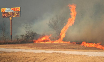
Brazilian wildfire spawns fire tornado

Fire tornadoes, sometimes called fire whirls or fire devils, are formed when heated air from a fire rises and rotates. This vertical column of air can pull fire into it turning it into an amazing display of nature’s fury.
Fire tornadoes, sometimes called fire whirls or fire devils, are formed when heated air from a fire rises and rotates. This vertical column of air can pull fire into it turning it into an amazing display of nature’s fury. Watch video of one in Brazil below.

Dry conditions, abundant fuel and strong winds create dangerous wildfire conditions. When in the right combination, a rare event – a fire tornado – can occur and one was captured on video in Brazil yesterday.

Coloradoans are not strangers to the dangers of wildfires. A relatively wet winter and summer has allowed us to escape relatively unscathed so far this year. Other parts of the globe however have not been so lucky.

In Russia, fires have burned hundreds of thousands of acres and sent plumes of smoke thousands of miles from western Russia to Siberia. The smoke has been so extensive it can be seen by NASA satellites 22,300 miles above the Earth.

Brazil as well has seen extensive wildfire activity in the last few weeks due to a drought. The brush fires have been fueled by the dry brush and they have devastated open land and destroyed homes.

Videographers filming near the city of Aracatuba in the Brazilian state of Sao Paolo captured a fire tornado yesterday as it tore through a Brazilian field. The rare event results when hot air on the surface rises and is twisted by winds thus pulling the fire vertically.

Fires across Russia spotted by NASA satellites

Satellite imagery released by NASA clearly shows the extent of the smoke plume from wildfires burning in western Russia. (NASA) Click the image to view a slideshow of the wildfires as seen from space.

More than 600 wildfires burning across Russia have clouded the skies and claimed the lives of at least 50 people. NASA has trained its satellites on the nation capturing imagery of the blazes as they continue to burn.

Seven regions of Russia are under state of emergency as officials struggle to gain an upper hand against the fires. All told, estimates are that more than 484,000 acres (196,000 hectares) have been scorched with no end in sight.

President Dmitry Medvedev fired several military officials today for their inability to slow the fires. Thousands of people have lost their homes as the flames continue unabated. A naval base in Kolomna was destroyed last week and a nuclear research facility in Sarov is now threatened.

The choking smoke over places like Moscow has added to the misery of what has been an unusually hot summer. The plumes of smoke are so extensive they can easily be captured by NASA satellites orbiting 22,300 miles above the surface of the Earth.

The imagery below was captured by NASA’s Terra satellite yesterday. In the top image, the plumes of smoke from the fires in western Russia stretch more than 1,800 miles (3,000 km). The lower image shows a closer view of the fires burning southeast of Moscow.

Satellite image showing the extent of the smoke plume from fires burning in Russia (NASA)
NASA satellite image of wildfires burning near Moscow, Russia. (NASA)

Satellite image of smoke from wildfires burning southeast of Moscow (NASA)
Satellite imagery of smoke from fires in western Russia. (NASA)

From NASA:

Intense fires continued to rage in western Russia on August 4, 2010. Burning in dry peat bogs and forests, the fires produced a dense plume of smoke that reached across hundreds of kilometers. The Moderate Resolution Imaging Spectroradiometer (MODIS) captured this view of the fires and smoke in three consecutive overpasses on NASA’s Terra satellite. The smooth gray-brown smoke hangs over the Russian landscape, completely obscuring the ground in places. The top image provides a close view of the fires immediately southeast of Moscow, while the lower image shows the full extent of the smoke plume.

The fires along the southern edge of the smoke plume near the city of Razan, top image, are among the most intense. Outlined in red, a line of intense fires is generating a wall of smoke. The easternmost fire in the image is extreme enough that it produced a pyrocumulus cloud, a dense towering cloud formed when intense heat from a fire pushes air high into the atmosphere.

The lower image shows the full extent of the smoke plume, spanning about 3,000 kilometers (1,860 miles) from east to west. If the smoke were in the United States, it would extend approximately from San Francisco to Chicago. The MODIS sensor acquired the right section of the image starting at 5:55 UTC (10:55 a.m. local time, 8:55 a.m. in Moscow). The center section is from the overpass starting at 7:35 UTC (11:35 local time, 10:35 in Moscow), and the westernmost section was taken at 9:10 UTC (12:10 p.m. local time in Moscow).

Early analyses of data from the Multi-angle Imaging Spectroradiometer (MISR), another instrument on the Terra satellite, indicates that smoke from previous days has at times reached 12 kilometers (six miles) above Earth’s surface into the stratosphere. At such heights, smoke is able to travel long distances to affect air quality far away. This may be one reason that the smoke covers such a large area. The pyrocumulus cloud and the detection of smoke in the stratosphere are good indicators that the fires are large and extremely intense.

According to news reports, 520 fires were burning in western Russia on August 4. MODIS detected far fewer. It is likely that the remaining fires were hidden from the satellite’s view by the thick smoke and scattered clouds. High temperatures and severe drought dried vegetation throughout central Russia, creating hazardous fire conditions in July.

As of August 4, 48 people had died in the fires and more than 2,000 had lost their homes throughout central Russia, said news reports. The dense smoke also created hazardous air quality over a broad region. Visibility in Moscow dropped to 20 meters (0.01 miles) on August 4, and health officials warned that everyone, including healthy people, needed to take preventative measures such as staying indoors or wearing a mask outdoors, reported the Wall Street Journal. In the image, Moscow is hidden under a pall of smoke. Close to the fires, smoke poses a health risk because it contains small particles (soot) and hazardous gases that can irritate the eyes and respiratory system. Smoke also contains chemicals that lead to ozone production farther away from the fires.

The large image provides the full scene shown in the lower image at the sensor’s highest resolution (as shown in the top image). The MODIS Rapid Response Team provides the scene in additional resolutions.

References

  1. BBC News. (2010, August 4). Medvedev cuts holiday as Russian wildfires kill 48. Accessed August 4, 2010.
  2. Iosebashvili, I. (2010, August 4). Death toll rises as Russian fires rage. Wall Street Journal. Accessed August 4, 2010.

NASA image courtesy Jeff Schmaltz, MODIS Rapid Response Team at NASA GSFC. Caption by Holli Riebeek with information courtesy Mike Fromm, Naval Research Laboratory.