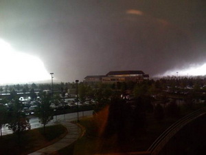
May 22, 2008 was like most any spring day along the Colorado Front Range. The morning started out a bit warmer than usual and it was more humid but there was nothing to indicate the havoc that was soon to be visited upon Windsor, Colorado.
As the morning wore on, high above the plains the jet stream was moving at 120 mph and temperatures were warming quickly. From Denver looking north huge clouds began to build miles into the sky – an ominous sign of what was to come. A supercell thunderstorm, one more like what you expect to see in Oklahoma, was forming quickly.
At 11:30am the warnings were going out from the National Weather Service. This was not your typical thunderstorm. Soon a Gilcrest police officer radioed, “We have a tornado on the ground!”
Three tornadoes touched down that morning in northern Colorado but one stands out. The supercell that was near Windsor was growing in size and the twister that developed was massive – ¾ of a mile wide. Rated by the National Weather Service as an EF3 on the Enhanced Fujita Scale with winds in excess of 136 mph, what was described as a “big, black monster” would tear a path 35 miles long.
For the rest of this story including video and a photo slideshow, please visit Examiner.com.
