Colorado researchers join VORTEX2 tornado project

This tornado in Goshen County, Wyoming in 2009 was intercepted by VORTEX2 teams and is considered the “most intensely examined tornado in history.” (NOAA)  Watch video of the twister and see more photos at the complete story on Examiner.com. (NOAA)
This tornado in Goshen County, Wyoming in 2009 was intercepted by VORTEX2 teams and is considered the “most intensely examined tornado in history.” (NOAA) Watch video of the twister and see more photos at the complete story on Examiner.com. (NOAA)

For the second year in a row, a team of over 100 scientists and dozens of vehicles will take to Tornado Alley in an attempt to study one of Mother Nature’s most destructive phenomena. Like last year, Colorado researchers will be helping with the project.

Among the Colorado-based participants are University of Colorado students and researchers. They join others from 11 other universities from across the nation including the University of Oklahoma, Penn State University, and the University of Massachusetts.

Perhaps most well known, Dr. Josh Wurman of the Center for Severe Weather Research (CSWR) in Boulder will be a key contributor. Watchers of the Discovery Channel’s Storm Chasers series know Wurman well as the operator of a Doppler On Wheels (DOW) radar truck and coordinator of the TV series’ storm chases.

Verification of the Origins of Rotation in Tornadoes Experiment 2 (VORTEX2) is simply the largest, most extensive in-field tornado study in history. Funded by the National Science Foundation (NSF) and the National Oceanic and Atmospheric Administration (NOAA), the VORTEX2 team will prowl the Great Plains hunting their elusive prey from May 1st to June 15th.

Once again, a veritable armada of scientific equipment will be deployed. Ten mobile radar units, dozens of vehicles, over 70 other instruments and even an Unmanned Aerial Vehicle (UAV) will cover thousands of miles on the Great Plains.

There's more to this story on Examiner.com!For the rest of this story including photos of all the equipment and amazing video of the tornado in Wyoming that the team intercepted last year, visit the Denver Weather Examiner.

May’s weather preview – Four seasons in one month

Thornton's May weather previewColorado natives and those that have lived here long enough know that Denver and Colorado weather changes considerably throughout the year. The month of May almost seems to pack four seasons of weather conditions into 31 days. You name it, it can happen.

This being the latter half of spring, May does mean warm temperatures. Temperatures in the 80’s are common and reaching into the 90’s is not unheard of. The normal highs start out at 65 on the first but by the end of the month that climbs to 76. The record high for the month was recorded on May 26, 1942 of 95 degrees.

The temperatures aren’t always mild in May and the weather conditions can certainly get wild.  Get all the details in our complete May weather preview.

Severe weather outbreak turns deadly, 10 killed in Mississippi

Storm Prediction Center reports for Saturday, April 24, 2010
Storm Prediction Center reports for Saturday, April 24, 2010. Click on the image for a slideshow of the damage.

Severe weather across the South on Saturday turned deadly as tornadoes ripped through the region. Mississippi was hardest hit as one twister in Yazoo County killed 10 people and officials fear more could lie buried under the rubble.

Yazoo County was ground zero for the worst of the devastation where officials estimate 100 homes were destroyed. Mississippi Governor Haley Barbour described the scene as “utter obliteration.”

Images of the scene were heart wrenching and show homes reduced to nothing but scattered lumber. A church was destroyed, cars tossed about like toys and trees snapped like twigs and left without foliage.

Widespread power outages were reported as power lines were downed by the intense fury of the storms.  Officials said thousands remained without power as of Sunday morning.

The human toll was staggering and covered three Mississippi counties. Five people were killed in Choctaw County, four in Yazoo County and one in Holmes County. The Mississippi Emergency Management Agency reported that two children were among the dead including a three month old baby.

Get the rest of this story including photos of the destruction from the Natural Disasters Examiner.

April 25 to May 1 – This week in Denver weather history

April 25 to May 1 – This week in Denver weather history

Snow continues to be a big part of the weather we can expect this time of year as we peer back in the Denver weather history books.  However, we also see more and more occurrences of spring severe weather including hail, damaging winds, dangerous lightning and even a tornado.

23-25

In 1935…heavy wet snow fell across metro Denver.  The storm started as rain on the 23rd and changed to snow early on the morning of the 24th.  There was continuous precipitation for a period of 48 hours.  Snowfall totaled 19.0 inches over the city and 20.0 inches at Denver municipal airport.  However… Due to warm temperatures in the 30’s…much of the snow melted as it fell and did not seriously disrupt traffic. The greatest snow accumulation on the ground downtown was 12 inches…but it quickly melted.  The highest sustained wind speed recorded during the storm was 28 mph from the north on the 23rd.  The storm contained 3.16 inches of moisture.

24-25

In 1890…rain changed to snow and totaled 7.0 inches in downtown Denver.
 
In 1931…heavy snowfall totaled 9.3 inches over downtown Denver.  Winds were light during the storm.
 
In 1996…the second wind storm in less than a week developed east of the continental divide and spread over metro Denver.  High winds gusted from 60 to 90 mph.  Several power lines and poles were downed.  Some of the stronger wind gusts included:  91 mph atop Squaw Mountain west of Denver…90 mph atop Table Mesa near Boulder…85 mph in Golden Gate Canyon…and 82 mph at Wondervu.  Northwest winds gusted to 41 mph at Denver International Airport on the 25th.

24-26

In 1924…post-frontal rain changed to snow…which became heavy and totaled 10.2 inches over downtown Denver.  The greatest amount of snow on the ground was 6.0 inches on the 25th due to melting.  North winds were sustained to 38 mph with gusts to 42 mph on the 24th.

25

In 1902…northeast winds were sustained to 42 mph with gusts to 48 mph.
 
In 1908…north winds were sustained to 40 mph behind an apparent cold front.  Snowfall was 0.5 inch.
 
In 1928…rain changed to snow…which became heavy and totaled 7.4 inches in downtown Denver.  Due to melting…the maximum snow depth on the ground was 4.0 inches at 6:00 pm.  This was the last snow of the season.  Southeast winds were sustained to 19 mph with gusts to 20 mph.
 
In 1976…a south wind gust to 54 mph was recorded at Stapleton International Airport.  The high winds toppled a 70-foot high cottonwood tree onto the rear of house and a neighboring residence in central Denver.
 
In 1989…lightning caused heavy damage to a radio transmitter in Parker…knocking a Denver area radio station off the air for 3 hours.
 
In 1994…weather spotters reported dime-size hail at the intersection of U.S. Highway 287 and C470 in Jefferson County.  Marble-size hail covered the ground near Golden to a depth of 1 inch.  Pea-size hail was reported covering the ground to a depth of 3 inches in Arvada.

Continue reading April 25 to May 1 – This week in Denver weather history

NASA releases photo album of the Earth on anniversary of Earth Day

In honor of the 40th anniversary of Earth Day, NASA has released a collection of images of our globe as seen from space. Check out the complete set in the slideshow below.

Today marks the 40th anniversary of the first Earth Day, an event designed to bring awareness to environmental and climate concerns. In celebration of the event, NASA’s Goddard Institute of Space Studies has released a ‘best of’ collection of images of the Earth.

Manned and robotic spaceflight has allowed us to see the planet as was never possible. Images of our “blue marble” have become commonplace and it is hard to believe it was only 50 years ago that the first images of Earth taken in space were shown on television.

Satellites, space stations, Space Shuttles, robotic probes and more have beamed back images of the globe from orbit, the moon and even Mars.

In their most common form, these images are used to help analyze and predict the weather and are even routinely included in our daily weather forecasts.  From monitoring the effects of climate change and the recent eruption of Iceland’s Eyjafjallajokull volcano amaze us today much as they did in 1960.

Below is a collection of images released today by NASA in honor of Earth Day 2010.

In pictures - NASA releases collection of Earth Day photos

Breaking weather situation – Tornado watches and warnings posted

Live Thornton, Colorado weather image.

 Update, 5:15pm – The Tornado Watch for Adams County has been discontinued.  

We did see a number of tornadoes reported in Colorado so far today, mostly in the southeastern part of the start.  

In northeastern Colorado, two tornadoes were reported. One was reported at 3:28pm 9 miles southwest of Deer Trail in Elbert County. The second at 3:38pm two miles north of Leader in Adams County.

A very, very wet weather pattern will continue through Saturday and the chance for severe weather remains.  Be sure to stay tuned to ThorntonWeather.com! 

Update, 4:30pm: The Tornado Watch for Denver, Boulder, Broomfield and Jefferson Counties has been dropped. However, they remain in effect until 8:00pm for Adams, Arapahoe, Morgan, Washington, Weld, Elbert and Lincoln Counties. 

Two tornadoes have been reported so far. The first was at 3:28pm nine miles southwest of Deer Trail. The second was 10 minutes later at 3:38pm two miles west of Leader. No damage reports at this time. 

Original story, 3:30pm: Yesterday brought our first Severe Thunderstorm Warning of the season and today the situation gets more serious with Tornado Watches and Warnings being posted.  The severe weather threat looks to continue through the afternoon.  

A Tornado Watch has been issued for much of the Front Range including all of Adams, Arapahoe, Boulder, Broomfield, Denver, Douglas, Jefferson, Morgan, and Weld Counties.  This watch includes the entire Denver metro area including Thornton.   

Remember that a Tornado Watch means conditions are favorable for the development of severe thunderstorms producing tornadoes in and close to the watch area.   

Showers and thunderstorms are expected to continue to develop across the Front Range this afternoon and evening.  These are expected to include heavy rain, strong winds, hail and possibly hail.  Residents need to take immediate precautions to protect themselves.  

Remember, Thornton and Adams County do NOT have any type of weather warning system for residents – no sirens, text alerts, etc.  You should have your own NOAA weather radio or stay tuned to local media (and ThorntonWeather.com of course) for all the latest when severe weather strikes.  

Celebrating Earth Day 2010 – Climate predictions then and now

Are we approaching the end of times? On the first Earth Day in 1970 scientists, poiliticans and pundits gave mankind little hope for survival. That tactic continues today. (Discovery Channel)

Today we celebrate that most auspicious occasion – Earth Day.  It is a day in which we can all ‘be green’, hold hands, sing Kumbaya and be one with Mother Earth. 

With the ongoing debate about manmade climate change, it affords us an opportunity to evaluate what “experts” were saying 40 years ago and what they are saying now.  

Many parallels between the two times can easily be drawn.  Over the top rhetoric and predictions were apparently as common in 1970 as they are today. 

The Climate Change Examiner has a great look back at some of the predictions made on the first Earth Day as well as some that are being made in current times.  Here is a brief excerpt – be sure to follow the link below to view the whole story.

Forty years ago Earth Day was founded as a way to give greater visibility to environmental concerns across the globe. The event is celebrated annually and while the focus has now shifted to one primarily on manmade climate change, just like in 1970, today we continue to hear dire warnings of man’s impending doom.

From that very first Earth Day, laying out a reasoned case to spur the public into action was not deemed adequate. Instead, the use of predictions of the end of times were used as a scare tactic.

The founder of Earth Day, Senator Gaylord Nelson was not shy about using hyperbole to drive home his belief of the dangers presented. He famously proclaimed that, “Dr. S. Dillon Ripley, secretary of the Smithsonian Institute, believes that in 25 years, somewhere between 75 and 80 percent of all the species of living animals will be extinct.”

It would appear that something miraculous occurred since that first Earth Day and today as the Earth is teeming with life just as it was then.

Questionable claims of impending doom continue

In the intervening time we can clearly see that these were nothing more than weak attempts to steer public opinion toward what was the ‘consensus’ at the time by scaring people into action. The names of the scientists and public policy ‘experts’ making the claims have changed in the past forty years but the tactic remains.

Will the seers of today like Gore, Hansen and Lovelock be any more accurate in their predictions than Ehrlich, Nelson or Gunter was in their day?

Check back in 40 years – If humankind is still here.

There's more to this story on Examiner.com!Be sure to read the complete story: Earth Day 2010 – Celebrating 40 years of outrageous predictions of doom

Volcanic lightning on display in Iceland

The Chaitén volcano erupting in Chile in 2008. (Carlos Gutierrez)

The images are nothing less than astounding – so unreal appearing in fact that the reaction of many people is to conclude they are fake. However, volcano-induced lightning is a very real phenomenon and one that is not well understood.

The Eyjafjallajokull volcano in Iceland erupted last month and that event was followed by a larger eruption on Wednesday, April 14th. While not a big eruption by most standards, volcano-induced lightning was once again photographed.

Images of the light show put on by Eyjafjallajokull were taken by many photographers including the Associated Press as well as astronomer and volcano expert Marco Fulle. Fulle’s images – click here to view them – show lightning shooting from the ash plume as the stars pass overhead in an amazing display of nature’s fury.

In May of 2008 the Chaitén volcano in Chile erupted for the first time in more than 9,000 years. In an impressive explosive eruption, nighttime images taken by Carlos Gutierrez displayed lightning shooting from the rising plume of ash, smoke and steam. So incredible were the images that many believed they were digitally manipulated even prompting myth-busting website Snopes to issue a story explaining that they were real.

Because of copyright protections we cannot display all of the images of volcano-induced lightning here but we encourage you to head over to the Natural Disasters Examiner to check them out.  They are truly amazing.

April 18 to April 24 – This week in Denver weather history

April 18 to April 24 – This week in Denver weather history

April can truly bring just about any kind of weather to the Denver area.  From blizzards and snowstorms that are more common in the deepest part of winter to severe spring-like weather like tornadoes and hail, we can and do see it all.  Our look back at this week in Denver weather history shows all of those conditions and more.

17-18

In 1878…the wind blew violently all day on the 17th with a maximum sustained velocity of 40 mph.  Dust hung over the city like a cloud.  The relative humidity was zero nearly all day.  A terrific gale blew overnight.  There was much damage to buildings…signs…fences…etc.  Some wind gusts were so strong as to jar buildings to their foundations.  The station anemometer recorded sustained winds to 50 mph with higher gusts before it was damaged by the winds.  The winds moderated during the day on the 18th and ended at sunset.
 
In 1894…post-frontal rain changed to snow on the 17th around sunrise and continued through 9:00 am on the 18th. Snowfall totaled 10.5 inches…but most of the snow melted as it fell.  The high temperature warmed to only 35 degrees on the 17th after a high of 76 on the 16th.  Northeast winds were sustained to 30 mph with gusts to 32 mph on the 17th.
 
In 1998…more spring snow fell across metro Denver and in the foothills.  Snowfall totals included:  11 inches at Golden Gate Canyon; 10 inches at Highlands Ranch; 9 inches at Elizabeth; 8 inches at Broomfield and Morrison; and 7 inches at Chief Hosa…Evergreen…Littleton…and Sedalia. Snowfall totaled only 3.2 inches at the site of the former Stapleton International Airport.  North winds gusted to 22 mph at Denver International Airport.

17-19

In 1920…snow fell across the city continuously for 57 hours… From the early morning of the 17th until 11:40 am on the 19th.  The heavy wet snowfall totaled 18.2 inches with the greatest accumulation on the ground of 12 inches.  Winds during the storm were strong with sustained speeds in excess of 27 mph for over 40 consecutive hours…which created near-blizzard conditions.  The highest recorded wind speeds were 44 mph with gusts to 50 mph from the north on the 17th and 39 mph with gusts to 48 mph from the northwest on the 18th.  The strong winds piled the snow into high drifts which stopped all Denver traffic. Railroads were blocked with only one train entering the city on the 19th.  All interurban trains were blocked…as were the 13 trolley lines.  Thus…many workers were unable to get home at night and filled all of the downtown hotels to capacity.  No grocery or fuel deliveries were possible… Except milk and coal to hospitals and to families with babies.  No lives were lost in the city…but several people perished in surrounding districts.  Stock losses were heavy on the plains.  Temperatures during the storm were in the 20’s.

18

In 1877…strong winds blew all day with an average sustained velocity of 36 mph.  The maximum sustained velocity was 60 mph.  No significant damage was reported.
 
In 1903…northwest winds were sustained to 48 mph with gusts to 53 mph.
 
In 1936…light dust spread over the city from the east on southeast winds gusting to 25 mph.  The surface visibility was reduced to about 2 miles at times.
 
In 1940…this date marked the start of the longest period without snow…200 days…through November 3…1940.  A trace of snow fell on both April 17…1940…and November 4…1940.
 
In 1963…strong winds were prevalent all day across metro Denver.  West-northwest winds gusting to 60 mph produced some blowing dust at Stapleton Airport.
 
In 1971…a microburst wind gust to 59 mph produced some blowing dust at Stapleton International Airport.
 
In 1978…high winds caused much blowing dust over the plains. Wind gusts from 80 to 96 mph were reported in Boulder with 80 mph measured on Lookout Mountain.  Northwest winds gusted to 43 mph at Stapleton International Airport.
 
In 2000…high winds developed in the foothills of Boulder County.  Peak wind gusts included 71 mph at the National Center for Atmospheric Research Mesa Lab near Boulder. In Aurora…three workers were injured when strong winds caused a home under construction to partially collapse. Two received minor injuries…while the third worker had to be hospitalized with severe back injuries.  South winds gusted to 47 mph at Denver International Airport.
 
In 2002…strong northeast winds behind a cold front gusted to 53 mph at Denver International Airport where some blowing dust briefly reduced the visibility to 3 miles.

Continue reading April 18 to April 24 – This week in Denver weather history

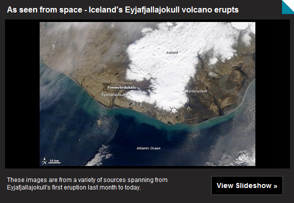
Satellite imagery of Iceland volcano eruption

Satellite image of the Eyjafjallajokull volcano in Iceland erupting
NASA's Terra satellite flew over the volcano on April 16 10:45 UTC (6:45 a.m. EDT) and the MODIS instrument captured a visible image of Eyjafjallajökull's ash plume (brown cloud) stretching from the U.K. (left) to Germany (right). (NASA/MODIS Rapid Response Team) Click on the image or on the link below to view a slideshow of satellite photos of the eruption.

Satellites by space agencies across the globe have trained their ‘eyes in the sky’ on Iceland and the erupting Eyjafjallajokull volcano. From their perch hundreds of miles above the Earth’s surface, these satellites can capture images of the volcano and its ash plume as it travels across northern and central Europe.

The ash cloud has now traveled hundreds of miles over northern Europe where it has created the biggest travel disruptions since the September 11th terrorist attacks. Thousands of flights have been cancelled and hundreds of thousands of passengers have been stranded across the world.

At Denver International Airport, United Airlines and British Airways cancelled their non-stop service to and from London’s Heathrow airport Saturday. This marks the third day in a row for the disruption.

The volcanoes activity increased overnight and continues on Saturday. Eurocontrol, the European agency responsible for air travel over the continent, reports that 16,000 flights had been cancelled on Saturday. On a normal Saturday the organization would monitor 22,000 flights.

Satellite images in the slideshow below from NASA, the European Space Agency (ESA) and others provide an incredible look into the event.    

Image of Iceland's Eyjafjallajokull volcano

Weather, natural disasters & climate news and information.