Amazing winter allows 49 states to record snow on the ground

More than two thirds of the United States recorded snow no the ground on Friday.  (National Weather Service)
More than two thirds of the United States recorded snow no the ground on Friday. (National Weather Service)

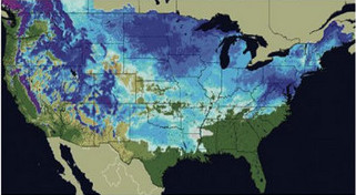
It seems so improbable that no one was sure whether or not it has happened before but there was snow on the ground in 49 of the 50 states on Friday. The unlikely event was possible thanks to snow that hit unusual places like Texas and Florida.

According to the National Weather Service, 67.1 percent of the United States’ total land area was covered by snow yesterday. That far exceeds the 40 to 50 percent normally seen this time of year.

Dallas, Texas recorded an improbable 12.5 inches of snow breaking records for the date and pushing the city to its second snowiest winter on record and its snowiest in 32 years. Not to be left out, snow was on the ground in Arkansas, Alabama, Georgia and even the Florida Panhandle.

Residents in some places in the United States are wishing things weren’t nearly as snowy. The Mid-Atlantic region has experienced record setting snowfalls this year.

Baltimore, Washington D.C., Philadelphia, Wilmington and Atlantic City have all set new records for seasonal snowfall. Many of those cities have experienced more snow than their counterparts in the Rocky Mountain region.

So what was the one state that held out without snow? Hawaii. This is actually unusual as the Mauna Kea volcano peaks at 13,800 feet and often times has snow on it. Research meteorologist Tiziana Cherubini at the Mauna Kea Weather Center told the Associated Press the mountain had been without snow for a few weeks and none is in the forecast.

Officials at Rutgers University’s Global Snow Lab and with the National Weather Service are trying to determine if all 50 states have recorded snow on the ground at the same time. They have verified that 49 states have previously on January 19, 1977 when South Carolina was the lone holdout.

National Weather Service meteorologists attribute the snowy conditions to a moderate El Nino event in the Pacific Ocean and the Arctic Oscillation. In El Nino seasons, moisture streams across the south. The Arctic Oscillation brings colder air from the north dropping temperature and allowing any precipitation that might fall to turn to snow.

There's more to this story on Examiner.com!For a complete look at the crazy winter weather across the nation, be sure to visit the Natural Disasters Examiner.

It’s finally over – Mid-Atlantic digs out from record-setting snowstorms

The history making snowstorm that pushed many East Coast cities’ snow totals into the record books has moved out. Now residents begin the monumental task of digging out from snow depths the likes of which have never been seen.

Philadelphia, Washington D.C., and Baltimore were just some of the major cities on the east coast to be struck by what some have called ‘Snowmageddon.’ Last week a major winter storm dumped over two feet of snow on major cities in the Mid-Atlantic. Residents had just finished digging out from that event when Mother Nature delivered another wallop Tuesday and Wednesday.

Separately, the two storms in the past week and a previous one in December ranked each in many cities’ ‘top 10’ snow events. Collectively, the storms have dumped more snow than the region has ever seen in a single season.

How much snow fell?  Check out the astounding snowfall totals at the Natural Disasters Examiner.

NOAA announces new climate change portal

NOAAs new Climate.Gov website is supposed to provide a single point-of-entry for NOAA’s climate information, data, products and services.  (NOAA)
NOAA's new Climate.Gov website is supposed to provide a 'single point-of-entry for NOAA’s climate information, data, products and services.' (NOAA)

The National Oceanic and Atmospheric Administration (NOAA) has announced its new ‘portal to climate information’ at the web address Climate.Gov. The site is to serve as a consolidated home to climate information from across all of NOAA’s various departments.  The site has potential but despite the announcement, some of the information on the site is already out of date.

The new site was announced yesterday by Commerce Secretary Gary Locke and NOAA Administrator Jane Lubchenco. Ironically, the Gore Effect seemed to be in full force as the major winter snowstorm that struck Washington D.C. forced the press conference to be held by telephone.

The NOAA Climate Service Portal will go hand in hand with the proposed NOAA Climate Service, a new branch of NOAA that officials want to become the one-stop-shop for climate information from the U.S. government. “We envision this climate portal as the first step toward making the wealth of climate information at NOAA available in one easy-to-use resource,” Lubchenco said.

  • An interactive “climate dashboard” that lets users see a range of constantly updating climate datasets (e.g., temperature, carbon dioxide concentration, and sea level) over adjustable time scales;
  • A new Web-based climate science magazine called ClimateWatch, featuring videos and articles of scientists discussing their recent climate research and topics that cannot be relayed in charts and graphs;
  • Explanations and exploration of data products available from NOAA and partner agencies, with direct links to the sources of the comprehensive datasets;
  • Educational resources for students and teachers, including lesson plans for the classroom and laboratory, educational games and interactive media; and
  • Easy-to-understand fact sheets and presentations for professionals and the public about climate science, research and climate impacts.

There's more to this story on Examiner.com!The site is a great looking one but there are some problems.  Read about that in the complete story on the Climate Change Examiner.

From Philly to Washington to New York, East Coast slammed by blizzard

The adjectives to describe last week’s record-setting snowstorm no longer seem adequate to describe the winter weather striking from the Mid-Atlantic to New York. A second potentially more severe storm that the National Weather Service described as ‘life threatening’ is battering Washington D.C., Baltimore, New York City and every place in between.

Storms that dumped more than two feet of snow last week were bad enough but the latest storm has introduced another element – wind. Gusts of 35 mph to 45 mph are expected and coupled with snowfall amounts of more than a foot, snow drifts to four feet are forecast for some areas.

Widespread power outages are likely to become common as the wind and heavy snow takes its toll on an already taxed infrastructure. Road crews who were still working to clear the snow from the last storm are now struggling to stay ahead of the mounting snow totals.

Blizzard Warnings have been posted for Philadelphia, Washington D.C., Baltimore, and New York City. Forecast snow accumulations range from 6 to 12 inches in Washington to 12 to 22 inches in Philadelphia and 10 to 16 inches in New York City. Underscoring the dangerous conditions from the wind and snow, the National Weather Service warning said, “This is a life threatening situation for anyone who becomes stranded.”

Officials were urging all area residents to hunker down and wait the storm out. Public schools, businesses and even the federal government have ceased operations for the day.

There's more to this story on Examiner.com!For more details including the travel mess the storms have created and the astounding snow totals, see the complete story on the Natural Disasters Examiner.

Gore Effect strikes again – Forces NOAA to change announcement of new climate agency

Snowmageddon forced government officials to announce their proposed new climate agency via teleconference instead of at a press conference.  Was it the Gore Effect at work?
'Snowmageddon' forced government officials to announce their proposed new climate agency via teleconference instead of at a press conference. Was it the Gore Effect at work?

With a great deal of hype yesterday, the United States Department of Commerce announced its vision for a new government climate agency spearhead by the National Oceanic and Atmospheric Administration (NOAA). Planned as a media event at the National Press Club yesterday, officials were forced to instead make the announcement via teleconferencing due to the major winter storm that struck the nation’s capital and shut down the federal government.

It was ironic that the announcement of the NOAA Climate Service had to be changed due to the extreme winter weather. In recent years the term ‘Gore Effect’ was coined to explain the unseasonable weather that oftentimes accompanies appearances by former vice president and Nobel Laureate Al Gore or when a global warming event is held.

Cold and snow have followed Al Gore and these events across the globe with amazing frequency since 2004. Hearings and press conferences about climate change in the nation’s capital have been besieged by winter storms and global warming events across the earth have been struck by severe cold in recent years. Just this past December, the United Nations Climate Change Conference felt the Gore Effect when severe cold and snow arrived in Copenhagen as international delegates worked on a global warming agreement.

Climate officials are quick to point out that what used to be termed ‘global warming’ is now called ‘climate change’ and has little to do with short term weather. The shift in vernacular has been made in recent years to allow climate scientists to better explain virtually any weather or climate condition that falls outside the norm.

Climate Change ExaminerFor all the latest climate change news, please visit the Climate Change Examiner.

‘Snowmageddon’ spotted by NASA satellite

e extent of snowfall from the major winter storm that struck the Mid-Atlantic states last week is easily seen from NASA satellites. (NASA) See a larger version below.
The extent of snowfall from the major winter storm that struck the Mid-Atlantic states last week is easily seen from NASA satellites. (NASA) See a larger version below.

This past Friday and Saturday the Mid-Atlantic states were smashed by a record-setting snowstorm that left more than two feet of snow in many areas. The snow brought the nation’s capital to a grinding halt and now the extent of the storm’s wrath can be seen from space.

NASA’s Terra satellite flew over the area on Monday and was able to capture amazing imagery showing the widespread snow cover. The image to the right and the larger version below clearly show Washington D.C., Baltimore, and Philadelphia buried under a significant blanket of white.

Even as area residents continue to dig out from the snow and power companies try to restore power to tens of thousands, a second blast of winter is set to arrive today. That storm may generate nearly as much snow and will certainly push most major cities in the area to record seasonal snowfall totals.

Heavy Snow around U.S. Capital – February 8, 2010 (NASA)
Heavy Snow around U.S. Capital - February 8, 2010 (NASA)

2010 storm spotter training dates announced

Last year's "Summer of Storms" should serve as a reminder of the severe weather threat in Denver.

Remember last year’s “Summer of Storms” that saw a seemingly endless parade of hail, funnel clouds and tornadoes visit the Front Range?  The severe weather threat in Colorado is real and it can turn deadly in an instant. 

Education is key to knowing how to protect you and your family.  Whether you want to be an official storm spotter or maybe just want to learn more about severe weather, storm spotter training can provide you an incredible opportunity to learn. 

The National Weather Service Denver / Boulder office has announced a series of storm spotter training dates for Colorado for the 2010 season. 

The storm spotter program is a nationwide program with more than 280,000 trained spotters.  These volunteers report weather hazards to their local National Weather Service office providing vital information when severe strikes.  Data from spotters include severe wind, rain, snow measurements, thunderstorms and hail and of course tornadoes. 

Storm spotters are part of the ranks of citizens who form the Nation’s first line of defense against severe weather. There can be no finer reward than to know that their efforts have given communities the precious gift of time–seconds and minutes that can help save lives.

By completing one of these training classes you can become an official storm spotter.  When severe weather strikes, you can report it by calling a special toll free number or submit your report via the National Weather Service’s website.

These are great sessions for anyone wanting to learn more about the severe weather we experience in Colorado, whether you want to be an official spotter or not.  All training is free.  Topics include:

  • Basics of thunderstorm development
  • Fundamentals of storm structure
  • Identifying potential severe weather features
  • Information to report
  • How to report information
  • Basic severe weather safety

To learn more about the program, see here: http://www.crh.noaa.gov/bou/awebphp/spotter.php

Below are the dates, times and locations announced thus far.  There is one this coming weekend in north Denver, two in Westminster in March and one in Commerce City in April – all are great opportunities for Thornton residents.  Click here to go to the NWS site for the latest.

 
February, 2010 – Upcoming
Day City, State Time Location
14 Denver, CO(Denver County) 1:00pm MST note: Following National Storm Chaser conference.
There is a charge for the conference, spotter training is free.
Red Lion Hotel Central
4040 Quebec Street
Denver, CO 80216
  Contact Information: Robert.Glancy@noaa.gov
 
March, 2010 – Upcoming
Day City, State Time Location
08 Holyoke, CO(Philllips County) 10:00am MDT Phillips County Fairgrounds
Event Center
Holyoke, CO
  Contact Information: philcoadmin@pctelcom.coop
08 Julesburg, CO(Sedgwick County) 6:00pm MST Julesburg Fire Department
  Contact Information: sedgwickcooem@yahoo.com
09 Haxtun, CO(Phillips County) 6:30pm MST Haxtun Volunteer Fire Dept.
  Contact Information: jdavis@pctelcom.coop
16 Westminster, CO(Adams County) 2:30pm MDT Front Range Community College
3645 West 112th Ave.
room TBD
Westminster, CO 80031
  Contact Information: Robert.Glancy@noaa.gov
16 Westminster, CO(Adams County) 6:30pm MDT Front Range Community College
3645 West 112th Ave.
room TBD
Westminster, CO 80031
  Contact Information: Robert.Glancy@noaa.gov
29 Sterling, CO(Logan County) 6:30pm MDT Sterling Fire Department
420 Oak Street
Sterling, CO
  Contact Information: Owens@Sterlingcolo.com
31 Akron, CO(Washington County) 6:30pm MDT rescheduled…
Washington County Fairgrounds Event Center, Akron
  Contact Information: mmccaleb@co.washington.co.us
 
April, 2010 – Upcoming
Day City, State Time Location
01 Anton, CO(Washington County) 6:30pm MDT Southwest Washington VFD, Anton station
  Contact Information: mmccaleb@co.washington.co.us
06 Agate, CO(Elbert County) 6:30pm MDT Agate School.
  Contact Information: cory.stark@elbertcounty-co.gov
08 Fort Morgan, CO(Morgan County) 7:00pm MDT TBD
  Contact Information: senfante@co.morgan.co.us
15 Castle Rock, CO(Douglas County) 6:30pm MDT TBD
  Contact Information: fsantaga@dcsheriff.net
23 Commerce City, CO(Adams County) 1:00pm MDT 4201 East 72nd Avenue
Commerce City, CO
  Contact Information: RNewman@co.adams.co.us
29 Parker, CO(Douglas County) 7:00pm MDT South Metro Fire Parkglenn HQ
10235 Parkglenn Way
Room A & B
Parker, CO
  Contact Information: kc0mht@msn.com

Mid-Atlantic digs out from historic snowstorm as another looms

Schools, businesses and even the federal government were shut down across the Mid-Atlantic Monday as the region tries to recover from a record-setting snowstorm. There will be little rest for the snow-weary however as another storm looms and threatens to add to the already tremendous snow totals.

A two-day storm that started Friday left a wide swath from Virginia across Maryland and Pennsylvania and into New Jersey left historic snowfall in its wake. Dulles International Airport recorded 32.4 inches, Baltimore / Washington International recorded 24.8, Ronald Reagan Washington National Airport recorded 17.8 and Philadelphia measured 28.5. All were record-setting or at least ranked in the top five snowstorms in those cities’ history.

On Sunday the area had time to begin digging out but the task was gargantuan and continues today. The federal government which employs 230,000 workers in the area was closed as were many local government offices. Businesses and school districts similarly left their doors shuttered to give the area time to recover.

Travel across the area continues to be problematic at best as airports struggle to clear the snow and resume flights. Reagan National Airport remained closed Monday morning with hopes of opening later in the day. Baltimore / Washington International Thurgood Marshall Airport opened one runway Sunday night and Dulles International was open although both warned passengers to expect continued delays and cancelations.

There's more to this story on Examiner.com!Get all the details on the record setting storm from the Natural Disasters Examiner.

February 7 to February 13 – This week in Denver weather history

February 7 to February 13 - This week in Denver weather history

You can tell how eventful a week in Denver weather history is by the length of these articles and this one is a long one for sure.  In history we have seen Arctic cold, spring-like warmth, major snowstorms and blizzards and hurricane force winds.  There is even a rare thunderstorm that dropped a bit of hail.

30-7

In 1985…a cold front on the 29th produced a protracted cold spell as arctic air remained entrenched across metro Denver. While the only daily temperature record set was a low maximum reading of 2 degrees on February 3rd…minimum temperatures plunged well below zero on 9 consecutive days. The coldest readings were 15 degrees below zero on January 31st and 14 degrees below zero on February 5th.

31-8

In 1963…warm weather that began with the strong Chinook winds on the 31st and 1st continued through the 8th. Maximum temperatures through the period ranged from 52 degrees on the 2nd to 76 degrees on the 5th…which was a new record high for that date.

31-12

In 1899…a protracted cold spell lasted almost two weeks. Low temperatures plunged below zero on all days but February 9th with a reading of 6 degrees.  The coldest low temperature of 22 degrees below zero on February 6th was a record low for the date.  Low temperatures of 20 degrees below zero occurred on both February 11th and 12th… But only the 11th remains as the record minimum for the date.  High temperature of only 5 degrees below zero on February 11th was a record low maximum for the date.  High temperatures climbed to only zero degrees on both February 2nd and 3rd…but were not records.  Intermittent light snow or flurries fell during the period.  The most snowfall…2.0 inches…occurred on February 2nd.

1-9

In 1883…a protracted cold period occurred when low temperatures dipped below zero for 9 consecutive days. Low temperatures ranged from 22 degrees below zero on the 4th to 2 degrees below zero on the 1st and 6th.  High temperatures ranged from 10 below zero on the 3rd to 23 on the 9th.  Several temperature records were set that still stand today.  Record lows of 18 below and 22 below zero occurred on the 3rd and 4th.  Record low maximum readings of 2 below and 10 below zero occurred on the 2nd and 3rd.  The high of only 10 below zero on the 3rd is the coldest maximum temperature ever recorded in Denver.

5-11

In 1978…the 5th marked the start of a record 7 consecutive days of dense fog at Stapleton International Airport.  The heavy fog reduced the visibility to 1/4 mile or less for a period of time on each of these days.  Light snow and/or freezing drizzle occurred on most days.  Fog reducing visibility to less than 7 miles was recorded at Stapleton International Airport on 11 consecutive days through the 15th.  During the period 5-14…the cold thick fog deposited heavy rime ice up to 5 inches thick on power lines and poles over a wide area of eastern Colorado…causing a major electrical power outage disaster.

Continue reading February 7 to February 13 – This week in Denver weather history

Digging out: Mid-Atlantic begins to recover from record setting blizzard

Astounding snow totals normally reserved for the Rocky Mountains were recorded in the area around the nation’s capital as a two day storm pounded the area. As the storm moved out late Saturday, the digging out process begins on Super Bowl Sunday.

In the wake of the storm, numerous snowfall records were set. Dulles International Airport in Washington D.C. recorded an astounding 32.4 inches, easily eclipsing the previous snowstorm record for that facility of 23.2 inches set in 1996.

Similarly, Baltimore / Washington International recorded 24.8 inches which ranks the storm second on Baltimore’s list. That city’s top storm occurred in 1922 and dumped 26.3 inches of snow. Ronald Reagan Washington National Airport recorded 17.8 inches putting the storm as the fourth biggest for Washington. Philadelphia measured 28.5 inches which is more in a single storm than the city has received in all but four seasons in the last 30 years.

The monster storm has spurred on a flurry of catchy nicknames. Whiteout at the White House. Snowpocalypse. Snowmageddon. Even President Barack Obama referred to the storm as ‘snowmageddon’ in remarks on Saturday. The storm even prevented the president from using his limousine and he was forced to use an SUV to attend an event.

There's more to this story on Examiner.com!Get all the details on the storm with the latest news and photos from the Natural Disasters Examiner.

Weather, natural disasters & climate news and information.