October 4 to October 10 – This week in Denver weather history

October 4 to October 10 - Today in Denver weather history

A very eventful week in Denver weather history with a wide variety of events from snow to summer-like severe weather.  Most notable is five years ago today when multiple tornadoes touched down in the Brighton area.  Read more about it below and check out the video on Examiner.com.

From the National Weather Service:

From the 3rd to the 4th:

In 1969…the first snowfall of the season totaled 16.0 inches at Stapleton International Airport.  There was a thunder snow shower on the evening of the 3rd…but otherwise little wind with the storm.  The greatest snow depth on the ground was 8 inches due to melting.  Heavy wet snow accumulated on trees…which were still in full leaf…and caused widespread damage from broken limbs and downed utility lines.

From the 3rd to the 5th:

In 1984…the remnants of pacific hurricane polo produced heavy rain over northeastern Colorado.  Most locations received between 1.00 to 2.50 inches of rain…but 3.45 inches fell in Littleton.  Rainfall totaled 1.73 inches at Stapleton International Airport…where north winds gusted to 24 mph.

On the 4th:

In 1912…sustained south winds to 55 mph with gusts to 60 mph raised the temperature to a high of 83 degrees… The warmest temperature of the month that year.
 
In 1924…west winds were sustained to 46 mph with gusts to 50 mph in the city.  The apparent Bora winds cooled the temperature to a high of 57 degrees from a high of 70 degrees on the 3rd.
 
In 2004…several small tornadoes touched down near Brighton… Barr lake…and Hudson in Adams and southern weld counties. Most of these caused no damage.  However…a small tornado 5 miles southeast of Brighton caused extensive damage to a recreational vehicle and severely damaged a barn.  The barn was torn from its foundation…and the roof was thrown 100 feet.  Four llamas in the barn were injured when it collapsed.

Continue reading October 4 to October 10 – This week in Denver weather history
Record setting cold in Denver kicks off October

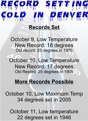
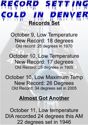
Cold weatherTwo days in a row Denver has set or tied record low temperatures. 

On Friday at 5:55am the temperature at Denver International Airport dropped to 26 degrees easily setting a new low temperature record for October 2nd. The previous record of 30 degrees was set in 1999 and also in 1959.  This was the first freeze of the season.  Thornton however remained above the freezing mark with a low of 33.1 degrees.

Following on yesterday’s record setting cold, the Mile High City tied a 109 year old low temperature record this morning. The temperature at Denver International Airport dipped to 31 degrees tying the record low for this date last set in 1900.  Unlike yesterday, Thornton was actually cooler than the official Denver temperature having recorded a low of 28.2.

The average date of Denver’s first freeze is October 7th so we are a bit ahead on timing. The earliest date Denver has received freezing temperatures is September 8th which occurred in 1962. The latest date was in 1944 when the mercury didn’t dip to freezing until November 15th.

For a look at Denver’s cold weather statistics click here.

Preview of Thornton’s October Weather – Fall is Here

What does October weather hold for Denver?

With the first full month of fall here, October usually brings one of the quietest weather months in the Denver area with plenty of mild, sunny days and clear, cool nights. The month actually has our second highest amount of sunshine with 72 percent with September having the most with 74 percent. Interestingly enough, the month following, November, is one of the lowest sunshine months with only 64 percent. Typically October brings our first real taste of winter with the first freeze on average coming on the 7th of the month and the first snow on the 15th of the month.

Average temperatures in October steadily drop throughout the month. On the first we average 72 degree highs but by the 31st that drops to 59 degrees. October also sees our average low temperatures start to reach below freezing as well. At the start of the month we will average 42 degrees as the low temperature but by the end of the month the mercury dips to 30 degrees. This truly begins the sign that winter is approaching.

Get all the details on Denver’s October weather in our complete preview here.

ThorntonWeather.com featured on the City of Thornton’s cable channel

ThorntonWeather.com logoThorntonWeather.com has been featured on the City of Thornton’s cable access channel show Thornton 360.  The interview which was conducted in June 2009 features the site’s chief amateur meteorologist Tony Hake discussing the features of ThorntonWeather.com, his interest in the weather and more.

Be sure to check out the video below and let us know what you think.  You can also watch it on channel 8 throughout the month of September if you have Comcast cable TV.

ThorntonWeather.com would like to thank the City of Thornton’s Communications Department for their work.  Oftentimes we forget how many people it takes to make a city of over 100,000 residents run as well as Thornton does and the city’s employees continually perform above and beyond! 

On to the show:

The Climate Change Examiner – The place for climate change news

The Climate Change Examiner is the place for a complete look at climate change, global warming and the environment.

We are pleased to announce the launch of the Climate Change Examiner! ThorntonWeather.com’s chief amateur meteorologist has been with Examiner.com since the day they launched in 2008 as the Denver Weather Examiner. Starting immediately Tony will also be Examiner.com’s Climate Change Examiner focusing specifically on one of the hottest topics of today (pun intended).

We have discussed climate change and global warming extensively in these pages and in the Denver Weather Examiner and will continue to do so as residents of Colorado are as concerned about climate change as anyway. However, the Climate Change Examiner will cover the topic much more frequently and with greater depth.

Is man the driving factor in global warming? Or is it something else, like the sun, as other say? What are the political issues in this debate? In a fragile economy, how can we afford to do what some say needs to be done? How will a changing climate impact humans and our life on the planet?

The Climate Change Examiner will look at both sides of the issues. I firmly believe that knowledge is key in order to make an educated opinion about any issue and that includes listening to those you are inclined to believe and those you are not. We must understand all sides of the issue if we are to make the right decisions not only for today and the immediate future but also for our longtime survivability.

So let’s begin that journey down the road of greater understanding and with that knowledge, gain an appreciation for Mother Earth and hopefully make the right decisions for her and for us! Check back tomorrow on the Climate Change Examiner’s pages for the start of a series of articles laying out the basics of climate change.

Click here to view the Climate Change Examiner’s pages.

Also look for the Climate Change Examiner on Twitter and Facebook:

September 27 to October 3 – This week in Denver weather history

September 27 to October 3 - This week in Denver weather history

With the end of summer and the arrival of fall, looking back at Denver weather history we start to see more mentions of snow.  It is of course not the only notable weather event this time of year.  We still have received severe thunderstorms, damaging winds, and 90 degree plus heat.

From the National Weather Service:

From the 25th to the 27th:

in 1996…an early season snowstorm brought heavy snow to the Front Range eastern foothills.  Snowfall totals included:  8 to 12 inches around Conifer…7 inches on Floyd Hill…and 6 inches at both bailey and Chief Hosa. Snowfall totaled only 4.7 inches at the site of the former Stapleton International Airport.  This was the first measurable snow of the season.  After the passage of a strong cold front…north winds gusted to 38 mph at Denver International Airport on the 25th.

From the 26th to the 28th: 

In 1936…the heaviest snowfall ever recorded in September and the heaviest snowfall ever recorded so early in the season dumped a total of 16.5 inches of snow on downtown Denver and 21.3 inches at Denver municipal airport.  The 15.0 inches of snow measured from 6:00 pm on the 27th to 6:00 pm on the 28th is the greatest 24 hour snowfall ever recorded in September.  This was the first snow of the season.  The snow was intermittent through the 26th…but continuous from early afternoon on the 27th to around midnight on the 28th…except for a period of rain during the afternoon of the 28th which contributed to a loss of depth on the ground.  The greatest snow depth on the ground downtown was 13 inches with 8 inches at Denver municipal airport.  There were no high winds with the storm and traffic was interrupted for only a short period.  The storm produced property damage estimated at 7 million dollars.  With trees and shrubs in full foliage…the leaves caught and held the heavy water-laden snow…until the branches snapped from the weight.  More than 3000 workmen were called to remove the debris and snow from the city.  The city firemen who were off duty…as well as all the reserves… Were asked to report to their stations.  All schools in the city remained open…but attendance was only 50 percent of normal.  Grade school students were sent home at noon on the 28th.  The early storm caught stockmen with many cattle still in higher ranges.  Warm weather followed the snow…which had all melted by the end of the month…except for a few inches in sheltered places.

On the 27th:

In 1877…smoke from heavy forest fires in the mountains spread over the city on upper wind currents.
 
In 1935…the first snow of the season was 2.8 inches in downtown Denver.  The low temperature dipped to 31 degrees for the first freeze of the season.

Continue reading September 27 to October 3 – This week in Denver weather history

Summer 2009 in review – The summer of storms

This funnel cloud was seen from the Thornton Civic Center (looking north) on June 10th.  Image courtesy Lisa Wilson, the City of Thornton.
This funnel cloud was seen from the Thornton Civic Center (looking north) on June 10th. Image courtesy Lisa Wilson, the City of Thornton.

As summer 2009 comes to a close, it is perhaps most fitting that fall arrives with nearly winter-like weather. We ushered in the summer a month early with a record setting high temperature and soon followed that up with a near constant stream of severe weather for weeks. In fact, most of the events during what was a very active summer season actually occurred in the weeks leading up to the official start of summer.

Even though the official start of summer was a month away, May 19th seemed to be an unofficial start as the mercury climbed to 90 degrees that day setting a new record for the date. The very next day in perhaps what was a sign of things to come, a tornado touched down in Mesa County – only the ninth to strike in that county since 1950.

On May 24th, the first of many severe weather days arrived bringing rain totals of more than an inch to some areas of the Front Range and a funnel cloud over Aurora. As the afternoon progressed the severe weather continued and three tornadoes had been reported in the metro area.

After a couple weeks of relative calm, the severe weather once again appeared and on June 7th funnel clouds and tornadoes seemed to be appearing everywhere. From the north metro area in Broomfield to Aurora, most of the Front Range had some sort of direct severe weather threat. Most notably,the Southlands Shopping Center was struck by an EF1 tornado where extensive damage to the mall occurred.

There's more to this story on the Denver Weather Examiner's site!All of that was only a start to what was a very eventful summer for Thornton and Denver!  Read the rest of this story on Examiner.com!

Flooding in southeastern U.S. claims eight lives

A washed out bridge is shown Monday, Sept. 21, 2009 in Douglasville, Ga. Heavy rain caused flooding in and around the Atlanta area. (AP Photo/John Bazemore)

The governor of Georgia issued a state of emergency on Tuesday morning as the death toll from flooding in the area continued to climb. Some areas near Atlanta reported up to 20 inches of rain in recent days as creeks and rivers ran over their banks flooding entire communities and even sending the Six Flags Over Georgia amusement park under water (see slideshow on Examiner.com).

Adding to the tally of lives lost was a 15-year-old boy whose body was found in the Chattooga River Tuesday morning. In a heart wrenching story, in Carroll County, Georgia a 2-year-old boy perished when he was ripped from his father’s arms as the father struggled against floodwaters.

There is much more to this story on Examiner.com.  Get all the details on the tremendous flooding and view photos and video.
There's more to this story on the Denver Weather Examiner's site!

September 20 to September 26 – This week in Denver weather history

September 20 to September 26 - This week in Denver weather history

Looking back at this week in Denver history we start to see more of the signs that summer is coming to an end and fall and winter are right around the corner.  Summer-like severe weather can still occur but we also start to see more cold temperatures and occasions with snow become more prevelant.

From the National Weather Service:

20   

In 1921…an apparent Bora produced northwest winds sustained to 44 mph with gusts to 64 mph.
 
In 1955…hail stones 1/2 to 3/4 inch in diameter were reported across parts of the city of Denver.
 
In 1992…weather observers at Buckley Air National Guard base sighted two tornados southeast of the base.  The tornados were short-lived and caused no injuries or damage.

20-21

In 1963…heavy rain and hail caused local flooding in southeast Denver.  Thunderstorm rainfall was only 0.60 inch at Stapleton Airport on the 20th.
 
In 1983…the cold front on the 19th brought an unusually cold air mass into metro Denver for so early in the season.  The temperature dipped to a daily record minimum of 28 degrees on both days.
 
In 1995…a vigorous late summer storm brought the season’s first heavy snow to portions of metro Denver.  Millions of trees were damaged and power lines downed as 4 to 8 inches of heavy wet snow settled on fully leafed trees in the Boulder and Denver areas.  Branches snapped and trees split under the weight of heavy snow…downing power lines. Firefighters responded to numerous transformer fires. Around 100 thousand people were left without electricity in Boulder and Denver areas alone.  It took over a week to fully restore power to some areas.  Insurance claims were estimated to be around 6 million dollars to homes in metro Denver and about 500 thousand dollars in damage to automobiles.  It was estimated that about 80 percent of 125 million dollars worth of city owned trees in Denver were damaged.  Snowfall totaled 7.4 inches at the site of the former Stapleton International Airport where the greatest depth of snow on the ground was only 4 inches due to melting.  Temperature records were set on the 21st when the thermometer dipped to a record low reading of 27 degrees and climbed to a high of only 36 degrees… Setting a record low maximum for the date.  North winds gusted to 29 mph at Denver International Airport on the 20th.

Continue reading September 20 to September 26 – This week in Denver weather history

National Weather Service weather balloon zaps Thornton boy

Hundreds of weather balloons like this are released daily by the National Weather Service. (NOAA)

A 12-year-old boy reportedly received a bit of a shock when he touched a National Weather Service balloon that had landed near Niver Creek Middle School in Thornton. The balloons which are launched twice daily from the old Stapleton International Airport facility and other locations across the nation are essential instruments for forecasters.

The boy complained of numbness in his hands after touching it and school officials called the fire department as they were unsure what the device was. Upon closer inspection they read the labels that said the unit belonged to the National Weather Service and was a weather instrument. The boy was transported to a hospital as a precaution and his father told Channel 7 Wednesday morning that he was fine.

Weather balloons are launched daily from 102 locations across the United States, Caribbean and Pacific and are essential forecasting instruments (see below for a map of sites in the contiguous United States). The six foot diameter balloons are launched twice daily and simultaneously at all the sites at midnight UTC and noon UTC (5:00am MDT and 5:00pm MDT). Once launched, the units can attain an altitude of 115,000 feet and travel up to 200 miles before they burst and fall harmlessly to the ground.

Called a radiosonde, the balloon’s payload measures air pressure, temperature, humidity, wind direction and wind speed. The data is transmitted in real time to receivers on the ground which is then fed into National Weather Service computers and monitored by forecasters. Information obtained by the units is essential for forecasters to evaluate and predict atmospheric conditions for forecasting, severe weather alerting and more.

For more details on what these instruments are used for, read the full story on Examiner.com.

There's more to this story on the Denver Weather Examiner's site!

Weather, natural disasters & climate news and information.