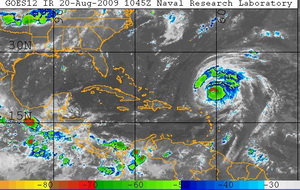
Following on Tropical Storms Ana and Bill, watch for Claudette

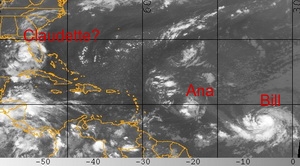
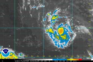
Tropical Storms Ana and Bill formed Saturday.  The National Hurricane Center expects a tropical depression off of the coast of Florida to become Tropical Storm Claudette today.
Tropical Storms Ana and Bill formed Saturday. The National Hurricane Center expects a tropical depression off of the coast of Florida to become Tropical Storm Claudette on Sunday.

Following on the first two named storms of the 2009 Atlantic hurricane season forming Saturday, a third may form off the coast of Florida today. Tropical Storm Ana, the first of the season, formed early Saturday. This was followed by Bill later in the day. Today the National Hurricane Center is forecasting that a tropical depression near Florida will reach tropical storm strength by the end of the day and if so, will be assigned the name Claudette.

Tropical Depression Four is currently 90 miles west-southwest of Tampa, Florida and moving to the north-northwest at 16 mph. With maximum sustained winds of 35 mph, the storm is just below the 39 mph threshold to become a tropical storm.

Strengthening is expected and the NHC predicts the system will become a tropical storm before it hits the coast. In anticipation of this, a tropical storm warning has been issued from the Alabama / Florida border east to the Suwannee River in Florida. Rainfall accumulations from 3 to 5 inches are expected with coastal storm surge of 3 to 5 feet.

For more information:

There's more to this story on the Denver Weather Examiner's site!For complete details on this potential triple threat, read the full story on Examiner.com.

August 16 to August 22 – This week in Denver weather history
August 16 to August 22 - This week in Denver weather history

August is usually considered one of the calmer weather months in Denver but as our look back in weather history for this week shows, that isn’t always the case.  Thunderstorms and all their associated dangers – lightning, flooding, tornadoes and more – all present a very real danger even this time of year.

From the National Weather Service:

16

In 1902…a thunderstorm produced west winds sustained to 48 mph with gusts to 60 mph…but only a trace of rain.
 
In 1952…a thunderstorm wind gust to 50 mph was recorded at Stapleton Airport.
 
In 1960…lightning struck a warehouse in central Denver… Causing 8 thousand dollars in damage to the building and stored electrical equipment.
 
In 1975…large hail…1 1/2 to 1 3/4 inches in diameter…fell about 4 miles north of Castle Rock.  Hail caused some minor damage in Aurora.  A funnel cloud was reported 25 miles east of Denver near Bennett.
 
In 1981…a tornado touched down briefly in open country just to the east of Aurora.  No damage was reported.
 
In 1982…a thunderstorm wind gust to 61 mph was recorded at Buckley Field in Aurora.  At the same time almost an inch of rain flooded and closed streets in south Aurora.  A women was hit by lightning just north of Denver.  A house in the area was also struck.
 
In 1985…a thunderstorm produced strong wind gusts over southern metro Denver.  One strong wind gust hit Cheery Creek Reservoir…capsizing a boat and drowning a man.  The wind gusts…clocked as high as 50 mph…also downed a few trees.
 
In 1989…1 3/4 inch diameter hail fell at Intercanyon in the foothills of Jefferson County.
 
In 1990…lightning caused minor damage to a south Aurora home.  No injuries were reported.
 
In 1994…strong thunderstorm winds caused damage in southern Weld County near Hudson and Fort Lupton.  Two mobile homes were destroyed and a few lost their roofs.  Up to 20 downed power poles and the destruction of two 115 thousand-volt towers caused widespread power outages.  Thunderstorm gust front winds from the north gusted to 48 mph at Stapleton International Airport.
 
In 2000…lightning ripped most of the roof from a home in southeast Aurora.  The bolt sparked a fire which destroyed the residence.  Damage was estimated at 250 thousand dollars.
 
In 2002…the temperature climbed to a maximum of 100 degrees setting a new record high for the date.
 
In 2003…a teenager was injured when he was struck by lightning while camping at Herman Lake…13 miles northwest of Georgetown.  The boy was knocked unconscious and suffered minor injuries.

16-19

In 1979…heavy thunderstorm rains on each of 4 consecutive days dumped a total of 2.62 inches of rain on Stapleton International Airport.  The heaviest rain…1.05 inches… On the 19th was accompanied by 1/4 inch diameter hail.

Continue reading August 16 to August 22 – This week in Denver weather history

Tropical Storm Ana forms in the Atlantic

Tropical Storm Ana has formed in the Atlantic and become the first named storm in that basin of the 2009 season.

The 2009 hurricane season began on June 1st but it wasn’t until this week that the Atlantic basin finally started to really show signs of life. Tropical Storm Ana has formed over the eastern Atlantic becoming that ocean basin’s first named storm of the 2009 season. By contrast, the Pacific basin has had nine storms with Hurricane Guillermo currently being the latest.

The National Hurricane Center says that Tropical Storm Ana is currently 1,010 miles east of the Leeward Islands where a Tropical Storm Watch may be issued later today. The storm is moving west at 16 mph with maximum sustained winds of 40 mph. The NHC says that Ana is expected to strengthen and pick up speed over the next 48 hours.

For more information:

There's more to this story on the Denver Weather Examiner's site!For more details, view the complete story on Examiner.com.

August 9 to August 15 – This week in Denver weather history
August 9 to August 15 - This week in Denver weather history
Denver and Colorado as a whole are known for their unusual weather.  This week in particular is notable for one extraordinary event in weather history – clouds of grasshoppers!

8-10 

In 1979…heavy thunderstorm rains on each of three consecutive days dumped a total of 2.22 inches of rain at Stapleton International Airport.  The heaviest rain… 0.95 inches…fell on the 9th.  Small hail to 1/8 inch diameter fell on the 8th.

8-13 

In 1875…clouds of grasshoppers were seen flying through the air on the prevailing winds during each day.

9    

In 1900…a thunderstorm produced west winds sustained to 47 mph with gusts to 55 mph…but only 0.01 inch of rain.
 
In 1902…a thunderstorm produced no rain and north winds sustained to 52 mph with gusts to 60 mph.
 
In 1934…heavy cloudbursts in the foothills near Kittredge and at the head of Mount Vernon creek caused flash flooding on both bear creek and Mount Vernon Creek at Morrison… Which resulted in 6 deaths and much property damage. The highway in Mount Vernon Canyon was destroyed by the flood waters.
 
In 1981…3/4 inch hail fell at Kittredge near Evergreen in Jefferson County.
 
In 1987…3/4 inch hail fell in Boulder and 9 miles northwest of Castle Rock.
 
In 1995…lightning struck a 16-year-old counselor in the back of the head while he and a friend were standing under a tree at the singing river ranch…7 miles west of Evergreen.  He stopped breathing…but his friend was able to summon help and they were able to revive him.  He was hospitalized for a few days and released.
 
In 1998…brief…weak tornadoes (f0) were sighted near Bennett and Roggen.  No damage was reported.  Hail as large as 1 inch diameter fell in Franktown with 3/4 inch diameter hail measured near Castle Rock. Thunderstorm winds gusted to 61 mph near Roggen.

Continue reading August 9 to August 15 – This week in Denver weather history

August 2 to August 8 – This week in Denver weather history
August 2 to August 8 - This week in Denver weather history

On first glance our look at this week in Denver weather history appears to be less eventful than many we have looked at previously.  However, the severity of the events that appear on the historical weather calendar this week are enough to make you stand up and pay attention.  While August is typically a pretty quiet weather month, it is clear that severe weather can certainly strike and Thornton is mentioned in more than one significant event.

From the National Weather Service:

2    

In 1878…the high temperature reached 100 degrees in downtown Denver.
 
In 1911…an apparent dry microburst produced sustained west winds to 42 mph.
 
In 1972…one workman was killed and another injured when a strong gust of wind destroyed a partially completed apartment building in south Denver.  Hail to 1 3/4 inch diameter fell in Golden.
 
In 1973…hail to 3/4 inch diameter was reported in Boulder.
 
In 1986…a major outbreak of severe thunderstorms occurred along the Front Range.  Thunderstorms developed explosively.  Some places were hit by large hail twice. Two inch diameter hail broke car windows on I-25 west of Brighton…and up to 1 1/4 inch hail broke windows in Thornton.  Baseball size hail damaged several planes near Watkins.  Funnel clouds were sighted around Aurora.  Hail over 1/2 inch in diameter covered the ground 3 to 4 inches deep at Hudson northeast of Denver.  Most of the hail fell north of metro Denver…but 3/4 inch diameter hail was measured at Stapleton International Airport.  Total damage from the hail storms this day was estimated at over 10 million dollars.
 
In 1991…late afternoon thunderstorms produced heavy rain across metro Denver.  Two feet of water covered parts of I-25 in southeast Denver…while one foot of water covered parts of U.S. Highway 285 in Englewood.  Thunderstorm rainfall totaled 0.50 inch at Stapleton International Airport.
 
In 2001…severe thunderstorms producing heavy rain and hail… Either washed out or damaged several County roads in the Watkins and Bennett areas.  A small tornado (f0) touched down near Bennett…but did no damage.  Hail as large as 1 3/4 inches in diameter fell near Watkins.  One inch diameter hail was measured near Hudson and Keenesburg.
 
In 2008…strong winds blew several trees down in Denver… Damaging homes and downing power lines.  A peak wind gust of 67 mph occurred at Centennial Airport…with gusts to 60 mph estimated in Denver.  A peak wind gust of 37 mph was measured at Denver International Airport.  An elderly man was killed when a wind damaged tree broke free and crushed him while he attempted to remove it.  The downed power lines caused outages to about 500 Xcel energy customers.

Continue reading August 2 to August 8 – This week in Denver weather history

A new record low maximum temperature set & snow comes to the mountains

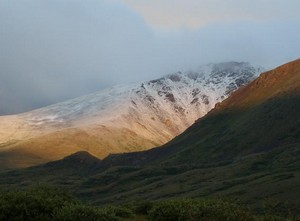
Denver has record setting cool temperatures and snow arrives in the Rocky Mountains.  Image courtesy Victor Lewis.
Denver has record setting cool temperatures and snow arrives in the Rocky Mountains. Image courtesy Victor Lewis.

While some parts of the nation experience record setting heat, on Thursday Denver had the opposite problem. The high temperature as measured at Denver International Airport reached a mere 64 degrees. This was two degrees below the previous record low maximum temperature of 66 degrees for this date set in 1925 and previous years. That is also an amazing 24 degrees below the normal temperature for this time of year!

Here in Thornton, we were even cooler than the official temperature on Thursday as the mercury climbed to a mere 61.3 degrees! 

The unseasonably cold weather has also brought an unusual sight to the Colorado mountains in July – snow! Some northern parts of the Rocky Mountains in the state above 12,000 feet received a couple inches of snow.

Climate change to bring more wildfires to the Rockies

Atmospheric scientists claim the potential for a 50% increase in wildfire activity due to global warming. (AP Photo)

Sounding the warning sirens about the potential repercussions of global warming, Harvard scientists announced their belief that the changing climate will result in a 50% increase in the amount of land burned by wildfires by 2050.  Should the predictions come true, the increased smoke from an increase in fires could have the effect of further accelerating warming.

Atmospheric scientists from Harvard’s School of Engineering and Applied Sciences (SEAS) have generated models that show much of the western half of the United States being at much greater risk from wildfires.  The study, published in the Journal of Geophysical Research, is said to be the first to measure the impact of future wildfires on air quality.

SEAS Senior Research Fellow Jennifer Logan said, “Warmer temperatures can dry out underbrush, leading to a more serious conflagration once a fire is started by lightning or human activity.  Because smoke and other particles from fires adversely affect air quality, an increase in wildfires could have large impacts on human health.”

There's more to this story on the Denver Weather Examiner's site!For all the details on this study and what it means to Colorado and the Rocky Mountain Region, check out the full story on Examiner.com.

Denver storm costs $350 million – Second most in state history

A man surveys damage to a vehicle struck by a fallen tree after last week's storms. The June 20th hail and wind storm has racked up costs of $350 million in insurance claims.  Image courtesy Becki Mullen.
A man surveys damage to a vehicle struck by a fallen tree after last week's storms. The June 20th hail and wind storm has racked up costs of $350 million in insurance claims. Image courtesy Becki Mullen.

Last week’s hail and wind storm that brought destruction to the west Denver suburbs of Wheat Ridge and Arvada caused $350 million in insured damage according to the Rocky Mountain Insurance Information Association (RMIIA).  The end result is a storm that now ranks as the second costliest in state history and adds to an already expensive summer storm season.

The July 20th storm has thus far resulted in 52,400 claims, 19,500 of which were for automobile damage and 32,900 were homeowner claims.  RMIIA says that damage would have been much higher had the storm struck during daylight hours when more people and vehicles were on the road instead of in their homes and garages. 

Massive trees were uprooted, power poles snapped, windows shattered, and automobiles dented beyond repair when the storm brought winds in excess of 60 mph and golf ball sized hail to the area.  Two tornadoes also briefly touched down near Castle Rock and Englewood although they were not responsible for significant damage.  90,000 people lost power during the storm and Xcel Energy deployed more than 200 people into the field to restore electricity. 

There's more to this story on the Denver Weather Examiner's site!For all the details, including amazing images and video of the damage, view the complete story on Examiner.com.

August 2009 climate and weather preview posted

Thorntons August weather preview.
Thornton's August weather preview.

As summer vacations wind down and families prepare to send their kids back to school in August, Colorado weather also starts to settle down. The chances for severe weather decrease markedly during August and by the end of the month daytime temperatures are dropping quite a bit as well.

At the start of the month Denver usually averages around 88 degrees for a high temperature. By the end of August that drops to 82 degrees. Similarly, nighttime lows drop from 60 to 53 from the start to the end of the month. Generally clear skies can be expected between midnight and noon but the afternoon often brings showers and thunderstorms. These storms typically develop over the foothills then bring precipitation to the Denver metro area.

Despite that moisture, the chance for severe weather decreases considerably compared to the first two months of summer. Cooler air near the surface helps to create a stable atmosphere thus keeping thunderstorms from usually becoming too intense. After the middle of August, tornadoes and damaging hail are pretty rare. The slow movement of storms this time of year are more likely to produce potentially heavy rain.

Click here to read the complete preview including a look back at what was a record setting month last year.

Study: Nature responsible for global warming, not man

A new study says he El Niño-Southern Oscillation (ENSO) accounts for the vast majority of temperature variability.

A new peer-reviewed study calls into question the so-called ‘consensus’ on the causes of global warming by saying that “Nature, not man, responsible for recent global warming.”  The new study authored by three Australian scientists and published in the Journal of Geophysical Research says that the El Niño-Southern Oscillation (ENSO) accounts for the vast majority of temperature variability.

Authored by Chris de Freitas (University of Auckland in New Zealand), John McLean (Melbourne) and Bob Carter (James Cook University), the new study is sure to cause waves among those debating the causes of global warming.  Completely contrary to the mainstream media’s portrayal of climate change, the study says, “little or none of the late 20th century global warming and cooling can be attributed to human activity.”

Lead author de Freitas said in a press release, “The surge in global temperatures since 1977 can be attributed to a 1976 climate shift in the Pacific Ocean that made warming El Niño conditions more likely than they were over the previous 30 years and cooling La Niña conditions less likely.”

Weather, natural disasters & climate news and information.