January 18 to January 24 – This week in Denver weather history

January 18 to January 24 - This week in Denver weather history.

Our look back in Denver weather history for this week is dominated by the seemingly ever present high winds.  There are numerous incidents of those causing damage and injury.  Also notable though was a snowstorm in 1948 that dumped snow for more than 92 hours straight, a protracted cold spell in 1962 that lasted nearly a week and claimed lives and more recently the snowstorms in January 2007 that dumped snow on the region.

14-21

IN 1930…A PROTRACTED COLD SPELL OCCURRED WHEN LOW TEMPERATURES PLUNGED BELOW ZERO ON 8 CONSECUTIVE DAYS.  THE COLDEST LOW TEMPERATURES OF 20 DEGREES BELOW ZERO ON THE 17TH AND 19 DEGREES BELOW ZERO ON THE 16TH WERE RECORD MINIMUMS FOR THE DATES.  HIGH TEMPERATURES DURING THE PERIOD RANGED FROM 18 ON THE 18TH TO ZERO ON THE 20TH.  TWO DEGREES ON THE 15TH WAS A RECORD LOW MAXIMUM TEMPERATURE FOR THE DATE.

15-23

IN 1962…A PROTRACTED COLD SPELL KEPT METRO DENVER IN THE DEEP FREEZE FOR MORE THAN A WEEK.  FROM THE 15TH THRU THE 23RD…LOW TEMPERATURES WERE ZERO OR BELOW FOR 9 CONSECUTIVE DAYS…BUT A DAILY RECORD LOW WAS SET ONLY ON THE 22ND WHEN THE TEMPERATURE DIPPED TO 14 DEGREES BELOW ZERO.  A RECORD LOW MAXIMUM FOR THE DATE WAS ALSO SET ON THE 22ND WHEN THE TEMPERATURE CLIMBED TO ONLY 11 DEGREES.  THE COLDEST HIGH TEMPERATURE WAS 3 DEGREES ABOVE ZERO ON THE 21ST…WHICH DID NOT BREAK THE RECORD.  THE PROTRACTED COLD WAS BROKEN FOR ONLY A FEW HOURS ON THE AFTERNOON OF THE 20TH WHEN CHINOOK WINDS WARMED THE TEMPERATURE TO A HIGH OF 38 DEGREES BEFORE ANOTHER SURGE OF COLD ARCTIC AIR PLUNGED TEMPERATURES BACK INTO THE DEEP FREEZE THAT EVENING.  THE SEVERE COLD CAUSED MUCH DAMAGE TO WATER SYSTEMS.  A WOMAN WAS FROZEN TO DEATH AT MORRISON.  THERE WERE OTHER DEATHS ATTRIBUTABLE TO THE WEATHER…INCLUDING TRAFFIC DEATHS AND HEART ATTACKS FROM OVEREXERTION.

16-18

IN 1943…LIGHT SNOWFALL TOTALED 3.2 INCHES OVER THE 3 DAYS. THIS WAS THE ONLY MEASURABLE SNOW OF THE MONTH.  NORTH WINDS WERE SUSTAINED TO 20 MPH ON THE 16TH.

17-18

IN 1974…RARE OVERNIGHT JANUARY RAINFALL TOTALED 0.12 INCH ON THE 17TH AND 0.26 INCH ON THE 18TH WHEN IT WAS BRIEFLY MIXED WITH SNOW.

Continue reading January 18 to January 24 – This week in Denver weather history

11th annual Storm Chaser Convention coming to Denver

Get ready for ChaserCon - Coming to Denver in February!

The 11th annual National Storm Chaser Convention is coming to Denver from February 13th to the 15th.  Organized by storm chasers Roger Hill and Tim Samaras, this event brings together amateur and professional storm chasers, meteorologists, climatologists and experts from across a wide spectrum dealing with weather.  It is a great opportunity to learn not just about storm chasing but also about the weather in general.

As usual, a great slate of speakers has been lined up including:

More than lectures though, the convention features screening of some of the most incredible tornado footage from the past year as well as a hands-on look at the latest in weather gadgetry.  On the afternoon of the 15th, the National Weather Service will also be holding an official storm spotter training session that is open to the public. 

You can learn more about this great event and see the complete agenda on the convention website at www.chaserconvention.com.

Thornton needs snowbusters!

The City of Thornton is looking for snowbusters to help remove snow for seniors and disabled residents.

Editor’s comment – This is a great way to ‘give back’ to the community and help those who truly need it.  From the City of Thornton:

Winter is coming: Snowbusters needed
Snowbuster volunteers help dig out neighbors in need

THORNTON, CO…Winter is on the way, and while the snow isn’t here yet, Snowbuster volunteers are needed now. Snowbusters is a snow removal program that helps fixed-income seniors and disabled residents who can’t remove snow from their sidewalks. Snowbuster volunteers are paired-up with a neighbor in their area, and when it snows, the Snowbuster goes into action clearing their neighbor’s sidewalk. “These Snowbuster volunteers make a valuable difference in the lives of those in need,” says Thornton Arts and Volunteer Specialist Heather Kailey. “Their work is really appreciated.”

After each storm, Snowbuster volunteers:

  • have 36 hours to shovel their partner’s sidewalks
  • have 48 hours to clear the snow If more than eight inches fall
  • don’t have to worry about driveways, they are not included in this volunteer service

“Snow removal not only provides safe sidewalks for residents, but also for delivery persons and Meals on Wheels staff,” says Kailey. “It’s just a great service for those in need, and it really doesn’t take that much effort from the Snowbuster volunteer.”

Click here for more information.

* ThorntonWeather.com is not endorsed by or an official website of the City of Thornton.

Carbon monoxide claims five lives and sickens dozens this winter

Carbon monoxide poisoning has claimed five lives in Colorado this winter.  The time is now to protect yourself and your family by installing CO detectors.
Carbon monoxide poisoning has claimed five lives in Colorado this winter. The time is now to protect yourself and your family by installing CO detectors.

In recent weeks the dangers of carbon monoxide poisoning have been hitting very close to home here in Colorado.  On November 28th, a family of four in Aspen was killed by the invisible, odorless gas due to a leak in a gas-fired broiler.  Last week on January 5th a University of Denver student was killed in a similar case, possibly from a faulty flue.  This past Saturday more than 30 people in a Greeley hockey rink were treated for CO poisoning when exhaust gases from the ice grooming equipment is believed to have caused dangerous levels of the gas. 

The Colorado state legislature yesterday took up a bill that would mandate detectors in all new homes and in apartment buildings.  While we don’t necessarily believe legislation is the cure, education certainly would go a long ways toward making folks aware of the danger.

The cost of carbon monoxide detectors has dropped appreciably in recent years as they become more popular and now is the time to protect yourself and your home.  Every home should have at least one and indeed, experts recommend you have one on every level of the house. 

An expanded version of this article is available on Examiner.com with more safety tips on how you can protect you and your family from carbon monoxide. Visit Examiner.com for more local Denver news and weather.

The incident in Aspen got my attention and I bought a number of them for my house and highly encourage everyone to do the same.  They can be found at most home improvement stores, big box stores or online at places like Amazon.com.  Installation is very simple with some just needing to be plugged into a wall outlet and others being battery operated.

Winter Weather Advisory issued for the Front Range

Current ThorntonWeather.com webcam image.

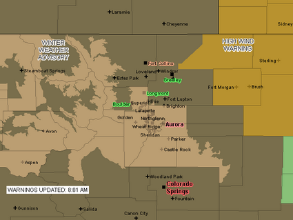
Due to the deteriorating weather conditions, the National Weather Service has issued a Winter Weather Advisory for snow and blowing snow.  Areas under the advisory include the Denver metro area and areas south to Castle Rock as well as some of the mountain areas (see advisory map below).  The storm seems to be lingering over the Front Range longer than expected but the snowfall is still expected to end quickly late this morning.

URGENT – WINTER WEATHER MESSAGE
NATIONAL WEATHER SERVICE DENVER CO
757 AM MST MON JAN 12 2009

..Winter weather advisory in effect until 11 am MST Tuesday…

The National Weather Service in Denver has issued a Winter Weather Advisory for snow and areas of blowing snow…which is in effect until 11 am MST Tuesday.

Snow…heavy at times…will continue within the greater Denver metro area…the southern Front Range foothills and the palmer divide south of Denver. A band of moderate to heavy snow now over the Denver metro area will continue to move south over the palmer divide south of Denver within the next hour. In addition to snowfall…areas of blowing snow will significantly reduce visibilities at times.

Snowfall is expected to taper off rather quickly later this morning…first over the northern Denver metro area and then eventually over the palmer divide and southern foothills by early this afternoon.

Additional snow accumulations by noon today will range from 1 of 3 inches in Boulder and across the northern Denver suburbs to another 3 to
6 inches in the southern Denver and over the palmer divide.

In addition…north winds of 15 to 25 mph will produce areas of blowing snow and very poor visibilities especially over the higher terrain south and southeast of Denver.

A winter weather advisory means that snow…blowing snow…or freezing drizzle will cause travel difficulties. Be prepared for slippery roads and limited visibilities…and use caution while driving.

A Winter Weather Advisory is in effect for much of the Front Range until 11:00am Monday.

January 11 to January 17 – This week in Denver weather history
January 11 to January 17 - This week in Denver weather history

Damaging wind storms and arctic cold dominate our look back at this week in Denver weather history.

From the 10th to the 11th: 

IN 1948…STRONG WINDS WERE REPORTED IN BOULDER AND LAKEWOOD. WINDS OF 50 TO 60 MPH WERE REPORTED AT VALMONT…JUST EAST OF BOULDER.  ONLY MINOR DAMAGE WAS REPORTED.

IN 1980…STRONG WINDS OF 60 TO 95 MPH HOWLED ACROSS METRO DENVER…CAUSING SOME BRIEF POWER OUTAGES AND SOME BROKEN WINDOWS.  A WIND GUST TO 111 MPH WAS RECORDED AT WONDERVU. NORTHWEST WINDS GUSTED TO 40 MPH AT STAPLETON INTERNATIONAL AIRPORT ON THE 10TH.

IN 1999…HIGH WINDS GUSTING TO 100 MPH BLASTED THE FOOTHILLS. PEAK WIND GUSTS INCLUDED:  100 MPH AT CENTRAL CITY…98 MPH AT WONDERVU…82 MPH AT ASPEN SPRINGS AND GOLDEN GATE CANYON… 81 MPH AT THE NCAR MESA LAB IN BOULDER AND NEAR NEDERLAND… 78 MPH ATOP BLUE MOUNTAIN NEAR COAL CREEK CANYON…AND 72 MPH AT THE ROCKY FLATS ENVIRONMENTAL TEST FACILITY.  WEST WINDS GUSTED TO 38 MPH AND WARMED THE TEMPERATURE TO A HIGH OF 63 DEGREES AT DENVER INTERNATIONAL AIRPORT ON THE 11TH.

From the 10th to the 12th: 

IN 1997…HEAVY SNOW FELL OVER THE FRONT RANGE FOOTHILLS. A FOOT OF NEW SNOW WAS MEASURED AT BLACKHAWK WITH 7 INCHES RECORDED IN COAL CREEK CANYON.  ONLY 3.3 INCHES OF SNOW FELL AT THE SITE OF THE FORMER STAPLETON INTERNATIONAL AIRPORT.  EAST-NORTHEAST WINDS GUSTED TO 18 MPH AT DENVER INTERNATIONAL AIRPORT ON THE 11TH.

Continue reading January 11 to January 17 – This week in Denver weather history

Lots of new features including ski reports, live traffic conditions and more

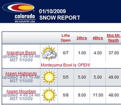
Ski condition reports are just one of the many new features recently added to ThorntonWeather.com.

ThorntonWeather.com is just like the Colorado weather – we are constantly changing!  In recent weeks we have added a number of features that we are sure everyone will appreciate from ski condition reports to Denver traffic conditions to national radar and maps.  Some of the new additions include:

  • Added the Colorado Ski Conditions from Colorado Ski Country USA.  It is available under the Live Conditions menu on the left. 
  • Modified the Weather Maps page to start off showing the approaching systems (vice radar).  Also changed the selection menu at the bottom of the page to show regional information on top.
  • Added a National Maps page and menu item under the Radar & Maps menu. 
  • Added a Colorado Road Conditions page with current state highway conditions from CDOT.  Available from the Live Condtions menu on the left.
  • Added a live Denver traffic map from Traffic.com.  Available from the Live Condtions menu on the left.
  • Added a number of national weather maps from the Weather Channel.  These are available under the Radar & Maps menu on the left and include:

For a complete log of site changes, you can view our Website Change Log here.

Do you have a suggestion for something you would like to see us add?  Do you have any other comments, questions or criticisms?  Use the comment feature below and let us know what you think!

NASA says global warming will increase severe storms

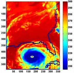
Extremely high clouds, known as deep convective clouds, are typically associated with severe storms and rainfall. In this AIRS image of Hurricane Katrina, taken August 28, 2005, the day before Katrina made landfall in Louisiana, the eye of the storm was surrounded by a "super cluster" of 528 deep convective clouds (depicted in dark blue). The temperatures of the tops of such clouds are colder than 210 degrees Kelvin (-82 degrees Fahrenheit). Image credit: NASA/JPL

Scientists are NASA’s Jet Propulsion Laboratory in Pasadena, CA recently released the results of a study that determined that global warming is causing an increase in high clouds and a corresponding increase in severe storms and rainfall.  This is not unlike previous warnings issued by some scientists, in particular those warnings of an increase in hurricane intensity and frequency in the Atlantic.  Thus far those previous warnings have not bore out.  Will this one? 

Here are the details on the new study:

From:  NASA / JPL
December 19, 2008

PASADENA, Calif. — The frequency of extremely high clouds in Earth’s tropics — the type associated with severe storms and rainfall — is increasing as a result of global warming, according to a study by scientists at NASA’s Jet Propulsion Laboratory, Pasadena, Calif.

In a presentation today to the fall meeting of the American Geophysical Union in San Francisco, JPL Senior Research Scientist Hartmut Aumann outlined the results of a study based on five years of data from the Atmospheric Infrared Sounder (AIRS) instrument on NASA’s Aqua spacecraft. The AIRS data were used to observe certain types of tropical clouds linked with severe storms, torrential rain and hail. The instrument typically detects about 6,000 of these clouds each day. Aumann and his team found a strong correlation between the frequency of these clouds and seasonal variations in the average sea surface temperature of the tropical oceans.

For every degree Centigrade (1.8 degrees Fahrenheit) increase in average ocean surface temperature, the team observed a 45-percent increase in the frequency of the very high clouds. At the present rate of global warming of 0.13 degrees Celsius (0.23 degrees Fahrenheit) per decade, the team inferred the frequency of these storms can be expected to increase by six percent per decade.

Climate modelers have long speculated that the frequency and intensity of severe storms may or may not increase with global warming. Aumann said results of the study will help improve their models.

“Clouds and rain have been the weakest link in climate prediction,” said Aumann. “The interaction between the daytime warming of the sea surface under clear-sky conditions and increases in the formation of low clouds, high clouds and, ultimately, rain is very complicated. The high clouds in our observations—typically at altitudes of 20 kilometers (12 miles) and higher—present the greatest difficulties for current climate models, which aren’t able to resolve cloud structures smaller than about 250 kilometers (155 miles) in size.”

Aumann said the results of his study, published recently in Geophysical Research Letters, are consistent with another NASA-funded study by Frank Wentz and colleagues in 2005. That study found an increase in the global rain rate of 1.5 percent per decade over 18 years, a value that is about five times higher than the value estimated by climate models that were used in the 2007 report of the Intergovernmental Panel on Climate Change.

JPL manages the AIRS project for NASA’s Science Mission Directorate, Washington. For more information on AIRS, visit http://airs.jpl.nasa.gov/ .

JPL is managed for NASA by the California Institute of Technology in Pasadena.

Batten down the hatches – here comes the wind again

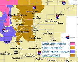
Much of the western and northern Front Range will be under a High Wind Watch starting tonight.

The relative calm of recent days is about to be replaced with high winds not unlike what we saw last week.   Winds will increase tonight and continue through Wednesday east of the Continental Divide.  Areas west of I-25 to the Divide and in the north and central mountain areas will be under a High Wind Watch from late tonight through Wednesday night. 

Much like last week, the usual suspect areas west of I-25 are the places to watch.  Fort Collins, Boulder and the western suburbs of Denver are going to get the worst of the wind.  The Peak to Peak Highway, Highway 287 north of Fort Collins, the Boulder Turnpike west of Broomfield, and Highway 93 between Boulder and Golden are naturally going to be prime targets. 

Wind gusts in excess of 80 mph can be expected in these areas but as we saw last week, other parts of the metro area can receive their fair share of wind as well.  As usual, it is best to put away anything in your yards that could be become a missile and if you are driving in the high wind areas, particular along a north / south route, be prepared for extremely gusty conditions.

Get more local news and weather information on Examiner.com.
This article and many more are posted to the Denver Weather Examiner site.
Visit Examiner.com for more local Denver news and weather.

The good news is that the downslope winds will also bring warmer temperatures – not that you will want to be outside in the wind.  Wednesday we will be well above normal with temperatures in the mid 50’s and Thursday could reach the low 60’s.  There is a slight chance of snow Friday but that isn’t looking to amount to much.

2008 had second highest number of tornadoes on record

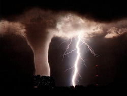
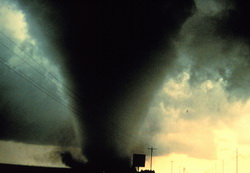
2008 will go down as the second most active year for tornadoes on record.

According to the latest data from the Storm Prediction Center, the number of confirmed tornadoes in 2008 will finish well above average.  Final numbers through the end of October count 1,621 twisters, exceeding the average over the last ten years of 1,270 per year. 

Once the data is finalized, the year will most likely go down as the second most active tornado year on record since record keeping began in 1950.  2004 was the most active year with 1,871 and the number three year was 1998 with 1,424. 

While some alarmists may look to climate change as a reason for what seems to be an increase in the number of twisters, the explanation is actually much simpler than that.  Technology like radar now allows us to ‘see’ tornadoes in rural areas that normally would have gone unreported.  Further, as population grows, there are simply more people living in areas that were unpopulated before and thus twisters are spotted more often. 

Get more local news and weather information on Examiner.com.
This article and many more are posted to the Denver Weather Examiner site.
Visit Examiner.com for more local Denver news and weather.

What about Colorado?  Certainly we all remember the Windsor tornado in May.  Beyond that, there were a total of 61 tornado reports in 2008.  The actual number of twisters will certainly be lower than that once duplicate reports are removed and the tally is official.

TORNADO TOTALS AND RELATED DEATHS...THROUGH 12/31/2008
NWS STORM PREDICTION CENTER NORMAN OK
0726 AM CST THU JAN 01 2009

    ...NUMBER OF TORNADOES...            NUMBER OF        KILLER
                                       TORNADO DEATHS    TORNADOES
     ..2008..  ..2007.. 2006 2005  3YR            3YR            3YR
    PREL  ACT PREL  ACT  FIN  FIN   AV 08 07 06 05 AV 08 07 06 05 AV
JAN  136   84   29   21   47   33   34  7  2  1  4  2  4  1  1  2  1
FEB  230  148   87   52   12   10   25 59 22  0  0  7 12  3  0  0  1
MAR  150  126  214  171  150   62  128  4 27 11  1 13  3 10  7  1  6
APR  189  189  187  165  245  132  181  0  9 38  0 16  0  3  9  0  4
MAY  597  460  282  250  139  123  171 43 14  3  0  6 10  4  1  0  2
JUN  394  289  152  128  120  316  188  7  0  0  0  0  4  0  0  0  0
JUL  120   94   55   69   71  138   93  1  0  0  0  0  1  0  0  0  0
AUG  145   99   87   73   80  123   92  0  1  1  4  2  0  1  1  3  2
SEP  133  111   63   51   84  133   89  2  0  1  1  1  1  0  1  1  1
OCT   28   21  115   87   76   18   60  0  5  0  0  2  0  3  0  1  1
NOV   20    -    7    7   42  150   66  2  0 10 28 13  2  0  3  5  3
DEC   50    -   22   19   40   26   33  0  1  2  0  1  0  1  2  0  1
    ----  --- ---- ---- ---- ---- ---- --- -- -- -- -- -- -- -- -- --
SUM 2192 1621 1300 1093 1106 1264 1159 125 81 67 38 62 37 26 25 13 21

PREL = 2009 PRELIMINARY COUNT FROM NWS LOCAL STORM REPORTS.
ACT = ACTUAL COUNT BASED ON NWS STORM DATA SUBMISSIONS.

TORNADO-RELATED FATALITY NUMBERS ARE ENTERED WHEN CONFIRMED BY NWS
FORECAST OFFICES.

Weather, natural disasters & climate news and information.