As summer vacations wind down and families prepare to send their kids back to school in August, Colorado weather also starts to settle down. The chances for severe weather decrease markedly during August and by the end of the month daytime temperatures are dropping quite a bit as well. Find out more about what lies ahead with Thornton’s August weather here.
August 3 to August 9: This Week in Denver Weather History
As we enter August we start to see a decrease in severe weather. However, as our look back at this week in Denver weather history shows, extreme events can and do still occur. Heavy, flooding rain, hail and deadly lightning all show on the calendar.
From the National Weather Service:
2-3
In 1876…grasshoppers were in great abundance in the city and caused considerable damage to gardens and to crops in the surrounding farms and ranches.
In 1951…heavy thunderstorms rumbled across metro Denver through the night. Heavy rain totaled 3.45 inches at Stapleton Airport. This was the greatest 24 hour precipitation ever recorded during the month of August in Denver.
In 2007…heavy rain caused localized flash flooding near Ft. Lupton. Up to 8 inches of water was reported across County road 18. In addition…several other County roads in the immediate area were washed out.
3
In 1878…the high temperature climbed to 100 degrees in downtown Denver.
In 1900…a thunderstorm produced west winds sustained to 48 mph with gusts to 55 mph…but only a trace of rain.
In 1903…a thunderstorm produced a trace of rainfall and northwest winds sustained to 45 mph with gusts to 60 mph. The high temperature was 99 degrees.
In 1927…a thunderstorm produced hail and sustained north winds to 22 mph.
In 1933…heavy cloudburst rains caused the failure of the Castlewood Dam…which resulted in flash flooding on Cherry Creek…the deaths of 7 people in Denver…and flood damage estimated at 1 million dollars. Lower Denver was flooded during the morning by waters pouring down Cherry Creek and its valley from Castlewood Dam…which had broken between midnight and 2:00 am. Heavy rain of 3 to 9 inches in 9 hours in the watershed above the dam resulted in the failure. At 7:30 am…the flow in Cherry Creek was reported at 16 thousand second-feet as compared with a peak flow of 3 thousand second-feet in other years. The flood waters ruined hundreds of acres of crops and drowned scores of farm animals. Six bridges in Denver were swept away. Great deposits of mud were left in the lower sections of the city…including hundreds of basements and lower floors of buildings. At the end of the month…a deadly stench still rose from swampy areas near the lower city limits.
In 1963…heavy thunderstorm rains in the Parker area caused Cherry Creek to overflow…which damaged roads.
In 1985…a tornado touched down briefly about 10 miles northeast of Parker. No damage was reported.
In 1991…upslope northeast winds produced chilly temperature readings and heavy rain across metro Denver. Rainfall… With no thunder…totaled 1.56 inches at Stapleton International Airport where the heavy rain briefly reduced the surface visibility to 7/8 mile. The mercury climbed to a high of only 63 degrees.
In 1992…a thunderstorm wind gust to 64 mph was recorded in Brighton. A wind gust to 60 mph was measured near the construction site of the new Denver International Airport. Lightning started a fire in an Evergreen church…causing over 75 thousand dollars in damage.
In 1998…3/4 inch hail fell in Jefferson County 15 miles northwest of Arvada.
In 2006…heavy thunderstorm rainfall caused flash flooding along Leyden Creek in unincorporated Jefferson County. An automated rain gauge on upper Leyden Creek…6 miles northwest of Arvada…measured 2.68 inches of rainfall in less than 2 hours. Two to three feet of water covered the roadway at the intersection of 82nd and Quaker Street.
In 2009…a woman riding her bike…in training for an ironman triathlon…was struck by lightning in Boulder. She was in the 78th mile of a 100-mile training ride when she was hit. The woman lost her vision initially and couldn’t move her arms. After a short stay in the hospital…she made of complete recovery.
3-4
In 1988…two inches of rain fell in 3 hours at both Morrison and Wheat Ridge. Thunderstorm rainfall totaled 0.80 inch overnight at Stapleton International Airport.
4
In 1889…southwest winds were sustained to 42 mph with an extreme velocity to 52 mph.
In 1924…0.01 inch of rain fell over downtown Denver. This along with the 0.01 inch of rainfall on the 10th was the only rainfall of the month…the driest August on record.
In 1963…heavy rains in the foothills above Idaho Springs caused mud and rock slides which closed U.S. Highways 6 and 40 for a time.
In 1976…hail to 1 inch diameter was reported 12 miles southwest of Denver. Hail to 3/4 inch in diameter was reported in Lakewood. Small hail…1/4 to 1/2 inch in diameter…fell at Stapleton International Airport.
In 1982…heavy rain poured through the roof of a clothing store in Aurora…causing widespread water damage. The roof was being repaired when the storm hit.
In 1983…hail up to one inch in diameter fell in Aurora where heavy rain produced street flooding.
In 1984…a Colorado State Trooper was struck and injured by lightning in Northglenn.
In 1989…a microburst wind gust to 52 mph was recorded at Stapleton International Airport.
In 1997…lightning sparked a small fire in a home in Arvada… Causing minor damage. Several intersections in both Arvada and Westminster were flooded by thunderstorms producing heavy rain. Several cars were damaged by the high waters… And a number of businesses were flooded.
In 1999…flooding and flash flooding problems developed over metro Denver as slow moving thunderstorms dumped from 2 to 3.5 inches of rainfall in about 3 hours. Near the junction of I-25 and U.S. Highway 36…up to 4 feet of water flooded an auto dealership. About 45 cars were ruined. Damage estimates to the dealership alone totaled nearly a half million dollars. Sections of I-25 and U.S. 36 near the interchange were closed due to floodwaters. Floodwaters… Up to 5 feet deep…forced the evacuation of two mobile home parks in federal heights. Railroad tracks were washed out near Federal Blvd and 64th Avenue. Numerous power outages caused widespread blackouts in Thornton and Littleton. Along Massey Draw near Carr St. and Chatfield Reservoir…4 homes were flood damaged and portions of their backyards washed out. Widespread street flooding was also reported in Boulder where several buildings were flood damaged…including the University of Colorado memorial center.
In 2004…two golfers were shocked when lightning struck the eighth green of the golf course at castle pines north of Castle Rock. The two men suffered only minor injuries. Heavy thunderstorm rain from the same storm caused flash flooding. Floodwaters rushed across parts of U.S. Highway 85 near the entrance to the castle pines golf club. The traffic lanes were covered with up to 6 inches of running water.
In 2008…lightning sparked a grassfire that consumed 300 acres on the northern edge of Green Mountain…in Jefferson County. Gusty winds and very dry conditions allowed the wildfire to quickly spread and threaten several houses. Fortunately…only minor damage was reported to homes due to smoke and melted siding.
5
In 1881…the low temperature cooled to only 76 degrees…the record high minimum temperature for the month.
In 1889…southwest winds were sustained to 42 mph.
In 1918…hail pelted the city…but was light and caused no damage. Precipitation totaled 0.25 inch. Northwest winds were sustained to 31 mph.
In 1964…lightning struck two boys in Denver while playing ball. One was treated and released from the hospital…but the other boy suffered second degree electrical shock and cardiac arrest and was hospitalized in critical condition for several days.
In 1969…two tornadoes touched down briefly in an open field southeast of Buckley Field in Aurora. No damage was reported.
In 1970…heavy rain in the Indian Hills area in the foothills west of Denver caused flash flooding…which washed out roads and damaged other property. Hail accumulated to a 3 inch depth with stones up to golf ball size; however…most of the damage was from flooding.
In 1982…2.38 inches of rain fell in an hour in Arvada… Causing minor flooding on Ralston Creek. In Westminster… 1 1/2 inches of rain fell…causing damage to streets and culverts. In addition…lightning caused some minor power outages across metro Denver.
In 1983…very heavy thunderstorms hit the southern portion of metro Denver. Heavy rainfall…as much as 2.89 inches in 38 minutes…caused widespread street flooding in southeast Denver. Two feet of water covered a section of I-25. Hail up to golf ball size accompanied the storm in Littleton and Englewood…along with 60 mph winds.
In 1984…a heavy thunderstorm drenched Littleton with up to 2.35 inches of rain in an hour…along with small hail that piled up to 2 inches deep. Flood waters were up to 4 feet deep in parts of town with many basements flooded. There were some power outages caused by lightning.
In 1990…a thunderstorm dumped 1.25 inches of rain in 12 minutes near tower and smoky hill roads in southeast Aurora. Minor street flooding was reported in the area.
In 1992…a pilot reported two funnel clouds near Cheery Creek Reservoir. Both dissipated quickly. Dime size hail fell near Franktown.
In 1994…one inch diameter hail fell near Strasburg. No damage was reported.
In 1999…a dog kennel east of Denver International Airport… Was flooded when a small dam…upstream in Elbert County… Was breached. The floodwaters…up to 4 feet deep…washed away some 6-foot fences and other small buildings. Ten of the 70 dogs boarded at the kennel drowned.
In 2002…a mail carrier was struck by lightning as he inserted a key into a multi-unit mailbox in Bailey. The shock knocked the man back against the mail truck. He suffered minor injuries. Lightning struck a residence in Commerce City. The resulting fire destroyed the roof of a detached garage and damaged much of its contents. Hail as large as 1 3/4 inches in diameter pelted pine. One inch diameter hail fell in Arvada and southwest Denver. Heavy rain triggered a mudslide along U.S. Highway 285 near Bailey. Both lanes of traffic had to be closed until debris could be removed from the highway. Several residences in the Bailey and Glenisle areas were also flooded.
In 2004…heavy thunderstorm rainfall caused localized flash flooding in Virginia Canyon near Idaho Springs. Sections of the Virginia Canyon Road had to be closed due to the floodwaters.
In 2008…a severe thunderstorm produced large hail…up to 1 1/4 inches in diameter…northeast of Parker. Several automobiles were damaged.
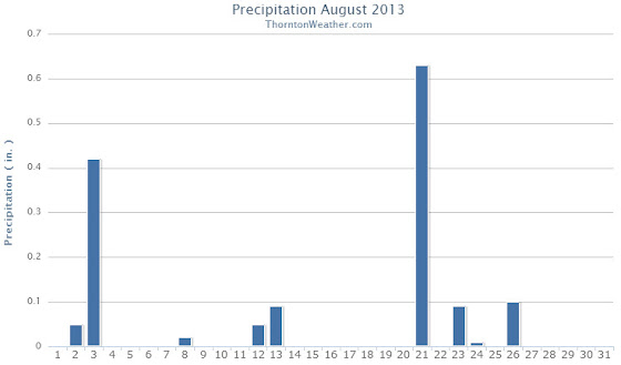
Looking back at last month we certainly do recall the unseasonably warm temperatures that seemed to dominate August 2013. While the high temperatures were indeed high, somehow Thornton managed to end up with a relatively average temperature and precipitation short of normal.
The month started with temperatures into the 90s and much-needed precipitation on two of the first three days. Thunderstorms on the third provided a bit of excitement including strong winds and some hail.
From there the month turned a good bit cooler with seasonal temperatures on many days and even two days (the 7th and 8th) when highs were in the 70s. The latter half of the month however saw a return of the heat with 13 of the final 16 days of the month registering high temperatures at or above 90 degrees.
Looking at the statistics one can easily see how different weather conditions can be across a relatively small area. While Thornton saw a monthly average temperature near normal, Denver was considerably warm. Similarly, our precipitation was below the Denver long term average but out at the airport it was well above average.
In terms of temperatures, the August average temperature in Thornton was 72.0 degrees. This was right near the 1981 to 2010 Denver average for the month of 72.5 degrees. Out at DIA however, the average temperature was a considerably higher 74.6 degrees.
Thornton’s highest temperature of the month was 97.6 degrees on the 20th. Our lowest was 50.2 degrees on the 15th. Officially, Denver’s highest temperature recorded was 99 degrees on the 20th and its lowest 52 degrees on that same day.
Three temperature records were broken in Denver during August 2013.
A new record high of 97 degrees was recorded on August 17 (96 degrees, 1994). On August 20 a record high of 99 degrees was recorded as well (98 degrees, 1987). Also on the 20th, a record high minimum of 70 degrees was set (67 degrees, 2007).
Denver’s long term precipitation for the month of August is 1.69 inches. Thornton fell short of that mark as we registered 1.37 inches in our rain bucket. More than an inch of that was the result of thunderstorms on two days (the 3rd and the 21st).
Denver was able to best us by a large margin recording 2.78 inches of precipitation in August 2013. The bulk of the Mile High City’s precipitation fell on the 22nd when they registered 1.94 inches from a slow moving thunderstorm, one which missed Thornton entirely.
One precipitation record was set in Denver during August 2013. The 1.94 inches of rainfall on the 22nd was a record for the date, easily besting the old record of 0.75 inches set in 1953.
Thornton, Colorado August 2013 Temperatures.Thornton, Colorado August 2013 Precipitation.
...THE DENVER CO CLIMATE SUMMARY FOR THE MONTH OF AUGUST 2013...

CLIMATE NORMAL PERIOD 1981 TO 2010
CLIMATE RECORD PERIOD 1872 TO 2013

WEATHER         OBSERVED          NORMAL  DEPART  LAST YEAR`S
                 VALUE   DATE(S)  VALUE   FROM    VALUE  DATE(S)
                                          NORMAL
................................................................
TEMPERATURE (F)
RECORD
 HIGH             105   08/08/1878
 LOW               40   08/26/1910
                        08/25/1910
                        08/24/1910
HIGHEST            99   08/20       105      -6       98  08/27
                                                          08/03
                                                          08/06
LOWEST             52   08/09        40      12       47  08/17
AVG. MAXIMUM     89.4              87.2     2.2     91.0
AVG. MINIMUM     59.8              57.9     1.9     58.9
MEAN             74.6              72.5     2.1     75.0
DAYS MAX >= 90     16              11.5     4.5       20
DAYS MAX <= 32      0               0.0     0.0        0
DAYS MIN <= 32      0               0.0     0.0        0
DAYS MIN <= 0       0               0.0     0.0        0

PRECIPITATION (INCHES)
RECORD
 MAXIMUM         5.85   1979
 MINIMUM         0.02   1924
TOTALS           2.78              1.69    1.09     0.11
DAILY AVG.       0.09              0.05    0.04     0.00
DAYS >= .01         7               8.6    -1.6        1
DAYS >= .10         2               4.3    -2.3        1
DAYS >= .50         2               1.2     0.8        0
DAYS >= 1.00        1               0.3     0.7        0
GREATEST
 24 HR. TOTAL    1.95   08/21 TO 08/22           08/11 TO 08/11
                                                          08/10 TO 08/11
                                                          08/11 TO 08/11
 STORM TOTAL       MM                                 MM
 (MM/DD(HH))            MM                    08/11(00) TO 08/11(00)
                                                 08/11(00) TO 08/11(00)1
                                                 08/11(00) TO 08/11(00)1

SNOWFALL (INCHES)
RECORDS
 TOTAL             MM   MM
TOTALS            0.0               0.0

DEGREE_DAYS
HEATING TOTAL       0                10     -10        0
 SINCE 7/1          0                16     -16        0
COOLING TOTAL     308               244      64      319
 SINCE 1/1        866               688     178     1122

FREEZE DATES
RECORD
 EARLIEST     09/08/1962
 LATEST       06/08/2007
EARLIEST                        10/07
LATEST                          05/05
..................................................

WIND (MPH)
AVERAGE WIND SPEED              8.8
RESULTANT WIND SPEED/DIRECTION   3/204
HIGHEST WIND SPEED/DIRECTION    43/110    DATE  08/03
HIGHEST GUST SPEED/DIRECTION    55/060    DATE  08/03

SKY COVER
POSSIBLE SUNSHINE (PERCENT)   MM
AVERAGE SKY COVER           0.60
NUMBER OF DAYS FAIR            4
NUMBER OF DAYS PC             23
NUMBER OF DAYS CLOUDY          4

AVERAGE RH (PERCENT)     48

WEATHER CONDITIONS. NUMBER OF DAYS WITH
THUNDERSTORM              0     MIXED PRECIP               0
HEAVY RAIN                2     RAIN                       3
LIGHT RAIN               11     FREEZING RAIN              0
LT FREEZING RAIN          0     HAIL                       0
HEAVY SNOW                0     SNOW                       0
LIGHT SNOW                0     SLEET                      0
FOG                       4     FOG W/VIS <= 1/4 MILE      2
HAZE                     10

-  INDICATES NEGATIVE NUMBERS.
R  INDICATES RECORD WAS SET OR TIED.
MM INDICATES DATA IS MISSING.
T  INDICATES TRACE AMOUNT.
Denver's August 2012 will go into the books as the 5th hottest and 4th driest August since 1872.
There would be no break from the hot and dry summer of 2012 in August as records continued to tumble and the ground remained parched. While a few cold fronts provided some relief, they were short-lived and high pressure dominated during the month.
Denver recorded an average temperature of 75.0 degrees which was 2.5 degrees above normal. This ties August 1994 as the 5th warmest August since record keeping began in 1872.
In all, 20 days recorded high temperatures at or above 90 degrees at Denver International Airport. By the end of the month 2012 moved into the record books as having the most seasonal 90 degree days of any year (66 as of 8/31). Highs ranged from 98 degrees on the 3rd, 6th, 9th, and 27th to a low of 47 degrees on the 17th.
Here in Thornton our average temperature was quite a bit cooler, although still above average in comparison to recent years. Thornton’s average for the month came in at 72.7 degrees.
Thornton recorded 17 days of 90 degree or hotter high temperatures. Our hottest temperature was 96 degrees which occurred on the 27th and 29th. The coldest temperature recorded was 48 degrees on the 17th and 19th.
Precipitation continued to elude the Mile High City as a mere 0.11 inch fell into the rain bucket during the month, and that all came in a single day. This was far below the normal of 1.68 inches for August and put 2012 into the books as the 4th driest August on record.
Thornton fared only slightly better on the precipitation front as we recorded 0.31 inch of rain. As with Denver, that total came all in a single day, the 1st of the month.
...THE DENVER CO CLIMATE SUMMARY FOR THE MONTH OF AUGUST 2012...

CLIMATE NORMAL PERIOD 1981 TO 2010
CLIMATE RECORD PERIOD 1872 TO 2012

WEATHER         OBSERVED          NORMAL  DEPART  LAST YEAR`S
                 VALUE   DATE(S)  VALUE   FROM    VALUE  DATE(S)
                                          NORMAL
................................................................
TEMPERATURE (F)
RECORD
 HIGH             105   08/08/1878
 LOW               40   08/26/1910
                        08/25/1910
                        08/24/1910
HIGHEST            98   08/27        87      11       99  08/25
                        08/03
                        08/06
                        08/09
LOWEST             47   08/17        40       7       55  08/20
AVG. MAXIMUM     91.0              87.2     3.8     92.7
AVG. MINIMUM     58.9              57.9     1.0     61.3
MEAN             75.0              72.5     2.5     77.0
DAYS MAX >= 90     20              11.5     8.5       22
DAYS MAX = .01         1               8.6    -7.6        3
DAYS >= .10         1               4.3    -3.3        1
DAYS >= .50         0               1.2    -1.2        0
DAYS >= 1.00        0               0.3    -0.3        0
GREATEST
 24 HR. TOTAL    0.11   08/11 TO 08/11           08/03 TO 08/03

SNOWFALL (INCHES)
RECORDS
 TOTAL            0.0  NO SNOW EVER RECORDED IN AUGUST
TOTALS            0.0  NO SNOW EVER RECORDED IN AUGUST

DEGREE_DAYS
HEATING TOTAL       0                10     -10        0
 SINCE 7/1          0                16     -16        0
COOLING TOTAL     319               244      75      382
 SINCE 1/1       1122               688     434      863

FREEZE DATES
RECORD
 EARLIEST     09/08/1962
 LATEST       06/08/2007
EARLIEST                        10/07
LATEST                          05/05
..................................................

WIND (MPH)
AVERAGE WIND SPEED              9.9
RESULTANT WIND SPEED/DIRECTION   3/217
HIGHEST WIND SPEED/DIRECTION    38/330    DATE  08/30
HIGHEST GUST SPEED/DIRECTION    45/330    DATE  08/30

SKY COVER
POSSIBLE SUNSHINE (PERCENT)   MM
AVERAGE SKY COVER           0.50
NUMBER OF DAYS FAIR            8
NUMBER OF DAYS PC             22
NUMBER OF DAYS CLOUDY          1

AVERAGE RH (PERCENT)     34

WEATHER CONDITIONS. NUMBER OF DAYS WITH
THUNDERSTORM              4     MIXED PRECIP               0
HEAVY RAIN                0     RAIN                       0
LIGHT RAIN                9     FREEZING RAIN              0
LT FREEZING RAIN          0     HAIL                       0
HEAVY SNOW                0     SNOW                       0
LIGHT SNOW                0     SLEET                      0
FOG                       0     FOG W/VIS
August 26 to September 1 - This Week in Denver Weather History
Significant events on Denver’s weather history calendar get a bit less numerous as we enter what is historically a relatively quiet period of the year. That isn’t to say however that major weather events can’t occur. Our look back at this week in Denver weather history includes a massive hail storm in 1944, many events in which lightning injured people and the warmest temperature ever recorded in September.
From the National Weather Service:
19-30
In 1875…grasshoppers appeared in great numbers at 10:00 am on the 19th. Thousands landed on the ground. The streets were literally covered with them. Swarms of grasshoppers were seen on each day. All gardens in the city were devastated…and in the countryside the grasshoppers were very destructive to ripened grain. On the 30th the grasshoppers were so numerous as to almost darken the sun.
24-26
In 1910…the lowest temperature ever recorded in August…40 degrees…occurred on each of these days and on August 22… 1904. The unusually cold weather for so early in the season brought sub-freezing minimum temperatures to much of the Colorado northeastern plains.
26
In 1944…one of the most destructive hailstorms in the city in a decade caused damage estimated at nearly one million dollars. The storm occurred within a period of 10 to 30 minutes…between 2:00 pm and 3:00 pm. The hail varied in size from very small to as large as 1 1/2 inches in diameter. Hail covered the ground to a depth of 5 to 6 inches in some sections of the city. Several people were cut by broken glass. The hail and heavy rain flooded underpasses to a depth of 6 feet…and the occupants of stalled autos had to be rescued. Sewers were unable to handle the sudden amount of water and water backed up and flooded a number of basements. A few first floors of buildings were flooded. The water department had a busy time replacing manhole covers that had been displaced by the water pressure. Trees were stripped…one was severely broken…and telephone lines were downed. Roofs…windows… automobiles…awnings…and gardens were severely damaged. Flowers and gardens in some sections of the city were a total loss. Greenhouses were extensively broken with an estimated 20 carloads of glass shattered. Vegetable and truck crops in and around the city were severely shredded. The next day the American Red Cross was designated by the war agency to grant any and all priorities needed to obtain materials and supplies to replace and repair the damage. In downtown Denver…the thunderstorm produced 0.95 inch of rain and heavy hail along with sustained northwest winds to 25 mph.
In 1961…strong winds blew in the walls of a warehouse under construction in Denver. Two workmen suffered a fractured foot and body bruises.
26-27
In 1980…two heavy thunderstorms hit Arvada and Westminster… Dumping up to 1.50 inches of rain in less than an hour. At least two streets were washed out and a number of homes and cars were damaged when a creek flooded. Three homes in Arvada sustained minor lightning damage.
27
In 1910…a thunderstorm produced south winds sustained to 40 mph.
In 1961…strong thunderstorm winds and heavy rain occurred at 79th and federal blvd. In Westminster. The strong winds blew the roofs off lumber sheds onto parked cars.
In 1967…a young woman was killed by lightning while horseback riding in the suburbs just west of Denver. Her horse died several hours after the incident. A young man and another young woman were also knocked from their horses by the impact of the lightning and required hospitalization.
In 1991…heavy thunderstorm rainfall totaled 0.91 inch at Stapleton International Airport…where 1/4 inch diameter hail was measured.
In 1996…localized street flooding occurred in the Fort Lupton area when 2 to 3 inches of rain fell in 45 minutes. The roof of a community college began leaking…which caused damage to ceiling tiles. The roof was under repair from hail damage which had occurred earlier in the summer. A weak tornado (f0) was sighted near Fort Lupton. No damage was reported.
In 1999…a slow moving thunderstorm dumped 5 inches of rain in 2 hours near Dacono. A severe thunderstorm produced 3/4 inch diameter hail in Castle Rock.
In 2002…severe thunderstorms spread large hail over metro Denver. Hail as large as 2 inches in diameter fell in Jefferson County 5 to 11 miles northwest of Golden. Other large hail reports included: 1 1/2 inches near Golden and in Lakewood; 1 1/4 inches in Nederland; 1 inch hail near Elizabeth…Louviers…Rollinsville…and Blackhawk; 7/8 inch hail near Acequia in Douglas County. A thunderstorm produced a trace of rain and a microburst wind gust to 52 mph at Denver International Airport.
In 2003…lightning struck a house and sparked a fire in Arvada. Damage to the roof and ceiling was extensive.
In 2005…lightning struck an unoccupied home in Parker. The resulting fire damaged the roof…attic…and second floor bedroom. Damage was estimated at 15 thousand dollars.
August 19 to August 25 - This Week in Denver Weather History
Funnel clouds, tornadoes, deadly flooding and more highlight our look back at this week in Denver weather history.
From the National Weather Service:
16-19
In 1979…heavy thunderstorm rains on each of 4 consecutive days dumped a total of 2.62 inches of rain on Stapleton International Airport. The heaviest rain…1.05 inches… On the 19th was accompanied by 1/4 inch diameter hail.
18-19
In 1875…nearly 0.75 inch of rainfall in the city overnight… Possibly assisted by heavier rainfall upstream…produced a decided and rapid rise in Cherry Creek…which washed out some bridges. Other small creeks and streams were filled to overflowing.
19
In 1983…heavy rain fell across the northern metro Denver suburbs with 1.50 to 1.80 inches of rain in Broomfield… Arvada…and Thornton.
In 1989…lightning killed a 31-year-old man and injured his 10 year old nephew when it hit a tree they were walking under in the foothills about 5 miles west of Boulder. The boy received mouth to mouth resuscitation on the scene and recovered after being hospitalized overnight. Three other people were knocked to the ground by the bolt…but were uninjured.
In 1990…3/4 inch diameter hail was reported in Wheat Ridge. A thunderstorm over west Denver dumped an inch of rain in 20 minutes…causing minor street flooding. One inch diameter hail was reported over east Denver. Ping pong to golf ball size hail was reported 14 miles northeast of Denver at the intersection of 122nd Ave. and Brighton Blvd. The hail stones knocked out windows and did an unspecified amount of damage to the roof of a house. Close by…heavy thunderstorm rains caused gullies…irrigation ditches…and small streams to overflow their banks near the intersection of 120th Avenue and Riverdale Road. Flood waters 1 to 2 feet deep covered the river bottom land along the South Platte River. However…no structures were threatened by the flood waters.
In 1999…heavy rain…up to 5 inches in two hours…caused east tollgate creek to jump its banks. The bike path adjacent to the creek was underwater at several locations. Several underpasses were also flooded…halting traffic. In addition…an unfinished playground at a local elementary school was completely flooded. Lightning struck a vehicle at east Evans Avenue and Tower Road. The woman inside the vehicle was not injured.
19-30
In 1875…grasshoppers appeared in great numbers at 10:00 am on the 19th. Thousands landed on the ground. The streets were literally covered with them. Swarms of grasshoppers were seen on each day. All gardens in the city were devastated…and in the countryside the grasshoppers were very destructive to ripened grain. On the 30th the grasshoppers were so numerous as to almost darken the sun.
August 12 to August 18 - This Week in Denver Weather History
Denver’s weather calms considerably in August as compared to many other months but the history books show plenty of notable events in our past. Lightning, flooding rain and even a tornado highlight this week in Denver weather history.
8-13
In 1875…clouds of grasshoppers were seen flying through the air on the prevailing winds during each day.
12
In 1876…the temperature climbed to a high of 100 degrees in downtown Denver.
In 1941…excessive thunderstorm rainfall flooded streets and delayed traffic for a few hours in some sections of the city. The basements of a considerable number of homes and commercial buildings were flooded. The total value of the damage was unknown. Only 0.94 inch of thunderstorm rainfall was recorded downtown.
In 1969…a man and a 9-year old boy were injured…when lightning struck a tree near where they were standing. Both were revived after treatment…but the boy later died of respiratory failure due to electrical shock.
In 1984…heavy thunderstorm rains drenched southern metro Denver. Rural roads in Douglas County received minor washouts. Hail…as large as 3/4 inch in diameter…was reported in southeast Aurora with one inch diameter hail reported near Parker. Rainfall totaled 1.00 inch at Stapleton International Airport.
12-13 in 1975…heavy rains caused flash flooding along the foothills from Denver north. Thunderstorm rainfall totaled 1.56 inches at Stapleton International Airport.
In 2004…a brief cool spell resulted in two daily temperature records. The low temperature of 49 degrees was a record minimum for the 12th…as was the low temperature of 48 degrees on the 13th.
13
In 1959…thunderstorm winds gusted to 53 mph at Stapleton Airport.
In 1983…thunderstorms dumped torrential rain in Northglenn… Thornton…and Broomfield. Northglenn was drenched with 1.72 inches in 30 minutes. Street flooding was widespread. Hail…as large as 3/4 inch in diameter…was reported 7 miles northeast of Boulder along with heavy rain which caused some street flooding.
In 2000…lightning sparked 3 small grass fires near Golden. The fires were quickly contained. Hail as large as 3/4 inch in diameter fell in Castle Rock.
August 5 to August 11 - This Week in Denver Weather History
As we enter August the weather typical is a bit calmer as the atmosphere settles down. However our look back at this week in Denver weather history shows that Mother Nature can still visit plenty of excitement on us.
From the National Weather Service:
5
In 1881…the low temperature cooled to only 76 degrees…the record high minimum temperature for the month.
In 1889…southwest winds were sustained to 42 mph.
In 1918…hail pelted the city…but was light and caused no damage. Precipitation totaled 0.25 inch. Northwest winds were sustained to 31 mph.
In 1964…lightning struck two boys in Denver while playing ball. One was treated and released from the hospital…but the other boy suffered second degree electrical shock and cardiac arrest and was hospitalized in critical condition for several days.
In 1969…two tornadoes touched down briefly in an open field southeast of Buckley Field in Aurora. No damage was reported.
In 1970…heavy rain in the Indian Hills area in the foothills west of Denver caused flash flooding…which washed out roads and damaged other property. Hail accumulated to a 3 inch depth with stones up to golf ball size; however…most of the damage was from flooding.
In 1982…2.38 inches of rain fell in an hour in Arvada… Causing minor flooding on Ralston Creek. In Westminster… 1 1/2 inches of rain fell…causing damage to streets and culverts. In addition…lightning caused some minor power outages across metro Denver.
In 1983…very heavy thunderstorms hit the southern portion of metro Denver. Heavy rainfall…as much as 2.89 inches in 38 minutes…caused widespread street flooding in southeast Denver. Two feet of water covered a section of I-25. Hail up to golf ball size accompanied the storm in Littleton and Englewood…along with 60 mph winds.
In 1984…a heavy thunderstorm drenched Littleton with up to 2.35 inches of rain in an hour…along with small hail that piled up to 2 inches deep. Flood waters were up to 4 feet deep in parts of town with many basements flooded. There were some power outages caused by lightning.
In 1990…a thunderstorm dumped 1.25 inches of rain in 12 minutes near tower and smoky hill roads in southeast Aurora. Minor street flooding was reported in the area.
In 1992…a pilot reported two funnel clouds near Cheery Creek Reservoir. Both dissipated quickly. Dime size hail fell near Franktown.
In 1994…one inch diameter hail fell near Strasburg. No damage was reported.
In 1999…a dog kennel east of Denver International Airport… Was flooded when a small dam…upstream in Elbert County… Was breached. The floodwaters…up to 4 feet deep…washed away some 6-foot fences and other small buildings. Ten of the 70 dogs boarded at the kennel drowned.
In 2002…a mail carrier was struck by lightning as he inserted a key into a multi-unit mailbox in Bailey. The shock knocked the man back against the mail truck. He suffered minor injuries. Lightning struck a residence in Commerce City. The resulting fire destroyed the roof of a detached garage and damaged much of its contents. Hail as large as 1 3/4 inches in diameter pelted pine. One inch diameter hail fell in Arvada and southwest Denver. Heavy rain triggered a mudslide along U.S. Highway 285 near Bailey. Both lanes of traffic had to be closed until debris could be removed from the highway. Several residences in the Bailey and Glenisle areas were also flooded.
In 2004…heavy thunderstorm rainfall caused localized flash flooding in Virginia canyon near Idaho Springs. Sections of the Virginia Canyon Road had to be closed due to the floodwaters.
In 2008…a severe thunderstorm produced large hail…up to 1 1/4 inches in diameter…northeast of Parker. Several automobiles were damaged.
July 29 to August 4 - This Week in Denver Weather History
The effects of our annual monsoon season are portrayed in detail in our look back at this week in Denver weather history. Numerous cases of flooding resulting from heavy rainfall are seen as are other severe weather events including hail and even tornadoes.
From the National Weather Service:
13-5
In 2008…a streak of 24 consecutive days of 90 degrees shattered the previous record of 18 consecutive days established in 1901 and 1874. Ironically…no new single day record high temperatures were set in the month of July. In August however…a record of 104 degrees was set on the 1st…and another record of 103 degrees was set on the 2nd. In addition…a record low min of 70 degrees was set on August 2nd.
18-2
In 1987…a streak of 16 consecutive days of 90 degrees ranked 4th on the list of hot streaks. The record of 24 consecutive days was established in the summer of 2008.
27-31 in 1956…96 percent of the total precipitation for the month of July occurred over the last five days of the month. Heavy thunderstorms produced 4.00 inches of rainfall at Stapleton Airport. This amount of precipitation in 5 days or less had been exceeded only 3 times in previous record. The last time had been in December of 1913 as snow. Considerable property damage occurred across metro Denver from flooding.
28-30
In 1889…dense smoke from forest fires in the mountains obscured the sun over the city for three days.
In 1971…a vigorous cold front late on the 28th produced northeast wind gusts to 39 mph and record breaking cold temperatures on the 29th and 30th. The temperature dipped to 47 degrees on the 29th and 43 degrees on the 30th… Setting record minimums for the dates. Upslope cloudiness along with rain and fog early on the 29th helped set a record low maximum temperature of 58 degrees for the date.
29
In 1878…a total eclipse of the sun was observed at 2:20 pm. From before to during the eclipse…the temperature in the sun fell from 114 degrees to 82 degrees…while the shade temperature fell from 89 degrees to 83 degrees.
In 1880…heavy thunderstorm rain and hail flooded streets and ditches.
In 25 minutes…0.76 inch of rain fell on the city along with large hail to 3/4 inch in diameter. There were no strong winds with the storm.
In 1890…a thunderstorm produced sustained west winds to 48 mph with gusts to 60 mph…but only 0.01 inch of rain.
In 1956…heavy rain and hail fell over west and north Denver.
In 1964…hail to 3/4 inch in diameter fell at Lowry Airfield.
In 1978…a small tornado was sighted just east of Parker. No damage was reported.
In 1989…heavy rain drenched all areas of the Front Range… Both in the foothills and adjacent plains. Amounts of 1 to 3 inches were general over the area. Damage was confined to a few minor road washouts and some street…basement…and crop flooding. Thunderstorm rainfall totaled 1.44 inches at Stapleton International Airport where north winds gusted to 43 mph. Lightning struck a 250 thousand dollar home near Nederland and started a fire which destroyed all of it except two garages. Lightning started a fire in a home in Evergreen. It reached the house by hitting a tree…then traveling through a metal clothesline strung between the tree and the building.
In 1995…thunderstorm winds gusted to 59 mph in Brighton. Thunderstorm winds from the south-southeast gusted to 41 mph at Denver International Airport. High temperature of 99 degrees was a new record maximum for the date in Denver.
In 1997…heavy rain caused flooding in an apartment building in Westminster. Several residents had to be evacuated from their apartments. A woman in aspen park received minor injuries…when lightning passed through an office window and struck her. She suffered temporary blindness for about 15 minutes.
In 2003…hail as large as 1 inch in diameter pelted Conifer… Highlands Ranch…and Franktown.
August 2011 brought record-setting heat to Denver.
You didn’t need to know the statistics to be well aware that August was unusually warm and dry in Thornton and Denver. The month saw little precipitation and record setting temperatures became commonplace, particularly in the latter half of the month.
For moisture, Denver recorded a mere 0.30 inch in the rain bucket at Denver International Airport. This was 1.27 inches below the normal of 1.57 inches. The month barely missed making the list of top 10 driest Augusts by only 0.02 inch.
Afternoon thunderstorms were seen 12 times at DIA but only one brought measurable precipitation. The storms were typically high-based and yielded little more than wind.
Thornton followed DIA’s lead with little precipitation as we only saw 0.27 inch during the month.
Temperatures were the real weather story for August 2011 as rather than seeing cooler temperatures through the month like normal, the mercury stayed exceedingly high.
Overall DIA saw an average temperature of 77.0 degrees making it the hottest August on record. This surpassed the previous record August from 1937 when 76.8 degrees was seen. The month also went into the record books as the sixth warmest month ever recorded in Denver.
Temperatures ranged from a high of 99 degrees on the 25th down to a low of 55 degrees on the 20th. Through August 31st, Denver had seen 71 consecutive days of 80 degrees or warmer weather. This easily bested the previous longest streak of 59 days set in 2002.
Seven individual temperature records were set during the month. These included a tied record high on the 18th of 98 degrees last set in 1986; the 23rd tied the record high of 98; the 24th set a new record high for the date of 98 degrees; the 25th set a new record high of 99 degrees; the 28th set a record high of 96 degrees; the 28th saw a record high minimum of 67 degrees; the 31st tied the record high of 98 degrees.
Here in Thornton we were certainly hot but not nearly as much so as DIA. We recorded an average temperature of 74 degrees. Our warmest reading was 96.2 degrees and our coolest was 54. In all we saw 20 days with temperatures of 90 degrees or warmer.
While the high temperatures were notable, DIA benefits from later arrival of the typical afternoon thunderstorms due to its location further east of the rest of Denver. This certainly aided in the airport recording higher temperatures than anywhere else in the metro area. For more on that story, check out the Denver Weather Examiner.
CLIMATE REPORT...CORRECTED
NATIONAL WEATHER SERVICE BOULDER, CO
430 PM MDT FRI SEP 2 2011

...................................

...THE DENVER CO CLIMATE SUMMARY FOR THE MONTH OF AUGUST 2011...

CLIMATE NORMAL PERIOD 1981 TO 2010
CLIMATE RECORD PERIOD 1872 TO 2011

WEATHER         OBSERVED          NORMAL  DEPART  LAST YEAR'S
                 VALUE   DATE(S)  VALUE   FROM    VALUE  DATE(S)
                                          NORMAL
................................................................
TEMPERATURE (F)
RECORD
 HIGH             105   08/08/1878
 LOW               40   08/26/1910
                        08/25/1910
                        08/24/1910
HIGHEST            99   08/25       105      -6       97  08/22
LOWEST             55   08/20        40      15       47  08/17
AVG. MAXIMUM     92.7              87.2     5.5     88.6
AVG. MINIMUM     61.3              57.9     3.4     59.0
MEAN             77.0              72.5     4.5     73.8
DAYS MAX >= 90     22              11.5    10.5       12
DAYS MAX <= 32      0               0.0     0.0        0
DAYS MIN <= 32      0               0.0     0.0        0
DAYS MIN <= 0       0               0.0     0.0        0
PRECIPITATION (INCHES)
RECORD
 MAXIMUM         5.85   1979
 MINIMUM         0.02   1924
TOTALS           0.30              1.57   -1.27     1.05
DAILY AVG.       0.01              0.05   -0.04     0.03
DAYS >= .01         3               8.6    -5.6        6
DAYS >= .10         1               4.3    -3.3        3
DAYS >= .50         0               1.2    -1.2        1
DAYS >= 1.00        0               0.3    -0.3        0
GREATEST
 24 HR. TOTAL    0.27   08/03 TO 08/03   0.68  08/01/10 TO 08/01/10
SNOWFALL (INCHES)
RECORDS
 TOTAL            0.0   NO SNOW EVER RECORDED IN AUGUST
TOTALS            0.0   NO SNOW EVER RECORDED IN AUGUST

DEGREE_DAYS
HEATING TOTAL       0                 5      -5        0
 SINCE 7/1          0                11     -11        3
COOLING TOTAL     382               244     138      280
 SINCE 1/1        863               688     175      762

FREEZE DATES
RECORD
 EARLIEST     09/08/1962
 LATEST       06/08/2007
EARLIEST                        10/07
LATEST                          05/05
..................................................

WIND (MPH)
AVERAGE WIND SPEED              8.8
RESULTANT WIND SPEED/DIRECTION   3/202
HIGHEST WIND SPEED/DIRECTION    39/180  DATE  08/31  38/190 08/12
HIGHEST GUST SPEED/DIRECTION    48/200  DATE  08/31  45/340 08/12
                                                            08/16
SKY COVER
POSSIBLE SUNSHINE (PERCENT)   MM (NO LONGER RECORDED)
AVERAGE SKY COVER           0.50
NUMBER OF DAYS FAIR            4
NUMBER OF DAYS PC             26
NUMBER OF DAYS CLOUDY          1

AVERAGE RH (PERCENT)     41

WEATHER CONDITIONS. NUMBER OF DAYS WITH
THUNDERSTORM              0     MIXED PRECIP               0
HEAVY RAIN                1     RAIN                       1
LIGHT RAIN                8     FREEZING RAIN              0
LT FREEZING RAIN          0     HAIL                       0
HEAVY SNOW                0     SNOW                       0
LIGHT SNOW                0     SLEET                      0
FOG                       4     FOG W/VIS <= 1/4 MILE      1
HAZE                      5

-  INDICATES NEGATIVE NUMBERS.
R  INDICATES RECORD WAS SET OR TIED.
MM INDICATES DATA IS MISSING.
T  INDICATES TRACE AMOUNT.
Weather, natural disasters & climate news and information.