Last year a pre-holiday snowstorm covered Thornton in a blanket of white ensuring we had a white Christmas. This year the color will be brown for the Front Range but a sizeable chunk of the United States will have snow on the ground for the holiday.
From North Dakota to Minnesota and Iowa, a major winter storm dumped nearly two feet of snow on the upper Midwest two weeks ago. The sheer weight of the snow was enough to collapse the Metrodome in Minnesota and send the Minnesota Vikings scrambling to find someplace to play football.
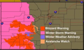
A new storm in recent days has brought flooding rains to California, Nevada, Arizona and Utah while the higher elevations in those states plus western Colorado see extraordinary snowfall. Over a five day period many areas were finding that even a yard stick isn’t tall enough to record the snow that has fallen.
Thursday brings a slight chance for some precipitation but there will little if any accumulation from it. Those in Denver wanting a white Colorado Christmas will need to head for the hills. Some of the extraordinary snowfall totals recorded over the last few days include:
GOTHIC                               82.0
CRESTED BUTTE 6.2 N                  77.5
COAL BANK PASS                       48.0
RED MOUNTAIN PASS                    44.5
MOLAS PASS                           41.0
SILVERTHRONE 10 E                    32.0
DILLON 9 E                           29.0
BRECKENRIDGE 2 W                     28.0
WALDEN 16.3 WSW                      23.5
COPPER MOUNTAIN                      23.0
STEAMBOAT SPRINGS 1 SE               20.2
WOLF CREEK PASS 1 E                  18.0
VAIL 2.6 E                           14.4
For more on the nation’s snow situation, check out the story on the Natural Disasters Examiner.


 Here in Colorado, much of the western slope is under