Tag Archives: December Weather

December 2023 weather recap: Mild, dry weather continues

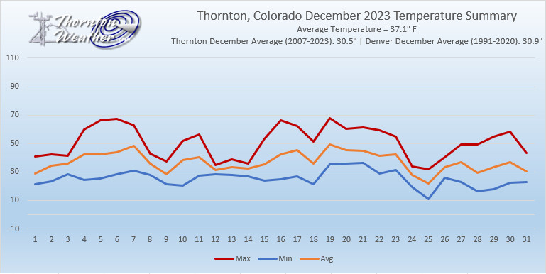
Thornton, Colorado December 2023 Temperature Summary (ThorntonWeather.com)

Thornton wrapped up 2023 with similar weather conditions as had been seen the previous two months. Temperatures were well above normal and precipitation was scarce.

The month was a quiet one, lacking any sort of real weather drama. We started out on the cool side but then put together a string of well above normal days from the 4th to the 7th. We then turned colder and saw our first and biggest snow of the month, 1.7 inches, on the 9th. The balance of the month saw some ups and downs, mainly ups, with only three more snowfalls, all very light.

Thornton ended the month with an average temperature of 37.1 degrees. This was far above the running 17-year average for the month of 30.5 degrees. It also put December 2023 into the books as the warmest December of those 17 years, besting the previous warmest of 37.0 degrees in 2021.

The warmest temperature of 68 degrees was seen on the 19th while the coldest temperature of 11.2 degrees came on Christmas morning.

As measured at Denver International Airport, the Mile High City was similarly warm. Denver’s December 2023 average temperature was 37.4 degrees, besting Thornton’s number. That too was well above their long-term average for the month of 31.2 degrees and goes into the Denver weather history books tying December 1929 as the 17th warmest December on record.

Along with the warmth, we saw little precipitation. Thornton recorded a mere 0.26 inches in the bucket. That was only about half of the 17-year running average for December of 0.45 inches. Much of that can be attributed to the relative lack of snowfall as we only saw 3.1 inches of the white stuff. That is less than half of the 8.4 inches Thornton has averaged during December over the past 17 years and the third least snowy December over that period.

Out at the airport, it was quite dry as well. Denver recorded only 0.12 inches in their bucket, far below the long-term average of 0.35 inches. The Mile High City was also lighter on snow than us, seeing only 1.4 inches. That puts December 2023 into the books as the 18th least snowy December on record.

Click here to view Thornton’s complete December 2023 climate summary report.

Thornton, Colorado December 2023 Precipitation Summary (ThorntonWeather.com)

December 31 to January 6: This week in Denver weather history

This Week in Denver Weather History

One of our coldest and driest months, January is not normally known for its weather extremes. However just like any in Colorado, significant events can occur as we see in our look back at this week in Denver weather history.

From the National Weather Service:

25-31

In 1980…temperatures were unusually warm during the week between Christmas and New Year’s. High temperatures for the week ranged from the mid-50’s to the mid-70’s. Four temperature records were set. Record highs occurred on the 26th with 68 degrees…the 27th with 75 degrees…and the 30th with 71 degrees. A record high minimum temperature of 41 degrees occurred on the 27th.

30-31

In 1886…heavy snow totaled 6.5 inches in downtown Denver. Most of the snow…4.5 inches…fell on the 31st. North winds were sustained to 18 mph.

In 1928…snowfall of 0.6 inch was the only measurable snow of the month in the city.

In 1947…post-frontal heavy snow totaled 6.3 inches over downtown Denver. Most of the snow fell on the 30th. North winds were sustained to 17 mph on the 30th.

In 1995…the foothills west of Denver received 5 to 9 inches of new snow…except for Bailey where 11 inches of snow were measured. No snow fell at the site of the former Stapleton International Airport.

In 2021…the first significant snowfall of the season finally made its mark…impacting the mountains…foothills…and nearby plains with much needed moisture. In the mountains and foothills…storm totals ranged from 6 to 15 inches. Elsewhere 5 to 10 inches of snow fell west of I-25…with 3 to 7 inches east of the interstate. At Denver International Airport…4.5 inches of snow was observed.

31

In 1890…northeast winds were sustained to 46 mph with gusts as high as 60 mph behind an apparent cold front. A trace of sleet fell.

In 1899…northwest winds were sustained to 44 mph with gusts as high as 48 mph. The Chinook winds warmed the temperature to a high of 49 degrees.

In 1927…the temperature was below zero all day. The high temperature of 3 degrees below zero was a record low maximum for the date. The low temperature was 11 degrees below zero.

In 1970…warm Chinook winds whistled through Boulder. A wind gust to 92 mph was recorded at the National Center for Atmospheric Research…while at the National Bureau of Standards…winds peaked to 70 mph. Northwest winds gusting to 30 mph warmed the temperature to a high of 60 degrees at Stapleton International Airport.

In 1993…occasional high winds occurred northwest of Denver and in the foothills. A wind gust to 85 mph was recorded at Jefferson County Airport in Broomfield. Wind gusts to 86 mph occurred on Squaw Mountain with 75 mph recorded at Rollinsville. West winds gusted to 46 mph at Stapleton International Airport.

In 2011…an intense and fast moving storm system… produced a powerful windstorm across the Front Range. In the mountains and foothills…several locations recorded wind gusts in excess of 100 mph. Numerous trees were knocked down throughout Arapahoe National Forest. One man was killed when he was impaled by a falling tree limb while driving along U.S. Highway 36…north of Boulder. The strong winds produced extensive damage to fences and roofs… and also knocked down trees which resulted in power outages that affected 19 thousand residents along the Front Range.  In the mountains and foothills…peak wind gusts included: 111 mph…3 miles south-southeast of Pinecliffe; 101 mph…1 mile west of Lyons; 94 mph atop Berthoud Pass; 86 mph…3 miles south of Golden; 84 mph… 4 miles northwest of Boulder; 81 mph in Boulder; 79 mph at Kenosha Pass…NCAR Mesa Lab and the junction of U.S. Highways 72 and 93; 77 mph at the National Wind Technology Center; and 76 mph…3 miles north-northwest of Morrison. Peak wind gusts for the Urban Corridor included: 80 mph…3 mile east of Cedar Point; 77 mph in north Longmont; 67 mph…10 miles east of Parker; 64 mph at Buckley AFB and Lakewood; 60 mph at Bennett and Front Range Airport in Watkins; 59 mph at Denver International Airport and Deer Trail; 58 mph at Rocky Mountain Regional Airport in Broomfield and 2 miles north-northwest of Louisville.

In 2021…much of the Front Range Foothills…Urban Corridor and adjacent plains were classified to be in severe to extreme drought (D2/D3) through the month of December. These conditions contributed significantly to the Marshall Wildfire…the costliest fire in Colorado history. The Front Range experienced a very wet first half of the year…with well above normal precipitation and lush…tall grass growth. However…starting around July…a persistently dry weather pattern set up and held firm through the entire fall and early winter. Vegetation…while typically dry this time of year…was exceptionally dry as very little precipitation had fallen through the entire fall season. The ongoing drought conditions ensured larger fuels such as shrubs and trees were likewise critically dry. From the period of July 1st through December 29th…temperature and precipitation climate records showed Denver was the 2nd warmest…and by far the driest in recorded history…since 1872. Boulder was ranked as 2nd warmest for precipitation…while 13th driest in recorded history.

31-1

In 1900…low temperatures dipped to 19 degrees below zero on both days to establish daily record minimum temperatures.

In 1975…only 4.2 inches of snow fell at Stapleton International Airport…while north of Denver a major blizzard raged. All roads north of Denver into Wyoming were closed when strong winds whipped snow into 5 to 6 foot drifts. North winds gusted to 43 mph at Stapleton International Airport on the 31st…causing some blowing snow. Freezing drizzle also fell on the 31st.

In 1984…heavy snow fell in the foothills with 8 inches at Boulder and 6 inches in southern and western metro Denver. Only 1.5 inches of snow fell overnight at Stapleton International Airport.

In 1991…a New Year’s Eve snow storm dumped 2 to 8 inches of snow across northeastern Colorado. Snowfall totaled 3.4 inches at Stapleton International Airport. The 1.9 inches of snow that fell on the 31st was the only measurable snowfall of the month.

In 2008…another brief period of high winds occurred in and near the foothills of Boulder and Jefferson counties. In Nederland…the strong wind snapped a blue spruce which landed on a nearby propane tank. Some roofs in the immediate area were damaged and power lines were downed; which left 126 residences without electricity for six hours. Peak wind gusts included 90 mph at the national wind technology center…and 89 mph; 6 miles northwest of Boulder. At Denver International Airport…a peak wind gust of 23 mph was measured from the southwest.

31-6

In 1973…the 31st marked the start of a protracted cold spell that extended into January of 1974 when temperatures dipped below zero on 7 consecutive days. Record daily minimum readings occurred on the 3rd and 5th when the temperature plunged to 17 degrees below zero on both days. A record low daily maximum temperature of only 4 degrees occurred on the 5th.

31-7

In 1941…a protracted cold spell through January 7…1942… Produced below zero low temperatures on 7 of the 8 days. A low temperature of 2 degrees on the 3rd prevented a string of 8 days below zero. The coldest days during the period were the 1st with a high of 2 degrees and a low of 9 degrees below zero…the 4th with a high of 2 degrees and a low of 11 degrees below zero…and the 5th with a high of 26 degrees and a low of 12 degrees below zero.

1

In 1875…the temperature fell 27 degrees between 3:00 pm and 5:00 pm. The high for the day was 43 degrees…and the low was 8 degrees. Occasional snow flurries fell during the day…but not enough to cover the ground.

In 1885…dense smoke choked the skies over downtown Denver until midday.

In 1910…a rare trace of light rain fell during the morning.

In 1911…post-frontal northeast winds were sustained to 40 mph. Only a trace of snow fell in downtown Denver.

In 1952…snowfall of 0.03 inch was the only measurable snowfall of the month and resulted in 0.01 inch of melted snow…the only precipitation of the month.

In 1956…west-northwest winds gusted to 52 mph at Stapleton Airport.

In 1996…the first snow storm of the new year dumped more than a foot of snow in the Front Range foothills with 4 to 9 inches across the western and southern sections of metro Denver. Snow totals included: 14 inches at conifer; 11 inches at Evergreen; and 10 inches at Eldora Ski Resort… West of Boulder. Snowfall totaled only 1.2 inches at the site of the former Stapleton International Airport. North- northeast winds gusted to 30 mph at Denver International Airport.

In 2003…only a trace of snow fell at the site of the former Stapleton International Airport. This…along with a trace of snow on the 22nd…was the only snow of the month…which equaled the 1934 record for the least snowiest January.

1-2

In 1896…warm Chinook winds on the 1st became cold bora winds on the 2nd. Southwest winds sustained to 60 mph with gusts as high as 66 mph warmed the temperature to a high of 55 degrees on the 1st. Northwest winds sustained to 54 mph with gusts to 60 mph resulted in snowfall of 0.3 inch and a high temperature of only 31 degrees on the 2nd.

1-5

In 1940…the first days of the month were characterized by a mixture of drizzle…light snow…and fog. Fog occurred on each day. On the 4th and 5th considerable glazing resulted from freezing drizzle. All objects were coated with a glaze on the windward side. This resulted in very slippery streets…which caused several minor traffic accidents. The glaze was not heavy enough to damage wires and cables. Continue reading December 31 to January 6: This week in Denver weather history

December 2023 top shots: Monthly photo slideshow

Cool clouds at sunrise over Denver. (Bill Hutchinson)

The month of December can offer everything from bone dry conditions to bone chilling cold and monstrous snowstorms.  The weather and wildlife all afford an abundance of photo opportunities as our December photo slideshow shows.

Leaves have fallen from trees now and the landscape can sometimes look quite stark.  However it only takes a quick shot of snow to change that picture greatly.  Throw in gorgeous sunrises and sunsets, plenty of wildlife big and small, kids playing and much more and the month can be quite colorful and eventful.

  • Slideshow updated December 26, 2023
  • To learn more about how to send your photo to us for inclusion in the slideshow, see below the slideshow.

Showcasing images captured by ThorntonWeather.com readers as well as some of our own, our monthly slideshow covers the entire gamut of weather-related imagery.

Sunsets, sunrises, wildlife and of course every type of weather condition are vividly depicted in images captured from yours and our cameras.

What is missing in the slideshow above?  Your photo!

Our monthly photo slideshow is going to feature images that we have taken but more importantly images that you have captured.  The photos can be of anything even remotely weather-related.

Landscapes, current conditions, wildlife, pets, kids.  Whimsical, newsy, artsy.  Taken at the zoo, some other area attraction, a local park, a national park or your backyard.  You name it, we want to see and share it!

Images can be taken in Thornton, Denver or anywhere across the extraordinary Centennial State.  We’ll even take some from out of state if we can tie it to Colorado somehow.

We’ll keep the criteria very open to interpretation with just about any image eligible to be shown in our slideshows.

What do you win for having your image in our slideshow?  We are just a ‘mom and pop’ outfit and make no money from our site so we really don’t have the means to provide prizes.  However you will have our undying gratitude and the satisfaction that your images are shared on the most popular website in Thornton.

To share you images with us and get them included in the slideshow just email them to us or share them with ThorntonWeather.com on any of the various social media outlets.  Links are provided below.

So come on, get those camera’s rolling!

December 24 to December 30: This week in Denver weather history

This Week in Denver Weather History

Christmas Day is normally a relatively quiet day in terms of the weather but the week between it and New Year’s can be quite eventful. Among the highlights are a prolonged period of sub-zero temperatures that lasted nearly five days. In 2006 the second significant snowstorm hit the area wreaking havoc and in 2021 the Marshall Fire caused devastation in the metro area.

From the National Weather Service:

17-24

In 1924…a prolonged cold spell occurred after mild temperatures during the first half of the month. Most low temperatures dipped below zero with the coldest reading of 15 degrees below zero occurring on the 24th. The high temperature of only 5 degrees on the 18th was a record low maximum for the date.

18-24

In 1998…a vigorous cold front with north winds gusting as high as 38 mph at Denver International Airport on the 18th dropped temperatures from a high of 51 degrees to a low of just 6 degrees before midnight. The arctic air mass that settled over metro Denver produced intermittent light snow and a week-long protracted cold spell that caused low temperatures to plunge well below zero for 6 consecutive nights. The coldest temperature was 19 degrees below zero on the morning of the 22nd. High temperatures climbed only into the single digits on 4 consecutive days…from the 19th through the 22nd. At least 15 people…mostly homeless… Were treated for hypothermia at area hospitals. The bitter cold weather was responsible…either directly or indirectly… For at least 5 fatalities. Three of the victims died directly from exposure. The cold weather also caused intermittent power outages. Following the cold snap… Thawing water pipes cracked and burst in several homes and businesses…causing extensive damage. Only one temperature record was set. The high temperature of only 7 degrees on the 19th set a record low maximum for the date.

20-25

In 1983…an extremely bitter cold spell occurred. The temperature remained below zero for 115 hours in Denver… The longest sub-zero period on record. The mercury dipped to 21 degrees below zero on the 21st…the coldest recorded temperature in over 20 years. The cold was accompanied by winds that plunged chill factors to 50 to 70 degrees below zero. Two people froze to death in Denver; both were found outside dead of exposure. Numerous cases of frostbite were reported. Hundreds of water pipes broke from the intense cold…water mains and natural gas lines also fractured…and electricity consumption reached record levels. Light snow totaling 5.8 inches fell at times…and holiday traffic was delayed at Stapleton International Airport for several hours. Eight daily temperature records were set at the time. The all-time record low maximum temperature for the month of 8 degrees below zero on the 21st still stands today. Other temperature records still standing include record low maximum temperatures of 5 degrees below zero on both the 22nd and 23rd and 4 degrees below zero on the 24th.

22-24

In 2009…A winter storm produced moderate to heavy snow across parts of the Front Range and adjacent plains. In the foothills…storm totals included: 11.5 inches near Eldorado Springs…10 inches…3 miles southeast of Pinecliffe; 9 inches at Genesee…2 miles southwest of Golden and Ken Caryl; 8 inches…3 miles west of Jamestown and White Ranch Open Space; 7 inches…4 miles east-northeast of Nederland. Across the Urban Corridor and adjacent plains…storm totals included: 9 inches…2 miles west of Parker; 8 inches at Watkins; 7 inches…2 miles west-southwest of Byers…12 miles southwest of Buckley AFB and 3 miles northeast of Parker. At Denver International Airport…6.1 inches of snowfall was observed.

23-24

In 1907…winds nearly as strong as a hurricane raked Boulder and areas north of Denver…killing one person and injuring others. Property damage was minor.

In 1973…a pre-Christmas blizzard…the second in 5 days… Produced strong winds and dumped heavy snow across metro Denver. Nearly a foot…11.8 inches…of snow fell at Stapleton International Airport where north winds gusting from 30 to 40 mph produced much blowing snow. The strong winds whipped the snow into 2- to 4-foot drifts…closing many roads and airports. About 10 thousand people were stranded at Stapleton International Airport for up to 24 hours.

In 1978…wind gusts to 90 mph on the 23rd and 73 mph on the 24th were recorded in Boulder. A townhouse under construction was severely damaged by the winds. At Stapleton International Airport…west winds gusted to 37 mph on the 23rd and northwest winds gusted to 35 mph on the 24th.

In 1987…a snowstorm assured a white Christmas for metro Denver…where 4 to 8 inches fell. Amounts in the foothills ranged from 10 to 18 inches. Snowfall totaled 3.9 inches at Stapleton International Airport…where north winds gusted to 32 mph on the 23rd.

20-25

In 1983…an extremely bitter cold spell occurred. The temperature remained below zero for 115 hours in Denver… The longest sub-zero period on record. The mercury dipped to 21 degrees below zero on the 21st…the coldest recorded temperature in over 20 years. The cold was accompanied by winds that plunged chill factors to 50 to 70 degrees below zero. Two people froze to death in Denver; both were found outside dead of exposure. Numerous cases of frostbite were reported. Hundreds of water pipes broke from the intense cold…water mains and natural gas lines also fractured…and electricity consumption reached record levels. Light snow totaling 5.8 inches fell at times…and holiday traffic was delayed at Stapleton International Airport for several hours. Eight daily temperature records were set at the time. The all-time record low maximum temperature for the month of 8 degrees below zero on the 21st still stands today. Other temperature records still standing include record low maximum temperatures of 5 degrees below zero on both the 22nd and 23rd and 4 degrees below zero on the 24th.

24

In 1876…the all-time lowest recorded temperature in December… 25 degrees below zero…occurred. The same temperature was also reached on December 22…1990.

In 1907…west winds were sustained to 43 mph. The Chinook winds warmed the temperature to a high of 58 degrees.

In 1908…west Bora winds sustained to 49 mph produced a high temperature of 42 degrees. A trace of snow fell.

In 1977…wind damaged temporary wooden structures at construction sites in Denver. Several trees were blown over…causing damage to houses and cars. Power outages occurred in northwest Denver. Some chimneys were blown off a house in the Ken Caryl Ranch area. Wind gusts to 70 mph were reported in Boulder…and northwest winds gusted to 53 mph at Stapleton International Airport.

In 1982…on Christmas eve… one of the worst blizzards of all time dumped 24 to 34 inches of snow across metro Denver. The heaviest official one-day snow amount in the city’s history…23.6 inches…brought traffic to a standstill and completely closed Stapleton International Airport on Christmas day. Boulder received 18 to 24 inches of snow. Two feet of snow buried Parker and Sedalia to the south of Denver. Weather conditions during the storm were brutal. Visibility at Stapleton International Airport was reduced to 1/4 mile or less for 17 consecutive hours. Sustained winds of 25 mph or more persisted for 15 consecutive hours. Gusts over 40 mph were recorded during 12 different hours. The highest recorded wind gust was 51 mph. The howling winds blew snow into drifts 4 to 8 feet high…paralyzing all modes of transportation. All highways leading out of Denver were closed. Stapleton International Airport was closed for 33 hours and operated on only a limited schedule for days afterward. Thousands of travelers were stranded and failed to reach their destinations in time for Christmas. Many wayward commuters and shoppers were forced to take refuge in shopping malls… Which remained open when workers themselves became stranded. Mall restaurants served food to the refugees. The storm prevented most people in the area from spending Christmas day with family and friends. In metro Denver…three people died as a direct result of the blizzard: a 60-year-old man died of hypothermia on his screened in back porch; a 66 year old man froze to death after falling into a drift a few feet from his home; a 34- year-old man froze to death just east of Denver after abandoning his 4-wheel drive vehicle which became stuck in the snow. With the heavy snow and wind chill temperatures of 20 to 30 degrees below zero…there were many injuries from frostbite and falls. Damage from the blizzard was varied and widespread. A number of roofs collapsed under the weight of the heavy snow; greenhouses received the greatest damage when the heavy snow shattered glass roofs… Allowing cold air to freeze the tender plants inside. Total damage to greenhouses and plants alone was estimated at 5 million dollars. The strong winds with the storm damaged many fences and caused numerous power outages. Last minute Christmas shoppers were literally left out in the cold and snow…as the storm made travel increasingly difficult during the day. Merchants lost significant income from the last shopping day before Christmas. Overall…businesses lost an estimated 500 million dollars due to the blizzard. In metro Denver…seven million dollars were spent for snow removal…three million dollars in the city of Denver alone. This expenditure did not prevent a subsequent snow removal controversy. Once the major streets were made passable…cold late December and January temperatures prevented much melting. Icy and snowpacked side streets and parking lots became rutted… Making travel around metro Denver difficult for nearly a month after the storm. In fact…snow cover of an inch or more lasted for 48 consecutive days after the storm… Through February 9…1983. This is the third longest period of snow cover on record in the city. The period would have been longer…but no significant snow fell for more than 2 months after the storm.

In 2016…damaging high winds developed in and near the Front Range Foothills late Christmas morning and continued into the evening. Peak wind gusts in the Front Range Foothills reached 110 mph. In general…wind gusts ranged from 60 to 97 mph. In the Denver area…an estimated fifty thousand Xcel Energy customers lost power at some point…with most of the outages occurring west of Interstate 25. The outages were the result of downed trees and branches which struck power lines. In the Front Range mountains and foothills…peak wind gusts included: 110 mph near Gold Hill…97 mph near Jamestown…93 mph near Crescent Village…92 mph at the National Wind Technology Center…90 mph near Marshall…83 mph near Superior…79 mph near Larkspur…78 mph at Genesee…the NCAR Mesa Laboratory northwest of Boulder and near White Ranch Open Space; 76 mph near Glen Haven…with 75 mph near Applewood… Nederland and the Solar Radiation Research Laboratory in Golden. At Denver International Airport…a peak wind gust of 36 mph was observed from the southeast. Continue reading December 24 to December 30: This week in Denver weather history

Looking back at an unforgettable holiday – Denver’s Christmas Eve Blizzard of 1982

Cars are buried under the heavy snow in Denver. Scroll down for a photo slideshow with more images. (Denver Public Library Digital Collection)

As Christmas approaches everyone reflects on the past and for longtime Denver residents that oftentimes means remembering one of the most significant winter storms in the Mile High City’s history – the Christmas Eve Blizzard of 1982.  This major winter storm has become the one by which all others are compared not only due to its record-setting impact but also due to its timing being near Christmas.

As Christmas 1982 approached, forecasters were predicting a white Christmas several days beforehand but most were expecting a moderate snowfall of 6 inches.  Two days before Christmas Eve though, the picture began to change.  On the 22nd a Pacific cold front came ashore in California bringing severe rain, high surf and even hurricane force winds.  As it moved east over higher terrain, it dumped 2 feet of snow in the Wasatch Mountains near Salt Lake City.

At about that same time, jet stream winds were forming a trough of low pressure over the southeastern plains of Colorado.  The counterclockwise motion of the trough began to pull moist air into the state.  Further east Kansas and Oklahoma experienced severe thunderstorms and even tornadoes.  The winds set the stage for strong upslope conditions along the Front Range.

  • Scroll down to the view photo slideshow from this famous snowstorm
  • Do you remember the Christmas Eve Blizzard of ’82?  Leave a comment below with your memories
  • If you have photos of the event email them to info@thorntonweather.com or share them with us on our Facebook page and we will add them to the slideshow

Rain changed to snow on the plains and shortly before midnight on the 23rd, a full blown blizzard had developed.  Denver woke to snow on the ground the morning of Christmas Eve but the storm was just getting started.  Snowfall rates of 2 – 3 inches per hour were the norm during the day and winds screamed at 50mph causing wind chill temperatures to plummet to as low as -35 degrees.  As conditions continued to deteriorate throughout the day, the gravity of the situation began to be realized. Continue reading Looking back at an unforgettable holiday – Denver’s Christmas Eve Blizzard of 1982

December 17 to December 23: This week in Denver weather history

This Week in Denver Weather History

Looking back at Denver weather history, it is readily apparent that the week leading up to Christmas has historically been a very eventful one. There are certainly many of the snow and wind events we would expect to see. Most notable however are the major winter storms like the pre-Christmas storm of 2006.

From the National Weather Service:

2-17

In 1939…more than 2 weeks of unseasonably warm weather made the month the 3rd warmest on record. Seven daily temperature records were set…including the all time record high temperature for the month of 79 degrees on the 5th. Daytime highs were balmy with 14 days in the 60’s and 70’s. Low temperatures dipped to freezing or below on only 5 days. The period was dry with only a trace of snow on the 12th.

16-17

In 1908…heavy snowfall totaled 7.9 inches in downtown Denver where north winds were sustained to 20 mph on the 17th. Temperatures were in the teens and 20’s.

In 1939…low temperatures of 49 degrees on the 16th and 43 degrees on the 17th were record high minimums for the dates. High temperatures of 65 on the 16th and 72 on the 17th were not records.

In 1980…Chinook winds blew through the night in Boulder with a peak reported gust to 75 mph. Northwest winds gusted to 30 mph at Stapleton International Airport on the 17th. The strong Chinook winds warmed temperatures to record daily highs of 70 degrees on the 16th and 73 degrees on the 17th.

In 2016…the presence of a warm and moist southwesterly flow aloft…overrunning an Arctic airmass with shallow post frontal upslope produced a band of very heavy snowfall across the Denver metro area. The enhanced band of heavy snow extended west into the Front Range mountains and foothills with snowfall rates up to 2 inches per hour. Multiple accidents occurred during the evening hours of the 16th as the snow quickly piled up. Three hundred flights were canceled at Denver International Airport as the winter storm moved through the Denver metro area early morning hours of the 17th. Storm totals in the Front Range mountains and foothills included: 16 inches at Loveland Ski Area; 12 inches near Conifer…11 inches at Winter Park Ski Area…10.5 inches at Bergen Park… 10 inches at Echo Lake…with 9.5 inches at Aspen Springs and Evergreen. In and around metro Denver…storm totals included: 11.5 inches in Wheat Ridge…11 inches in Arvada… 9 inches near Morrison…8 inches at Denver International Airport…Denver/Stapleton…Marston Reservoir and Ralston Reservoir; 7.5 inches in Westminster; 6.5 inches…5 miles northeast of Westminster; 6 inches in Aurora…5 miles west-northwest of Brighton…Englewood and near Louisville.

17

In 2000…high winds gusting from 60 to 74 mph howled across the northeast plains of Colorado. In Parker where winds gusted to 60 mph…a 20-foot by 40-foot piece of roof was ripped from a building. West winds gusted to 53 mph at Denver International Airport. This was the highest wind gust of the month at the airport. An intense…but very localized wind gust to 112 mph was measured near Georgetown Lake in the foothills west of Denver.


17-24

In 1924…a prolonged cold spell occurred after mild temperatures during the first half of the month. Most low temperatures dipped below zero with the coldest reading of 15 degrees below zero occurring on the 24th. The high temperature of only 5 degrees on the 18th was a record low maximum for the date.

18

In 1901…north winds were sustained to 52 mph with gusts to 58 mph behind an apparent cold front.

In 1973…a brief blizzard dumped heavy snow across metro Denver. Snowfall totaled 9.2 inches at Stapleton International Airport where north winds gusting to 53 mph produced much blowing snow. The storm forced many schools and businesses to close.

In 1996…a homeless man in Denver was found unconscious in his car suffering from exposure. The man’s body temperature was only 85 degrees when he was discovered. He died several hours later. Early morning temperatures had dipped to 9 degrees below zero.

In 1999…high winds were reported for a brief time in the foothills. Winds gusted to 72 mph in Golden Gate Canyon and to 71 mph at the National Center for Atmospheric Research in the foothills southwest of Boulder. West winds gusted to only 39 mph at Denver International Airport where the temperature warmed to a high of 53 degrees.

In 2002…only a trace of snow fell at the site of the former Stapleton International Airport. This…along with the trace of snow on the 5th…was the only snow of the month…ranking the month the 2nd least snowiest on record.

18-19 In 2012…a storm system brought moderate to heavy snow to the mountains and foothills west of metropolitan Denver and blizzard conditions to plains east of Denver metro area. The combination of snow and wind reportedly reduced visibility to just a few hundred feet at times…and resulted in several road closures including Interstate 70 east of Aurora. East of Denver gusty northerly winds ranged from 35 to 55 mph produced extensive blowing and drifting snow…ranging from 1 to 4 feet in depth. Storm totals ranged from 3 to 5 inches. In the mountain and foothills…the heaviest snowfall occurred along and north of I-70 and included: 12 inches at Genesee…9 inches near Eldorado Springs; 8.5 inches at Coal Creek Canyon…8 inches near Evergreen… with 6 inches at Eldora Ski Area…Idaho Springs… Gross Reservoir and Nederland. At Denver International Airport…1.7 inches of snowfall was observed. In addition…a peak wind gust to 35 mph was observed from the north on the 19th.

18-21

In 2010…a winter storm produced a 4-day period of moderate to heavy snow in the mountains. The combination of strong wind and heavy snow forced the closure of several mountain passes due to the threat of avalanches. The Amtrak train route… Which runs from Denver to California…was rerouted through Wyoming when Union Pacific closed its tracks along Interstate 70. Numerous accidents forced the closure of I-70 at times. The wind gusted to 60 mph over the higher mountain passes. Storm totals in the ski areas west of Denver ranged from 16 to 32 inches.

18-24

In 1998…a vigorous cold front with north winds gusting as high as 38 mph at Denver International Airport on the 18th dropped temperatures from a high of 51 degrees to a low of just 6 degrees before midnight. The arctic air mass that settled over metro Denver produced intermittent light snow and a week-long protracted cold spell that caused low temperatures to plunge well below zero for 6 consecutive nights. The coldest temperature was 19 degrees below zero on the morning of the 22nd. High temperatures climbed only into the single digits on 4 consecutive days…from the 19th through the 22nd. At least 15 people…mostly homeless… Were treated for hypothermia at area hospitals. The bitter cold weather was responsible…either directly or indirectly… For at least 5 fatalities. Three of the victims died directly from exposure. The cold weather also caused intermittent power outages. Following the cold snap… Thawing water pipes cracked and burst in several homes and businesses…causing extensive damage. Only one temperature record was set. The high temperature of only 7 degrees on the 19th set a record low maximum for the date. Continue reading December 17 to December 23: This week in Denver weather history

Looking back: Denver’s Holiday Blizzard of 2006

Cars are buried under the heavy snow of the Holiday Blizzard of 2006. (ThorntonWeather.com)

Leading up to the Christmas holidays of 2006 the weather was nothing extraordinary in the Mile High City – until the 20th of the month. Temperatures at the middle of the month had entered into the 60’s and Denver residents were enjoying the warmth.

A few short days later, that all changed in a big way. A slow moving low pressure system coupled with upslope flow and copious amounts of moisture provided the perfect setup for a historical winter storm whose effects would be felt for months. Snow began falling on the morning of the 20th and by the early afternoon blizzard conditions began to set in and it was obvious we were in for one heck of a storm.

  • Scroll down to view images from this incredible storm
  • If you have pics from this event, please share them with us to add to the slideshow. You can email them to info@thorntonweather.com or share them with us on our Facebook page.

Businesses shut down early on the afternoon of the 20th in order to allow their employees extra time to make it home safe but by then a foot or more of snow had fallen across the Front Range. The governor called out the Colorado National Guard to help rescue stranded motorists who were in turn transported to area Red Cross shelters to wait out the storm. Continue reading Looking back: Denver’s Holiday Blizzard of 2006

December 10 to December 16: This week in Denver weather history

This Week in Denver Weather History

This time of year snow is a common occurrence but in our look back at this week in Denver weather history we are struck by the lack of significant snow events in the history books for the period. What we do see instead are a number of high wind events, many of which caused widespread damage.

From the National Weather Service:

2-17

In 1939…more than 2 weeks of unseasonably warm weather made the month the 3rd warmest on record. Seven daily temperature records were set…including the all time record high temperature for the month of 79 degrees on the 5th. Daytime highs were balmy with 14 days in the 60’s and 70’s. Low temperatures dipped to freezing or below on only 5 days. The period was dry with only a trace of snow on the 12th.

3-15

In 1972…a protracted cold spell held an icy grip on metro Denver when maximum temperatures never reached above freezing for 10 consecutive days from the 3rd through the 12th and minimum temperatures dipped below zero on eleven consecutive days from the 5th through the 15th. Daily low temperature records were set with 15 degrees below zero on the 5th…17 degrees below zero on the 6th… And 18 degrees below zero on the 10th. Daily record low maximum readings were set with 3 degrees on the 6th and 6 degrees on the 9th. The very cold temperatures were caused by 3 to 5 inches of snow cover and a Canadian air mass.

8-12

In 1932…the second longest sub-zero period on record in Denver occurred. The temperature fell below zero shortly after 1:00 pm on the 8th and remained below zero for 92 hours until 9:00 am on the 12th. The lowest temperature recorded during this period was 13 degrees below zero on both the 9th and 11th. That temperature on the 11th was a record low for the date. High temperatures of 4 on the 8th…5 below zero on the 9th…1 below zero on the 10th… And 6 below zero on the 11th were record low maximum temperatures for those dates. Light north winds at 5 to 10 mph were accompanied by occasional light snow…which totaled only 2.2 inches.

9-13

In 1961…cold arctic air produced a protracted cold period. The temperature plunged to 16 degrees below zero on the 10th…establishing a new record for the date and the coldest reading since 25 degrees below zero on February 1… 1951. Low temperatures dipped below zero on 5 consecutive days with 9 degrees below zero on the 9th…16 below on the 10th…10 below on the 11th…and 12 below on both the 12th and 13th. High temperatures reached only 3 degrees on the 10th and 6 degrees on the 11th.

10

In 1953…snowfall totaled 3.8 inches at Stapleton Airport where northeast winds were sustained at speeds to 47 mph and gusted to 60 mph behind a cold front.

In 1969…sustained winds of 30 mph with gusts to 55 mph in downtown Boulder caused minor damage. Northwest winds gusted to 39 mph at Stapleton International Airport.

In 1980…winds to 60 mph whistled through Boulder.

In 1987…strong winds in the foothills spread over northern portions of metro Denver. Wind gusts of 60 to 75 mph were common in Boulder and southwestern weld counties. However… The highest reported wind gust…94 mph…occurred near Rollinsville. A northwest wind gust to 36 mph was recorded at Stapleton International Airport.

10-11

In 1933…downslope winds produced warm temperatures…resulting in record high minimums of 46 degrees on the 10th and 44 degrees on the 11th. High temperatures of 66 degrees on the 10th and 62 degrees on the 11th were not records. Southwest winds were sustained to 16 mph on the 10th.

In 1939…high temperatures of 70 degrees on the 10th and 74 degrees on the 11th were record maximums for the dates. The low temperatures of 39 degrees on the 10th and 41 degrees on the 11th were not records.

In 1948…high winds in Boulder and Louisville caused 1750 dollars in damage. Wind gusts in excess of 70 mph were reported at Valmont and Boulder airport. Chinook wind gusts to 60 mph briefly reduced the visibility to 1/4 mile in blowing dust at Stapleton Airport.

In 1989…the season’s greatest snowfall to date hit metro Denver with 6 to 12 inches of snow. Flight delays at Stapleton International Airport reached 2 hours. Multiple wrecks snarled traffic on I-25 both north and south of the city. Snowfall totaled 7.0 inches at Stapleton International Airport where north winds gusted to 25 mph on the 10th.

11

In 1938…snowfall totaled 3.7 inches in downtown Denver. North winds were sustained to 21 mph with an extreme velocity to 22 mph.

In 1967…wind gusts to 58 mph in downtown Boulder caused minor damage. Northwest winds gusted to 47 mph at Stapleton International Airport.

In 1980…winds to 60 mph were reported in Boulder. Northwest winds gusted to 23 mph at Stapleton International Airport. The Chinook winds warmed temperatures to a high of 67 degrees.

In 1994…strong gusty winds occurred along the Front Range eastern foothills. A wind gust to 67 mph was recorded in Boulder with a gust to 58 mph measured at Jefferson County Airport near Broomfield. No damage was reported. Northwest winds gusted to 31 mph at Stapleton International Airport.

11-12

In 1903…a sharp cold front on the 11th plunged temperatures from a high of 59 degrees to a low of 15 degrees…produced northeast winds sustained to 42 mph along with gusts as high as 60 mph…and produced 1.3 inches of snow overnight. The high temperature on the 12th was only 25 degrees.

In 1968…strong winds buffeted the eastern foothills and plains and caused light…but widespread property damage. Wind gusts of 50 to 75 mph were reported. West winds gusted to 52 mph at Stapleton International Airport.

11-13

In 1940…5.4 inches of snow fell across downtown Denver. This was the only snowfall of the month. Temperatures were quite cold on the 13th with a high of 6 degrees and a low of 2 degrees below zero.

In 1984…up to 6 inches of new snow fell over metro Denver… Hampering flight operations at Stapleton International Airport where snowfall totaled 3.8 inches and east winds gusted to 25 mph on the 11th. Continue reading December 10 to December 16: This week in Denver weather history

110 years ago: Looking back at the Great Colorado Snowstorm of 1913

A man on skis navigates the monstrous December 1913 snowstorm in Denver. (Denver Public Library Special Collections)

Significant snow events in Colorado are not unusual however some are nothing short of epic. Such was the case with the Great Colorado Snowstorm of 1913, a storm that occurred 110 years ago today and still stands as the largest snow event in Denver history.

It was a classic setup. Low pressure to Colorado’s southwest slowly moved to the northeast drawing in moist air – and dropping snow along the Front Range.

The first three days of the storm were relatively calm with Denver only seeing 8 inches. On the 4th and 5th however Mother Nature let loose with 37.4 inches of snow.

The total for the event, 45.7 inches, was and still is the heaviest single snowfall event in Denver history. To the west, Georgetown recorded an even more amazing 86 inches, 63 of which fell on the 4th of the month alone.

The Denver Post headline on December 5, 1913 read, “Denver in Mantle of Shimmering White, Stops Activity and Everybody Jollifies.”

A subheading said, “All Denver is Waking Amid Ghostly Silence of Streets That Are Buried – Whole State Fells Storm of Varying Intensity.”

The Post’s now defunct competitor, the Rocky Mountain News, saw a silver lining. Its headline read, “Colorado Gripped by Worst Snowstorm Recorded in 28 Years; Denver is Hit Hard, but Blizzard Means Millions in Crops.”

Indeed, in a day long before four wheel drive existed and when horse and carriage were as common as cars, the storm had a tremendous impact.

Travel was brought to a complete halt in the area as snow drifts blocked all roads. Trolleys were unable to run downtown and railroads in and out of the city were stopped. It would be a week before streetcar service was returned to normal.

Stranded workers were housed at the city auditorium, jail and movie theatres. Telegraph, telephone and electrical service were interrupted as the snow downed lines across the area. Schools were closed at the height of the storm and some remained shuttered for days.

Any open space in the city became a snow dumping ground as the city dug out. The Rocky Mountain News reported that anyone needing work could help the Tramway company with snow removal. Pay was $3.50 per day.

Despite the ferocity of the storm, accounts of the day indicate only a few fatalities. Dozens of buildings did collapse under the sheer weight of the snow.

The Great Colorado Snowstorm coupled with smaller events over the rest of the month yielded a snowfall total for December 1913 of 57.4 inches, the snowiest month ever recorded in Denver. Additionally, 5.21 inches of precipitation was recorded making the month the wettest December on record.

Thornton’s December 2023 preview: Winter arrives, typically with cold and snow

Thornton, Colorado's December Weather Preview

Recent months have, overall, been warmer and drier than normal.  Last month initially brought more of the same but then took a turn toward colder temps and offered up some much-needed snow.  What will December hold for us?

The month of December brings with it the official start of winter and oftentimes, colder and snowier weather conditions. It, however, can also offer unseasonably warm temperatures and bone dry conditions.  Given our recent mild and dry weather, we are certainly hoping for a change in the coming month.

Overall December’s monthly mean temperature of 31.2 degrees (1991 – 2020 averages) makes it our coldest month.  Snow is always on everyone’s mind this time of year but December is only our 3rd snowiest month behind March and November with an average of 8.0 inches of the white stuff.

Get all the details on Thornton’s December weather including a look back at historical events and a look at the long range forecast in our December weather preview here.

  • Stay up to date with Thornton’s weather: Be sure to ‘like’ us on Facebook and follow us on Twitter.