Tag Archives: Denver

Meteorologist: DIA weather recording alters our temp records

Record or not? Why Denver's climate records should have an asterisk next to them. (ThorntonWeather.com)
Record or not? Why Denver’s climate records should have an asterisk next to them. (ThorntonWeather.com)

In 1995 with the opening of Denver International Airport, the National Weather Service moved the Mile High City’s official weather station to the new facility. This location, 12 miles from the old Stapleton site, oftentimes sees far different weather than what the majority of people in the Denver area see and it is reflected in our weather records.

We have long said that any claims of a weather record having been set since 1995 should include an asterisk, noting that the comparison is to the old locations and thus not really valid. Those 12 miles make a world of difference.

In the latest example of how our climate records are being altered, Denver supposedly set five all-time record high temperatures this summer. The reality? Not one of those days would have been record-setting had the station not been moved.

Retired National Weather Service meteorologist Dave Larison has long railed against the move of the weather station. In a recent letter to the editor in the Denver Post, he called out the media hype and the National Weather Service for the invalid comparisons. It is shared here with his permission.

Denver’s recent heat wave wasn’t really record-breaking and here’s why
Denver Post Opinion, August 21, 2024

Re: “100-degree sizzlers here to stay as summers get hotter,” Aug. 11 news story

Any discussion of Denver weather records must include the fact that the official recording site was moved to Denver International Airport (DIA) when it opened in 1995. This location has a different microclimate than the previous site of Stapleton Airport, situated 12 miles to the southwest of DIA. Before Stapleton, weather records were taken in downtown Denver dating back to 1872.

On Sunday, Aug. 4, the daily record high of 102 set at DIA would not have been a record at Denver Central Park (Stapleton) where the daily high was 96. In fact, none of the five daily record highs set at DIA this summer would have been records at the previous Denver sites. DIA has reached 100 degrees on six days in 2024, while the highest temperature recorded at Central Park has been 99.

With all the media hype of human-made climate change and record heat, we need to be careful not to compare apples and oranges with weather stats going out to the world representing Denver. Average annual precipitation also tends to run a bit lower at DIA, and snowfall is quite often less at the airport due to its proximity farther away from the mountains.

— Dave Larison, Longmont
— Editor’s note: Larison is a retired National Weather Service meteorologist

RELATED: Two airports, two different climates. Read the series:

Continuing snow sure to cause a rough afternoon commute

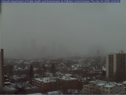
Where's Denver?  This webcam view from the Colorado Department of Public Health and Environment shows Denver obscured in the snowfall at 1:00pm Thursday.
Where's Denver? This webcam view from the Colorado Department of Public Health and Environment shows Denver obscured in the snowfall at 1:00pm Thursday.

If you can, get out of work early today as the roads are sure to be a mess during rush hour.  Snow has been falling across the Front Range all day and snow totals for the metro area are in the 2 to 4 inch range.  Probably just as notable is the bitter cold we are seeing – at 1:00pm DIA was showing 17 degrees and a wind chill of only 2 degrees.  Denver’s high temperature today will most likely be 22 degrees but that was reached at 1:00am!  The wind will continue to keep the wind chills down around zero so bundle up if you head out.

The snow will continue through 11:00pm although accumulations will be pretty light.  The north, west and southern suburbs could see up to 6 inches of snow while the central metro area will end up with around 2 to 4 inches.  Areas of Larimer and Weld Counties including Fort Collins and Greeley will see between 5 to 10 inches of snow. 

A Winter Weather Advisory is in effect for the I-25 corridor north of Longmont as well as most of the central and northern mountains areas.  The extreme eastern portions of the state are under an advisory as well.  In the mountains, eastbound I-70 has chain restrictions in place at the Eisenhower Tunnel, Loveland Pass and at Vail.

Tonight we will dip into the single digits but Friday brings us back into the 40’s and the weekend looks great.

A snowy and slick commute for Thursday

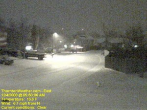
The scene at ThorntonWeather.com at 5:50am today.  Click the image for a current weather webcam view.
The scene at ThorntonWeather.com at 5:50am today. Click the image for a current weather webcam view.

The snow arrived overnight and as of 5:00am ThorntonWeather.com had measured 1.3” and it was still coming down pretty good.  Due to the extreme cold – 17 degrees and a windchill of 5 degrees as of this writing – the roads are quite slick.  This morning we found residential streets to be the worst of course but main arterials like 120th Ave were not in too good of shape either.  Please allow plenty of time to get the kids to school and yourselves to work, allow plenty of distance between you and other cars and just take your time. 

A surge of cold air from the north is expected to intensify the snowfall in the coming hours and a bit of upslope will keep the flakes falling for most of the day.  Accumulations though won’t be all that great – look for 2 to 4 inches overall.  Snow will taper off this evening from the north to the south and completely end in the metro area around midnight.

Friday and this weekend are shaping up great but that could be short lived.  We are watching a cold front coming from Montana that could bring more cold and snow toward the first part of next week.

December weather preview – What to expect

December weather preview - what can we expect in Denver?

December brings with it the official start to winter and at the same time we find ourselves hoping we get moisture in the near future. As of this writing, the mountain snowpack in all basins are well below normal, with some as low as 27% of normal. Here in town our our annual snowfall is well below normal as well. In Colorado the snow season starts on July 1st and between that date and November 30th, Denver averages 16.9 inches of snow. Thus far, ThorntonWeather.com has measured a meager 0.2 inch and the official total for Denver taken at the site of the old Stapleton International Aiport stands at 0.8 inch!

So what can we expect in the coming month?  Click here to read our December 2008 climate and weather preview to find out!

November 23 to 29 – This week in Denver weather history

November 23 to 29 - This week in Denver weather history.

PUBLIC INFORMATION STATEMENT
NATIONAL WEATHER SERVICE DENVER CO
645 PM MST SAT NOV 22 2008

…THIS WEEK IN METRO DENVER WEATHER HISTORY…

21-23

IN 1918…POST-FRONTAL SNOWFALL TOTALED 5.9 INCHES IN DOWNTOWN
DENVER. MOST OF THE SNOW…5.3 INCHES…FELL ON THE 22ND.
NORTH WINDS WERE SUSTAINED TO 20 MPH ON THE 21ST.
IN 1931…A MAJOR STORM DUMPED A TOTAL OF 13.2 INCHES OF
SNOWFALL OVER DOWNTOWN DENVER. MOST OF THE SNOW…11.4
INCHES…FELL ON THE 21ST. A VERY COLD AIR MASS SETTLED
OVER THE CITY AFTER THE HEAVY SNOW ON THE 21ST. AFTER A
LOW TEMPERATURE OF ZERO…THE TEMPERATURE CLIMBED TO A HIGH
OF ONLY 5 DEGREES ON THE 22ND…A RECORD LOW MAXIMUM FOR THE
DATE.

21-25

IN 1952…SNOWFALL OF 6.2 INCHES WAS MEASURED AT STAPLETON
AIRPORT WHERE NORTHEAST WINDS GUSTED TO 17 MPH ON THE
21ST.

Continue reading November 23 to 29 – This week in Denver weather history

November 9th – 15th – This week in Denver weather history

November 9th - 15th - This week in Denver weather history.

Plenty of snow and wind dominate a look back at the Denver weather calendar for this week in weather history – November 9th to the 15th. 

PUBLIC INFORMATION STATEMENT
NATIONAL WEATHER SERVICE DENVER CO
645 PM MST SAT NOV 08 2008

…THIS WEEK IN METRO DENVER WEATHER HISTORY…

8-9   IN 1897…WEST WINDS WERE SUSTAINED TO 45 MPH WITH GUSTS
        AS HIGH AS 50 MPH IN THE CITY.
      IN 1919…POST-FRONTAL HEAVY SNOWFALL TOTALED 8.4 INCHES OVER
        DOWNTOWN DENVER.  MOST OF THE SNOW…6.6 INCHES…FELL ON THE
        9TH.  NORTH WINDS WERE SUSTAINED TO 26 MPH WITH GUSTS TO
        30 MPH ON THE 8TH.
      IN 1950…A MAJOR WINTER STORM DUMPED 10.4 INCHES OF SNOW AT
        STAPLETON AIRPORT WITH THE MOST SNOW…7.8 INCHES…FALLING
        ON THE 8TH.  EAST WINDS GUSTED TO 31 MPH AT STAPLETON
        AIRPORT ON THE 8TH.  SNOWFALL TOTALED 8.2 INCHES IN
        DOWNTOWN DENVER.
      IN 1958…STRONG WINDS CAUSED SOME DAMAGE IN BOULDER.  WEST-
        NORTHWEST WINDS GUSTED TO 40 MPH AT STAPLETON AIRPORT ON
        THE 8TH.
      IN 1975…HEAVY SNOWFALL HIT METRO DENVER.  SNOWFALL AT
        STAPLETON INTERNATIONAL AIRPORT TOTALED 8.0 INCHES AND
        EAST WINDS GUSTED TO 21 MPH.  POWER OUTAGES CAUSED BY THE
        STORM AFFECTED OVER 10 THOUSAND PEOPLE IN METRO DENVER.  IN
        THE FOOTHILLS WEST OF DENVER…10 TO 15 INCHES OF SNOW FELL.
        THE STORM PRODUCED THE GREATEST 24-HOUR PRECIPITATION…1.29
        INCHES…EVER RECORDED DURING THE MONTH OF NOVEMBER IN THE
        CITY.
Continue reading November 9th – 15th – This week in Denver weather history