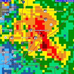
It was quite an eventful afternoon in the Denver metro area as thunderstorms spawned funnel clouds and massive amounts of hail. ThorntonWeather.com’s webcams captured part of the action as the hail piled up enough to make it look like snow.
Our east webcam started to show some light precipitation before 1:00pm and before 3:00pm hail was falling. Mercifully the size of the hail stones remained small but at our location we received a good couple of inches of accumulation. Watch the time lapse video below.
In the area of I-25 and 120th Avenue hail 4 to 5 inches was seen. At the Thornton Multipurpose Fields at 108th and Colorado Blvd where ThorntonFest is to be held this Saturday, the fields were extensively flooded. Images posted by the city to its Facebook page show the mess the rain and hail created.
Funnel clouds were seen across much of the north metro area, mainly in unincorporated Adams County just south of Thornton. As of this writing, no actual tornadoes have been reported.
The Front Range is just beginning to enter its severe weather season. Unfortunately neither the City of Thornton or Adams County provide any sort of warning system to protect residents against the severe weather threat.
Thornton did recently look into alert systems but decided against deploying one. Instead it is waiting for the federal government to deploy its Personal Localized Alerting Network (PLAN). This is disappointing as there are no guarantees that PLAN will launch on time in 2012 or if it will work as advertised. The vast majority of Colorado counties already have systems in place but Thornton and Adams County residents are left without.

