Tag Archives: Hurricane Gustav

As Gustav winds down, Hanna and Ike spool up

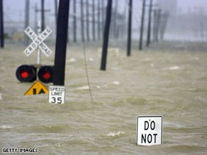
Water from the Industrial Canal floods a road in New Orleans after Hurricane Gustav made landfall Monday. Image courtesy Getty Images.

A weakend Hurricane Gustav came ashore Monday morning shutting down power and swamping much of the Gulf Coast with torrential rain.  Initially making landfall as a category 2 storm, by 3:00pm MDT the storm had lost much of its power and was downgraded to a category 1 system with winds of 80 mph. 

Much of the Louisiana and Mississippi coast lines were subject to extensive rains and high storm surge.  Winds pushed the water over many levees but the Army Corps of Engineers reported no major problems.  The largest provider of electric power in Louisiana, Entergy, said more than 700,000 homes and businesses were without power in the region. 

The Federal Emergency Management Agency (FEMA) reported two Navy boats, each about 350 feet long, that were being scrapped at a facility on the canal broke away from their moorings Monday. They are currently pinned against a wharf in the Industrial Canal but there is concern that should they move they could strike some of the canal walls. 

Much remains to determine the extent of damage from the storm.  The center of the storm is currently north of Lafaette, LA and steadily moving north.  As it does, it will weaken to a tropical storm tonight.
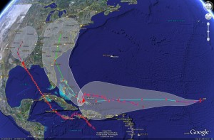
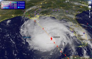
Satellite imagery of the potential tracks of Gustav, Hanna and Ike.  Click for larger version.
Satellite imagery of the potential tracks of Gustav, Hanna and Ike. Click for larger version.

A stark reminder that hurricane season is far from over is the appearance of two additional storms – Hurricane Hanna and Tropical Storm Ike.  Both will bear close watching over the coming days. 

Hanna became a category one hurricane today and as of 3:00pm MDT was  just east of Mayaguana Island in the southeastern Bahamas.  Hanna is expected to meander for a couple of days before making a turn to the northwest with a possible landing anywhere between southern Florida and the Carolinas late this week.   

Ike formed out of a tropical depression today and is currently in the middle of the Atlantic, 1400 miles east of the Leeward Islands moving west at 16 mph.  A warm ocean along Ike’s path is expected to help it reach hurricane strength in the next 36 hours.  It is still very early to tell where Ike will end up but on its current course, it could strike Cuba, the Bahamas and possibly Florida early next week.

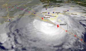
Gustav ready to strike Monday AM

Satellite image of Gustav as of 5:00am MDT showing the storms predicted path.  Click for a larger version.
Satellite image of Gustav as of 5:00am MDT showing the storms predicted path. Click for a larger version.

Hurricane Gustav continues its march to the Louisiana coast Monday morning with landfall expected sometime between 5:00am and 7:00am MDT. At 5:00am MDT the eye of the hurricane was approximately 85 miles south of New Orleans and about 150 miles southeast of Layfayette moving at 16 mph.  Current tracks have it making landfall in the Terrebone / Lafourche areas, just to the east of New Orleans. 

**  Special Coverage:  Click here to view New Orleans radar  **

The good news, if there is any, is that Gustav has not strengthened as was originally expected.  The latest hurricane hunter aircraft report at 3:00am MDT reported sustained winds of 115 mph.  While that is still a category three storm, satellite observations show the storm is not as organized as it could be.  In fact, a station in southwest Pass Louisiana measured only 91mph as Gustav passed over it.  It is important to note that the greatest damage and danger associated with hurricanes is not the winds.  The severe rain, storm surge and the flooding associated with those present the greatest danger.  Rainfall of 6 to 12 inches can be expected and most notably storm surge of 10 to 14 feet. 

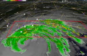
Radar image of Gustav showing current warnings and watches. Click for large version.

Also, one little known additional danger with hurricanes is that of the threat of tornadoes.  In fact, New Orleans and much of the surrounding area is under a Tornado Warning and some twisters have been reported by local law enforcement in Gulfport, MS.  Further, National Weather Service radar indicated the potential for tornadoes right near New Orleans in Jefferson Parish, Southern St. Charles Parish and Plaquemines Parish.

Here are a couple sites with webcams in Louisiana you may wish to check out:

Louisiana DOT

WWLTV.com

Gustav imagery via Google Earth

Below you will find the latest satellite imagery (as of 10:00am MDT) with tracking for Gustav generated with Google Earth.  For those that haven’t played with it, Google Earth is a very fun – and useful – program for any number of tasks.  Using it you can download place files with a wide variety of information including weather related items.  Here are a few links to get your started:

Hurricane Gustav image from Google Earth as of 10:00am MDT Sunday.
Hurricane Gustav image from Google Earth as of 10:00am MDT Sunday. Click on image for larger view.

Evacuations as Gulf Coast prepares for Hurricane Gustav

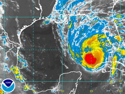
Satellite image of Hurrican Gustav as of 2:00am Sunday.

Residents along the Gulf Coast, particularly in Louisiana, are being ordered to evacuate as Hurricane Gustav bears down on the state.  With Hurricane Katrina still fresh on everyone’s mind, New Orleans is under a mandatory evacuation order and states all along the coast from Texas to Mississippi prepare for a possible hit from Gustav. 

National Hurricane Center forecasters were surprised by how quickly Gustav strengthened in recent days.  Within 24 hours the storm went from a tropical storm to a category 4 hurricane.  Gustav is currently a category 3 storm with sustained winds of 125 mph (gusting to 145 mph) and is expected to intensify in the next 12 hours, possibly reaching category 5 status for a time.  As of 3:00am MT Sunday the storm was 425 miles southeast of the mouth of the Mississippi River and heading northwest at 16 mph. 

By the time it makes landfall, forecasters expect it to be a category 3 storm, possibly a category 4.  The current forecast path for Gustav has it striking the central Louisiana coast with devastating results.  Storm surges of 18 to 25 feet on the eastern side of the hurricane are possible and 6 to 12 inches of rain may fall in Louisiana, southern Mississippi and southern Arkansas. 

John McCain and Sarah Palin await a determination on whether or not the RNC will proceed as scheduled.

In related news, the Republican National Committee was waiting to determine whether or not to proceed with its convention set to begin Monday it St. Paul, MN.  If it proceeds, it is unlikely President Bush would address  the delegates in person Monday as scheduled and would probably do so instead by video link.  John McCain in an interview with Chris Wallace of Fox News said, “It just wouldn’t be appropriate to have a festive occasion while a near-tragedy or a terrible challenge is presented in the form of a natural disaster.  So we’re monitoring it from day to day, and I’m saying a few prayers, too.”

For more information:

National Hurricane Center

2008 Republican National Convention