Tag Archives: January Weather

December 28 to January 3: This Week in Denver Weather History

This Week In Denver Weather History
December 28 to January 3: This Week in Denver Weather History

Powerful, damaging wind, bitter cold and major snowstorms mark our look back at this week in Denver weather history.

From the National Weather Service:

25-31

In 1980…temperatures were unusually warm during the week between Christmas and New Year’s. High temperatures for the week ranged from the mid-50’s to the mid-70’s. Four temperature records were set. Record highs occurred on the 26th with 68 degrees…the 27th with 75 degrees…and the 30th with 71 degrees. A record high minimum temperature of 41 degrees occurred on the 27th.

26-28

In 1979 a heavy snow storm dumped 6 to 10 inches of snow over the metro area and 15 to 20 inches at Boulder with up to 2 feet in the foothills west of Boulder. Heavy snowfall totaled 6.0 inches at Stapleton International Airport where north winds gusted to 21 mph. Most of the snow… 4.8 inches…fell on the 27th.

27-28

In 1997…high winds combined with fresh snow from a previous storm caused highways to become slick from drifting snow and near whiteout conditions in localized ground blizzards. Strong winds blew snow across the runways at Centennial Airport…which glazed over and formed areas of ice. Two planes were damaged when they slid off the runway while landing. No injuries were reported. Numerous accidents also occurred on I-25 and I-70 as ice formed under the same conditions. A rollover accident which injured 4 people on State Highway 93 near the Rocky Flats Environmental Test Facility was also attributed to the high winds. The high winds caused an office building and showroom under construction in Golden to collapse. The largest wall was 180 feet long and 28 feet high. Some high wind reports included: 86 mph at Golden Gate Canyon…72 mph near Conifer…and 70 mph at Jefferson County Airport and the National Center for Atmospheric Research on the mesa near Boulder. West-northwest winds gusted to 53 mph at Denver International Airport on the 27th.

In 1998…damaging downslope winds formed in and near the foothills. Peak wind gusts ranged from 71 to 114 mph. Numerous trees were blown down in Coal Creek Canyon and near Gross Reservoir. Power lines were blown down… Resulting in scattered outages. Peak wind reports included: 114 mph at Wondervu…92 mph in Golden Gate Canyon…88 mph in Coal Creek Canyon…and 79 mph 8 miles west of Conifer. West winds gusted to 46 mph at Denver International Airport on the 28th.

27-29

In 1983…a second surge of bitter cold air in less than a week was less intense. Record breaking low temperatures of 12 degrees below zero on the 28th and 15 degrees below zero on the 29th were accompanied by 3.7 inches of snowfall and northeast winds gusting to 23 mph.

28

In 2001…brief high winds developed in the foothills west of Denver. Winds gusted to 86 mph on Fritz Peak near Rollinsville. West to northwest winds gusted to 39 mph at Denver International Airport where the temperature climbed to a high of 51 degrees.

28-29

In 1906…a trace of snow fell on both days…which along with a trace of snow on the 5th…was the only snow of the month…ranking the month the second least snowiest December on record.

In 1970…wind gusts to 87 mph were recorded at the National Center for Atmospheric Research in Boulder. Winds gusted to only 46 mph in downtown Boulder. Damage was minor.

In 2006…while metro Denver residents were still digging out from the heavy snowfall and blizzard that occurred on December 20-21…the second major winter storm in a week buried the city and the eastern foothills again in more deep snow. Heavy snowfall ranged from 1 to 2 1/2 feet in the foothills and from 6 to 18 inches across the city. Another slow moving storm system centered over the Texas panhandle produced deep upslope flow over the high plains and against the Front Range mountains. The storm produced blizzard conditions over the plains mainly south of interstate 76. Interstate 70 as well as other roads and highways was closed from Denver to the Kansas line due to snow and blizzard conditions. Greyhound was forced to cancel all bus trips from Denver. The heaviest snow fell in and near the foothills and south of Denver over the Palmer Divide…where north winds sustained at speeds of 20 to 30 mph with gusts to 40 mph piled the snow into drifts 4 to 14 feet deep. In the city…the heavy snowfall persisted for a total of 29 hours. Snowfall totals across metro Denver included: 17.5 inches at Ken Caryl; 15 inches 3 miles south-southeast of Morrison; 14 inches in Boulder and lone tree; 12 inches in Castle Rock and Highlands Ranch; 11 inches in Wheat Ridge; 10.5 inches in Littleton; 10 inches in Arvada…Broomfield…and Louviers; and 8.5 inches in Lakewood and Thornton. Officially…snowfall totaled 8.0 inches at Denver Stapleton. North winds sustained to 25 mph with gusts to 32 mph produced some blowing snow at Denver International Airport. In the city…this second storm increased the total snowfall for the month to 29.4 inches…making the month the third snowiest on record. In the foothills the snow fell at a rate of 3 to 4 inches an hour at times. Total snowfall in the foothills included: 30 inches near Genesee; 29.5 inches 12 miles northwest of Golden; 25 inches in Evergreen and near Bergen Park; 24 inches near Conifer; 23.5 inches 3 miles southwest of Golden and near gold hill; 23 inches near Jamestown; 22.5 inches in Rollinsville; 19.5 inches in Aspen Springs; 19 inches near Blackhawk; 18.5 inches at Nederland; 16 inches in Indian Hills…at Intercanyon…and in Eldora; 15.5 inches at Echo Lake; and 12 inches near Ralston Reservoir. The total cost of snow removal just at Denver International Airport from this storm and the previous storm was in tens of millions of dollars. The airport estimated up to 6.7 million dollars in extra costs for contractors…overtime…equipment…de-icing chemicals…and other expenses. The two storms cost the airport 4.6 million dollars in loss concession revenues. United airlines reported lost revenue of over 25 million dollars from the two storms…while frontier airlines lost an estimated 12.1 million dollars.

29

In 1997…high winds persisted mainly in and near the foothills. Strong cross winds gusting between 60 and 70 mph blew a rental truck off the roadway in northern Jefferson County near the Coal Creek Canyon road. West winds gusted to 33 mph at Denver International Airport.

In 2005…high winds were recorded across metro Denver. Peak wind gusts included 75 mph near Chatfield Reservoir and 64 mph at Denver International Airport. No damage was reported.

29-30

In 1898…heavy snowfall totaled 6.2 inches in downtown Denver. Northeast winds were sustained to 35 mph with gusts to 40 mph on the 29th.

In 1912…strong winds buffeted Boulder…causing hundreds of dollars damage. The winds were described as one of the most terrific in the history of the city.

In 1923…a cold wave caused temperatures to plunge 58 degrees in 24 hours. The temperature was 54 degrees at 2:00 pm on the 29th and only 4 degrees below zero at the same time on the 30th. The low temperature of 14 degrees on the 29th was the high temperature on the 30th. The low temperature on the 30th dipped to 10 degrees below zero. Light snowfall totaled only 0.7 inch. Northeast winds were sustained to 23 mph on the 29th.

In 2008…very strong Chinook winds blasted areas in and near the foothills of Boulder and Jefferson counties. The wind blew down trees and power poles…downed electrical lines and fences…and damaged homes and vehicles. Scattered power outages were reported along the Front Range. In metropolitan Denver alone…24000 Xcel customers were affected by the outages. Four planed were damaged at the Vance Brand Municipal Airport in Longmont…one was heavily damaged. Insurance companies estimated up to 7 million dollars in damage. Peak wind gusts included 87 mph at the National Wind Technology Center…86 mph…2 miles north of Longmont; 77 mph at Erie…and 75 mph at Lafayette. On the 30th…a peak wind gust to 47 mph was recorded at Denver International Airport. .

30

In 1875…snow fell from the early morning into the early evening. While the amount of snowfall was not recorded… Precipitation from melted snow totaled 0.53 inch. Good sleighing was reported…so snowfall must have been 5 inches or more.

In 1895…northwest winds were sustained to 60 mph in the city.

In 1897…west winds sustained to 52 mph with gusts to 60 mph warmed the temperature to a high of 55 degrees.

In 1912…west winds were sustained to 48 mph with gusts to 52 mph. The Chinook winds warmed the temperature to a high of 50 degrees.

In 1928…snowfall was 0.1 inch in downtown Denver. This was the only measurable snow of the month…ranking the month the third least snowiest on record in the city.

In 1990…strong downslope winds buffeted the eastern foothills. Wind gusts to 91 mph were recorded atop Table Mesa in southwest Boulder…while a gust to 94 mph was clocked at Rollinsville. The high winds caused whiteout conditions due to blowing snow along some highways south and north of Boulder. The high winds downed power lines near the Rocky Flats plant south of Boulder.

In 1998…high winds continued to buffet areas in and near the foothills. Near Evergreen…a 100-foot-high blue spruce crashed down on the roof of a home…splitting the corrugated metal roof in half. Fortunately…the tree… Which measured 10 feet in circumference…only penetrated the home’s interior in a few places. Peak wind reports included: 90 mph at Wondervu…88 mph at the Rocky Flats test facility…83 mph near Conifer…and 82 mph atop Blue Mountain near Coal Creek Canyon. West winds gusted to 39 mph at Denver International Airport.

Continue reading December 28 to January 3: This Week in Denver Weather History

January 2014 weather recap: Near average temps but well above normal snowfall

January 2014 could be remembered as a month that brought a weather rollercoaster.  Looking back it seems as if we were constantly jumping between mild temperatures to cold to warmth and back to cold again.

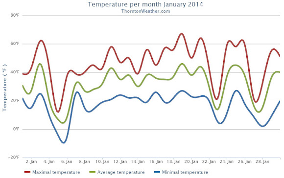
The month started out cooler than normal for the first two days with a light shot of snow on New Year’s Day.  Temperatures then shot into the 60s on the 3rd but were followed by colder temperatures and more snow on the 4th.  On the 5th we registered our coldest day of the month.

From the 7th to the 16th we experienced relatively calm conditions and only very light snow on one day.  We saw above normal temperatures from the 15th to the 21st.  Two cold days followed with snow falling on the 23rd.

Alternating above-normal and below-normal temperatures closed out the month.  Four of the last five days saw snowfall.

Thornton recorded an average monthly temperature of 31.3 degrees.  This was slightly higher than Denver’s official recording of 31.2 degrees.  Both were slightly above the historical average January temperature of 30.7 degrees.

Temperatures in Thornton ranged from a high of 67.0 degrees on the 19th down to a low of -5.5 degrees on the 6th.  Denver’s warmest temperature of 65 degrees also occurred on the 19th and it recorded its coldest of -10 degrees on the 5th.

All 31 days of the month saw low temperatures below freezing in Thornton and four days saw high temperatures fail to reach 32 degrees.  Two days saw readings below zero.  Denver’s readings were similar with four days staying below freezing and three seeing lows below zero.

Precipitation for the month was nearly double of the Denver historical average thanks to snowfall that was about double of normal.

Thornton recorded 1.06 inch of liquid precipitation, well above the average of 0.41 inch. Denver saw a bit less with 0.94 inch.

While no major snowstorms were seen, there were plenty of smaller events.  These gave Thornton 13.4 inches of the white stuff during the month, Denver saw 14.3 inches.  Both were about double the January average of 7.1 inches.  The official Denver measurement propelled January 2014 into the books as the 11th snowiest January on record.

Thornton, Colorado January 2014 temperature summary.
Thornton, Colorado January 2014 precipitation summary.
CLIMATE REPORT
NATIONAL WEATHER SERVICE BOULDER, CO
517 AM MST SAT FEB 1 2014

...................................

...THE DENVER CO CLIMATE SUMMARY FOR THE MONTH OF JANUARY 2014...

CLIMATE NORMAL PERIOD 1981 TO 2010
CLIMATE RECORD PERIOD 1872 TO 2014

WEATHER         OBSERVED          NORMAL  DEPART  LAST YEAR`S
                 VALUE   DATE(S)  VALUE   FROM    VALUE  DATE(S)
                                          NORMAL
................................................................
TEMPERATURE (F)
RECORD
 HIGH              76   01/27/1888
 LOW              -29   01/09/1875
HIGHEST            65   01/19        76     -11       66  01/24
LOWEST            -10   01/05       -29      19      -12  01/12
AVG. MAXIMUM     44.9              44.0     0.9     44.6
AVG. MINIMUM     17.3              17.4    -0.1     16.0
MEAN             31.1              30.7     0.4     30.3
DAYS MAX >= 90      0               0.0     0.0        0
DAYS MAX <= 32      4               5.5    -1.5        6
DAYS MIN <= 32     30              29.4     0.6       30
DAYS MIN <= 0       3               1.7     1.3        5 

PRECIPITATION (INCHES) 
RECORD 
 MAXIMUM         2.35   1883 
 MINIMUM         0.01   1933           
                        1934       
                        1952 
TOTALS           0.94              0.41    0.53     0.31 
DAILY AVG.       0.03              0.01    0.02     0.01 
DAYS >= .01         9               4.1     4.9        4
DAYS >= .10         3               0.9     2.1        1
DAYS >= .50         0               0.0     0.0        0
DAYS >= 1.00        0               0.0     0.0        0
GREATEST
 24 HR. TOTAL    0.26   01/30 TO 01/31           01/28 TO 01/29
                                                          01/29 TO 01/29
                                                          01/29 TO 01/29
 STORM TOTAL       MM                                 MM
 (MM/DD(HH))            MM                    01/29(00) TO 01/29(00)
                                                 01/29(00) TO 01/29(00)9
                                                 01/29(00) TO 01/29(00)9

SNOWFALL (INCHES)
RECORDS
 TOTAL             MM   MM
TOTALS           14.3               7.0

DEGREE_DAYS
HEATING TOTAL    1046              1063     -17     1067
 SINCE 7/1       3497              3531     -34     3300
COOLING TOTAL       0                 0       0        0
 SINCE 1/1          0                 0       0        0

FREEZE DATES
RECORD
 EARLIEST     09/08/1962
 LATEST       06/08/2007
EARLIEST                        10/07
LATEST                          05/05
..........................................................

WIND (MPH)
AVERAGE WIND SPEED              10.7
RESULTANT WIND SPEED/DIRECTION   4/230
HIGHEST WIND SPEED/DIRECTION    36/290    DATE  01/12
HIGHEST GUST SPEED/DIRECTION    44/280    DATE  01/12

SKY COVER
POSSIBLE SUNSHINE (PERCENT)   MM
AVERAGE SKY COVER           0.50
NUMBER OF DAYS FAIR           10
NUMBER OF DAYS PC             14
NUMBER OF DAYS CLOUDY          7

AVERAGE RH (PERCENT)     56

WEATHER CONDITIONS. NUMBER OF DAYS WITH
THUNDERSTORM              0     MIXED PRECIP               0
HEAVY RAIN                0     RAIN                       0
LIGHT RAIN                0     FREEZING RAIN              0
LT FREEZING RAIN          0     HAIL                       0
HEAVY SNOW                2     SNOW                       5
LIGHT SNOW               11     SLEET                      0
FOG                      11     FOG W/VIS <= 1/4 MILE      4
HAZE                      4

-  INDICATES NEGATIVE NUMBERS.
R  INDICATES RECORD WAS SET OR TIED.
MM INDICATES DATA IS MISSING.
T  INDICATES TRACE AMOUNT.

January 2014 in pictures: Monthly photo slideshow

January 3, 2014 - Stunning wave cloud sunset as seen from Brighton.  View more images in the slideshow below. (Brandi Donahue)
January 3, 2014 – Stunning wave cloud sunset as seen from Brighton. View more images in the slideshow below. (Brandi Donahue)

While typically a cold month, January is oftentimes lacking in terms of weather drama.  Living in Colorado however provides plenty of opportunity to capture a wide variety of weather-related imagery as we see in our January 2014 slideshow.

  • Slideshow updated January 31, 2014

In this, our first monthly photo slideshow, we feature photos that not only we have taken but also those taken by ThorntonWeather.com fans.

Throughout the month we will gather the images sent to us via email or shared with us via our various social media outlets and post them in the slideshow below.

With us only being one week into the month, great photos of sunsets, wildlife, pets and wintry conditions have emerged.  We love them all!

To learn more about getting your photos added to our monthly slideshow, click here. 

Click the play button below and sit back and enjoy the images.

Live social feed: Thornton’s late January snowstorm

ThorntonWeather.com on Facebook, Google+ and TwitterThe stage is set for Thornton to receive its most significant snowfall of the season thus far.  Up in the high country snowfall will be measured in feet.

Here at lower elevations current forecasts are calling for 5 to 10 inches between Thursday and Friday afternoon.  Many variables are in play that could affect the total that is eventually realized but this is certainly our best shot at a heavy snow thus far in the snow season.

We will be monitoring monitoring the storm very closely and posting regularly to our Facebook page and Twitter feed.  You can follow along in real time below.  We are also on Google+ here.

For comprehensive look at the storm, please monitor our Winter Weather Briefing page.


Video captures chain reaction multi-car crash on I-25 near Colorado Springs

A screen capture shows the moment of impact during one of a series of accidents on I-25 Saturday, January 4, 2014.
A screen capture shows the moment of impact during one of a series of accidents on I-25 Saturday, January 4, 2014. (YouTube / coach tone)

As temperatures dropped and the snow fell Saturday across Colorado, roads became ice-coated and driving conditions worsened. Video captured near Colorado Springs captured a harrowing multi-car pileup on Interstate 25 that highlighted the dangerous road conditions.

Posted by a user Anthony Salazar to KOAA-5 television’s Facebook page, the video is taken from an overpass in the Colorado Springs area on Saturday, January 4.

Showing I-25 southbound, some drivers are shown exercising appropriate caution on the icy roads and proceeding slowly. Calamity ensues when others are less aware of the conditions.

Read the rest of this story and check out the amazing video on Examiner.com

Thornton’s January weather preview: Usually a cold month but not always snowy

Denver's January weather and climatology preview for 2013.As we begin the new year the winter chill begins to set in.  While January can see its share of extremes, the month historically sees stable temperatures and is usually relatively dry.

January ranks as the second coldest month in Denver next to December with average temperatures remaining virtually the same from the start to the end of the month.  In terms of snowfall, the month only ranks as the fourth snowiest and it is not uncommon for it to be quite dry.

What does January 2013 hold for us?  Indications are that we may very well continue the recent pattern of below normal temperatures and relatively dry conditions.

For the complete January preview including a look at historical averages and extremes, click here. 

January 2013 Thornton weather recap: A colder and drier than average month

Looking back at January 2013 the numbers reveal a month that wasn’t particularly extraordinary by any measure.  Temperatures were slightly below average and precipitation was a bit less than normal.

The first half of the month was notable for cold while the second half for the most part was considerably warmer.

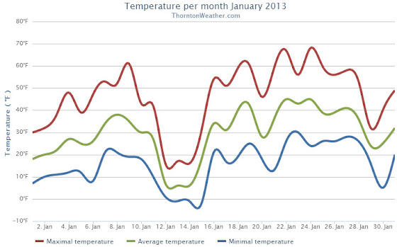
Temperatures for the first three days were well below normal before we entered a brief period with above average temperatures.  That was followed by very cold days on the 12th and 13th when high temperatures only reached the teens.  Most of the following two weeks were notable for highs in the 50s and 60s.

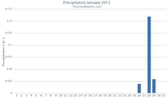
The month started out extraordinarily dry with a mere 0.3 inch of snow being recorded during the first 27 days.  On the 28th though we received a decent little shot of snow to drive up the numbers.

The average temperature for the month came in at 29.7 degrees.  This was a full degree below the Denver January average of 30.7 degrees.  At the official Denver station at Denver International Airport, the monthly average was slightly warmer at 30.3 degrees.

Temperatures in Thornton ranged from a high of 67.8 degrees on the 24th down to a low of -2.4 degrees on the 15th.  Denver recorded a highest temperature of 66 degrees, also on the 24th, and a low of -12 degrees on the 12th.

There were no temperature records set during the month.

In terms of precipitation, an anemic 0.21 inch was measured in Thornton while Denver fared better with 0.31 inch.  The January average is 0.41 inch so both locations were a good bit below normal.

Snowfall was similarly light with Thornton recording 3.7 inches, most of which fell during the storm on the 28th and 29th.  Out at DIA Denver officially measured 4.6 inches for the month.  Average for January is 7.0 inches.

None of the precipitation or snowfall measurements were records.

Click here to view Thornton’s January 2013 Climate Summary

2013-02-01_161619.jpg
Thornton, Colorado January 2013 Temperature Summary. (ThorntonWeather.com)
2013-02-01_161652.jpg
Thornton, Colorado January 2013 Precipitation Summary. (ThorntonWeather.com)

From the National Weather Service:

...THE DENVER CLIMATE SUMMARY FOR THE MONTH OF JANUARY 2013...

CLIMATE NORMAL PERIOD 1981 TO 2010
CLIMATE RECORD PERIOD 1872 TO 2013

WEATHER         OBSERVED          NORMAL DEPART LAST YEAR`S
                 VALUE   DATE(S) VALUE   FROM    VALUE DATE(S)
                                          NORMAL
................................................................
TEMPERATURE (F)
RECORD
 HIGH              76   01/27/1888
 LOW              -29   01/09/1875
HIGHEST            66   01/24        76     -10       66 01/21
LOWEST            -12   01/12       -29      17       -6 01/11
AVG. MAXIMUM     44.6              44.0     0.6     50.3
AVG. MINIMUM     16.0              17.4    -1.4     21.6
MEAN             30.3              30.7    -0.4     36.0
DAYS MAX >= 90      0               0.0     0.0        0
DAYS MAX = .01         4               4.1    -0.1        4
DAYS >= .10         1               0.9     0.1        1
DAYS >= .50         0               0.0     0.0        0
DAYS >= 1.00        0               0.0     0.0        0
GREATEST
 24 HR. TOTAL    0.22   01/28 TO 01/29

SNOWFALL (INCHES)
RECORDS
 TOTAL           24.3   1992
TOTALS            4.6               7.0

DEGREE_DAYS
HEATING TOTAL    1067              1063       4      891
 SINCE 7/1       3300              3531    -231     3325
COOLING TOTAL       0                 0       0        0
 SINCE 1/1          0                 0       0        0

FREEZE DATES
RECORD
 EARLIEST     09/08/1962
 LATEST       06/08/2007
EARLIEST                        10/07
LATEST                          05/05
..................................................

WIND (MPH)
AVERAGE WIND SPEED              8.8
RESULTANT WIND SPEED/DIRECTION   4/205
HIGHEST WIND SPEED/DIRECTION    38/290    DATE 01/24
HIGHEST GUST SPEED/DIRECTION    45/290    DATE 01/24

SKY COVER
POSSIBLE SUNSHINE (PERCENT)   MM
AVERAGE SKY COVER           0.50
NUMBER OF DAYS FAIR            8
NUMBER OF DAYS PC             20
NUMBER OF DAYS CLOUDY          3

AVERAGE RH (PERCENT)     48

WEATHER CONDITIONS. NUMBER OF DAYS WITH
THUNDERSTORM              0     MIXED PRECIP               0
HEAVY RAIN                0     RAIN                       0
LIGHT RAIN                1     FREEZING RAIN              0
LT FREEZING RAIN          0     HAIL                       0
HEAVY SNOW                1     SNOW                       1
LIGHT SNOW                5     SLEET                      0
FOG                       7     FOG W/VIS

January 27 to February 2: This Week in Denver Weather History

This Week In Denver Weather History
January 27 to February 2: This Week in Denver Weather History

High wind and heavy snow events dominate our look back at this week in Denver weather history. Most notable is a major snowstorm just last year that helped to provide at least some relief from tinder dry conditions. Hopefully we can see some of that this year!

From the National Weather Service:

25-27

In 1897…a cold spell resulted in three temperature records. Low temperature of 14 degrees below zero on the 27th was a record minimum for the date. High temperatures of only 3 degrees on the 25th and 2 degrees on the 26th were record low maximums for the dates. Very light snow or flurries fell on the 25th and 26th at times.

26-27

In 1944…heavy snowfall totaled 8.0 inches in downtown Denver. Most of the snow…7.0 inches…occurred on the 26th when northwest winds were sustained to 17 mph.

In 1973…at Stapleton International Airport…only 3.8 inches of snowfall were measured and north winds gusted to 40 mph causing some blowing snow…while over the Colorado eastern plains heavy snow accompanied by high winds created widespread blizzard conditions closing many highways.

In 1994…the combination of an upper level storm system and moist upslope winds brought heavy snow and cold temperatures to metro Denver and much of eastern Colorado. Snowfall across metro Denver averaged 5 to 7 inches. Snowfall totaled 3.8 inches at Stapleton International Airport where east winds gusted to 21 mph on the 26th.

In 2000…snow…heavy in the mountains…spread over the foothills and metro Denver. Eight inches of snow were measured at Bergen Park and near Evergreen. Snowfall totaled 3.8 inches at the site of the former Stapleton International Airport.

26-1

In 1888…a protracted warm spell lasted a week. Maximum temperatures ranged from 62 degrees on the 29th to an all-time record high for the month of 76 degrees on the 27th. Daily record high temperatures of 76…69…and 71 occurred on the 27th…28th…and 30th respectively. Record high minimum temperatures of 47 and 34 occurred on the 26th and 27th.

27

In 1888…the highest recorded temperature in January…76 degrees…occurred.

In 1967…strong winds caused a power outage in Boulder.

In 1984…this was the last day of 63 consecutive days with snow cover of one inch or more in Denver. This longest period of snow cover on record began with the Thanksgiving weekend blizzard on November 26-27…1983… When 21.5 inches of snow fell at Stapleton International Airport. Additional snowfall during December and January prolonged the event. Snow depth on the ground to the nearest inch was measured once daily at 5:00 am MST.

27-28

In 1899…snowfall totaled 6.2 inches in the city. Northeast winds were sustained to 36 mph with gusts to 40 mph on the 28th.

In 1965…high winds raked the Front Range foothills. West winds gusted to 89 mph on Table Mountain in Boulder…87 mph at Rocky Flats…and 54 mph at Stapleton International Airport. Damage and minor injuries occurred in Boulder and western metro Denver. Four men were injured by wind- caused accidents while working on construction…2 in Denver and 2 in Boulder. There was extensive damage to power lines… Buildings…signs…and trees. Some minor accidents were caused by blowing dust and debris. Blown dust accumulated 2 to 3 feet deep on some lawns in northern metro Denver suburbs. Dust blew into buildings and homes.

In 1989…the heaviest snowstorm of the winter dumped 9 to 15 inches of snow across metro Denver. Snowfall totaled 8.8 inches at Stapleton International Airport with most of the snow…8.6 inches…falling on the 28th. Strong north winds gusting to 46 mph whipped the snow into 2-foot drifts and reduced visibility in blowing snow. The foothills received up to 18 inches of snow. The snow fell on a weekend…so closures and other disruptions were minimal. The public reported thunder in Arvada…Wheat Ridge…and Boulder on the evening of the 27th. A thunderstorm produced snow pellets at Stapleton International Airport during the early morning hours of the 28th. This was the first thunderstorm in the city during January since 1932.

In 1996…winds to hurricane force were reported across the Front Range foothills in the wake of a pacific storm system. Recorded wind speeds included: 86 mph at the National Center for Atmospheric Research southwest of Boulder…86 mph atop Squaw Mountain west of Denver…and 75 mph at Jefferson County Airport in Broomfield. West-northwest winds gusted to 48 mph at Denver International Airport on the 28th.

In 2009…high winds buffeted the foothills of Boulder and Jefferson counties. Peak wind gusts included: 101 mph at Eldora Ski Resort…100 mph…6 miles northwest of Boulder; 84 mph at NCAR Mesa Lab…79 mph…5 miles northwest of Boulder; and 75 mph at the national wind technology center. In Nederland…a wind turbine recently installed was damaged by the high winds. A peak wind gust of 38 mph occurred at Denver International Airport on the 28th.

27-31

In 1951…a major storm dumped 10.1 inches of snowfall at Stapleton Airport. Most of the snow…8.3 inches…fell on the 29th. Cold arctic air accompanied the snow. Several temperature records were set…including record low maximum temperatures of 4 on the 28th and 4 below zero on the 29th and record low temperatures of 12 below zero on the 29th and 24 below zero on the 31st. Temperatures were below zero for 45 consecutive hours.

Continue reading January 27 to February 2: This Week in Denver Weather History

North-central Colorado snowpack at second lowest level to date in 34 years

The 2012 / 2013 snow season has been dismal and while December brought some hope for recovery, recent weeks have seen snowpack decline once again.  For the drought and fire weary state of Colorado the data does not bode well.

For the north-central Colorado mountains, the January 22 snowpack is at its second lowest level to date since 1979.  Only 1981 saw worse results this far into the season.

According to the latest Colorado SNOTEL reports, the South Platte, North Platte and Upper Colorado River basins are at 57%, 65% and 60% of normal respectively.  Statewide Colorado snowpack is a dismal 62% of average.

Is there hope?  Mother Nature certainly works on her own schedule so it is possible we could see a recovery.  However the latest 3-month outlook from the Climate Prediction Center forecasts warmer and drier than normal temperatures.

North-central Colorado snowpack through January 22. (NRCS)
North-central Colorado snowpack through January 22. Click the image for a larger view. (NRCS)

January 20 to January 26: This Week in Denver Weather History

This Week In Denver Weather History
January 20 to January 26: This Week in Denver Weather History

Damaging wind events dominate our look back at this week in Denver weather history. Also making appearances are extreme cold and significant snowstorms.

14-21

In 1930…a protracted cold spell occurred when low temperatures plunged below zero on 8 consecutive days. The coldest low temperatures of 20 degrees below zero on the 17th and 19 degrees below zero on the 16th were record minimums for the dates. High temperatures during the period ranged from 18 on the 18th to zero on the 20th. Two degrees on the 15th was a record low maximum temperature for the date.

15-23

In 1962…a protracted cold spell kept metro Denver in the deep freeze for more than a week. From the 15th thru the 23rd…low temperatures were zero or below for 9 consecutive days…but a daily record low was set only on the 22nd when the temperature dipped to 14 degrees below zero. A record low maximum for the date was also set on the 22nd when the temperature climbed to only 11 degrees. The coldest high temperature was 3 degrees above zero on the 21st…which did not break the record. The protracted cold was broken for only a few hours on the afternoon of the 20th when Chinook winds warmed the temperature to a high of 38 degrees before another surge of cold arctic air plunged temperatures back into the deep freeze that evening. The severe cold caused much damage to water systems. A woman was frozen to death at Morrison. There were other deaths attributable to the weather…including traffic deaths and heart attacks from overexertion.

18-20

In 1958…snowfall totaled 6.9 inches at Stapleton Airport where east-northeast winds gusted to 26 mph on the 18th.

18-24

In 2005…a week of mid-winter unseasonably warm weather pushed high temperatures into the 60’s or more on all but one day. During the period…the highest temperature of 70 degrees on the 20th was a new record maximum for the date. Low temperatures remained above freezing on 4 of the days.

19-20

In 1935…snowfall of only 0.8 inch during the evening of the 19th was the only measurable snowfall of the month. The light snow developed behind an arctic cold front as temperatures plunged to a low of 13 degrees below zero on the 20th. High temperature of only 2 degrees on the 20th was a record low maximum for the date. Northeast winds were sustained to 16 mph on the 19th.

In 1986…Chinook winds gusting to 39 mph at Stapleton International Airport provided record breaking warmth. The warmest temperature of the month…68 degrees on the 19th…was also a record high for the date. The low temperature of 41 degrees on the 20th equaled the record high minimum for the date.

In 1991…a strong cold front moved south across metro Denver. Upslope conditions produced 3 to 6 inches of snow along the Front Range with 5 inches in Westminster and 4 inches in Thornton. Snowfall measured 4.9 inches at Stapleton International Airport where north winds gusted to 31 mph.

20

In 1894…northwest winds were sustained to 40 mph with gusts to 45 mph in the city.

In 1911…west Chinook winds sustained to 46 mph warmed the temperature to a high of 62 degrees.

In 1975…a warm Chinook wind produced a west wind gust to 53 mph at Stapleton International Airport. Winds were much stronger near the foothills…where 80 mph winds in Boulder caused damage to homes…buildings…power lines… And autos.

In 1986…high winds buffeted the foothills from Denver north. The strongest reported wind was 72 mph in Fort Collins. A wind gust to 39 mph was reported at Stapleton International Airport in Denver.

In 1996…high winds developed for a short time in the Front Range foothills in the wake of a weak upper level disturbance. Wondervu recorded a peak wind gust to 90 mph… While winds gusted to 84 mph atop squaw mountain near Idaho Springs. West winds gusted to only 29 mph at Denver International Airport.

In 2011…a snowboarder and his dog were killed when he triggered an avalanche in the backcountry northeast of Berthoud Pass.

20-21

In 1973…a major storm produced 7.5 inches of snowfall at Stapleton International Airport where north winds gusted to 32 mph causing some blowing snow.

In 2002…high winds developed over portions of the northern mountains and Front Range foothills. Several trees were blown down in Gilpin County along State Highways 119 and 46. Wind gust reports included: 90 mph 11 miles north of Central City…83 mph near Fritz Peak…76 mph at Aspen Springs…and 80 mph at Nederland. West winds gusted to only 39 mph at Denver International Airport on the 20th.

Continue reading January 20 to January 26: This Week in Denver Weather History