Tag Archives: July Weather

July 16 to July 22: This week in Denver weather history

This Week In Denver Weather History
July 16 to July 22: This Week in Denver Weather History

Our weekly look back at Denver weather history always has interesting items but this week one stands out in particular. Denver has never officially recorded snow during the month of July. However, before official records began in 1882, the U.S. Army Signal Service weather observer reported snow on July 17, 1872!

From the National Weather Service:

7-25

In 1934…a streak of 15 consecutive days of 90 degrees ranked 5th on the list of hot streaks. The record of 24 consecutive days was established in the summer of 2008.

13-5

In 2008…a streak of 24 consecutive days of 90 degrees shattered the previous record of 18 consecutive days established in 1901 and 1874. Ironically…no new single day record high temperatures were set in the month of July. In August however…a record of 104 degrees was set on the 1st…and another record of 103 degrees was set on the 2nd. In addition…a record low min of 70 degrees was set on August 2nd.

15-16

In 2006…a brief mid July hot spell resulted in two 100 plus degree high temperatures and two daily maximum temperature records. The high temperature climbed to 101 degrees on the 15th and 103 degrees on the 16th at Denver International Airport.

16

In 1911…thunderstorm winds were sustained to 44 mph from the northwest.

In 1959…a thunderstorm produced 3/8 inch diameter hail and a wind gust to 60 mph at Stapleton Airport.

In 1972…two tornadoes were sighted by the public to the southeast of Aurora. No damage was reported.

In 1978…a thunderstorm wind gust to 52 mph was recorded at Stapleton International Airport.

In 1980…a severe thunderstorm ripped through metro Denver… Producing torrential rain…large hail…and strong winds. In Aurora…winds gusted to 65 mph with hail up to 1 1/2 inches in diameter and half an inch of rain in just 10 minutes. Stapleton International Airport was closed for an hour. Large hail also fell in southeast Denver…Lakewood…Parker… And Castle Rock. Up to 1 1/2 inches of rain fell in just 40 minutes. Heavy rains in wheat ridge flooded a shopping center…breaking windows and doors…while causing 100 thousand dollars in damage. Some roofs and windows were damaged throughout metro Denver. At Stapleton International Airport where west winds gusted to 49 mph…1/4 inch hail and 0.77 inch of rain fell.

In 1983…severe thunderstorms dumped large hail over much of metro Denver. Hail to 3/4 inch in diameter fell in Littleton and Northglenn…with 3/4 to 1 inch hail in Arvada…1 to 1 1/2 inch hail in extreme northwest Denver…1 3/4 inch hail in Lakewood…1 1/2 inch hail in south Arvada and just northeast of Aurora…and 1 5/8 inch hail on Green Mountain.

In 1994…spotters reported a brief tornado touchdown in an open field just north of Fort Lupton. No damage or injuries were reported.

In 2000…very moist and unstable weather conditions…along with low level upslope flow during the late afternoon and evening…combined to produce heavy thunderstorm rainfall… Which caused urban and small stream flooding across metro Denver. Rainfall amounts generally ranged from 1 to 3 inches with the heaviest rainfall occurring during the evening hours. Two miles east of white ranch in northern Jefferson County… An automated rain gage measured 3.86 inches of rain. Since the rain fell in a relatively open area…no flood damage was reported. However…in greenwood village near the intersection of Peoria and Belleview…the streets were closed for several hours with as much as 2 feet of standing water covering the roadways. Two campers near Mt. Evans were injured by lightning and stranded overnight by the inclement weather. Both received minor injuries.

In 2003…the high temperature of 101 degrees was a record maximum temperature for the date.

In 2004…locally heavy rainfall of unknown amount caused parts of the Virginia Canyon Road near Idaho Springs to wash out. The road had to be closed temporarily.

In 2005…the temperature climbed to a high of 102 degrees at Denver International Airport. This was a new record maximum temperature for the date at the time.

16-18

In 1997…an extended hot spell resulted in 3 temperature records being set. The maximum temperature reached 98 degrees on each of the days…setting records on the 16th and 18th. The low temperature of 71 degrees on the 17th was a record high minimum for the date. The high temperature reached 100 degrees on the 17th at the site of the former Stapleton International Airport.

17

In 1872…the U.S. Army Signal Service weather observer recorded snowfall during the early morning hours in the hand written daily weather journal: “rain commenced at 1:30 a.m. changing about 3 a.m. to snow & in about half an hour to rain again; it continued until 6 a.m.” this is the only recorded occurrence of snowfall in Denver in July…but this report is not included in the “official” station snowfall records…which did not begin in Denver until January 1…1882. The low temperature on this morning was 45 degrees…which is sufficiently cold for the occurrence of light stratiform snowfall.

In 1918…a thunderstorm produced hail to an inch in depth on the ground. The stones varied in size from a small cherry stone to nearly 1/2 inch in diameter. Not much permanent damage was done to crops. Precipitation totaled 0.40 inch…and northeast winds were sustained to 25 mph with gusts to 28 mph.

In 1971…the temperature reached a high of 101 degrees at Stapleton International Airport.

In 1983…3/4 inch diameter hail fell at Lafayette…while golf ball size hail pelted Brighton and Northglenn where funnel clouds were also sighted.

In 1986…1 1/2 inches of rain fell in an hour and 15 minutes in southeastern Aurora. Thunderstorm rainfall totaled 0.89 inches at Stapleton International Airport.

In 1987…a small tornado was sighted near Watkins…in the vicinity of Front Range airport.

In 1997…lightning ignited an oil well tank holding 10 thousand gallons of oil…16 miles northwest of Bennett. About 200 acres of grassland burned before the fire could be extinguished. A dry microburst produced a wind gust to 52 mph at Denver International Airport.

In 2000…an estimated 2 inches of rain fell in less than an hour…causing two secondary roads in buck and miller gulches in the hi meadows fire burn area to wash out. Water also covered Jefferson County road 68 which connects to Bailey. Homeowners in pine valley estates attempted to divert some of the runoff by piling stacks of hay on the hillside above their homes. Torrential rainfall…up to 3.50 inches an hour…caused flash flooding along Whiskey Gulch near Elizabeth. Several roads were washed out and basements flooded during the storm. Along County Road 13… About 6 miles north-northwest of Elizabeth…rushing water washed away a 15-foot section of the road. The floodwaters forced debris and mud into four huge culverts…sending water over the road. At Denver International Airport…an United Airlines ground crew worker was struck by lightning as she was loading a Boeing 747 jumbo jet. The woman was injured when lightning either hit the jet or the loading equipment that she was working near. The 25-year-old woman received only minor injuries.

In 2006…outflow from severe thunderstorms to the southeast of metro Denver produced southeast sustained winds to 35 mph with gusts as high as 52 mph at Denver International Airport during the late evening.

In 2011…a deluge of heavy rain occurred in and around Nederland when the storm dumped nearly 2 inches of rain in 30 minutes. The heavy rainfall washed out hillsides and dirt roads. In Nederland…a culvert became blocked with debris and forced the water to spread into a nearby bookstore. The rainfall also damaged several residential roads in the Sunnyside Subdivision and Navajo Road became impassable. Several homes suffered flood damage as the runoff from a nearby Beaver Creek jumped its banks and flooded garages…living rooms and bedrooms of nearby houses.

18

In 1874…the temperature climbed to 90 degrees or more for the 18th consecutive day…setting a record. The record was equaled from July 6th through the 23rd in 1901.

In 1902…a thunderstorm produced northwest winds sustained to 45 mph with gusts to 48 mph along with rain and hail. Total precipitation was 0.53 inch.

In 1911…a shower produced north winds sustained to 44 mph.

In 1958…1 1/2 inch diameter hail fell 9 miles west-southwest of Stapleton Airport.

In 1981…a thunderstorm bombed Evergreen with about 2 inches of rain in 45 minutes. A heavy hailstorm left 5 to 7 inches of hail on the ground in some places and stopped the Colorado Open golf tournament at Hiwan.

In 1985…over 2 inches of rain doused the southwest suburbs of Denver. Street flooding occurred in the Montbello area of northeast Denver.

In 1992…nickel size hail fell across central Douglas County near Castle Rock and Sedalia. One inch diameter hail fell in Castle Rock.

In 1993…thunderstorm winds gusted to 60 mph at Strasburg east of Denver.

In 2004…heavy thunderstorm rainfall caused flooding over parts of the Virginia Canyon Road near Idaho Springs. Several sections of the roadway were washed out. The road was closed temporarily for repairs.

18-19

In 2003…heavy rain producing thunderstorms caused flash flooding across southern metro Denver. Automated rain gages measured 2 to 3 inches of rain in less than an hour. The heavy rainfall caused many intersections and underpasses to flood…stranding motorists. Sections of I-25 and I-225 were closed due to the high water.
18-2

In 1987…a streak of 16 consecutive days of 90 degrees ranked 4th on the list of hot streaks. The record of 24 consecutive days was established in the summer of 2008.

19

In 1875…recent heavy rains produced high waters on many creeks and rivers in the area…which threatened the destruction of property at some locations. Cherry Creek in the city was running the highest in 10 years. Heavy rain in the mining regions over the last 2 days resulted in water running “everywhere” and the suspension of some work.

In 1881…a thunderstorm passing across the city produced lightning with no rain. A woman was seriously injured when struck by lightning several blocks from the weather office in downtown Denver.

In 1934…the temperature reached a high of 100 degrees in downtown Denver.

In 1965…hail…rain…and lightning hit west metro Denver. Hail stones as large as 1 1/2 inches in diameter accumulated to a depth of 2 inches in Evergreen where 2.95 inches of rain in 2 hours caused some flooding in the business section of the town. Lightning caused some power outages.

In 1973…two funnel clouds were observed 5 miles southeast of Littleton. The same funnel clouds were observed for 20 minutes…5 miles west and 5 miles west-southwest of Arapahoe County airport…now centennial airport.

In 1975…lightning injured a man in Denver and caused power outages in Aurora…Lakewood…Westminster…and west Denver.

In 1984…strong thunderstorm winds gusting to 45 mph shattered 7 large plate glass windows at Stapleton International Airport.

In 1985…a tornado touched down in the surrey ridge area of northern Douglas County…just west of I-25. Ten homes were damaged; one under construction was nearly destroyed. Two vehicles were thrown off I-25 injuring three people. A pick-up truck was thrown 50 feet by the twister. In addition…a cluster of severe thunderstorms pounded all of metro Denver with torrential rain…hail…and wind. The heaviest rain fell in Aurora where one location reported 2.37 inches in just 40 minutes. One location in northeast Aurora received a total of 4.30 inches from the storm. There was extensive street and basement flooding…and a number of roads were damaged or washed out. An Aurora boy suffered minor injuries when he was washed into a drainage ditch. Golf ball size hail in Aurora piled up to 5 inches deep. An inch of rain fell in 20 minutes at Stapleton International Airport…closing it to air traffic for an hour. Up to 1 1/2 inches of rain fell in just 15 minutes over central Denver with the high water closing I-25. The water was so deep on the freeway…that one vehicle was completely submerged and people were diving into the water from the freeway overpass. Three homes in Littleton were damaged by lightning. Wind blew out several windows from a high rise apartment building in southeast Denver. Rainfall totaled 1.51 inches at Stapleton International Airport.

In 1997…torrential rain and damaging hail pummeled eastern sections of metro Denver. Hail up to 1.25 inches in diameter fell at the national weather service office on the site of the former Stapleton International Airport. The hail continued for about 15 minutes and accumulated to a depth of 2 to 3 inches…causing extensive damage to cars in the area. Heavy rainfall totaled 3.83 inches in about an hour from the nearly stationary thunderstorm. Numerous cars stalled along I-70…and several homes were flooded in east Denver. The roof of a building collapsed under the weight of the water. The next day several “fatalities” were discovered near the national weather service office; two prairie dogs were found dead along with three rabbits that either drowned or were killed by the large hail.

In 1999…lightning struck two residences in Littleton…but caused only minor damage. Lightning triggered a fire at a residence in cherry hills village. A small portion of the roof and ceiling were damaged before the fire could be extinguished.

In 2000…hail as large as 1.25 inches in diameter fell near roggen northeast of Denver.

In 2004…heavy rainfall caused flooding on the Virginia Canyon Road near Idaho Springs…which had to be closed for repairs.

In 2006…the temperature climbed to a high of 100 degrees. The high temperature was not a record maximum for the date.

In 2007…a severe thunderstorm produced large hail…up to 1 inch in diameter…about 6 miles north of Northglenn.

19-23

In 2005…the high temperature climbed above 100 degrees on each of the 5 days with readings of 101 on the 19th…105 on the 20th…104 on the 21st…and 102 on both the 22nd and 23rd. A new record maximum temperature for the month of July of 105 degrees was set on the 20th…which also equaled the all time record maximum for Denver of 105 degrees first set on August 8th in 1878. Daily maximum temperature records were set on each day…and the 5 day period equaled the record for the most consecutive days of 100 degrees or more first set from July 4th through 8th in 1989. The intense heat resulted in a high use of electricity for cooling purposes. The demand for electric power exceeded the supply and rolling black-outs… Each lasting about an hour…were scheduled across metro Denver during the afternoons and early evenings.

20 Continue reading July 16 to July 22: This week in Denver weather history

July 9 to July 15: This week in Denver weather history
This Week In Denver Weather History
July 9 to July 15: This Week in Denver Weather History

Our look back at this week in Denver weather history demonstrates why July is considered the Mile High City’s stormiest month. Many instances of flooding rains, damaging wind and hail and dangerous lightning are seen in our past.

From the National Weather Service:

1-18

In 1874…a streak of 18 consecutive days of 90 degrees tied for second with another streak that was later set in the summer of 1901. The record of 24 consecutive days was established in the summer of 2008.

1-31

In 2012…it was the hottest July on record in Denver since weather records began in 1872. The average temperature for the month was 78.9 degrees which was 4.7 degrees above normal. There were 27 days in which the high temperature equaled or exceeded 90 degrees…which established a new record. There were also 7 days in which the temperature equaled or exceeded 100 degrees which tied the record set in 2005.

6-23

In 1901…a streak of 18 consecutive days of 90 degrees tied for second with another streak set in the summer of 1874. The record of 24 consecutive days was established in the summer of 2008.

7-25

In 1934…a streak of 15 consecutive days of 90 degrees ranked 5th on the list of hot streaks. The record of 24 consecutive days was established in the summer of 2008.

9

In 1872…a very brisk wind between 2:00 pm and 3:00 pm spread a cloud of dust and sand into the city.

In 1874…northeast winds at sustained speeds up to 36 mph blew immense clouds of dust from the prairie through the streets of the city around mid-morning. The houses across the street from the weather station were not visible at the peak of the storm.

In 1875…heavy thunderstorm rains caused stream flooding… Which damaged nearly all railroads into the city. Rainfall in the city was only 0.14 inch.

In 1953…heavy thunderstorm rains caused an estimated 2 million dollars damage from flooded stores and basements across metro Denver. The flood waters reached a depth of 3 feet on streets in some sections of the city…damaging streets and automobiles. The heavy rainfall at Lowry Air Force Base totaled 3.90 inches. At Stapleton Airport where the heavy rain briefly reduced the surface visibility to 1/2 mile…only 1.05 inches of rain were measured. North winds gusting to 52 mph caused some damage in east Denver.

In 1982…two small tornadoes were spotted east of Rocky Flats… And a tornado touched down briefly 5 miles east of Brighton. No damage was reported.

In 1984…heavy rain fell over southern sections of metro Denver. Rainfall totaled 1.50 inches in just 15 minutes between Littleton and Sedalia.

In 1987…a thunderstorm microburst produced a wind gust of 58 mph at Erie north of Denver.

In 1988…hail to 3/4 inch in diameter piled up 2 to 4 inches deep in Idaho Springs. Some basements were flooded and several thousand gallons of fuel were contaminated when water flooded a gasoline storage tank. A tornado sighted near Manilla 5 miles west of Bennett remained on the ground for 9 minutes. No damage was reported.

In 1990…a severe thunderstorm produced a tornado and heavy rain over northeast metro Denver. As much as 4 inches of rain fell in just 20 minutes in Commerce City…causing the South Platte River to rise quickly and flood lowland areas. The raging flood waters caused extensive damage to a 30-foot stretch of railroad track embankment…destroyed a railroad trestle and a nearby garage…and washed away a vintage 1960’s show car near East 58th Avenue and York Street. The car was found a couple of miles downstream in a pool of deep mud and murky water. Rainfall totaled 1.34 inches at Stapleton International Airport where 1/2 inch diameter hail fell. The same thunderstorm produced a brief tornado in a vacant field near 64th Avenue and Tower Road just east of the Rocky Mountain Arsenal. No damage was reported from the twister. Lightning from the storm caused power outages to as many as 7 thousand homes and businesses.

In 1996…a tornado (F0) was reported 5 miles south of Hudson. No damage was reported. Twin weak tornadoes (F0) formed for a short time near the northeast runways at Denver International Airport. Less than 15 minutes later…a weak tornado (F0) touched down in the employee parking lot at DIA. Several car windows were blown out…and a few vehicles sustained minor body damage from flying debris. Several signs were also blown down. Later…twin weak tornadoes (F0) touched down again in open country between DIA and Watkins.

In 2004…severe thunderstorms produced hail to 3/4 inch in diameter near tiny town and wind gusts to 66 mph in Bennett. A thunderstorm wind gust to 56 mph was measured at Denver International Airport.

In 2005…a thunderstorm produced a wind gust to 54 mph at Denver International Airport.

9-10

In 1980…a series of severe thunderstorms hit metro Denver… Dumping heavy rain and producing a spectacular lightning display lasting for several hours. A number of homes were damaged by lightning. Winds gusted to 60 mph at Stapleton International Airport where about half an inch of rain fell in just 10 minutes along with 1/4 inch diameter hail. The evening thunderstorms continued into the early morning hours with total rainfall of 1.35 inches at Stapleton International Airport.

In 1998…thunderstorm rainfall totaled 2.04 inches at the site of the former Stapleton International Airport.

10

In 1878…a lunar rainbow was observed during a light mist and fog.

In 1895…the temperature warmed to a high of only 53 degrees… The all-time record lowest maximum temperature for the month of July.

In 1967…golf ball size hail damaged aircraft at Jefferson County Airport near Broomfield.

In 1983…two people were injured when struck by lightning just southwest of Morrison. A man was injured when he was swept downstream by a flash flood on a tributary of clear creek in the canyon 8 miles west of Golden. Heavy thunderstorm rains caused mudslides which closed several roads. Rainfall amounts included: 1.75 inches in 20 minutes in southeast Denver…1.26 inches in 35 minutes in Boulder…2.14 inches in 2 hours in Lakewood…1.70 inches in 45 minutes in Aurora…and 1.25 inches in 30 minutes atop Floyd Hill in the foothills west of Denver.

In 1992…storm spotters reported 3/4 inch diameter hail near the construction site of the new Denver airport just northeast of the city.

In 1995…microburst winds toppled a pine tree 60 feet high and 2 feet in diameter in Denver. The tree fell and injured a man nearby. Microburst winds to 59 mph broke the glass on a door at the national weather service forecast office at the site of the former Stapleton International Airport.

In 1998…thunderstorm rainfall totaled 2.35 inches at Denver International Airport.

In 2000…three children were injured…one critically…when lightning hit a nearby tree at panorama point atop Flagstaff Mountain just west of Boulder. Lightning hit the tree…entered the ground…then struck the children. Lightning sparked a grassfire that burned about 50 acres at the Rocky Flats Environmental Test Facility. Also… Lightning sparked at least 6 fires in the Hudson and Keenesburg areas as thunderstorms…accompanied with heavy rain…large hail…and tornadoes…moved through southern Weld County. Over 2 inches of very heavy rain caused flooding along an I-76 exit ramp near Keenesburg. The fire department rescued 15 stranded motorists as high water inundated sections of the exit ramp and adjacent highway. Basements were also flooded in Keenesburg. One home reportedly had 7 feet of standing water in the basement before the rain subsided. A weak tornado (F0) touched down briefly near Brighton…but caused no damage.

In 2001…a severe thunderstorm dumped 7/8 inch diameter hail in wheat ridge.

In 2002…severe thunderstorms pelted the southern suburbs of metro Denver with large hail. Hail as large as 3 inches in diameter fell 6 miles southeast of Parker. Other large hail reports included 2 inch diameter hail around centennial airport and 3/4 inch hail near Sedalia and Deckers. Hail as large as 3/4 inch was also reported in Broomfield. Runoff from heavy thunderstorm rainfall in the Hayman fire burn area flooded lost creek ranch with up to 18 inches of water just off State Highway 126. Floodwaters damaged a very expensive rug in the lodge. A driveway to a residence was washed away. In Douglas County…runoff damaged forest access roads in the Turkey Creek drainage.

In 2011…a severe thunderstorm produced intense microburst winds in southeast Boulder County. A peak wind gust to 75 mph was recorded in Superior with gust to 58 mph…2 miles south of Lafayette. At Denver International Airport…a peak wind gust of 31 mph was recorded.

11

In 1872…heavy rainfall started at 4:00 pm and continued into the night. The heavy rainfall damaged homes and buildings in all parts of the city. Rainfall totaled 1.64 inches.

In 1888…the temperature reached 100 degrees in downtown Denver.

In 1954…the high temperature climbed to 102 degrees at Stapleton Airport.

In 1970…a girl walking in a park in southeast Denver received eye and facial injuries when lightning struck nearby. Lightning also caused numerous power outages and heavy rainfall produced local flooding at several locations across metro Denver.

In 1974…large hail up to 1 1/2 inches in diameter fell in Thornton.

In 1990…the worst hailstorm in American history in terms of dollar damage at the time battered metro Denver. Storm damage totaled 605 million dollars…as it cut a 5-to 10-mile wide swath from just southeast of Estes Park to northeast of Colorado Springs. Hail as large as baseballs (2.75 inches) pounded metro Denver. Hardest hit areas were southeast Boulder County…the Jefferson County Airport in Broomfield… Arvada…east Wheat Ridge…southwest and south-central Westminster…west Thornton…northwest…west-central and downtown Denver…northeast and east-central Lakewood…just east of Littleton…portions of Arapahoe County west of I-25… And northern and central Douglas County near Castle Rock and Franktown. Golf ball to baseball size hail severely damaged roofs on thousands of homes and buildings…battered tens of thousands of automobiles…windows…signs…street lights…and traffic signals…stripped paint…awnings…and trim from buildings…punched holes in the roofs of two homes in Arvada…knocked out power and telephone service to thousands of homes and businesses…defoliated thousands of trees…ripped up greens and fairways on a number of golf courses…and severely damaged several aircraft tied down at Jefferson County Airport. Hail the size of baseballs fell for several minutes in old town Arvada. Later…golf ball size hail and heavy rain pummeled two northwest Denver amusement parks. Hardest hit was Elitch Gardens Amusement Park where 47 people were injured and received treatment for bumps…cuts…and bruises at local hospitals. Many of the injured were stranded on rides during the storm when power failed. Hail clogged storm sewers…causing rain water to back up 3 to 6 feet deep on some roads and intersections in Arvada. Several basements were flooded. In some places hail was washed into drifts several feet deep. In addition… The storm spawned 2 small tornadoes. One touched down briefly in Lakewood near 6th avenue and Kipling Blvd….but did no damage. In Castle Rock…a tornado (F1) did heavy damage to some homes and vehicles in the Founders Village development near Ridge Road.

In 2001…lightning struck two homes in Thornton. Most of the damage was confined to the attics of both homes. Hail as large as 3/4 inch in diameter fell in Keenesburg…Longmont… And near Boulder.

In 2011…severe thunderstorms developed over parts of Adams and Denver Counties. At Denver International Airport…a severe thunderstorm produced a peak wind gust to 66 mph…with another gust to 59 mph measured in Denver. In Commerce City…the intense winds blew down a large tree.

Continue reading July 9 to July 15: This week in Denver weather history
July 2 to July 8: This week in Denver weather history

This Week In Denver Weather History
July 2 to July 8: This Week in Denver Weather History

In our July weather preview we discussed how the month is not only Denver’s hottest but also its stormiest. Our look back at this week in Denver weather history helps to illustrate that fact. We start seeing 100+ degree days as well as many of the types of fast moving thunderstorm events expected this time of year.

From the National Weather Service:

29-2

In 1990…almost a year to date after the record breaking heat in early July 1989…the third longest heat wave in Denver history started. From June 29th through July 2nd the temperature reached 100 degrees or more on four consecutive days. The highest reading of 102 degrees occurred on the 29th…30th…and 1st. Combined with the 102 degree reading on June 27th this would have been the longest heat wave on record…but the temperature climbed to only 98 degrees on June 28th.

29-15

In 2000…the 29th marked the beginning of a near record hot streak for metro Denver. The high temperatures…as recorded at Denver International Airport…exceeded the 90 degree mark for 17 consecutive days from June 29th through July 15th. The record of 24 consecutive 90 degree or above days was set from July 13th through August 5th…2008.

1-18

In 1874…a streak of 18 consecutive days of 90 degrees tied for second with another streak that was later set in the summer of 1901. The record of 24 consecutive days was established in the summer of 2008.

1-31

In 2012…it was the hottest July on record in Denver since weather records began in 1872. The average temperature for the month was 78.9 degrees which was 4.7 degrees above normal. There were 27 days in which the high temperature equaled or exceeded 90 degrees…which established a new record. There were also 7 days in which the temperature equaled or exceeded 100 degrees which tied the record set in 2005.

2

In 1879…a severe hail storm produced considerable damage in the vicinity of Arvada. Some of the stones were unusually large…measuring 6.5 inches in circumference (2 inches in diameter) with an average weight of 1 ounce. The stones were uniformly large with one side concave. The greatest damage was to early wheat…cabbage…and vines. A tree just to the south of the weather station in downtown Denver was struck by lightning. Residents in the house 15 feet away were affected by the strike.

In 1885…thunderstorm winds were sustained to 50 mph in the city.

In 1892…an apparent cold front produced sustained northeast winds to 40 mph with gusts to 45 mph.

In 1955…a apparent microburst wind gust to 69 mph was recorded at Stapleton Airport where the brief strong wind reduced the visibility to zero in blowing dust.

In 1965…hail…up to 2 inches in diameter…struck southwest Adams and northeast Denver counties…damaging cars…windows… And foliage. Hail accumulated up to a foot deep. Wind gusts to 48 mph and hail to 1 inch in diameter fell at Stapleton International Airport where the large hail broke three storm windows and shredded shrubs at the U.S. Weather Bureau Upper Air building.

In 1968…a pilot reported a tornado 10 miles southeast of Parker.

In 1971…one inch diameter hail stones were reported in Adams County about 30 miles east of Denver.

In 1987…a large tornado touched down 10 miles northeast of Stapleton International Airport. The tornado was vertical and thick and kicked up a large dust and debris cloud. Later…it developed a sinuous rope-like shape as it slowly dissipated. The tornado was visible for 15 minutes. The twister occurred in open country and did only minor damage to a metal shed…porch…and mailbox. A man was killed by lightning in southwest Aurora. He was in his backyard and had a shovel in his hand at the time of the strike. A group of soccer players were hit by lightning on a field in Boulder. A 10-year-old boy was critically injured and hospitalized; fortunately he recovered. Six other people were knocked to the ground by the strike. Two of these were slightly injured. Golf ball size hail fell just east of Littleton and at Highlands Ranch. Hail as large as 3/4 inch in diameter was reported in Aurora and Parker and near Hudson and Franktown.

In 1988…a 45-year-old man was injured by lightning at Cheery Creek Reservoir. Administration of CPR probably saved his life.

In 1990…the temperature reached a high of 100 degrees at Stapleton International Airport.

In 1993…thunderstorm winds blew a roof off a barn near Parker…causing an estimated 15 hundred dollars damage.

In 1994…thunderstorm winds downed power lines in Boulder… Causing power outages. Winds gusted to 66 mph in Boulder… 64 mph in Arvada…and 60 mph in Golden.

In 1998…a small tornado touched down briefly near Barr Lake… But caused no damage.

In 2002…hail as large as 1 3/4 inches in diameter fell in the city of Denver and in Arapahoe County near Littleton. The low temperature of 69 degrees equaled the record high minimum for the date.

In 2006…lightning struck a teenager in Castle Rock as he was mowing his lawn and listening to an iPod. The teen suffered burns to his hands and feet…and had blood running from his ears when he was found. The victim’s eardrums were ruptured…which damaged his hearing. Lightning also struck a house in Castle Rock causing extensive damage to the roof and side of the home. Heavy rains caused flash flooding at Castlewood Canyon State Park near Franktown. The floodwaters destroyed four footbridges along the high trail. A culvert and several roads were washed out in the area. In addition… Two driveways crossing Cherry Creek were washed out near Prairie Canyon Ranch. Heavy rainfall also caused minor flooding on murphy and sand creeks…just east of Buckley AFB. Gun Club Road was closed between Alameda and Mississippi avenues…north of the Murphy Creek Golf Course…where 3 feet of standing water reportedly covered the road. A severe thunderstorm produced large hail to 7/8 inch in diameter in south Aurora near Cherry Creek.

3

In 1874…the temperature climbed to a high of 101 degrees in downtown Denver.

In 1881…the all time highest recorded daily minimum temperature of 77 degrees occurred in the city. This was also the highest daily minimum temperature ever recorded in July.

In 1885…a severe thunderstorm produced hail the size of hazel nuts…which fell with great force. A telegraph pole in west Denver was struck by lightning and shattered to pieces.

In 1955…a brief microburst wind gust to 61 mph was recorded at Stapleton Airport.

In 1960…a major hail storm caused 1.5 million dollars in damage across metro Denver. The heaviest damage occurred in south Denver…Englewood…Littleton…and Golden from wind- driven hail as large as golf balls and heavy rain which caused flooding. Winds were estimated at 60 to 70 mph. Rainfall was estimated at 2 to 3 inches. Hail accumulated 3 to 4 inches deep in some sections. Hail carried by flood waters drifted 3 to 4 feet deep. An Englewood policeman was injured when hail broke the windshield of his car. One inch of rain in 10 minutes…and heavy hail damage were reported in Parker. At some places the hail from the storm was still on the ground the next morning.

In 1967…large hail stones from 1 3/4 to 2 1/2 inches in diameter damaged cars and buildings in southwest Denver and Littleton where hail drifted to depths of 3 to 4 feet. The hail caused a great deal of damage…and streets were flooded by heavy rain over many sections of west metro Denver. At centennial race track near Littleton…a few hail stones were as large as tennis balls. Large hail broke the windshield on a Littleton police car. Golf ball to tennis ball size hail fell in the vicinity of Arapahoe road and south Broadway. One inch diameter hail fell at the intersection of orchard and south university. Golf ball size hail fell in Broomfield. Hail in Westminster was measured from 1 to 1 1/4 inches in diameter. Tornadoes were sighted by the public near Cheery Creek Reservoir… north of Commerce City…and in Arvada…but caused no reportable damage.

In 1993…high winds developed behind a strong cold front along portions of the Front Range. While the strongest winds were reported north of metro Denver…the winds blew out a half inch thick pane of glass from a vacant 9-story building. The glass landed on a parked car below. West winds gusting to 52 mph kicked up some blowing dust at Stapleton International Airport.

In 1996…lightning sparked a small fire near buffalo creek in southern Jefferson County. Only one acre burned before the fire was contained.

In 2002…heavy thunderstorm rain washed out a frontage road 6 miles north of Larkspur. The nearby mountain ranch subdivision was also flooded. Heavy rainfall in the Hayman fire burn area washed out a secondary road when debris from the runoff blocked a culvert. Hail as large as 3/4 inch fell near Keenesburg…in Castle Rock…and 7 miles to the south of Castle Rock.

In 2005…severe thunderstorms produced high winds. Wind gusts to 75 mph were measured near Longmont and to 60 mph just west of Boulder. No damage was reported.

In 2007…severe thunderstorms produced large hail in the foothills and suburbs west of Denver. Large hail from 1 to 2 inches in diameter was reported in the vicinity of Idaho Springs…Rollins and Edgewater.

In 2009…severe thunderstorms produced large hail and north and east of Denver. Hail up to one inch in diameter was observed near Erie and firestone. Hail up to 1 3/4 inches was observed 5 to 6 miles west-southwest of Byers. The golfball size hail caused extensive damage to a wheat field. In Aurora…six children received minor injuries when lightning struck a nearby tree. The injuries occurred when they were knocked down by the blast. None of the children suffered burns or appeared to have been directly hit by lightning.

In 2014…a severe thunderstorm produced large… up to 1 ½ inches in diameter…about 14 miles northwest of Golden.

4 Continue reading July 2 to July 8: This week in Denver weather history

July weather preview: Hot temps, storms typically the highlight

Change is of course the one constant in Denver’s weather but come July, things actually get pretty consistent.

The standard formula for a day in July is a sunny morning, clouds developing in the late morning and early afternoon. Come mid-afternoon, thunderstorms are rolling off of the foothills and into the metro area and the eastern plains. These storms do occasionally reach severe status containing hail, gusty winds and heavy downpours of rain.

Check out our July weather preview for a complete look at what is in store for the month ahead.

June 25 to July 1: This week in Denver weather history

This Week In Denver Weather History
June 25 to July 1: This Week in Denver Weather History

Our look back at this week in Denver weather history certainly has plenty of the usual suspects related to severe weather. Most notable however are the many occurrences of lightning strikes and the effects they can have from sparking fires to causing significant injury and death.

From the National Weather Service:

22-26

In 2012…the maximum temperature exceeded 100 degrees for five consecutive days. Two of the high temperatures on the 25th and 26th peaked at 105 degrees…which set the all time record for the month of June and tied the all time maximum temperature for Denver.

25

In 1873…forest fires produced a great deal of smoke in the mountains to the southwest of the city.

In 1958…an unusually cold day for summer set two temperature records for the date. Under cloudy skies with occasional drizzle…a record low maximum temperature of 55 degrees was established along with a record minimum temperature of 42 degrees.

In 1959…a waitress…working at a kitchen sink… Was injured by a bolt of lightning…which struck the rear of a tavern in Denver. She was hospitalized.

In 1971…a tornado touched down briefly at a high school football field in Brighton…but caused no damage.

In 1981…3/4 inch hail pelted Wheat Ridge and hail to 1 1/4 inches fell in Louisville. A brief funnel cloud was sighted by national weather service personnel 4 miles east of Stapleton International Airport.

In 1982…a bolt of lightning struck a cabin in the foothills west of Denver. The resulting fire totally destroyed the cabin.

In 1987…golf ball size hail fell near Bennett.

In 1988…a tornado touched down 1 mile south of Watkins and was on the ground for 4 minutes. Another tornado was spotted just southeast of Barr Lake and was on the ground for 5 minutes. No damage was reported from either tornado. Lightning struck two rock climbers near Eldorado Springs. A 25-year-old man was killed…and a 21-year-old man suffered extensive injuries. Thunderstorm winds knocked over two elm trees near downtown Denver. One fell on a house destroying most of it. A nearby building was unroofed…and two cars were damaged. A truck that had been severely damaged by one of the Denver tornadoes 10 days before was hit again. Thunderstorm wind gusts to 51 mph were recorded at Stapleton International Airport.

In 1991…the temperature reached a high of 100 degrees… Setting a new record for the date.

In 1997…one inch diameter hail fell in Arvada and 1 1/2 inch hail in Boulder. Hail as large as 3/4 inches fell in Denver…Louisville…Westminster… And near Broomfield.

In 1999…thunderstorm winds gusted to 58 mph near Fort Lupton toppling an oil rig. A 37-year-old man was killed when he fell 55 feet from the derrick of the rig.

In 2001…four golfers and one construction worker received minor injuries from a nearby lightning strike on the Broadlands Golf Course in Broomfield.

In 2002…hail to 1 inch in diameter was measured in greenwood village.

In 2005…hail to 3/4 inch in diameter fell near Bennett and Roggen. A thunderstorm wind gust to 61 mph was recorded near Golden.

In 2009…lightning struck the Darlington Prismatic Electric Fountain in City Park`s lake. The damage was estimated to be approximately $25000.

In 2010…wind gusts associated with a dry microburst downed several trees in the vicinity of 14th and federal…and near Bayaud St. and Clarkson St. in Denver. At Denver International Airport…a peak wind gust to 45 mph was observed from the southwest.

25-26

In 1969…high winds raked Boulder causing one fatality and some injuries. One man was injured by a falling tree limb. At the National Center for Atmospheric Research in Boulder… Sustained winds of 55 to 60 mph with wind gusts to 123 mph were recorded. In downtown Boulder…winds averaged 30 to 40 mph with gusts to 70 mph. Widespread minor damage occurred… Especially in the Table Mesa area of south Boulder. Much tree damage occurred in the older areas of Boulder where several trees were uprooted. A mobile home was overturned by the winds. At Stapleton Airport…west winds gusted to 43 mph on the 25th and 37 mph on the 26th.

In 1975…strong winds damaged utility lines…buildings… Vehicles…trees… And power lines in Boulder and other communities to the north of Boulder. Microburst winds gusted to 45 mph at Stapleton International Airport on the 25th.

In 1983…heavy rain fell in the foothills west of Denver with 1.50 inches in 30 minutes at Intercanyon. Heavy rain continued over metro Denver on the 26th with two-day storm totals at many locations ranging from 1.00 to 2.50 inches. Rainfall totaled 1.37 inches at Stapleton International Airport on the 26th.

In 1985…one to two inches of rain fell over metro Denver. At Stapleton International Airport…rainfall totaled 0.93 inches…thunderstorm winds gusted to 44 mph… And 7/10 inch hail was measured. The air mass was unusually cold for the season…and snow fell in the foothills above 8 thousand feet. The high temperature of only 63 degrees on the 26th equaled the record low maximum reading for the date.


26

In 1873…there was a great deal of smoke from a large forest fire in the mountains to the southwest of the city and a smaller fire directly to the west.

In 1874…fires at timberline to the west were visible from the city. New and extensive fires were continually started from south to northwest along the ridge line. Carelessness of tourists was the apparent cause of the fires. Large and valuable tracts of timber had already been destroyed.

In 1890…the only thunderstorm of the month produced a trace of rain. A trace of rain also fell on 7 other days. This was the only precipitation recorded during the month… Making it the driest June on record.

In 1893…northwest winds were sustained to 45 mph with gusts to 48 mph.

In 1971…a microburst wind gust to 58 mph was recorded at Stapleton International Airport. Dust devils were sighted.

In 1980…strong gusty thunderstorm winds damaged several mobile homes in Thornton. Thunderstorm winds gusted to 37 mph at Stapleton International Airport.

In 1986…hail piled up 1 1/2 inches deep in Golden Gate Canyon and covered roadways an inch deep in Evergreen.

In 1988…a tornado touched down 2 miles north of Watkins. It was on the ground for 15 minutes and did no reported damage.

In 1989…two inch diameter hail fell at Kassler…1 inch hail at Louviers…and 1 1/2 inch hail at tiny town.

In 1991…high winds…not associated with thunderstorms… Damaged a home in the Green Mountain area. The strong winds picked up a heavy metal and glass table on the deck of a house and threw it into the house. The table was destroyed and the house received considerable damage.

In 1992…3/4 inch diameter hail fell in south Aurora and near Buckley Air National Guard base. Golf ball size hail was reported in Parker.

In 1994…the all-time highest recorded temperature in June and the second highest temperature ever recorded in Denver… 104 degrees occurred. This was the hottest day in Denver since August 8…1878…when the temperature reached 105 degrees.

In 2005…strong thunderstorm winds gusting to 58 mph damaged a garage and some nearby trees near Fort Lupton. Winds also gusted to 58 mph near Watkins. Thunderstorm winds gusted to 60 mph near Roggen. Hail to 3/4 inch in diameter was measured in southwest Aurora.

In 2009…severe thunderstorms moving through Denver and the surrounding metro area produced intense thunderstorm winds. At Denver International Airport…a wind gust blew a luggage car into a southwest airlines airplane causing some damage. Peak wind gusts included: 68 mph at Denver International Airport…4 miles west of rocky mountain metropolitan airport and 12.5 miles north of Lowry AFB; 64 mph near Arvada and Parker; and 60 mph in Aurora/cherry.

26-27

In 1965…wind gusts to 38 mph were recorded in downtown Boulder…causing widespread minor damage. A microburst wind gust to 41 mph was recorded at Stapleton International Airport.

27

In 1873…Pikes Peak was hidden from view by smoke from forest fires in the mountains to the southwest of the city.

In 1927…the temperature cooled to a low of only 72 degrees… The all-time record high minimum for the month.

In 1980…lightning injured 4 people on a baseball diamond in Broomfield. The bolt seriously injured the pitcher while also striking (out) the batter…catcher and second baseman.

In 1987…a microburst wind gust to 53 mph was recorded at Stapleton International Airport.

In 1990…the temperature reached a high of 102 degrees… Setting a new record maximum for the date.

In 1993…thunderstorm winds gusted to 60 mph across parts of metro Denver. A wind gust to 50 mph blew over a 30-foot canvas tent at an amusement park southeast of Denver. Fifteen people…mostly children…were injured. Microburst wind gusts to 33 mph were recorded at Stapleton International Airport.

In 2002…heavy rain…up to 3/4 inch…fell across sections of the Hayman burn area near Cheeseman Reservoir. Several forest service roads were washed out and many culverts were plugged by debris.

In 2004…heavy rain producing thunderstorms caused rock and mud slides across the overland fire burn area in Jamestown. An estimated 50 tons of sand…dirt…rock…and ash slid into town…filling a culvert under main street. The slide covered 150 to 225 feet of main street. The flood was produced by half an inch of rain in 30 minutes. A deluge of very heavy rainfall from nearly stationary thunderstorms caused flooding and flash flooding problems over parts of Jefferson and Douglas counties. An automated rain gage in Golden measured 3.60 inches of rainfall in one hour. Numerous homes were flooded in Golden…including one that was 146 years old. The home was listed as a complete loss. State Highway 93 had to be closed from the Pine Ridge subdivision to the Golden Gate Canyon Road. At the height of the storm…about 4 feet of water covered State Highway 93 through Golden… Forcing its temporary closure. Several intersections were also flooded and impassable. Rock and mud slides were reported in Golden Gate Canyon state park. At the Deer Creek Golf Course at Colorado 470 and Kipling…the greens were completely inundated by floodwaters. Some backyards near the golf course were partially washed out. In Douglas County…water up to a foot deep covered the roadways in Roxborough State Park. The Waterton Canyon Road also had to be closed due to high water.

In 2010…a severe thunderstorm produced hail up to 1 inch in diameter near Strasburg. Hail up to 3/4 inch in diameter was reported in Aurora and Buckley Air Field.

Continue reading June 25 to July 1: This week in Denver weather history

July 2016 weather recap: Thornton sees near normal temps, below average precipitation

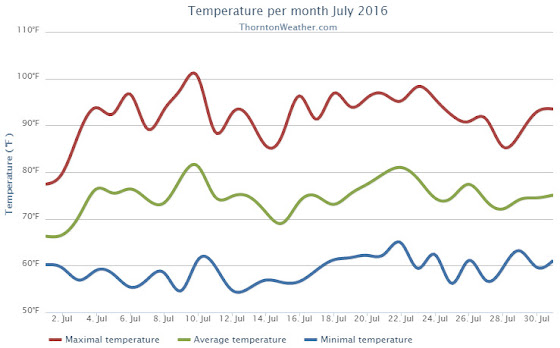
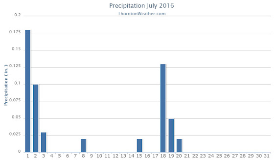
While the month of July seemed hot and dry, statistics show that only one of those two conditions held true.  We definitely saw a big time lack of precipitation but temperatures averaged out to near normal.

High pressure was the dominate feature for the month leading to overall dry conditions.  We started out cooler than normal and somewhat wet for the first two days of the month. That however changed quickly.

From the 3rd through the 17th of the month, Thornton saw temperatures largely remain above normal.  Only two days during that period saw precipitation and both were minimal amounts.  We saw our hottest temperature of the year to date and our only 100-degree temperature reading of the year on the 10th when the mercury topped out at 100.4 Degrees.

On the 14th and 15th of the month, we had a brief respite from the heat as temperatures were a bit below normal.  However, we then put together a string of 12 straight days of 90 degree or hotter readings.

The 28th and 29th then broke the streak with temperatures in the mid to upper 80s.  The month then closed with two days of above normal readings.

Thornton’s overall average temperature for the month came in at 74.7 degrees.  This is just above the long term Denver average for July of 74.2 degrees.  Out at DIA where the Mile High City’s official measurements are taken, the average for this July was much higher at 76.2 degrees.

Temperatures in Thornton ranged from the aforementioned 100.4 degrees on the 10th down to a low of 54.6 degrees on the morning of the 9th.  Denver’s official high for the month was 102 degrees on the 10th and its low of 51 degrees came on the 12th.

In terms of precipitation, Denver averages 2.16 inches during the July.  Thornton fell far short of that with a paltry 0.55 inches of rain in our bucket.  The airport, while receiving nearly double our total at 1.09 inches, was well short of average as well.

Click here to view Thornton’s July 2016 climate report.

Thornton, Colorado's July 2016 temperature summary. (ThorntonWeather.com)
Thornton, Colorado’s July 2016 temperature summary. (ThorntonWeather.com)
Thornton, Colorado's July 2016 precipitation summary. (ThorntonWeather.com)
Thornton, Colorado’s July 2016 precipitation summary. (ThorntonWeather.com)

From the National Weather Service:

CLIMATE REPORT
NATIONAL WEATHER SERVICE DENVER/BOULDER CO
235 AM MDT MON AUG 1 2016

................................... 

...THE DENVER CO CLIMATE SUMMARY FOR THE MONTH OF JULY 2016... 

CLIMATE NORMAL PERIOD 1981 TO 2010
CLIMATE RECORD PERIOD 1872 TO 2016

WEATHER         OBSERVED          NORMAL  DEPART  LAST YEAR`S
                 VALUE   DATE(S)  VALUE   FROM    VALUE  DATE(S)
                                          NORMAL
................................................................ 
TEMPERATURE (F)
RECORD
 HIGH             105   07/20/2005
 LOW               42   07/04/1903
                        07/31/1873
HIGHEST           102   07/10         M      -3       97  07/27
LOWEST             51   07/12         M       9       52  07/28
AVG. MAXIMUM     92.0              89.4     2.6     87.6
AVG. MINIMUM     60.5              58.9     1.6     57.9
MEAN             76.2              74.2     2.0     72.8
DAYS MAX >= 90     22              16.0     6.0       16
DAYS MAX <= 32      0               0.0     0.0        0
DAYS MIN <= 32      0               0.0     0.0        0
DAYS MIN <= 0       0               0.0     0.0        0

PRECIPITATION (INCHES)
RECORD
 MAXIMUM         6.41   1965
 MINIMUM         0.01   1901
TOTALS           1.07              2.16   -1.09     1.06
DAILY AVG.       0.03              0.07   -0.04     0.03
DAYS >= .01         6               8.3    -2.3       12
DAYS >= .10         4               4.3    -0.3        3
DAYS >= .50         1               1.4    -0.4        0
DAYS >= 1.00        0               0.7    -0.7        0
GREATEST
 24 HR. TOTAL    0.61   07/01 TO 07/01           07/18 TO 07/18
                        06/30 TO 07/01                    07/29 TO 07/29
                        07/01 TO 07/01                    07/29 TO 07/29
 STORM TOTAL       MM                                 MM
 (MM/DD(HH))            MM                    07/18(00) TO 07/18(00)
                                                 07/29(00) TO 07/29(00)9
                                                 07/29(00) TO 07/29(00)9

SNOWFALL (INCHES)
RECORDS
 TOTAL             MM   MM
TOTALS            0.0               0.0

DEGREE_DAYS
HEATING TOTAL       0                 6      -6        5
 SINCE 7/1          0                 6      -6        5
COOLING TOTAL     356               289      67      251
 SINCE 1/1        544               444     100      409

FREEZE DATES
RECORD
 EARLIEST     09/08/1962
 LATEST       06/08/2007
EARLIEST                        10/07
LATEST                          05/05
.......................................................... 

WIND (MPH)
AVERAGE WIND SPEED              10.2
RESULTANT WIND SPEED/DIRECTION   3/169
HIGHEST WIND SPEED/DIRECTION    54/340    DATE  07/24
HIGHEST GUST SPEED/DIRECTION    74/340    DATE  07/24

SKY COVER
POSSIBLE SUNSHINE (PERCENT)   MM
AVERAGE SKY COVER           0.50
NUMBER OF DAYS FAIR           10
NUMBER OF DAYS PC             19
NUMBER OF DAYS CLOUDY          2

AVERAGE RH (PERCENT)     46

WEATHER CONDITIONS. NUMBER OF DAYS WITH
THUNDERSTORM             12     MIXED PRECIP               0
HEAVY RAIN                1     RAIN                       0
LIGHT RAIN               13     FREEZING RAIN              0
LT FREEZING RAIN          0     HAIL                       0
HEAVY SNOW                0     SNOW                       0
LIGHT SNOW                0     SLEET                      0
FOG                       3     FOG W/VIS <= 1/4 MILE      0
HAZE                      1

-  INDICATES NEGATIVE NUMBERS.
R  INDICATES RECORD WAS SET OR TIED.
MM INDICATES DATA IS MISSING.
T  INDICATES TRACE AMOUNT.

July 31 to August 6: This Week in Denver Weather History

This Week In Denver Weather History
July 31 to August 6: This Week in Denver Weather History

How does 42 degrees sound right about now? That mark is one of the highlights of this week in Denver weather history. It was the low temperature recorded twice in our past and the coldest July temperature on record. Many more notable events have also occurred.

From the National Weather Service:

13-5

In 2008…a streak of 24 consecutive days of 90 degrees shattered the previous record of 18 consecutive days established in 1901 and 1874. Ironically…no new single day record high temperatures were set in the month of July. In August however…a record of 104 degrees was set on the 1st…and another record of 103 degrees was set on the 2nd. In addition…a record low min of 70 degrees was set on August 2nd.

18-2

In 1987…a streak of 16 consecutive days of 90 degrees ranked 4th on the list of hot streaks. The record of 24 consecutive days was established in the summer of 2008.

27-31

In 1956…96 percent of the total precipitation for the month of July occurred over the last five days of the month. Heavy thunderstorms produced 4.00 inches of rainfall at Stapleton Airport. This amount of precipitation in 5 days or less had been exceeded only 3 times in previous record. The last time had been in December of 1913 as snow. Considerable property damage occurred across metro Denver from flooding.

31

In 1873…the all-time lowest recorded temperature in July… 42 degrees…occurred. The same temperature also occurred on July 4…1903.

In 1874…during the late afternoon rain and hail fell for 5 minutes followed by brief heavy rain. Pieces of solid ice of irregular shape fell upon the roof of the station. The hail stones measured 1 1/2 inches in diameter. Precipitation (rain and melted hail) was only 0.16 inch.

In 1889…the high temperature climbed to 100 degrees in downtown Denver.

In 1919…heavy thunderstorm rainfall totaled 2.59 inches in downtown Denver during the evening. Rainfall was 1.90 inches in an hour…a new record at that time.

In 1961…over an inch of rain in a short period of time caused flooding of streets and basements in Denver. Rainfall totaled 1.30 inches at 11th and Lincoln in central Denver.

In 1964…the temperature reached 91 degrees in Denver…making this the 27th day of the month that the temperature reached 90 degrees or more. This is the all time record for 90 degree days in a month in Denver.

In 1972…one inch diameter hail fell in Hudson northeast of Denver.

In 1976…during the evening hours extremely heavy thunderstorm rains produced flash flooding in Big Thompson Canyon which killed 144 people between Estes Park and Loveland. No significant weather occurred in metro Denver at the time.

In 1987…1 inch diameter hail fell in Lakewood and 3/4 inch hail fell near Louisville. Southeast Boulder County was drenched with 1.25 inches of rain in just 20 minutes.

In 1993…thunderstorm winds damaged a chimney of a home near Parker.

In 1996…a weak tornado (f0) was sighted 12 miles east of Denver International Airport. No damage was reported.

In 1998…heavy monsoonal thunderstorm rain triggered a mud slide in Blackhawk. The mudslide blocked Main St. and caused an estimated half million dollars in damage to a casino. Heavy thunderstorm rain…up to 3 inches in an hour…caused a flash flood along Buffalo Creek. Portions of County Road 126 just south of the town of Buffalo Creek were washed out. The flood waters nearly washed away the bridge as mud and debris slammed into the structure. Hail to 1 3/4 inches in diameter fell near Idaho Springs.

In 2004…severe thunderstorm winds toppled a 65-foot blue spruce tree in Parker. The tree landed on a home damaging the roof and gutters. The downed tree poked dozens of holes into the shingles.

In 2013…severe thunderstorm winds… with gusts estimated to 80 mph…downed power poles which caused scattered outages in and around Byers…Bennett and Strasburg. Some property damage was also observed. Near Byers…aluminum siding and roofing was peeled off sheds. Large hail…up to one inch in diameter… was reported north of Bennett. At Denver International Airport…a peak wind gust to 40 mph was observed from the northeast.

1

In 1888…heavy rain in the mountains and foothills caused flooding on clear creek in Golden. The high waters also washed away portions of the railroad tracks in the canyon between Idaho Springs and Golden.

In 1901…the temperature reached a high of 100 degrees in the city.

In 1902…the high temperature climbed to 100 degrees in downtown Denver.

In 1914…a thunderstorm produced 1.00 inch of rainfall in just 21 minutes and north winds sustained at 43 mph with gusts to 50 mph. Rainfall totaled 1.17 inches.

In 1938…the temperature climbed to a high of 100 degrees in downtown Denver…which is the record maximum for the date. The temperature was also recorded on this date in previous years.

In 1976…flight operations at Stapleton International Airport were suspended for 90 minutes when the airport tower radar was knocked out and water reached a foot deep on some taxi ramps after 1.50 inches of rain fell in one hour. Heavy rain also caused minor flooding in east Denver and Aurora where lightning damaged the roof of a home and injured the owner. One young man was swept down a flooded ditch…but was rescued by firemen. A number of rafts were floated in flooded streets. Thunderstorm rainfall totaled 1.71 inches at Stapleton International Airport.

In 1978…a tornado damaged a house and broke a power pole 5 miles northwest of Parker. A microburst wind gust to 52 mph briefly reduced visibility to 1 mile in blowing dust at Stapleton International Airport.

In 1985…heavy thunderstorms roared through the southern and western sections of metro Denver…producing large hail and heavy rain. Lightning hit a recreational vehicle trailer causing it to burn. There was a lot of street flooding over western suburbs where rainfall totaled over 2 inches in some areas. One inch diameter hail was reported in Littleton and near Evergreen. Hail piled 4 to 6 inches deep at Tinytown in the foothills southwest of Denver.

In 1990…a small rope-like tornado was spotted in open country 15 miles southeast of centennial airport. No damage was reported from the twister.

In 1992…pilots reported a funnel cloud near the construction site of the new Denver International Airport. A few minutes later…a tornado was reported near Bennett. The tornado remained on the ground for about 18 minutes and was visible from the national weather service office at Stapleton International Airport. Thunderstorm wind gusts to 70 mph were reported near Bennett and Watkins with a wind gust to 60 mph at Brighton. Two men were injured when struck by lightning. A young man sustained serious injuries when struck by lightning while jet skiing on Cheery Creek Reservoir. A man received only minor injuries when struck by lightning while golfing in Westminster.

In 1994…heavy thunderstorm rains in the foothills west of Denver caused the closure of the Virginia Canyon Road north of Idaho Springs by rocks and debris.

In 2001…a 34 year old man on the South Platte River bike path in Denver received minor injuries when lightning struck a nearby tree. Lightning…coupled with strong thunderstorm winds…knocked out electrical power to about 10 thousand homes and businesses in Golden.

In 2006…strong thunderstorms hit southern metro Denver. A severe thunderstorm wind gust estimated to 71 mph knocked down a tree in Aurora near Cherry Creek. Lightning sparked a fire in a home near lone tree and struck a transformer at an RTD light rail station at Interstate 25 and Yosemite Street. Heavy thunderstorm rainfall forced the closure of Arapahoe Road between Holly and Quebec streets due to high water. Flooding was also reported near Park Meadows Mall and Greenwood Village. Heavy rainfall also caused flooding in Highlands Ranch…lone tree…and Parker. Water up to 6 inches deep was reportedly running over the roads.

2

In 1878…the high temperature reached 100 degrees in downtown Denver.

In 1911…an apparent dry microburst produced sustained west winds to 42 mph.

In 1972…one workman was killed and another injured when a strong gust of wind destroyed a partially completed apartment building in south Denver. Hail to 1 3/4 inch diameter fell in Golden.

In 1973…hail to 3/4 inch diameter was reported in Boulder.

In 1986…a major outbreak of severe thunderstorms occurred along the Front Range. Thunderstorms developed explosively. Some places were hit by large hail twice. Two inch diameter hail broke car windows on I-25 west of Brighton…and up to 1 1/4 inch hail broke windows in Thornton. Baseball size hail damaged several planes near Watkins. Funnel clouds were sighted around Aurora. Hail over 1/2 inch in diameter covered the ground 3 to 4 inches deep at Hudson northeast of Denver. Most of the hail fell north of metro Denver…but 3/4 inch diameter hail was measured at Stapleton International Airport. Total damage from the hail storms this day was estimated at over 10 million dollars.

In 1991…late afternoon thunderstorms produced heavy rain across metro Denver. Two feet of water covered parts of I-25 in southeast Denver…while one foot of water covered parts of U.S. Highway 285 in Englewood. Thunderstorm rainfall totaled 0.50 inch at Stapleton International Airport.

In 2001…severe thunderstorms producing heavy rain and hail… Either washed out or damaged several County roads in the Watkins and Bennett areas. A small tornado (f0) touched down near Bennett…but did no damage. Hail as large as 1 3/4 inches in diameter fell near Watkins. One inch diameter hail was measured near Hudson and Keenesburg.

In 2008…strong winds blew several trees down in Denver… Damaging homes and downing power lines. A peak wind gust of 67 mph occurred at Centennial airport…with gusts to 60 mph estimated in Denver. A peak wind gust of 37 mph was measured at Denver International Airport. An elderly man was killed when a wind damaged tree broke free and crushed him while he attempted to remove it. The downed power lines caused outages to about 500 Xcel Energy customers.

2-3

In 1876…grasshoppers were in great abundance in the city and caused considerable damage to gardens and to crops in the surrounding farms and ranches.

In 1951…heavy thunderstorms rumbled across metro Denver through the night. Heavy rain totaled 3.45 inches at Stapleton Airport. This was the greatest 24 hour precipitation ever recorded during the month of August in Denver.

In 2007…heavy rain caused localized flash flooding near Ft. Lupton. Up to 8 inches of water was reported across County road 18.

In addition…several other County roads in the immediate area were washed out.

Continue reading July 31 to August 6: This Week in Denver Weather History

July 2016 top shots: Monthly photo slideshow

The McNeil twins take in the fireworks on the 4th of July. (Jennifer McNeil)

Colorado offers outdoor opportunities unlike any other state and while the summer heat settles in, photos of the amazing scenes across our state provide a view into why we love it here so much.

The weather this time of year has a pretty standard pattern of quickly warming temperatures followed by afternoon thunderstorms that can cool things down.  These storms sometimes provide a good bit of ‘excitement’ and are a prime photo subject.

  • Slideshow updated July 25, 2016

Recreationalists head outdoors and take advantage of urban, suburban and rural opportunities.  As they do, our abundant wildlife that is found just about anywhere comes into focus.

Showcasing images captured by ThorntonWeather.com readers as well as some of our own, our monthly slideshow covers the entire gamut of weather and nature related imagery.   Sunsets, sunrises, wildlife and of course every type of weather condition are vividly depicted.

To learn more about how to send your photo to us for inclusion in the slideshow, see below the slideshow.

[flickr_set id=”72157670236285162″]

What is missing in the slideshow above?  Your photo!

Our monthly photo slideshow is going to feature images that we have taken but more importantly images that you have captured.  The photos can be of anything even remotely weather-related.

Landscapes, current conditions, wildlife, pets, kids.  Whimsical, newsy, artsy.  Taken at the zoo, some other area attraction, a local park, a national park or your backyard.  You name it, we want to see and share it!

Images can be taken in Thornton, Denver or anywhere across the extraordinary Centennial State.  We’ll even take some from out of state if we can tie it to Colorado somehow.

We’ll keep the criteria very open to interpretation with just about any image eligible to be shown in our slideshows.

What do you win for having your image in our slideshow?  We are just a ‘mom and pop’ outfit and make no money from our site so we really don’t have the means to provide prizes.  However you will have our undying gratitude and the satisfaction that your images are shared on the most popular website in Thornton.

To share you images with us and get them included in the slideshow just email them to us or share them with ThorntonWeather.com on any of the various social media outlets.  Links are provided below.

So come on, get those camera’s rolling!

July 24 to July 30: This week in Denver weather history

This Week In Denver Weather History
July 24 to July 30: This week in Denver weather history

As we near the end of July the weather in Denver tends to be a bit more stable. That doesn’t mean the severe weather threat disappears as can be seen at our look back at this week in Denver weather history. Particularly notable are lightning injuries and deaths, flash flood events and even tornadoes.

From the National Weather Service:

7-25

In 1934…a streak of 15 consecutive days of 90 degrees ranked 5th on the list of hot streaks. The record of 24 consecutive days was established in the summer of 2008.

13-5

In 2008…a streak of 24 consecutive days of 90 degrees shattered the previous record of 18 consecutive days established in 1901 and 1874. Ironically…no new single day record high temperatures were set in the month of July. In August however…a record of 104 degrees was set on the 1st…and another record of 103 degrees was set on the 2nd. In addition…a record low min of 70 degrees was set on August 2nd.

18-2

In 1987…a streak of 16 consecutive days of 90 degrees ranked 4th on the list of hot streaks. The record of 24 consecutive days was established in the summer of 2008.

20-25

In 1965…heavy showers and thunderstorms doused metro Denver with significant rain each day. Rainfall for the six days totaled 5.16 inches at Stapleton International Airport. Massive rainfall occurred on the 20th…21st…and 25th… Flooding streets and basements and causing streams to overflow. The heaviest rainfall…2.05 inches…at Stapleton International Airport occurred on the 25th.

24

In 1896…heavy cloudbursts in the foothills west of Denver caused flash flooding on Bear Creek…Clear Creek…Golden Gate Gulch…and Mount Vernon Creek…resulting in a total of 27 deaths. The downpour dislodged large Boulders…one of which crushed a house. The heavy rain also caused a dam on cub creek to wash out…adding even more water to the flood. A wall of water as high as 10 feet flooded Evergreen and passed down bear creek…washing away many structures along the way. The flood crest produced 3 feet of water in downtown Morrison during the early evening. Flash flooding on Mount Vernon Creek added to the flooding in Morrison. In Golden…the flooding washed out bridges on clear creek and on Cresman and Tucker gulches and forced the closure of the power plant. In Denver…a thunderstorm produced hail of unknown size during the afternoon and rainfall of 1.23 inches overnight.

In 1958…a thunderstorm wind gust to 52 mph was recorded at Stapleton Airport.

In 1965…heavy rain caused flooding on clear creek and tucker gulch in Golden and west Denver. Damage in Golden was estimated at 80 thousand dollars. Heavy rain south of Denver washed out temporary earthen bridges constructed following the June floods in Castle Rock…Littleton… Englewood…and Denver. Bear creek in south Denver reached flood stage. A cloudburst on cub creek in Evergreen washed out bridges and roads. Heavy rain fell over all the Denver and Aurora areas…causing some flooding of roads…streets… And bridges. A man drowned in a flooded irrigation canal near Hudson. Heavy rain caused flooding of streets and roads in Blackhawk and central city. Hail caused minor damage in Idaho Springs.

In 1967…seven bridges were washed out along a normally dry creek bed south of State Highway 7 west of Brighton. One car was washed into the creek when a bridge gave way.

In 1970…hail stones to 1 1/4 inches in diameter fell in the foothills of Jefferson County southwest of Denver.

In 1971…golf ball size hail was reported in foothill areas of Jefferson County west of Denver. A funnel cloud was sighted in Aurora. Wind gusts estimated at 60 mph…hail… And heavy rain up to an inch in 15 minutes caused local flooding and some other damage in several areas of metro Denver. Hailstones to 3/4 inch in diameter fell 7 miles southeast of Denver.

In 1973…a thunderstorm wind gust to 52 mph was recorded at Stapleton International Airport where one inch diameter hail was measured.

In 1981…strong winds downed a power line in northeast Denver. Wind gusts to 50 mph were recorded at Chatfield Reservoir.

In 1987…3/4 inch diameter hail fell 5 miles northeast of Commerce City.

In 1996…hail…up to 1 3/4 inches in diameter…fell at Chatfield Reservoir. Hail to 3/4 inch in diameter was measured near Bennett.

In 2000…lightning struck near two golfers at ute creek golf course near Longmont…knocking them to the ground. The men received only minor injuries.

In 2001…lightning from a thunderstorm knocked out electrical power to about 1500 residents in the city of Denver.

In 2004…a chilly day with fog and thunderstorms resulted in two temperature records. The low temperature of 49 degrees was a record minimum for the date. The high temperature of only 58 degrees was a record low maximum for the date.

24-25

In 2003…maximum temperature of 100 degrees on the 24th was a record high for the date. Low temperature of 73 degrees on the 25th was a record high minimum for the date.

25

In 1875…brief heavy rain and hail lasted only 5 minutes… But the 1/4 inch diameter hail covered the ground to a depth of 1/2 inch and made the streets look like there had been snowfall. There was much crop damage…especially to corn…and some sheep were killed. Precipitation totaled 0.51 inch in the city.

In 1896…a heavy thunderstorm produced sustained northwest winds to 45 mph with gusts to 50 mph and 1.02 inches of rain.

In 1965…a cloudburst dumped 1.99 inches of rain in 30 minutes at Stapleton International Airport. The storm was accompanied by strong winds gusting to 70 mph. The heavy rain flooded numerous streets in east Denver and Aurora. One inch diameter hail accompanied a cloudburst…9 miles southwest of Denver. A funnel cloud was sighted 25 miles northwest of Denver. In Aurora…there were unofficial reports of 2.30 inches of rain in 40 minutes and 3.30 inches of rain in 30 to 40 minutes. Rainfall totaled 2.05 inches at Stapleton International Airport. Rainfall of 2.42 inches for 24 hours on the 24th and 25th was the second greatest on record for July.

In 1977…a tornado touched down briefly in Aurora southeast of Cheery Creek Reservoir. No damage was reported. A funnel cloud was sighted for 4 minutes by national weather service personnel 10 miles north of Stapleton International Airport near Henderson.

In 1991…heavy rain…up to half an inch in 10 minutes…caused flooding in Westminster…Northglenn…and north Denver where a section of railroad track was washed away. At Stapleton International Airport…heavy thunderstorm rain totaled 1.85 inches and briefly reduced the visibility to 1/4 mile. Hail to 1/8 inch in diameter was also measured. A tornado touched down briefly near Fort Lupton. No damage was reported.

In 1998…heavy monsoonal thunderstorm rains caused flooding and flash flooding in eastern and southern sections of metro Denver…including Englewood and Aurora…when about 2 to 3 inches of rain inundated the area. Both I-25 and I-70 were closed for 2 to 3 hours as several low lying areas became impassable due to the high waters. The water was estimated to be 15 feet deep in one flooded underpass along I-25. As a result…the freeway was closed from south of 6th Avenue to University Blvd. Standing water forced the closure of I-70 at gun club road east of Denver. In Englewood…U.S. Highway 285 was closed…when high water made it impassable. Several cars were reportedly floating down the roadway near Sheridan Blvd. In Aurora…the intersection at Yale Ave. And chambers rd. Was flooded by high water up to 4 feet deep when a spillway on the high line canal was breached. Lightning also knocked out 11 transformers across metro Denver…causing several small fires and scattered power outages. Flood and flash flooding also occurred north of Strasburg when as much as 2.51 inches of rain fell in an hour. The deluge resulted in considerable flooding of local streets and County roads. Torrential rainfall of 2 to 3 inches in less than an hour triggered a flash flood in Virginia Canyon. County road 279 between Idaho Springs and Central City was closed for two days to clear debris from mudslides. Several cars in Idaho Springs were washed off the road…and numerous basements were flooded in town. Thunderstorm rainfall totaled 2.69 inches at Denver International Airport.

In 2001…lightning struck two homes in Lafayette…damaging the roof and attic of one and shorting out the electrical system in another. Hail to 1 3/4 inch in diameter was measured 7 miles north of Castle Rock with 3/4 inch hail 7 miles north of Sedalia.

In 2005…heavy thunderstorm rain in the vicinity of the overland wildfire burn scar triggered a mudslide in Jamestown. Rocks the size of bowling balls…along with silt and mud slid down the mountain into the town. No one was injured. One parked car was buried by the debris.

In 2006…heavy thunderstorm rainfall caused flash flooding 1 mile north of the town of Westcreek in southwestern Douglas County. Several maintenance roads were washed out by the floodwaters.

26

In 1891…a thunderstorm produced sustained northeast winds to 44 mph with gusts to 60 mph and 0.16 inch of rain.

In 1894…a thunderstorm produced sustained southwest winds to 36 mph with gusts to 58 mph…but only 0.04 inch of rain.

In 1910…the high temperature reached 100 degrees in downtown Denver.

In 1959…a Denver man was stunned while standing by a car that was struck by lightning. He was treated for burns and shock at a local hospital. Thunderstorm winds gusted to 55 mph at Stapleton Airport.

In 1983…two heavy thunderstorms hit the northern and western suburbs. The first drenched Northglenn with an inch of rain in 30 minutes. The second storm dumped an inch or more of rain in Idaho Springs and Evergreen. The heaviest rainfall… 2.90 inches in an hour…caused minor street flooding in Golden.

In 1984…heavy early morning thunderstorms drenched the foothills southwest of Denver. Rainfall to 1 1/2 inches in just 30 minutes occurred between Evergreen and Conifer. In nearby Turkey Creek Canyon…1.80 inches of rain was recorded in 35 minutes.

In 1985…a long rope-like white tornado touched down 5 miles east of Erie and stayed on the ground…mainly over an open field…for 18 minutes. However…the twister damaged a few cars on I-25 and injured 3 people from broken glass. The storm flipped over a van…blew out car windows…and ripped a highway sign. It also blew an outbuilding off its foundation. A tornado also touched down briefly 8 miles north of Bennett. No damage was reported from this storm.

In 1988…a 9-year-old girl was slightly injured by lightning in Parker.

In 2003…a severe thunderstorm in and south of Franktown produced hail as large as 1.75 inches in diameter.

Continue reading July 24 to July 30: This week in Denver weather history

July 17 to July 23: This Week in Denver Weather History

This Week In Denver Weather History
July 17 to July 23: This Week in Denver Weather History

Our weekly look back at Denver weather history always has interesting items but this week one stands out in particular. Denver has never officially recorded snow during the month of July. However, before official records began in 1882, the U.S. Army Signal Service weather observer reported snow on July 17, 1872!

From the National Weather Service:

7-25

In 1934…a streak of 15 consecutive days of 90 degrees ranked 5th on the list of hot streaks. The record of 24 consecutive days was established in the summer of 2008.

13-5

In 2008…a streak of 24 consecutive days of 90 degrees shattered the previous record of 18 consecutive days established in 1901 and 1874. Ironically…no new single day record high temperatures were set in the month of July. In August however…a record of 104 degrees was set on the 1st…and another record of 103 degrees was set on the 2nd. In addition…a record low min of 70 degrees was set on August 2nd.

16-18

In 1997…an extended hot spell resulted in 3 temperature records being set. The maximum temperature reached 98 degrees on each of the days…setting records on the 16th and 18th. The low temperature of 71 degrees on the 17th was a record high minimum for the date. The high temperature reached 100 degrees on the 17th at the site of the former Stapleton International Airport.

17

In 1872…the U.S. Army Signal Service weather observer recorded snowfall during the early morning hours in the hand written daily weather journal: “rain commenced at 1:30 a.m. changing about 3 a.m. to snow & in about half an hour to rain again; it continued until 6 a.m.” this is the only recorded occurrence of snowfall in Denver in July…but this report is not included in the “official” station snowfall records…which did not begin in Denver until January 1…1882. The low temperature on this morning was 45 degrees…which is sufficiently cold for the occurrence of light stratiform snowfall.

In 1918…a thunderstorm produced hail to an inch in depth on the ground. The stones varied in size from a small cherry stone to nearly 1/2 inch in diameter. Not much permanent damage was done to crops. Precipitation totaled 0.40 inch…and northeast winds were sustained to 25 mph with gusts to 28 mph.

In 1971…the temperature reached a high of 101 degrees at Stapleton International Airport.

In 1983…3/4 inch diameter hail fell at Lafayette…while golf ball size hail pelted Brighton and Northglenn where funnel clouds were also sighted.

In 1986…1 1/2 inches of rain fell in an hour and 15 minutes in southeastern Aurora. Thunderstorm rainfall totaled 0.89 inches at Stapleton International Airport.

In 1987…a small tornado was sighted near Watkins…in the vicinity of Front Range airport.

In 1997…lightning ignited an oil well tank holding 10 thousand gallons of oil…16 miles northwest of Bennett. About 200 acres of grassland burned before the fire could be extinguished. A dry microburst produced a wind gust to 52 mph at Denver International Airport.

In 2000…an estimated 2 inches of rain fell in less than an hour…causing two secondary roads in buck and miller gulches in the hi meadows fire burn area to wash out. Water also covered Jefferson County road 68 which connects to Bailey. Homeowners in pine valley estates attempted to divert some of the runoff by piling stacks of hay on the hillside above their homes. Torrential rainfall…up to 3.50 inches an hour…caused flash flooding along Whiskey Gulch near Elizabeth. Several roads were washed out and basements flooded during the storm. Along County Road 13… About 6 miles north-northwest of Elizabeth…rushing water washed away a 15-foot section of the road. The floodwaters forced debris and mud into four huge culverts…sending water over the road. At Denver International Airport…an United Airlines ground crew worker was struck by lightning as she was loading a Boeing 747 jumbo jet. The woman was injured when lightning either hit the jet or the loading equipment that she was working near. The 25-year-old woman received only minor injuries.

In 2006…outflow from severe thunderstorms to the southeast of metro Denver produced southeast sustained winds to 35 mph with gusts as high as 52 mph at Denver International Airport during the late evening.

In 2011…a deluge of heavy rain occurred in and around Nederland when the storm dumped nearly 2 inches of rain in 30 minutes. The heavy rainfall washed out hillsides and dirt roads. In Nederland…a culvert became blocked with debris and forced the water to spread into a nearby bookstore. The rainfall also damaged several residential roads in the Sunnyside Subdivision and Navajo Road became impassable. Several homes suffered flood damage as the runoff from a nearby Beaver Creek jumped its banks and flooded garages…living rooms and bedrooms of nearby houses.

18

In 1874…the temperature climbed to 90 degrees or more for the 18th consecutive day…setting a record. The record was equaled from July 6th through the 23rd in 1901.

In 1902…a thunderstorm produced northwest winds sustained to 45 mph with gusts to 48 mph along with rain and hail. Total precipitation was 0.53 inch.

In 1911…a shower produced north winds sustained to 44 mph.

In 1958…1 1/2 inch diameter hail fell 9 miles west-southwest of Stapleton Airport.

In 1981…a thunderstorm bombed Evergreen with about 2 inches of rain in 45 minutes. A heavy hailstorm left 5 to 7 inches of hail on the ground in some places and stopped the Colorado Open golf tournament at Hiwan.

In 1985…over 2 inches of rain doused the southwest suburbs of Denver. Street flooding occurred in the Montbello area of northeast Denver.

In 1992…nickel size hail fell across central Douglas County near Castle Rock and Sedalia. One inch diameter hail fell in Castle Rock.

In 1993…thunderstorm winds gusted to 60 mph at Strasburg east of Denver.

In 2004…heavy thunderstorm rainfall caused flooding over parts of the Virginia Canyon Road near Idaho Springs. Several sections of the roadway were washed out. The road was closed temporarily for repairs.

18-19

In 2003…heavy rain producing thunderstorms caused flash flooding across southern metro Denver. Automated rain gages measured 2 to 3 inches of rain in less than an hour. The heavy rainfall caused many intersections and underpasses to flood…stranding motorists. Sections of I-25 and I-225 were closed due to the high water.
18-2

In 1987…a streak of 16 consecutive days of 90 degrees ranked 4th on the list of hot streaks. The record of 24 consecutive days was established in the summer of 2008.

19

In 1875…recent heavy rains produced high waters on many creeks and rivers in the area…which threatened the destruction of property at some locations. Cherry Creek in the city was running the highest in 10 years. Heavy rain in the mining regions over the last 2 days resulted in water running “everywhere” and the suspension of some work.

In 1881…a thunderstorm passing across the city produced lightning with no rain. A woman was seriously injured when struck by lightning several blocks from the weather office in downtown Denver.

In 1934…the temperature reached a high of 100 degrees in downtown Denver.

In 1965…hail…rain…and lightning hit west metro Denver. Hail stones as large as 1 1/2 inches in diameter accumulated to a depth of 2 inches in Evergreen where 2.95 inches of rain in 2 hours caused some flooding in the business section of the town. Lightning caused some power outages.

In 1973…two funnel clouds were observed 5 miles southeast of Littleton. The same funnel clouds were observed for 20 minutes…5 miles west and 5 miles west-southwest of Arapahoe County airport…now centennial airport.

In 1975…lightning injured a man in Denver and caused power outages in Aurora…Lakewood…Westminster…and west Denver.

In 1984…strong thunderstorm winds gusting to 45 mph shattered 7 large plate glass windows at Stapleton International Airport.

In 1985…a tornado touched down in the surrey ridge area of northern Douglas County…just west of I-25. Ten homes were damaged; one under construction was nearly destroyed. Two vehicles were thrown off I-25 injuring three people. A pick-up truck was thrown 50 feet by the twister. In addition…a cluster of severe thunderstorms pounded all of metro Denver with torrential rain…hail…and wind. The heaviest rain fell in Aurora where one location reported 2.37 inches in just 40 minutes. One location in northeast Aurora received a total of 4.30 inches from the storm. There was extensive street and basement flooding…and a number of roads were damaged or washed out. An Aurora boy suffered minor injuries when he was washed into a drainage ditch. Golf ball size hail in Aurora piled up to 5 inches deep. An inch of rain fell in 20 minutes at Stapleton International Airport…closing it to air traffic for an hour. Up to 1 1/2 inches of rain fell in just 15 minutes over central Denver with the high water closing I-25. The water was so deep on the freeway…that one vehicle was completely submerged and people were diving into the water from the freeway overpass. Three homes in Littleton were damaged by lightning. Wind blew out several windows from a high rise apartment building in southeast Denver. Rainfall totaled 1.51 inches at Stapleton International Airport.

In 1997…torrential rain and damaging hail pummeled eastern sections of metro Denver. Hail up to 1.25 inches in diameter fell at the national weather service office on the site of the former Stapleton International Airport. The hail continued for about 15 minutes and accumulated to a depth of 2 to 3 inches…causing extensive damage to cars in the area. Heavy rainfall totaled 3.83 inches in about an hour from the nearly stationary thunderstorm. Numerous cars stalled along I-70…and several homes were flooded in east Denver. The roof of a building collapsed under the weight of the water. The next day several “fatalities” were discovered near the national weather service office; two prairie dogs were found dead along with three rabbits that either drowned or were killed by the large hail.

In 1999…lightning struck two residences in Littleton…but caused only minor damage. Lightning triggered a fire at a residence in cherry hills village. A small portion of the roof and ceiling were damaged before the fire could be extinguished.

In 2000…hail as large as 1.25 inches in diameter fell near roggen northeast of Denver.

In 2004…heavy rainfall caused flooding on the Virginia Canyon Road near Idaho Springs…which had to be closed for repairs.

In 2006…the temperature climbed to a high of 100 degrees. The high temperature was not a record maximum for the date.

In 2007…a severe thunderstorm produced large hail…up to 1 inch in diameter…about 6 miles north of Northglenn.

19-23

In 2005…the high temperature climbed above 100 degrees on each of the 5 days with readings of 101 on the 19th…105 on the 20th…104 on the 21st…and 102 on both the 22nd and 23rd. A new record maximum temperature for the month of July of 105 degrees was set on the 20th…which also equaled the all time record maximum for Denver of 105 degrees first set on August 8th in 1878. Daily maximum temperature records were set on each day…and the 5 day period equaled the record for the most consecutive days of 100 degrees or more first set from July 4th through 8th in 1989. The intense heat resulted in a high use of electricity for cooling purposes. The demand for electric power exceeded the supply and rolling black-outs… Each lasting about an hour…were scheduled across metro Denver during the afternoons and early evenings.

Continue reading July 17 to July 23: This Week in Denver Weather History