Tag Archives: June Weather

June 2020 top shots: Monthly photo slideshow

A pelican takes off at Barr Lake State Park at sunrise. (Bill Hutchinson)

The month of June typically sees springtime severe weather reach its height of activity in northeastern Colorado.

This affords the opportunity to capture extraordinary images of amazing weather phenomena from monstrous supercell thunderstorms to heavy rain, hail and even tornadoes.

  • Slideshow updated June 24, 2020

Showcasing images captured by ThorntonWeather.com readers as well as some of our own, our monthly slideshow covers the entire gamut of weather and nature related imagery.

Sunsets, sunrises, wildlife and of course every type of weather condition are vividly depicted.  June brings some very dynamic weather and the photos are a great way to see the stunning variety.

To learn more about how to send your photo to us for inclusion in the slideshow, see below the slideshow.

[flickr_set id=”72157714622707933″]

What is missing in the slideshow above?  Your photo!

Our monthly photo slideshow is going to feature images that we have taken but more importantly images that you have captured.  The photos can be of anything even remotely weather-related.

Landscapes, current conditions, wildlife, pets, kids.  Whimsical, newsy, artsy.  Taken at the zoo, some other area attraction, a local park, a national park or your backyard.  You name it, we want to see and share it!

Images can be taken in Thornton, Denver or anywhere across the extraordinary Centennial State.  We’ll even take some from out of state if we can tie it to Colorado somehow.

We’ll keep the criteria very open to interpretation with just about any image eligible to be shown in our slideshows.

What do you win for having your image in our slideshow?  We are just a ‘mom and pop’ outfit and make no money from our site so we really don’t have the means to provide prizes.  However you will have our undying gratitude and the satisfaction that your images are shared on the most popular website in Thornton.

To share you images with us and get them included in the slideshow just email them to us or share them with ThorntonWeather.com on any of the various social media outlets.  Links are provided below.

So come on, get those camera’s rolling!

June 21 to June 27: This week in Denver weather history

This Week in Denver Weather History

A typical week during the spring and summer for Denver – tornadoes, hail, damaging winds and more.

1-30

In 2012…it was the hottest June in Denver since weather records began back in 1872. The average temperature for the month was 75.0 degrees which was 7.6 degrees above normal. There were a total of seventeen 90 degree days in the month of June. The highlight of record setting month was a stretch of five consecutive 100 degree days from the 22nd to the 26th. This was only the third time in Denver weather history in which this happened. Two of the high temperatures during the stretch peaked at 105 degrees… Which set the all-time record for the month of June and tied the all-time maximum temperature for Denver.

19-21

In 1875…smoke from several large forest fires in the mountains was visible from the city on each of these days.

20-21

In 1897…high winds raked the city overnight. Southeast winds were sustained to 60 mph with gusts as high as 72 mph on the 20th. Southeast winds were sustained to 57 mph with gusts to 60 mph on the 21st.
In 2007…a brief hot spell produced two temperature records. The high temperature of 97 degrees was tied on the 20th. A new record high temperature of 99 degrees was established on the 21st.

21

In 1927…north winds were sustained to 40 mph with gusts to 44 mph.

In 1984…lightning struck and killed two children standing near a tree in a backyard in Lakewood. Strong thunderstorm downbursts caused a wind gust to 58 mph in Northglenn and knocked down two power poles near Brighton.

In 1988…lightning struck a home in Denver…causing about ten thousand dollars damage. Lightning damaged 3 homes in Littleton…and also hit a house in greenwood village that had been struck by lightning 7 years previously.

In 1991…thunderstorms produced widespread hail across metro Denver. Hail as large as 2 1/2 inches fell at several locations across southwest metro Denver. One storm spotter reported hail 8 inches deep near the intersection of I-25 and C-470. Heavy rain with the storms caused some street flooding. In Commerce City…several cars were under water… And in Westminster a police officer reported water up to the doors of his car. Damage to homes and automobiles totaled 55 million dollars.

In 1992…a tornado touched down briefly near Bennett. Another tornado was briefly on the ground near Strasburg.

In 1994…heavy thunderstorm rains caused flooding in metro Denver. Several vehicles were stalled in the high water on I-25. Lightning struck an underground natural gas line in Aurora…causing a fire. Widespread power outages were also observed.

In 1996…three homes were struck by lightning in Parker. The lightning struck the garage of the first home…which started a small fire that burned some siding and spread into the attic. A second home sustained damage to the attic when a small fire was started. The third home received only minor damage. Lightning also sparked two small grass fires in the area. A man in Lakewood received minor injuries when he was struck by lightning while working on a ladder. A funnel cloud was sighted in Castle Rock. Strong thunderstorm winds downed a large tree near crossroads mall in Boulder. A small tornado (f0) briefly touched down near Lafayette. No damage was reported.

In 1997…one inch diameter hail was measured in Boulder.

In 2002…a thunderstorm wind gust to 62 mph was recorded at Denver International Airport.

In 2005…severe thunderstorms produced hail to 1 inch in diameter in Broomfield along with 3/4 inch hail near Arvada.

In 2006…a man riding a motorcycle was struck and killed by lightning on U.S. Highway 36 between church ranch Blvd. And Sheridan Blvd. In Westminster. After the biker was struck…he and his motorcycle crashed into the center concrete median of the highway. The lightning bolt left a crater in the highway asphalt that measured 18 inches long…8 inches wide and 4 inches deep.

2010…A severe thunderstorm produced hail up to 1 1/2 inches in diameter near Morrison. In Lafayette and Louisville, hail up to one inch in diameter was observed.

2014…Three small tornadoes touched down in eastern Adams County near Barr Lake, Bennett and Front Range Aiport. The tornado near Barr Lake damaged some out buildings and a storage shed. Minor roof damage to houses in the immediate area was reported near 168th Ave and Haymont Rd near 168th Ave and Haymont Rd. It was rated an EF1. The others did no damage.

21-22

In 1941…strong thunderstorms produced cloudbursts of rain in Boulder County…starting during the late evening of the 21st and continuing overnight. The heavy rains over the Boulder creek…left hand creek…and south St Vrain River basins produced flooding in already swollen streams and turned dry gulches into raging torrents. The force of the floodwaters swept a man from the arms of his wife to his death…severely damaged canyon homes and swept others away… And hurtled a car down a steep embankment after the driver narrowly escaped. West of Boulder…the Boulder canyon highway was littered with rocks and debris and collapsed when two culverts were washed away. The flood waters washed much debris down four mile canyon…damaging the road near the creek bed. A bridge over dry creek just south of Niwot was completely washed away.

In 1964…scattered hail and rain caused property damage and local flooding in Boulder.

In 1989…an unseasonably cold weather system produced strong winds over much of metro Denver and snowfall in the foothills as low as 7500 feet elevation. One to 6 inches of snow fell in the foothills west of Denver with 15 inches reported on the summit of Mount Evans. Six inches of snow were measured at Conifer. Rainfall totaled only 0.09 inch at Stapleton International Airport where northwest winds gusted to 29 mph on the 21st.

21-3

In 2002…the maximum temperature in Denver equaled or exceeded 90 degrees for 13 consecutive days…equaling the 5th longest such streak on record. The record of 18 consecutive days was set during the summer of 1901.

22

In 1872…small sandstorms…frequently seen on the prairie… Occasionally passed through the city.

In 1983…3/4 inch hail was observed at Deckers…and a thunderstorm produced wind gusts to 55 mph at Littleton.

In 1988…a tornado was spotted one mile east of Brighton; it remained on the ground for about 6 minutes…but did no reportable damage. Lightning damaged a home near Castle Rock.

In 1991…thunderstorms produced golf ball size hail in Lafayette. The strongest storms occurred north of metro Denver.

In 1992…nickel size hail was reported just east of Parker.

In 1995…large hail 3/4 to 1 3/4 inches in diameter fell in Castle Rock where a funnel cloud was sighted. Hail 3/4 inch to 1 inch in diameter fell in south Denver and Aurora. A funnel cloud was also sighted over Chatfield Reservoir. In Bennett…very strong dry microburst winds of unknown speeds ripped a 14- by 48-foot metal roof off of a barn. The roof was tossed approximately 250 yards. A few 150- pound railroad ties were moved 10 to 15 feet.

In 1997…a tornado touched down near the Adams County fairgrounds northeast of Denver…uprooting several trees and damaging a car. A dry microburst produced a brief wind gust to 69 mph at Jefferson County airport. A small brief tornado was sighted near Hudson…but did no reported damage.

In 1998…3/4 inch hail fell near Hudson.

In 1999…thunderstorm winds gusted to 63 mph at Denver International Airport.

In 2003…hail as large as 2 inches in diameter was measured in Fort Lupton with 3/4 inch hail in Erie and near Boulder.

In 2006…a small tornado (f0) touched down near Franktown… But caused no damage.

In 2008…strong winds from dry microbursts developed over parts of southern Weld and western Arapahoe counties. A peak gust of 60 mph was observed in centennial. Near Frederick…strong winds snapped 3 power poles and sparked a small grassfire near State Highway 52 and interstate 25. At Denver International Airport…a peak gust of 31 mph was observed.

22-26

2012…The maximum temperature exceeded 100 degrees for five consecutive days. Two of the high temperatures on the 25th and 26th peaked at 105 degrees, which set the all time record for the month of June and tied the all time maximum temperature for Denver.

Continue reading June 21 to June 27: This week in Denver weather history

June 14 to June 20: This week in Denver weather history

This Week in Denver Weather History

With severe weather season in full swing/, we see a very eventful week in Denver weather history. Wildfires, amazing hail storms, tornadoes, floods and more all make an appearance on the historical calendar.

1-30

In 2012…it was the hottest June in Denver since weather records began back in 1872. The average temperature for the month was 75.0 degrees which was 7.6 degrees above normal. There were a total of seventeen 90 degree days in the month of June. The highlight of record setting month was a stretch of five consecutive 100 degree days from the 22nd to the 26th. This was only the third time in Denver weather history in which this happened. Two of the high temperatures during the stretch peaked at 105 degrees… Which set the all-time record for the month of June and tied the all-time maximum temperature for Denver.

11-14

In 1999…damage from several hailstorms in and near metro Denver totaled 35 million dollars. About 17.5 million dollars was from automobile claims with another 17.5 million in homeowner claims. The areas hardest hit by the storms included Castle Rock…Commerce City…evergreen… And Golden.

12-17

In 2000…two large wildfires developed in the Front Range foothills as careless campers and very dry conditions proved to be a dangerous combination. Strong winds gusting in excess of 60 mph on the 13th fanned the flames… Spreading both wildfires out of control. Winds gusted to 78 mph atop Niwot Ridge near the continental divide west of Boulder. The Hi Meadows Wildfire…about 35 miles southwest of Denver…consumed nearly 11 thousand acres and 80 structures…mostly high priced homes. The Bobcat Wildfire…located about 12 miles southwest of Fort Collins… Consumed nearly 11 thousand acres and 22 structures. Late on the 16th…a strong cold front moved south over the great plains into northeastern Colorado. Low level upslope conditions developed in the wake of the front…producing 2 to 4 inches of snowfall overnight at elevations above 8 thousand feet. Firefighters were able to contain both fires shortly thereafter.

13-14

In 2006…the high temperature of 99 degrees on the 13th equaled the record maximum temperature for the date first set in 1994. The high temperature of 102 degrees on the 14th was a new record maximum temperature for the date.

14

In 1877…an evening thunderstorm produced lightning which struck several houses and killed a cow in the bottom land of the South Platte River

In 1886…hail as large as 3/4 inch in diameter fell in the city. Precipitation was only 0.10 inch.

In 1887…south winds were sustained to 41 mph.

In 1900…a thunderstorm produced northwest winds to 51 mph with gusts to 61 mph…but only a trace of rain.

In 1923…a severe thunderstorm pelted the city with hail. The stones ranged in diameter from 0.2 to 0.8 inch. Gardens and greenhouses suffered considerable damage. Rainfall was only 0.14 inch downtown.

In 1960…one workman was killed and 4 others injured in Lakewood when a partly built apartment building collapsed in strong winds. Microburst wind gusts to 54 mph caused some blowing dust at Stapleton Airport.

In 1967…tornadoes touched down briefly 3 miles west of Franktown and 4 miles northeast of Parker. No damage was reported. Numerous funnel clouds were reported over south metro Denver…one 5 miles south of Denver…one 2 to 3 miles north of Castle Rock…and two near Littleton.

In 1968…a microburst wind gust to 52 mph was recorded at Stapleton International Airport.

In 1972…1 3/4 inch hail was reported in Wheat Ridge.

In 1976…high winds…unusually strong for this late in the season…raked metro Denver. Wind gusts estimated to 100 mph tore 24 boats from their moorings and damaged a total of 47 boats at Boulder reservoir. Wind gusts to 82 mph were recorded in Boulder. The strong winds toppled the wind mast at a radio station in Boulder. An automobile was smashed by a fallen tree in Boulder. Other damage in Boulder was minor…but power outages occurred when tree limbs fell on power lines. At Jefferson County Airport near Broomfield…wind gusts to 78 mph were recorded with 87 mph gusts clocked at rocky flats nuclear plant south of Boulder. Wind gusts to 66 mph were observed in Littleton… And northwest winds gusted to 46 mph at Stapleton International Airport. The strong winds collapsed a barn near Arvada. Several horses received minor injuries. Thirty trees were uprooted or broken in Denver. Four major power outages occurred from west Denver and Lakewood to the foothills.

In 1982…the worst hailstorm in 17 years struck Commerce City. The storm left 4 to 8 inches of hail on the ground. A few of the stones were as large as golf balls. Many vehicles were dented…and some windshields were shattered. Roofs of homes were damaged. Total damage was estimated at over one million dollars. Hail to 1 inch in diameter also fell in Littleton. Only 1/4 inch hail was measured at Stapleton International Airport.

In 1988…lightning ripped a small hole in the roof of a home in the southern part of Boulder. There were some power outages in the area.

In 1992…an off duty national weather service employee reported hail to 1 inch diameter in Westminster.

In 1997…one inch diameter hail fell in Bennett…and 3/4 inch hail was measured in Littleton.

In 1999…hail as large as 1 1/2 inches in diameter hit Aurora. Lightning sparked two small fires at separate residences near the hiwan country club in evergreen.

In 2004…lightning sparked two small fires near Jamestown. One was in geer canyon and the other 7.5 miles up sunshine canyon. Both were quickly contained and caused no damage to structures in the area.

In 2009…a complex of severe thunderstorm produced large hail damaging thunderstorm and funnel clouds across parts of the Urban Corridor. The line formed along a boundary over the western suburbs of Denver then moved east. The boundary produced at least one well defined funnel cloud that could be observed by stadium full of baseball fans at Coors Field. Large hail…up to 1 3/4 inches in diameter…was reported in Arvada…Broomfield…Denver…Federal Heights and Northglenn. In addition…the storm produced peak wind gusts from 60 to 74 mph. At Denver International Airport…a peak wind gust to 58 mph was observed from the west-northwest.

In 2014…severe thunderstorms broke out across the urban corridor. Large hail…ranging in size from 1 to 2 inches in diameter…was observed. The area extended from around Englewood to Aurora and included: Brookridge…Cherry Knolls… Greenwood Village and south Denver. As many as 212 thousand residences were potentially impacted by the storms. The hail shattered windshields and damaged vehicles.

15

In 1907…south winds were sustained to 40 mph. The winds were strong all day.

In 1908…the hail storm was unusually severe. Heavy clouds moved over the city from the north and northwest…and by late morning the weather had become very threatening. Heavy rain with intermittent hail from pea to 3/4 inch in diameter fell near noon. The fall of rain and hail totaled 0.68 inch of precipitation with 0.35 inch in just 5 minutes. The temperature fell from 71 degrees to 51 degrees during the storm. The hail did considerable damage to trees…gardens…and hot houses. On sidewalks with northern exposures…the hail ranged in depth from 2 to 6 inches. West winds were sustained to 29 mph during the storm.

In 1956…strong southeast winds raked metro Denver all day. Sustained winds at 44 mph with gusts as high as 61 mph were recorded at Stapleton Airport where blowing dust briefly reduced the visibility to 2 miles.

In 1984…golf ball size hail pelted southern and central Aurora. Rainfall of 2.06 inches over central Aurora in just over an hour produced local street flooding.

In 1987…golf ball size hail fell in the southern part of Lakewood.

In 1988…several tornadoes developed across metro Denver. One tornado touched down just northeast of the rocky mountain arsenal. The twister moved very slowly and did no damage…except to demolish a small electrical substation… Even though it was on the ground for nearly 30 minutes. Later…another tornado was sighted east of Brighton about 2 miles north of Barr Lake. An F2 tornado cut a swath through northeast Denver. The main path went through a thickly wooded area for about 6 blocks and uprooted about 500 city owned trees…many of them large elms 75 to 100 years old. Hundreds of privately owned trees were also sucked from the ground by the slow moving twister…which was filmed by a news team in a helicopter as it uprooted trees. The replacement cost to the city owned trees was estimated at 1.5 million dollars. The twister did little damage to buildings. Some homes suffered roof and chimney damage…a gas main was ruptured…and some cars were damaged by falling trees. The uprooted trees also caused curb and sidewalk damage and cut some electrical wires. The funnel cloud passed close to Stapleton International Airport. Aircraft operations were shut down…and the tower was evacuated. The tornado was on the ground for almost 25 minutes. An F3 tornado cut an erratic path through south Denver for about 25 minutes…causing extensive damage in at least 3 areas. The twister damaged about 85 buildings… 20 severely; the total loss was estimated at 5 to 10 million dollars. Many cars were severely damaged; at least 15 vehicles were overturned. One trailer was lifted onto the top of a building that had just been unroofed; numerous antique cars inside the building were damaged. A ford bronco was blown over a church…and landed 100 yards away. A metal storage shed was deposited far above the ground in some power lines. The tornado uprooted many trees on a golf course. No one was seriously hurt…although seven people suffered minor injuries from flying debris. A golfer was thrown 40 feet…but was not hurt; a man clinging to a telephone pole was unscathed…but lost both shoes…a sock…and buttons off his shirt. A woman holding a baby was sucked through a broken convenience store window… But was unhurt. A dog…tethered to the ground by its leash…was suspended in the air by the twister. Uprooted trees crushed cars and damaged curbs and sidewalks. People in downtown Denver could see three tornadoes occurring simultaneously. Hail as large as 1 3/8 inches in diameter fell in extreme southeast Aurora.

In 1997…a tornado touched down briefly at the Colorado national speedway near Dacono north of Denver. The tornado ripped through the south grandstand causing at least 50 thousand dollars in damage to a shed…kiosk… Bleachers…and several concession stands.

In 2004…a tornado touched down briefly near Castle Rock and blew the roof off a machine shop. A tornado near Elizabeth destroyed a barn and caused roof damage to a home. Two other barns on nearby properties were damaged extensively. The twister also caused widespread tree damage in the area. A tornado also touched down near Bennett and Strasburg…but did no damage.

In 2009…thunderstorm winds knocked a tree on to two vehicles in Boulder. One of the drivers was injured when the tree smashed into the windshield of her car.

In 2012…a severe thunderstorm produced hail from quarter to half dollar size near Littleton and Highlands Ranch. A weak short lived tornado (ef0) also touched down near Bennett.

15-16

In 1963…heavy rain and hail ravaged metro Denver. In southeast Denver…heavy rain flooded homes and streets. Hail to a depth of 4 inches on the ground stripped trees and plants and drifted to depths of 3 to 4 feet in some areas. Flood waters on the valley highway were 19 feet deep in places…trapping many cars. Many creeks were running over their banks. On the 15th…the main thunderstorm cell passed over south Denver…dumping as much as 4 inches of rain in 90 minutes. Precipitation at Stapleton Airport totaled 0.91 inch on the 15th and 1.31 inches on the 16th. A funnel cloud was sighted briefly 4 miles to the south-southeast of Stapleton Airport on the 15th. Damage from hail and flooding amounted to near a million dollars.

16

In 1950…very heavy rain and hail storms in southwest Denver caused an estimated 750 thousand dollars in hail and flood damage. Thunderstorms produced 2.06 inches of rain at Stapleton Airport with 2.23 inches of rain measured in downtown Denver.

In 1965…a tornado…15 miles south-southeast of Denver… Touched down and damaged two houses in northern Douglas County. Three golfers at a country club and a woman who lived north of Castle Rock were injured by falling structures.

In 1983…a microburst wind gust to 54 mph was recorded at Stapleton International Airport.

In 1984…a tornado touched down briefly in Parker. No damage was reported.

In 1986…lightning injured 5 people just north of the Denver city limits in Adams County. The victims were members of a drum and bugle corps and were standing near a metal scaffold. Heavy rain from the storm also caused street flooding in the metro area.

In 1991…hail to golf ball size fell at Conifer.

In 1992…a rare mid-June high wind event wrecked havoc over metro Denver when a pacific cold front moved across the Rocky Mountains. Strong winds at speeds of 40 to 50 mph were common along the Front Range foothills. Winds reaching 107 mph in the foothills west of Denver and 79 mph at Longmont…caused damage ranging from trees being toppled to large trucks being rolled over. Strong winds estimated at 75 mph rolled a 35-foot truck carrying building supplies on U.S. Highway 36 north of Boulder. The truck driver and a passenger as well as the driver of another car were slightly injured. The winds downed power lines. The gambling towns of Central City and Blackhawk were without power for a couple of hours. West winds reached 43 mph at Stapleton International Airport.

In 1996…a small tornado touched down in the foothills southwest of Boulder near Pinecliffe…knocking down 50 to 100 large pine trees. A house nearby sustained damage when shingles were ripped from the roof. The tornado also picked up a 17-foot sailboat with attached trailer and carried it 25 feet into a nearby tree. In addition… Thunderstorm wind gusts to 46 mph were measured at Denver International Airport.

In 2004…hail as large as 1 inch in diameter fell near Castle Rock. Hail to 3/4 inch was measured near Bennett.

In 2005…severe thunderstorms produced hail as large as 1 inch in diameter in Centennial.

In 2011…severe thunderstorms produced and damaging across parts of metropolitan Denver. In Lakewood…a tree blew down and landed on at least five cars. At Centennial Airport…a section of a roof on a hangar was ripped off the strong winds. A peak wind gust of 46 mph was recorded at Centennial Airport and Denver International Airport in the evening.

16-17

In 1965…on the afternoon and evening of the 16th…violent thunderstorms produced extremely heavy cloudbursts of rain over the palmer divide and sent a wall of water as high as 20 feet down both branches of plum creek into the South Platte River and through metro Denver. The heavy rainfall produced the most devastating flood in the history of Denver. Rainfall totaled 14.0 inches in 3 hours at both larkspur and palmer lake with 12.0 inches recorded in Castle Rock. The flood waters caused extensive damage to roads and bridges in larkspur…Castle Rock…and Sedalia…including washing out the I-25 bridge over east plum creek in Castle Rock. The citizens of metro Denver received reports of the flooding to the south and had a few hours to initiate evacuation procedures along the South Platte River…greatly limiting the loss of life. By evening…the flood reached Littleton where an heroic effort was made to save nearly 150 horses at the centennial racetrack…which was completely inundated by the flood waters. As the flood proceeded through the city of Denver…the river became more than 1/2 mile wide and destroyed all homes…trailer courts… And businesses in its path. The waters contained debris ranging from refrigerators to old cars. As many as 26 bridges were damaged or destroyed…including the 6th avenue freeway bridge across the South Platte. Both public service company power plants were shut down by the flood. The King Soopers grocery chain bakery was inundated. About midnight… The torrent crested at 25 feet above normal with flow exceeding 40 times normal and is the record flood on the South Platte and many of its tributaries. The flood caused 230 million dollars in damage and 8 deaths along the entire South Platte River basin. The intense rain also caused flooding along Cherry Creek in Denver…on toll gate and sand creeks in east metro Denver…and on Kiowa and Bijou Creeks to the east of Denver. The South Platte River flood closed nearly every major east-west highway into Denver…nearly isolating the city. The flood caused heavy damage to state and County roads in the area. Railroads were also hard hit with the main yards in lower downtown inundated. Sewerage… Water supply facilities…and irrigation works also received heavy flood damage. The flood crest did not reach Nebraska until the 20th.

17

In 1915…northwest winds were sustained to 41 mph with an extreme velocity to 42 mph.

In 1967…this was the 24th consecutive day with a trace or more of precipitation from May 25th. Precipitation totaled 5.87 inches during the period…more than a third of the average yearly total.

In 1975…hail more than 2 inches in diameter fell in eastern Aurora.

In 1977…golf ball size hail was reported 3 miles east of Arapahoe County airport…now centennial airport. Heavy hail to 3/4 inch in diameter was reported in Littleton… Castle Rock…and Sedalia.

In 1979…a man and a girl were struck and killed by lightning while walking in a park in northwest Denver.

In 1987…3/4 inch hail fell near Boulder.

In 1991…a microburst wind gust to 59 mph kicked up some blowing dust at Stapleton International Airport.

In 1998…hail as large as 3/4 inch in diameter fell in Boulder.

In 2003…lightning struck a feeder line…knocking out the electricity to about 3000 residents in Littleton. A lightning strike caused minor damage to the roof and attic of a home in Lafayette. Another lightning strike caused minor roof damage to a residence in Louisville. Yet another lightning strike hit a home in Denver and caused a small attic fire. Hail as large as 1 inch in diameter was measured near centennial airport and near Greenland.

In 2009…hail up to 1 inch in diameter was measured near Longmont.

In 2015…a severe thunderstorm produced hail up to 1 1/2 inches in diameter near Arapahoe Park…and up to 1 inch in diameter near Parker.

17-18

In 1964…high winds at speeds of 50 to 60 mph with gusts as high as 75 mph caused damage to homes…power lines…and trees in Boulder. Non-convective west winds gusting to 46 mph caused some blowing dust at Stapleton International Airport on the 17th.

18

In 1875…a windstorm produced sustained winds to 45 mph during the morning hours. Numerous forest fires along the base of the mountains were visible from the city.

In 1886…northwest winds sustained to 40 mph were the strongest of the month that year.

In 1987…severe thunderstorms produced lightning…large hail… A tornado…heavy rain…and strong winds across metro Denver. Rainfall totaled 2.50 inches in an hour in wheat ridge… Causing minor flooding. I-25 was flooded in north-central Denver…snarling traffic. Hail 7/8 inch in diameter fell in Louisville with 1 1/2 inch hail near Golden and 1 to 1 3/4 inch hail in and near Castle Rock. A tornado touched down briefly in Castle Rock. No damage was reported. Lightning started a small fire that burned half a cabin near evergreen.

In 1994…a funnel cloud was sighted over Aurora; hail to 1 3/4 inch diameter fell near Brighton; and hail over an inch in diameter fell over Aurora…southeast Denver… Louisville…and Boulder. Lightning struck a home in Henderson 9 miles north of Denver and knocked a hole in the roof…which caused the ceiling to collapse. Hail to 1 1/4 inch diameter was measured at Stapleton International Airport.

In 2002…the Hayman Wildfire in the foothills to the southwest of Denver intensified…and the winds aloft carried the smoke plume directly over metro Denver…again creating a dense haze of smoke which blocked the sun. Surface visibilities were again reduced to as low as 1 1/4 miles at Denver International Airport.

In 2004…severe thunderstorms produced hail to 3/4 inch in diameter near Morrison…in Littleton…near conifer…near Castle Rock…and in Aurora near Cherry Creek.

In 2013…a landspout tornado touched down at DIA. The tornado sent 10 thousand travelers on the concourse…on planes and in the terminal scrambling to get into tornado shelters. The tornado formed just to the south of runway 35r and then moved slowly northwest between runway 35r and 35l…and moved to within one third of a mile of concourses A and B before dissipating. The tornado moved extremely close if not over the ASOS (automated surface observation system) and another low level wind shear sensor at DIA. The ASOS weather observing system reported a 97 mph wind gust…while the wind shear sensor reported a wind gust to 109 mph at the same time indicative of an ef1 tornado. There was only minor damage noted to the equipment. Nine flights were diverted elsewhere during a tornado warning. Severe thunderstorms also produced large hail up to quarter size in Adams and Weld counties.

In 2014…a severe thunderstorm produced large hail up to quarter size near Buckley Air Force Base. At Denver international Airport…a peak wind gust to 55 mph was observed from the southwest…along with 0.37 inches of water.

In 2015…a severe thunderstorm produced hail…from quarter to half dollar size…near Lafayette…Louisville and Superior.

19

In 1874…during the afternoon…large columns of smoke from extensive fires in the mountain forests moved over the city from the west and southwest.

In 1875…while no precipitation was measured in the city… Rainfall over the palmer divide caused Cherry Creek to rise to the highest level in 10 years.

In 1977…hail up to 2 inch diameter damaged two patrol cars in Castle Rock.

In 1983 golf ball size hail fell just north of Bennett.

In 1990…lightning from a thunderstorm struck the roof of a house in south Boulder. Residents of the house were able to extinguish the ensuing fire with a garden hose…but not before several shingles had burned.

In 1992…thunderstorms produced hail up to 2 inches in diameter in central Douglas County near Castle Rock. Hail was 3 inches deep on I-25 south of Castle Rock. A funnel cloud was sighted near Parker.

In 1997…a 66-year-old man was knocked unconscious by a bolt of lightning while he was golfing at the eagle country club in Broomfield.

In 2000…dry microburst winds gusting to near 70 mph were reported across southeast Boulder and northern Jefferson counties. Peak wind gusts included: 68 mph at the national wind technology center…67 mph at Jefferson County airport… And 65 mph in Broomfield.

In 2001…severe thunderstorms produced large hail in the foothills southwest of Denver. Hail as large as 1 3/4 inch in diameter fell near conifer and bailey.

In 2002…lightning damaged the evergreen fire protection district radio repeater. One microwave transmitter…the main fire channel transmitter…and two solar panel controllers were destroyed. Lightning struck a garage and caused a small fire. Two vehicles parked in the garage were damaged. Hail to 3/4 inch in diameter fell near Castle Rock.

In 2004…severe thunderstorms produced hail to 3/4 inch in diameter near Castle Rock…Larkspur…and Golden.

19-21

In 1875…smoke from several large forest fires in the mountains was visible from the city on each of these days.

20

In 1888…northwest winds were sustained to 44 mph.

In 1956…a microburst caused a brief wind gust to 58 mph at Stapleton Airport.

In 1964…hail up to 1 inch in diameter was reported 1 mile north of Stapleton International Airport. A 3 minute hail storm at both Stapleton International Airport and Lowry Field piled small hail to one half inch deep.

In 1967…a strong thunderstorm dumped 1.95 inches of rain in less than an hour at Stapleton International Airport and produced a wind gust to 54 mph. The storm caused some flooding in east Denver and Aurora. There was widespread flooding to streets…basements…and store buildings and automobiles. Hail stones to 3/4 inch in diameter were measured at Buckley Field in Aurora. A tornado touched down just south of Littleton…damaging a barn and killing several head of cattle.

In 1985…a wind gust to 61 mph was reported at Golden gate canyon in the foothills west of Denver.

In 1986…a man was killed by lightning at Highlands Ranch south of Denver.

In 1987…several tornadoes were sighted across metro Denver. A tornado touched down briefly 5 miles west of Parker. A tornado was sighted just north of Chatfield Reservoir. A tornado just northwest of Watkins was on the ground for 15 minutes. A tornado near Barr Lake was taped by a television news crew. It had a double vortex and was on the ground for about 10 minutes. In addition to the 4 tornadoes…severe thunderstorms dumped large hail across metro Denver. One inch hail was reported in southeast Aurora; 3/4 inch hail fell at the Denver technology center…Buckley Field…and Franktown.

In 1992…several short-lived tornadoes occurred in the vicinity of Barr Lake. No injuries or damages were reported. A water spout was sighted over the southern end of Barr Lake. Funnel clouds were also sighted on the grounds of the rocky mountain arsenal by national weather service observers at Stapleton International Airport.

In 1994…hail up to dime size covered I-25 south of Denver and near Sedalia. Heavy rain caused local flooding on the interstate highway.

In 1996…strong thunderstorm winds downed several large tree limbs in Boulder on the university of Colorado campus. A stop light in the city was also blown down.

In 1999…lightning sparked an oil tank fire near Brighton.

In 2001…large hail driven by strong thunderstorm winds raked Denver international and Front Range airports. Wind gusting to 54 mph along with hail as large 2 inches in diameter punched at least 14 thousand holes and cracks in the flat roofs of several buildings at Denver International Airport. In addition…93 planes and hundreds of cars were damaged. About 100 flights had to be cancelled…stranding 1500 travelers. The airport was completely shut down for about 20 minutes. The storm also damaged a ground avoidance radar used to track planes on the ground to prevent collisions. Damage was estimated at 10 million dollars…not counting the damage to the 93 airliners. The storm moved south and struck Watkins with hail as large as 2 1/2 inches in diameter and winds gusting to 60 mph. A least 30 private planes at Front Range airport were destroyed. The radome protecting the National Weather Service Doppler radar…which was tracking the storm…also sustained damage. The large hail…damaging winds…and heavy rain pummeled a mobile home park near Watkins. In the park…52 mobile homes…14 recreational vehicles…3 homes…and a commercial building were damaged. Siding was riddled with holes and windows were broken. Vehicles sustained extensive damage and car windows were shattered. A handful of people were treated for minor cuts and bruises. The strong winds also flipped a tractor trailer along I-70 near Watkins. The storm caused power outages…which affected about 1200 residents. Excluding the damage at Denver International Airport…damage estimates totaled 49 million dollars…making the storm the costliest in the last 3 years and the 10th costliest since 1984. A small tornado touched down just east of Brighton… But did no damage. Hail as large as 2 inches in diameter fell near Fort Lupton with 3/4 inch hail measured in Bennett. Precipitation from the storm totaled only 0.23 inch at Denver International Airport.

In 2002…heavy rain fell near the Hayman Wildfire burn area. Flash flooding washed out a 40-foot section of the access road to Cheeseman Reservoir. Some debris was washed against a gate…blocking the road. Hail to 1 1/2 inches in diameter fell near central city with 3/4 inch hail near Blackhawk.

In 2003…hail as large as 1 inch in diameter fell near Bennett and Strasburg with 3/4 inch hail measured in Denver…Golden… At Centennial Airport…and near Parker. Hail as large as 7/8 inch was reported in Arvada.

In 2004…a severe thunderstorm produced hail to 3/4 inch in diameter in and near Brighton.

In 2005…severe thunderstorms produced large hail near the palmer divide. Hail to 1 inch in diameter was measured near larkspur with 7/8 inch hail near Sedalia and 3/4 inch hail in Greenland. An apparent thunderstorm outflow produced a wind gust to 59 mph at Denver International Airport during the evening hours.

In 2010…lightning struck a home in centennial and sparked a fire which caused extensive damage.

20-21

In 1897…high winds raked the city overnight. Southeast winds were sustained to 60 mph with gusts as high as 72 mph on the 20th. Southeast winds were sustained to 57 mph with gusts to 60 mph on the 21st.

In 2007…a brief hot spell produced two temperature records. The high temperature of 97 degrees was tied on the 20th. A new record high temperature of 99 degrees was established on the 21st.

June 7 to June 13: This week in Denver weather history

This Week in Denver Weather History

An extremely eventful week in weather history showing just how varied conditions can be.  We of course see typical spring weather like tornadoes and hail but also a touch of snow and this week also marks the anniversary of the start of the Hayman Fire.

1-30

In 2012…it was the hottest June in Denver since weather records began back in 1872. The average temperature for the month was 75.0 degrees which was 7.6 degrees above normal. There were a total of seventeen 90 degree days in the month of June. The highlight of record setting month was a stretch of five consecutive 100 degree days from the 22nd to the 26th. This was only the third time in Denver weather history in which this happened. Two of the high temperatures during the stretch peaked at 105 degrees… Which set the all-time record for the month of June and tied the all-time maximum temperature for Denver.

2-7

In 1921…heavy rainfall for nearly a week…on top of streams already swollen by mountain snowmelt…produced widespread flooding over the South Platte River basin…including the tributaries through the canyons to the west and southwest of Denver.  Heavy rainfall over the 6-day period totaled 3.36 inches in Boulder…4.98 inches in Morrison…4.27 inches in Castle Rock…and 2.94 inches in the city of Denver. Rainfall amounts in the foothills were estimated between 3 and 6 inches.  The narrow-gage tracks of the Colorado and southern railroad were destroyed in the Platte Canyon.  From the mouth of the canyon through the city to near Brighton… The river spread from 1/2 to nearly 1 1/2 miles wide… Flooding farm and pasture land and destroying or damaging many bridges.  In the city…many businesses along with as many as 500 homes were inundated…forcing their evacuation. Bridges were swept away.  The high waters flooded the rail yards and stock yards in lower downtown…closing three adjacent packing houses.  The heavy rains also caused flooding on Boulder creek in Boulder on the 6th.

6-7

In 2004…a brief hot spell produced 3 temperature records. High temperatures of 95 degrees on the 6th and 98 degrees on the 7th were record maximum temperatures for the dates. Low temperature of 68 degrees on the 7th was a record high minimum for the date.

In 2012…severe thunderstorms broke late in the evening… Striking areas hardest from Denver southward. Locations impacted by the storms included but were not limited to: Aurora…Castle Rock…Centennial…Highlands Ranch…Lone Tree… Parker and Surrey Ridge. The storms produced a barrage of large hail…damaging straight line winds… Flash flooding and several short lived tornadoes. The hail ranged in size from 1 to 2 inches in diameter…and caused extensive damage to homes and automobiles. The hail inundated the roadways with several inches of hail in Douglas County. Consequently… Snow plows had to be called out to clear the roadways. The combination of torrential hail and heavy rain produced flash flooding in parts of Elbert…Douglas and Arapahoe counties…as thunderstorms brought up to 3.35 inches of rain to some areas within 90 minutes. In Aurora…Picadilly Road was closed from flooding north of 6th Avenue. A water rescue took place on south Gun Club Road in Arapahoe County…where floodwaters were rushing to depth of 3 feet. Flash flooding forced the closure of several streets and roads from parker south to the Pinery…where the floodwaters inundated the roadway with up to 2 feet in several locations. At Centennial Airport…a historic B-17 Flying Fortress suffered extensive damage as hailstones as large as ping pong balls struck the aircraft. Although the airframe itself did not require repair…the fabric-covered ailerons and elevators were extensively damaged. The hail came straight down and punched holes in the fabric-covered control surfaces. The aircraft landed just hours before the storm hit to participate in a weekend tour stop. Lightning also struck two homes…one in Lakewood and the other in Parker. Straight line winds downed trees and power lines in aurora. As a result…scattered electrical outages affected around five thousand residents. At Denver International Airport… 0.61 inches rainfall was recorded along with a peak wind gust of 41 mph.

In 2007…an unusually strong storm system brought very strong winds to the Front Range foothills and urban corridor. Peak gusts included:  92 mph at Boulder…85 mph…2 miles southwest of Boulder…83 mph…10 miles south of Boulder and 55 mph at Denver International Airport.  High winds forced the closure of Mt. Evans Road and Trail Ridge Road.  Several trees were uprooted across the urban corridor.  In Aurora… The driver of a car was injured when some building material blew off the Fitzsimmons complex.  The debris landed on the car and knocked the driver unconcious.  The wind forced the cancellation of 60 flights at Denver International Airport. Xcel reported outages in Boulder…Denver…Lakewood and Longmont.

7

In 1904…a thunderstorm produced south winds to 40 mph with gusts to 50 mph…but only a trace of rain.

In 1942…heavy thunderstorm rainfall in south Denver caused flooding of shops…stalled motorists…and halted tramway service temporarily.  Lightning damaged houses…but there was no loss of life.  Precipitation totaled 0.53 inch in downtown Denver.

In 1951…a 24×65 foot roof of a cow barn was lifted off the building and blown to the ground by a “twister” near Fort Lupton.

In 1961…small hail and heavy rain damaged property and crops in southwest metro Denver…including the southwest section of the city…Lakewood…and Littleton.  Precipitation totaled 1.20 inch…11 miles southwest of Stapleton Airport. Complete primary and secondary rainbows were sighted by national weather service observers at Stapleton Airport.

In 1968…severe thunderstorms moving to the northeast through sections of Denver caused local flooding of streets and damage to trees and gardens from hail 1/2 to 1 3/4 inches in diameter.  One man was killed and 2 were injured at the Wellshire Golf Course when lightning struck a tree under which they had taken shelter.  At another golf course… A man was mortally injured by lightning.  Marble to golf ball size hail fell over downtown Denver.  Hail to 3/4 inch in diameter was measured in Westminster.

In 1975…hail up to 3/4 inch diameter fell in Boulder.

In 1978…a man standing under a tree on a golf course in Denver was struck in the arm by lightning.   Wind gusts to 60 mph and golf ball size hail pelted west and south Denver.

In 1986…7/8 inch hail was measured in Lafayette.

In 1990…a thin…rope-shaped tornado touched down east of the intersection of State Highway 2 and 96th avenue just north of the rocky mountain arsenal.  No damage was reported.

In 1992…a thunderstorm wind gust to 60 mph was recorded in Boulder.  A funnel cloud was sighted by a highway patrol officer just northwest of Stapleton International Airport where thunderstorm winds gusted to 51 mph.  Spotters and state patrol officers reported funnel clouds in the northwestern part of metro Denver…near Golden…and 7 miles northwest of Stapleton International Airport.

In 1993…non-convective high winds pummeled the Front Range foothills during the late morning and afternoon.  Speeds of 60 to 80 mph were common.  The winds caused several power outages as well as uprooting trees.  In Lafayette…a 4-year- old boy was slightly injured while standing on the roots of a large tree which was toppled by the winds.  The boy fell 10 feet to the ground and was bruised and scraped.  A tree fell onto a parked car in Boulder…causing about 35 hundred dollars in damage.  West wind gusts to 41 mph were recorded at Stapleton International Airport where a thunderstorm produced 1/8 inch hail at daybreak.

In 1995…severe thunderstorms produced large hail across west and north metro Denver from Golden to Westminster and Fort Lupton.  Hail ranged in size from 3/4 to 2 inches in diameter.  The largest hail fell in Fort Lupton.  A weak tornado produced a brief dust and debris cloud in a corn field 3 miles northeast of Hudson.

In 1997…two plumbers were injured…one critically…when lightning struck a pipe on which they were working in an apartment building under construction in Denver.  The bolt apparently hit one man in the hand…passed through his chest…and struck the other worker.  The critically injured man…died a few days later.  Lightning also injured a man…while he was talking on a telephone in ward.  The bolt passed through the phone line burning his ear.

In 2001…hail as large as 7/8 inch in diameter fell in Westminster.

In 2012…severe thunderstorms brought damaging wind and hail…heavy rain and flash flooding. The storms produced hail from 1.5 to 2.5 inches in diameter. In addition to the large hail…heavy rain from 1 to 2 inches also accompanied the storms. The combination of hail and heavy rain caused extensive street flooding across Aurora…Castle Rock…Centennial…Cherry Creek… Englewood…south Denver…Highlands Ranch… Lakewood and Littleton. The hail was reportedly “knee deep” in several areas making roads impassable. As a result… Snow plows had to be summoned to clear the streets. In Castle Rock…a King Soopers supermarket sustained extensive damage when roof partially collapsed under the weight of the hail. At Denver International Airport…0.61 inches of rainfall was again recorded along with a peak wind gust of 40 mph. Total property damage estimates along the Front Range for the 6th and 7th combined was 321.1 million dollars.

In 2016…large hail up to 1 inch in diameter was observed in Castle Rock.

7-9

In 1979…rain…at times with thunder on the 7th…fell almost continuously through the morning of the 9th.  Rainfall totaled 2.28 inches at Stapleton International Airport over the 3 days.  High temperature of only 49 degrees on the 8th was a record low maximum for the date.

Continue reading June 7 to June 13: This week in Denver weather history

Thornton’s June weather preview: Temperatures climb, severe weather chances increase

Thornton's June weather preview.Extreme weather can occur during in month in Colorado we well know.  June however is when traditional spring severe weather arrives in the state oftentimes with hail, damaging wind and tornadoes.
Over 40 percent of the tornadoes that occur in Colorado happen during the month of June.  Far more common are thunderstorms with hail and wind, each responsible for extensive damage each year.

While severe weather is common, so too are brilliantly sunny and mild days as we close out spring and enter summer.  If you are looking for cold, it isn’t likely but it is possible as the Denver area has seen freezing temperatures and yes, even snow, during the month.

Read more about Thornton and Denver’s June weather and a look ahead at this year.

May 31 to June 6: This week in Denver weather history

This Week in Denver Weather History

An extremely eventful week in Denver weather history.  Most notably for longtime Thornton and Northglenn residents is the 28 year anniversary of the infamous Thornton Tornado which struck on June 3, 1981.

From the National Weather Service:

26-31

In 1995…a cool period with light morning showers and moderate to heavy afternoon showers and thunderstorms pushed rivers already swollen from mountain snow melt over their banks causing minor flooding.  Streams and rivers such as the South Platte and Boulder Creek flooded meadowlands…bike paths…roads near streams…and other low lying areas.  No significant property damage was reported and crop damage was unknown.  Rainfall totaled 1.79 inches at the site of the former Stapleton International Airport and only 1.51 inches at Denver International Airport.

29-1

In 1894…heavy rain combined with snowmelt runoff caused widespread flooding over the South Platte River basin. Rainfall was heaviest in the foothills where 5 to 8 inches were measured over the 4 days.  Heavy rainfall west of Boulder flooded mining towns and damaged mining properties.  In the canyons above Boulder…railroads and roads were washed out along with many bridges.  The floodwaters spread into central Boulder and covered a wide area from University Hill north to near Mapleton Hill to a maximum depth of 8 feet.  Many houses were swept away…and every bridge in Boulder was destroyed. A few people…trapped in their homes by the floodwaters… Had to be rescued.  However…the gradual rise of the flood waters resulted in only one death.  Boulder Creek spread to a width of nearly one mile in the pasture land to the east of Boulder.  Extensive flooding on Left Hand Creek north of Boulder washed away railroad and wagon bridges.  The heavy cloudbursts caused flooding on Bear Creek…which washed away bridges…railroad tracks…and structures and destroyed the canyon roadway.  Morrison sustained the heaviest flood damage on bear creek.  In Denver…rainfall totaled only 1.50 inches on the 30th and 31st…but the heavy rainfall on upstream tributaries of the South Platte River caused the river to rise as much as 10 feet above the low water mark in the city…which caused some flooding of pasture land downstream to a depth of 6 feet near Brighton.

30-31

In 1935…heavy thunderstorm rains overnight caused flash flooding east of the city on both Kiowa and Bijou Creeks… Resulting in a total of 9 deaths.  Most of the damage was on Kiowa Creek where there were more structures.  The water rose rapidly during the storm…ripping houses and stores from their foundations and sweeping them downstream. Precipitation in Denver totaled only 0.01 inch.  Hail fell in the city for a short time.  The hail was very small and caused no damage.

In 1983…a late storm of rain and snow hit the Front Range. Over an inch of rain fell at some spots…and above 7 thousand feet…1 to 5 inches of snow whitened the ground. Some snow flakes even fell in the western suburbs of metro Denver on the night of the 30th.

In 2002…unseasonably warm weather at the end of the month resulted in 3 temperature records.  High temperature of 91 degrees on the 30th equaled the record maximum for the date.  Low temperature of 61 degrees on the 31st was a record high minimum for the date.  High temperature of 93 degrees on the 31st was a record maximum for the date.

31

In 1917…rainfall totaled 0.55 inch and was mixed briefly with snow around midday.  Only a trace of snow fell. Cold temperatures during the day resulted in a high of 44 degrees and a low of 35 degrees.  The month closed as the coldest May on record with a mean temperature of only 48.7 degrees…about 8 degrees below normal.  The cold temperatures during the month had a marked effect on shade trees and shrubs in the city.  Elms were just starting to leaf.  Leaves on cottonwoods and maples were only half formed.  Lilacs were just blooming…and snowball clusters would not bloom for days.

In 1959…the public reported a tornado briefly touching the ground 10 miles south of Stapleton Airport.  No damage was reported.

In 1984…a thunderstorm microburst produced a wind gust to 67 mph…7 miles east of Boulder.

In 1991…hail to golf ball size pummeled southern and southeastern sections of metro Denver and continued on east to Watkins.  Several houses and cars were damaged.  Later… Thunderstorms dumped heavy rain across the city of Denver… Causing street flooding in an area just south of downtown and just northwest of downtown.  Water was up to 10 inches deep over northwest Denver.  A brief tornado touched down in Castle Rock where 3/4 inch diameter hail also fell.

In 1993…thunderstorms dropped dime size hail in Commerce City.

In 1994…lightning struck an apartment in Louisville and damaged electronic equipment…including a computer.

In 2006…a severe thunderstorm produced 1 inch diameter hail near Boulder.

1

In 1875…a windstorm during the late afternoon and early evening produced sustained winds to 50 mph.

In 1898…south winds were sustained to 41 mph with gusts to 46 mph.

In 1917…a trace of unmelted snow fell in downtown Denver. Precipitation for the day totaled 0.08 inch…half of which was estimated to be from melted snow.

In 1919…snowfall of 0.4 inch was measured in downtown Denver.  This was the greatest calendar day and 24-hour snowfall ever recorded during the month of June. Precipitation (rain and melted snow) totaled 0.15 inch. Two temperature records were set.  The low temperature of 32 degrees was a record minimum for the date.  The high temperature of only 40 degrees was a record low maximum for the date and the month.  North winds were sustained to 36 mph with gusts to 40 mph.

In 1951…a trace of snow fell at Stapleton Airport.

In 1961…hail as large as 1 1/2 inches in diameter fell in west Denver with hail to 1 1/4 inches reported in derby.

In 1965…a man struck by lightning in southeast Denver died shortly after being admitted to a hospital.  Lightning damaged power lines in east and southeast Denver.

In 1980…strong thunderstorm winds blew in the windows of a mobile home in Northglenn.

In 1990…a thunderstorm produced wind gusts to 63 mph in Boulder.  A small tornado touched down in a farmer’s field between the towns of Louisville and Lafayette.  Another tornado was spotted in an open field 3 miles west of Brighton.  A funnel cloud was sighted near Hudson. A microburst wind gust to 55 mph was recorded at Stapleton International Airport.  No damage was reported from any of these events.

In 1991…severe thunderstorms producing large hail…damaging winds…funnel clouds…and heavy rain were widespread across metro Denver.  Funnel clouds were reported in Lakewood… Boulder…Arvada…and just east of the rocky mountain arsenal.  Hail up to golf ball size fell in Lakewood…just west of Sedalia…in Littleton…Arvada…Englewood…and the city of Denver.  A mobile home park in Jefferson County reported hail to 3 feet deep.  Up to 1.00 inch of rain fell in 45 minutes near Boulder…causing Boulder Creek to flow out of its banks.  Rock and mud slides forced the closure of many roads in Boulder County.  Later in the afternoon thunderstorms produced rainfall amounts of 2 to 3 inches over a couple of hours.  Clear Creek in Golden spilled over onto U.S. Highway 6.  Heavy rains washed away part of a bridge near Erie.  Water was up to 18 inches deep in Westminster.  Wind gusts to 58 mph were reported at Stapleton International Airport where 1/4 inch hail fell… And heavy thunderstorm rainfall totaled 0.82 inches…briefly reducing the visibility to 1 1/4 miles.  Estimates of total damage from these storms would exceed 7 million dollars.

In 1994…hail up to 1 inch in diameter fell over south Denver and Littleton.

In 1997…two short lived-tornadoes formed near Bennett…but did no reported damage.

In 2002…strong winds from the outflow of dissipating showers developed to the east of Denver.  Near Strasburg…a spotter recorded a wind gust to 58 mph.

1-2

In 2002…unusually very warm weather for so early in June resulted in two temperature records.  Maximum temperatures of 96 degrees on the 1st and 93 degrees on the 2nd were record highs for each date…respectively.

1-4

In 1977…unusually warm weather for this early in June resulted in 3 maximum temperature records being equaled at the time:  88 degrees on the 1st…90 degrees on the 2nd… And 93 degrees on the 4th.  Maximum of 91 degrees on the 3rd was not a record.

1-30

In 2012…it was the hottest June in Denver since weather records began back in 1872. The average temperature for the month was 75.0 degrees which was 7.6 degrees above normal. There were a total of seventeen 90 degree days in the month of June. The highlight of record setting month was a stretch of five consecutive 100 degree days from the 22nd to the 26th. This was only the third time in Denver weather history in which this happened. Two of the high temperatures during the stretch peaked at 105 degrees… Which set the all-time record for the month of June and tied the all-time maximum temperature for Denver.

2

In 1914…flooding occurred on Boulder creek when heavy rains added to heavy snowmelt runoff.  Flooding damaged the water supply system from the mountains into Boulder and destroyed roads and bridges in the canyons above Boulder.  The flooding in central Boulder was described as the worst since the tragic flood of May 29th through June 3rd in 1894.  However…there was no reported loss of life.  The flood waters also inundated pasture land to the east of the town.

In 1951…the lowest recorded temperature in June…30 degrees… Occurred. The unusually cold weather was accompanied by 0.3 inch of snowfall.  Precipitation…both rain and melted snow…totaled 0.30 inch.

In 1966…microburst winds gusted to 51 mph at Stapleton International Airport.

In 1981…a severe thunderstorm roared through metro Denver… Dumping 2.00 inches of rain in as little as 20 minutes and bombing many areas with hail to 1 3/4 inches in diameter. The heavy rain caused local flooding with up to 3 feet of water in some streets in northwest metro Denver.  Part of a street was washed out in Thornton.  Lightning strikes started a fire and caused a power outage just north of Denver.  Lightning also struck a barn which burned to the ground in Brighton.  Numerous cars sustained minor hail damage.  A tornado was spotted 4 miles northeast of the rocky mountain arsenal…but caused no damage.

In 1982…severe thunderstorms produced large hail across metro Denver.  Hail to 3/4 inch in diameter was reported in Louisville and northeast Denver.  Golf ball size hail fell near Strasburg where two tornadoes were also sighted.

In 1983…a tornado touched down 5 miles south of Bennett.  It destroyed an outbuilding and did extensive damage to greyhound dog shelters.  Golf ball size hail fell near the tornado…destroying some hay.

In 1985…3/4 inch hail fell in southwest metro Denver.

In 1989…large hail fell over eastern and central Denver.  A few stones were as large as baseballs…and many ranged from 3/4 inch to golf ball size.  The hail piled up 2 to 4 inches deep in some areas.  Hail to 3/4 inch fell at Buckley Field in Aurora…and 7/8 inch hail fell just east of Aurora.  A home in Louisville was struck by lightning and was 30 percent destroyed by the ensuing fire.

In 1991…strong thunderstorm winds in Arapahoe County…14 miles southeast of Stapleton International Airport…damaged the roof of a home and a radio antenna.  A funnel cloud… 4 miles northeast of Stapleton International Airport…was sighted for 11 minutes by national weather service observers.

In 1993…a tornado touched down briefly in south Denver… Destroying the 4-inch thick concrete roof of a building and causing about 20 thousand dollars in damage.  The twister also picked up a trash dumpster and dropped it onto a car 30 feet away…causing an estimated 3 thousand dollars in damage.  Hail up to an inch in diameter fell in Aurora… Conifer…and Bennett.  Two funnel clouds were spotted near Deckers.  A funnel cloud was sighted for 19 minutes by national weather service observers to the southwest of Stapleton International Airport.

In 1994…lightning struck two homes in Denver…starting fires which caused considerable damage to both.  Hail to 3/4 inch in diameter fell in Golden.

In 1995…lightning struck a house in Nederland…causing a fire that was doused by subsequent rainfall.  A portion of the roof and wall was damaged.  The storm also left most of Nederland without power for two hours.  Lightning also struck a high chimney of an elementary school in west Denver.  The jolt sprayed bricks around the school yard and parking lot.  Twenty students and teachers were in the school building at the time…but all escaped without injury.  A funnel cloud was sighted over Fort Lupton…and 3/4 inch hail fell in Lafayette.

In 2003…severe thunderstorms produced strong winds and large hail.  Hail as large as 1 1/2 inches in diameter fell near Parker.  Estimated wind gusts to 70 mph occurred near Parker and near Denver International Airport where thunderstorm wind gusts to 52 mph were recorded.  Wind gusts to 60 mph were estimated near Bennett.

In 2005…a severe thunderstorm produced hail as large as 1 inch in diameter in the city of Denver.  A tornado was sighted near Bennett along with 3/4 inch hail.

In 2008…severe thunderstorms produced large hail over western Arapahoe…northern Denver and southern Weld counties.  Hail…2 inches in diameter…was observed near Brighton; with hail to 1 1/2 inches in diameter…5 miles east of prospect.  Hail to one inch in diameter was observed near Buckley Field…Frederick and Denver.

In 2012…severe thunderstorm produced damaging thunderstorm winds.  Peak wind gusts included:  82 mph near Strasburg… 61 mph at Buckley Field…60 mph near byers and southwest Denver…58 mph near Watkins and 52 mph at Denver International Airport.  The microburst winds caused extensive tree and roof damage.  In addition…hail up to 1 inch in diameter was reported 3 miles east-southeast of Parker.

2-4

In 1989…heavy rain drenched metro Denver with the greatest amounts recorded on the 3rd.  Total rainfall ranged from 1 1/2 to 3 inches.  Roads were washed out in Boulder County… And flooded basements caused water damage to houses in the Gunbarrel section of Boulder.  In suburban Denver…heavy rain caused minor flooding along Lena Gulch in Jefferson County where two mobile home parks were evacuated. Rainfall totaled 1.66 inches at Stapleton International Airport.

Continue reading May 31 to June 6: This week in Denver weather history

June 2019 weather recap: A cool and some somewhat dry June

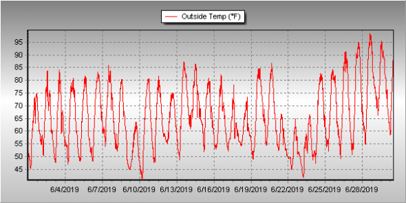
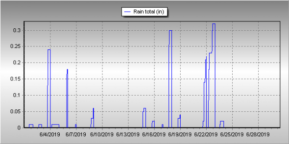
Unsettled would be a good word to sum up Thornton’s weather for June 2019. We experienced a series of troughs and fronts that kept things unsettled and suppressed temperatures. That however did not translate into a great deal of precipitation.

Cooler than normal temperatures were seen across much of the month. Even the later part of June saw some days with high temperatures only in the 60s.

It wasn’t even until the 26th of the month that Denver and Thornton recorded their first 90 degree day of the year. This was in fact the fifth latest occurrence of a 90 degree day in Denver and the latest since 1982.

Thornton’s average temperature for the month came in at 65.7 degrees. This made the month the second coolest June Thornton has recorded in 13 years. Denver saw a virtually identical average of 65.6 degrees. Both readings were below the long term Denver average for June of 67.4 degrees.

Temperatures in Thornton ranged from a high of 98.5 degrees of the 28th of the month down to a low of 40.7 degrees on the morning of the 10th. Denver’s highest reading of 96 degrees came on the 29th and its coolest of 42 degrees on the 10th.

Denver averages 1.98 inches of precipitation during the month of June. This year, Thornton fell short of the mark while Denver exceeded it. Here in Thornton we tallied 1.51 inches while Denver saw 2.24 inches.

Click here to view Thornton’s June 2019 climate report.

Thornton, Colorado's June 2019 temperature summary. (ThorntonWeather.com)
Thornton, Colorado’s June 2019 temperature summary. (ThorntonWeather.com)
Thornton, Colorado's June 2019 precipitation summary. (ThorntonWeather.com)
Thornton, Colorado’s June 2019 precipitation summary. (ThorntonWeather.com)
CLIMATE REPORT
NATIONAL WEATHER SERVICE DENVER/BOULDER CO
1129 AM MDT MON JUL 1 2019

...................................

...THE DENVER CO CLIMATE SUMMARY FOR THE MONTH OF JUNE 2019...

CLIMATE NORMAL PERIOD 1981 TO 2010
CLIMATE RECORD PERIOD 1872 TO 2019

WEATHER         OBSERVED          NORMAL  DEPART  LAST YEAR`S
                 VALUE   DATE(S)  VALUE   FROM    VALUE  DATE(S)
                                          NORMAL
................................................................
TEMPERATURE (F)
RECORD
 HIGH             105   06/28/2018
                        06/26/2012
                        06/25/2012
 LOW               30   06/02/1951
HIGHEST            96   06/29       104      -8      105  06/28
                        06/28
LOWEST             42   06/10        30      12       44  06/02
                        06/09
AVG. MAXIMUM     80.1              82.4    -2.3     88.8
AVG. MINIMUM     51.2              52.3    -1.1     56.0
MEAN             65.6              67.4    -1.8     72.4
DAYS MAX >= 90      5               7.9    -2.9       16
DAYS MAX <= 32      0               0.0     0.0        0
DAYS MIN <= 32      0               0.0     0.0        0
DAYS MIN <= 0       0               0.0     0.0        0

PRECIPITATION (INCHES)
RECORD
 MAXIMUM         4.96   1882
 MINIMUM            T   1890
TOTALS           2.24              1.98    0.26     0.43
DAILY AVG.       0.07              0.07    0.00     0.01
DAYS >= .01        12               8.4     3.6        5
DAYS >= .10         6               4.6     1.4        2
DAYS >= .50         1               1.4    -0.4        0
DAYS >= 1.00        0               0.3    -0.3        0
GREATEST
 24 HR. TOTAL    0.97   06/18 TO 06/18

SNOWFALL (INCHES)
RECORDS
 TOTAL             MM   MM
TOTALS            0.0               0.0

DEGREE_DAYS
HEATING TOTAL      62                62       0        9
 SINCE 7/1       6281              6058     223     5410
COOLING TOTAL      87               133     -46      241
 SINCE 1/1         92               155     -63      289

FREEZE DATES
RECORD
 EARLIEST     09/08/1962
 LATEST       06/08/2007
EARLIEST      10/10             10/07
LATEST        05/22             05/05
.................................................................

WIND (MPH)
AVERAGE WIND SPEED              9.7
RESULTANT WIND SPEED/DIRECTION   3/182
HIGHEST WIND SPEED/DIRECTION    43/180    DATE  06/02
HIGHEST GUST SPEED/DIRECTION    56/200    DATE  06/02

SKY COVER
POSSIBLE SUNSHINE (PERCENT)   MM
AVERAGE SKY COVER           0.60
NUMBER OF DAYS FAIR            1
NUMBER OF DAYS PC             26
NUMBER OF DAYS CLOUDY          3

AVERAGE RH (PERCENT)     54

WEATHER CONDITIONS. NUMBER OF DAYS WITH
  0
  5
  0
  1
  0
  0
  1
HAZE                      2

-  INDICATES NEGATIVE NUMBERS.
R  INDICATES RECORD WAS SET OR TIED.
MM INDICATES DATA IS MISSING.
T  INDICATES TRACE AMOUNT.

June 2019 top shots: Monthly photo slideshow

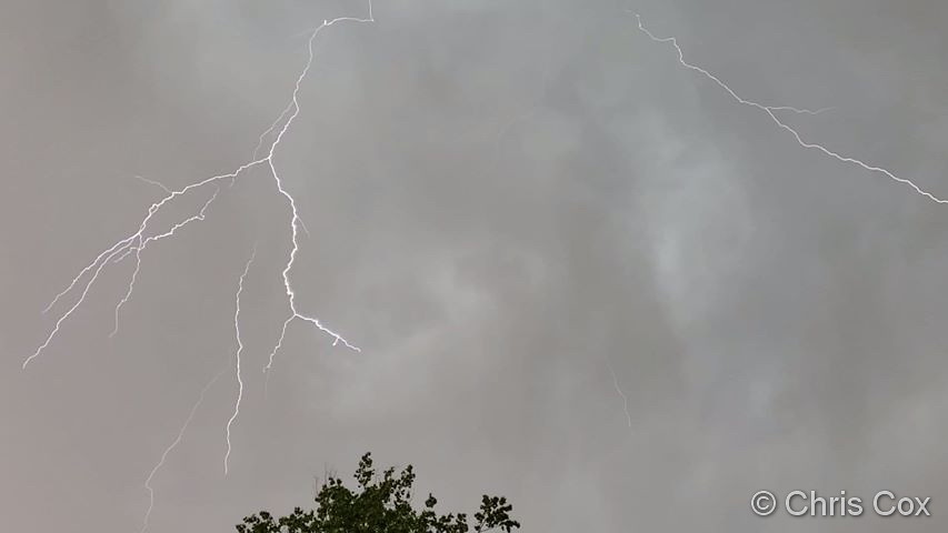
Lightning streaks across the skies over Thornton. (Chris Cox)

The month of June typically sees springtime severe weather reach its height of activity in northeastern Colorado.

This affords the opportunity to capture extraordinary images of amazing weather phenomena from monstrous supercell thunderstorms to heavy rain, hail and even tornadoes.

  • Slideshow updated June 30, 2019

Showcasing images captured by ThorntonWeather.com readers as well as some of our own, our monthly slideshow covers the entire gamut of weather and nature related imagery.

Sunsets, sunrises, wildlife and of course every type of weather condition are vividly depicted.  June brings some very dynamic weather and the photos are a great way to see the stunning variety.

To learn more about how to send your photo to us for inclusion in the slideshow, see below the slideshow.

[flickr_set id=”72157708942513328″]

What is missing in the slideshow above?  Your photo!

Our monthly photo slideshow is going to feature images that we have taken but more importantly images that you have captured.  The photos can be of anything even remotely weather-related.

Landscapes, current conditions, wildlife, pets, kids.  Whimsical, newsy, artsy.  Taken at the zoo, some other area attraction, a local park, a national park or your backyard.  You name it, we want to see and share it!

Images can be taken in Thornton, Denver or anywhere across the extraordinary Centennial State.  We’ll even take some from out of state if we can tie it to Colorado somehow.

We’ll keep the criteria very open to interpretation with just about any image eligible to be shown in our slideshows.

What do you win for having your image in our slideshow?  We are just a ‘mom and pop’ outfit and make no money from our site so we really don’t have the means to provide prizes.  However you will have our undying gratitude and the satisfaction that your images are shared on the most popular website in Thornton.

To share you images with us and get them included in the slideshow just email them to us or share them with ThorntonWeather.com on any of the various social media outlets.  Links are provided below.

So come on, get those camera’s rolling!

Thornton’s June weather preview: Temperatures and severe weather heat up

Thornton's June weather preview.Extreme weather can occur during in month in Colorado we well know.  June however is when traditional spring severe weather arrives in the state oftentimes with hail, damaging wind and tornadoes.
Over 40 percent of the tornadoes that occur in Colorado happen during the month of June.  Far more common are thunderstorms with hail and wind, each responsible for extensive damage each year.

While severe weather is common, so too are brilliantly sunny and mild days as we close out spring and enter summer.  If you are looking for cold, it isn’t likely but it is possible as the Denver area has seen freezing temperatures and yes, even snow, during the month.

Read more about Thornton and Denver’s June weather and a look ahead at this year.

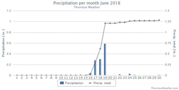
June 2018 weather recap: Another warm, dry month

The running theme so far for 2018 seems to be warmer than normal temperatures and drier that average conditions.  That trend continued in June for Thornton.

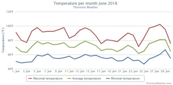
Like May, June was somewhat a tale of two halves.  The first half of the month was marked by very dry conditions with no precipitation until the 16th of the month. Similarly, overall temperatures trended well above normal during the first half of June.

While the warm and dry conditions were notable, the most memorable weather event came on the evening of the 18th when large hail pounded the northern half of Thornton.  Extensive damage to homes and vehicles was seen as hailstones pushing 2 inches in diameter struck.

The month also featured Thornton’s hottest mercury reading in six years. We saw a high of 102.4 degrees on the 28th.  You have to go back to June 25, 2012 to find a warmer reading (102.9). Additionally, the reading ties for the second warmest high temperature ThorntonWeather.com has recorded since coming online in 2007.

Thornton saw an overall average temperature for the month of 71.3 degrees. This was well above the 30 year average June temperature for Denver of 67.4 degrees. Out at DIA where Denver’s official measurements are taken, it was even warmer with an average for the month of 72.4 degrees.

Temperatures ranged from a high of 102.4 degrees on the 28th down to a low of 46.8 degrees on the morning of the 25th.  The Mile High City saw it warmest reading of 105 on the 28th as well and its coldest reading of 44 degrees on the 2nd.

The National Weather Service reports that June 2018 will go into the books as the seventh warmest June on record for Denver.  Additionally, three days saw record tying or setting highs. The 5th brought a record high of 95 degrees, the 6th saw a record-tying high of 95 degrees and the 105 degree reading on the 28th was a record for that date.

Denver averages 1.98 inches of precipitation during the month of June. Both Thornton and Denver fell short of that mark.  Thornton saw 1.28 inches fall in its rain bucket while at the airport, it was even drier with only 0.43 inches.

Click here to view Thornton’s June 2018 climate report.

June 2018 temperature summary chart for Thornton, Colorado. (ThorntonWeather.com)
June 2018 precipitation summary chart for Thornton, Colorado. (ThorntonWeather.com)
CLIMATE REPORT
NATIONAL WEATHER SERVICE DENVER/BOULDER CO
320 PM MDT SUN JUL 1 2018

...................................

...THE DENVER CO CLIMATE SUMMARY FOR THE MONTH OF JUNE 2018...

CLIMATE NORMAL PERIOD 1981 TO 2010
CLIMATE RECORD PERIOD 1872 TO 2018

WEATHER         OBSERVED          NORMAL  DEPART  LAST YEAR`S
                 VALUE   DATE(S)  VALUE   FROM    VALUE  DATE(S)
                                          NORMAL
................................................................
TEMPERATURE (F)
RECORD
 HIGH             105   06/28/2018
                        06/26/2012
                        06/25/2012
 LOW               30   06/02/1951
HIGHEST           105R  06/28       104       1       99  06/20
LOWEST             44   06/02        30      14       42  06/13
AVG. MAXIMUM     88.8              82.4     6.4     85.5
AVG. MINIMUM     56.0              52.3     3.7     53.6
MEAN             72.4              67.4     5.0     69.5
DAYS MAX >= 90     16               7.9     8.1        9
DAYS MAX <= 32      0               0.0     0.0        0
DAYS MIN <= 32      0               0.0     0.0        0
DAYS MIN <= 0       0               0.0     0.0        0

PRECIPITATION (INCHES)
RECORD
 MAXIMUM         4.96   1882
 MINIMUM            T   1890
TOTALS           0.43              1.98   -1.55     0.33
DAILY AVG.       0.01              0.07   -0.06     0.01
DAYS >= .01         5               8.4    -3.4        5
DAYS >= .10         2               4.6    -2.6        2
DAYS >= .50         0               1.4    -1.4        0
DAYS >= 1.00        0               0.3    -0.3        0
GREATEST
 24 HR. TOTAL    0.25   06/17 TO 06/17

SNOWFALL (INCHES)
TOTAL             0.0               0.0
RECORD            0.4   1919

DEGREE_DAYS
HEATING TOTAL       9                62     -53       25
 SINCE 7/1       5410              6058    -648     5109
COOLING TOTAL     241               133     108      167
 SINCE 1/1        289               155     134      173

FREEZE DATES
RECORD
 EARLIEST     09/08/1962
 LATEST       06/08/2007
EARLIEST                        10/07
LATEST                          05/05
.................................................................

WIND (MPH)
AVERAGE WIND SPEED              10.5
RESULTANT WIND SPEED/DIRECTION   1/129
HIGHEST WIND SPEED/DIRECTION    40/240    DATE  06/05
HIGHEST GUST SPEED/DIRECTION    57/160    DATE  06/27

SKY COVER
AVERAGE SKY COVER               0.40
NUMBER OF DAYS FAIR               11
NUMBER OF DAYS PC                 16
NUMBER OF DAYS CLOUDY              3

AVERAGE RH (PERCENT)              42

WEATHER CONDITIONS. NUMBER OF DAYS WITH
THUNDERSTORMS            12   MIXED PRECIP           0
HEAVY RAIN                2   RAIN                   5
LIGHT RAIN                5   FREEZING RAIN          0
LT FREEZING RAIN          0   HAIL                   0
HEAVY SNOW                0   SNOW                   0
LIGHT SNOW                0   FOG W/VIS <=1/4 MILE   1
FOG                       5   HAZE                   2

-  INDICATES NEGATIVE NUMBERS.
R  INDICATES RECORD WAS SET OR TIED.
MM INDICATES DATA IS MISSING.
T  INDICATES TRACE AMOUNT.