Early spring can bring a wide variety of conditions from wintry storms to severe weather. Our look back at this week in Denver weather history shows that just about any type of weather condition can occur this time of year.
From the National Weather Service:
29-31
In 1970…snowfall totaled 6.0 inches at Stapleton International Airport. Heavy snow accumulation in Boulder on the 29th caused the collapse of a carport at an apartment building…damaging 11 automobiles. Northeast winds gusted to 24 mph at Stapleton International Airport.
30-31
In 1896…heavy snowfall totaled 7.5 inches in downtown Denver. Northwest winds gusted to 26 mph.
In 1897…rain changed to snow during the early morning of the 30th and totaled 6.2 inches before ending during the late morning of the 31st. Northwest winds were sustained to 35 mph with gusts to 46 mph.
In 1929…heavy snowfall of 7.0 inches was recorded over downtown Denver. Northwest winds were sustained to 23 mph on the 30th.
In 1953…heavy snowfall totaled 8.6 inches at Stapleton Airport where northeast winds gusted to 23 mph.
In 1955…a vigorous cold front produced north winds at 40 mph with gusts as high as 54 mph at Stapleton Airport. Rain and snow showers and blowing dust accompanied the front. Snowfall totaled only 0.1 inch at Stapleton Airport on the 31st.
In 1988…snow began falling on the afternoon of the 30th and continued through the 31st…burying metro Denver. Twelve to 18 inches of snow fell in the foothills to the west of Denver and Boulder with 6 to 12 inches across the rest of metro Denver. The storm disrupted aircraft operations at Stapleton International Airport where snowfall totaled 7.1 inches and north winds gusting to 32 mph reduced the visibility to less than 1/4 mile at times…causing air traffic delays of 2 to 3 hours.
In 2000…heavy snow once again developed over the foothills and the higher terrain to the south of metro Denver. Snowfall totals from the storm included: 16 inches atop Squaw Mountain…15 inches near Rollinsville…13 inches near Evergreen…12 inches near Morrison…11 inches in Coal Creek Canyon…10 inches near Blackhawk and in Eldorado Springs…9 inches at Ken Caryl Ranch and Larkspur… And 8 inches near Elizabeth. Snowfall totaled only 4.1 inches at the site of the former Stapleton International Airport. North winds gusted to 32 mph at Denver International Airport on the 30th.
In 2005…a strong spring storm intensified over the eastern plains of Colorado and produced near-blizzard conditions to the east and southeast of Denver overnight. North to northwest winds from 20 to 35 mph with gusts to 50 mph produced extensive blowing snow and caused near zero visibilities at times and snow drifts from 2 to 4 feet in depth. Snowfall amounts included: 12 inches near Bennett…8 inches around Castle Rock… 7 inches near Sedalia…and 6 inches near Parker. Only 0.3 inch of snow was reported at Denver Stapleton. At Denver International Airport…north winds gusted to 37 mph on the 30th and 36 mph on the 31st.
31
In 1873…high winds damaged buildings in the city. Northwest winds with sustained velocities to near 40 mph blew from 9:00 am until sunset.
In 1937…north to northeast winds sustained to 25 mph with gusts to 32 mph produced a light dust storm in the city during the afternoon.
In 1971…wind gusts to 92 mph were recorded in the south hills area of Boulder. At the National Bureau of Standards in Boulder sustained winds of 46 mph with gusts to 83 mph were measured. Damage was minor. Northwest winds gusted to 41 mph at Stapleton International Airport.
In 1983…high winds with gusts to 70 mph in Boulder caused minor damage.
31-1
In 1876…heavy snow began during the night and lasted all day on the 31st and through the morning of the 1st. The average depth of snow fall was 10 to 12 inches…but strong winds whipped the snow into drifts of 8 to 10 feet deep on the streets of the city. Precipitation from the storm was 1.03 inches on the 31st and 0.37 inch on the 1st.
In 1891…heavy moist snowfall totaled 18.0 inches in the city. Northeast winds were sustained to 20 mph with gusts to 24 mph on the 31st.
In 1936…northeast winds sustained to 21 mph produced a light dust storm in the city.
In 1975…a major storm dumped 9.3 inches of snowfall at Stapleton International Airport where northwest winds gusted to 41 mph. Rain changed to snow on the afternoon of the 31st…reducing the visibility to as low as 1/8 mile. Snow continued all day on the 1st and accumulated to a depth of 8 inches on the ground. The minimum temperature of 10 degrees on the 1st set a new record low for the date.
As we have witnessed in recent days, significant snow events can make an appearance in Denver during the month of March and there have been a number of them in our past. Also not unusual and appearing are powerful, damaging winds. These types of events as well as thunderstorms, hail and even a tornado have occurred during this week in Denver weather history.
From the National Weather Service:
22-24
In 1965…a vigorous cold front swept across metro Denver late on the afternoon of the 22nd with east-northeast winds gusting to 38 mph causing some blowing dust. Snowfall from the storm totaled 4.4 inches at Stapleton International Airport. Temperatures on the 22nd dropped from a maximum of 63 degrees to 18 degrees in just 10 hours and dipped to 3 degrees below zero on the morning of the 24th. Maximum temperatures warmed to only 19 degrees on the 23rd and 18 degrees on the 24th.
23-24
In 1909…post-frontal rain on the 23rd changed to heavy snow during the evening and continued through the morning of the 24th. Snowfall totaled 13.8 inches. Rain and melted snow… Totaled 2.43 inches…which was the record greatest 24 hour precipitation ever recorded in March at that time. A thunderstorm of moderate intensity occurred on the 23rd in advance of the cold front. North winds were sustained to 27 mph overnight.
In 1990…several hours of freezing drizzle covered roadways with a thin layer of “black ice” which caused nearly 100 traffic accidents across metro Denver. In Boulder…snow and freezing rain caused numerous accidents and brief power outages. Snow in Boulder ranged from an inch east of town to 4 to 5 inches near Table Mesa. At times thunder was heard during the snow. Snowfall totaled only 0.6 inch at Stapleton International Airport where northwest winds gusted to 30 mph on the 23rd.
In 1995…high winds developed late on the 23rd and continued through the 24th. A few windows were blown out of a Denver high rise building…spraying glass on the sidewalks and streets below. Southeast winds gusted to 48 mph at Denver International Airport on the 23rd.
In 1996…the third storm in 10 days brought heavy snow to the mountains…foothills…and metro Denver. Snowfall totaled 18 inches at Golden Gate Canyon and 10 inches at Nederland in the foothills. Across metro Denver… Snowfall ranged from 4 to 8 inches. At the site of the former Stapleton International Airport…snowfall totaled 6.5 inches with most of the snow occurring on the 24th. North winds gusted to 34 mph at Denver International Airport. As the storm moved east on the 24th and 25th… Blizzard conditions developed over northeastern Colorado closing both I-70 and I-76 east of Denver.
In 2010…a powerful spring snowstorm swept across northern Colorado. The heaviest snowfall occurred in and near the Front Range foothills and deep upslope developed. The heavy…wet snow clung to tree limbs and power lines…which caused 36500 electrical outages throughout Denver and the surrounding metro area. Power outages also occurred in Douglas and Elbert counties. In addition…approximately 5 thousand travelers were stranded at Denver International Airport due to flight cancellations and delays. Initially… The snow fell at a rate of 2 to 4 inches per hour…between Boulder and Denver…bringing the evening rush hour to a complete halt. Countless motorists were stuck on U.S. Highway 36 for several hours. Other road closures included I-70…from Idaho Springs to Genesee and I-25 in both directions…from Lincoln Avenue south to Greenland… Or about 15 miles south of Castle Rock. In and near the Front Range foothills and Palmer Ridge…storm totals included: 26 inches at Coal Creek Canyon…23.5 inches…3 miles south of Evergreen; 22 inches at Aspen Springs…13 miles northwest of Golden and 3 miles west of Jamestown; 21.5 inches…3 miles north of Blackhawk…20 inches at Genesee; 16 inches near Nederland; 14 inches near Elizabeth and Strontia Springs dam; 13 inches at Bergen Park and 3 miles southeast of Indian Hills; 12.5 inches… 3 miles southwest of Conifer; 11.5 inches at St. Mary’s Glacier. In Denver and the surrounding suburbs…storm totals included: 15 inches at lone tree; 14 inches near Highlands Ranch; 13 inches near Louisville…12.5 inches at Aurora…Commerce City…Englewood and 5 miles west of Littleton; 12 inches at Erie and Greenwood Village; 11 inches at Ralston Reservoir and Westminster; 10.5 inches at the national weather service in Boulder…10 inches… 4 miles northeast of Castle Rock…Fredrick…Lakewood…3 miles southeast of Morrison and 4 miles southeast of Watkins; 9.5 inches…3 miles southeast of Denver; 9 inches in Broomfield…Lafayette…Northglenn and Thornton; 8.5 inches near Federal Heights; 8 inches in Arvada… Brighton and Wheat Ridge; 6 inches…5 miles southwest of Hudson. Officially…10.8 inches of snow was measured at Denver International Airport.
23-25
In 1891…rain changed to snow and totaled 8.8 inches in downtown Denver. Most of the snow fell on the 24th. Winds were light.
In 1964…heavy snowfall of 5.8 inches was measured at Stapleton International Airport. North-northeast winds gusted to 21 mph behind a cold front.
The snow is falling, the wind is blowing and it is cold and nasty out there right now. We took to the street for a little bit to capture some video of our late spring snowstorm. Highlights include the flag flapping in the wind, blowing snow, shoveling and even an appearance by Scout, our Frisbee catching dog who doesn’t mind the snow one bit.
Update, 4:45pm: Below the first video taken this morning is a second video captured from our east facing webcam. It is a time lapse showing the past 24 hours compressed into 48 seconds.
March weather can be gorgeous but it can also be nasty with a healthy dose of any of the four seasons. Our look back at this week highlights this with a number of notable weather events from powerful, damaging winds to landspout tornadoes and of course monstrous snow storms.
From the National Weather Service:
9-19
In 1906…an extended cold and blustery period occurred with light snow totaling 14.4 inches over 11 consecutive days. The greatest amount of snow on a single day was 4.0 inches on the 15th. Only a trace of snow fell on the 12th and 17th. High temperatures were below freezing for the entire period. The coldest were 14 degrees on the 16th and 18 degrees on the 17th. Both readings were record low maximums for the dates. Low temperatures were mostly in the single digits. The coldest were 2 degrees below zero on the 16th and 5 degrees below zero on the 19th. Northeast winds were sustained to 22 mph on the 9th. North winds were sustained to 36 mph on the 10th…32 mph on the 13th…and 22 mph on the 15th.
17
In 1966…high winds caused extensive minor damage across metro Denver. A light plane was overturned at Stapleton International Airport where northwest wind gusts to 55 mph were recorded. Winds gusted to 56 mph at Table Mesa in Boulder
In 1989…strong winds raked metro Denver. West wind gusts to 49 mph were clocked at Stapleton International Airport.
In 2003…the first tornado of the season was sighted near Strasburg. The small landspout touched down briefly…but caused no damage.
17-18
In 1923…4.2 inches of snow fell over downtown Denver. Northwest winds were sustained to 45 mph with gusts to 49 on the 17th. Low temperature of zero degrees on the 18th was the lowest of the month that year.
In 1944…heavy snow fell across metro Denver. The storm started as rain on the 17th…but soon turned to snow. Snowfall amounts totaled 8.5 inches in downtown Denver and 11.0 inches at Stapleton Airport. The highest wind recorded during the storm was 23 mph on the 17th.
In 1961…a major winter storm dumped 10.7 inches of snow at Stapleton Airport. Most of the snow…9.7 inches…fell on the 18th. Winds were light.
In 1994…strong winds buffeted metro Denver. West winds gusted to 51 mph at Stapleton International Airport on the 17th. Other significant wind gusts included 85 mph atop Squaw Mountain south of Idaho Springs…and 82 mph at Rollinsville southwest of Boulder…both on the 18th.
In 1996…a second storm in less than 3 days dumped heavy snow in the mountains and foothills again…but snowfall amounts across metro Denver ranged from only 2 to 4 inches. The heavy snowfall resulted in several traffic accidents along I-25 and I-70…south and west of Denver respectively. The major accidents involved at least 30 cars and resulted in several minor injuries. The accidents closed both highways for a time. Snowfall totals included 13 inches at Evergreen and 10 inches at Conifer. Snowfall totaled only 0.7 inch at the site of the former Stapleton International Airport. At Denver International Airport… North winds gusted to 28 mph on the 17th and 39 mph on the 18th.
17-19
In 1933…rain changed to snow on the evening of the 17th and continued through mid-day of the 19th. Snowfall totaled 5.6 inches with 0.83 inch of precipitation in in the city. North winds were sustained to 38 mph with gusts to 46 mph on the 18th and to 30 mph with gusts to 43 mph on the 19th.
In 2003…one of the worst blizzards since historic records began in 1872 struck metro Denver with a vengeance. Heavy wet snow accumulating to around 3 feet in the city and to more than 7 feet in the foothills brought transportation to a near standstill. North winds sustained to 30 mph with gusts as high as 41 mph produced drifts to 6 feet in the city. The estimated cost of property damage alone…not including large commercial buildings…was 93 million dollars… Making it the costliest snowstorm ever. Mayor Wellington Webb of Denver said…”this is the storm of the century…a backbreaker…a record breaker…a roof breaker.” Two people died in Aurora from heart attacks after shoveling the heavy wet snow. The National Guard sent 40 soldiers and 20 heavy duty vehicles to rescue stranded travelers along I-70 east of Gun Club Road. The heavy wet snow caused roofs of homes and businesses to collapse. The snow also downed trees… Branches…and power lines. Two people were injured when the roofs of their homes collapsed. In Denver alone…at least 258 structures were damaged. In Arvada…a roof collapse at west gate stables killed a horse. Up to 135 thousand people lost power during the storm…and it took several days for power to be restored in some areas. Denver International Airport was closed…stranding about 4000 travelers. The weight of the heavy snow caused a 40-foot gash in a portion of the tent roof…forcing the evacuation of that section of the main terminal building. Avalanches in the mountains and foothills closed many roads…including I-70…stranding hundreds of skiers and travelers. Along I-70…an avalanche released by the Colorado department of transportation…blocked the interstate in both directions for several hours. Several residences between Bakerville and Silver Plume were evacuated because of the high avalanche danger. At Eldora Ski Area…270 skiers were stranded when an avalanche closed the main access road. After the storm ended…a military helicopter had to ferry food to the resort until the road could be cleared. The heavy snow trapped thousands of residents in their foothills homes in Jefferson County for several days. Two homes burned to the ground when fire crews could not reach the residences. Some schools remained closed well into the following week. The storm officially dumped 31.8 inches of snow at the site of the former Stapleton International Airport…the most snowfall from a single storm since the all-time record snowfall of 37.5 inches on December 4-5…1913. The storm made March 2003 the snowiest March on record…the 4th snowiest month on record… And the 5th wettest March on record. The 22.9 inches of snow on the 18th into the 19th was the greatest 24 hour snowfall ever recorded in the city during the month of March. The storm was also a drought-buster…breaking 19 consecutive months of below normal precipitation in the city. Snowfall across metro Denver ranged from 2 feet to more than 3 feet. The highest amounts included: 40 inches in Aurora…38 inches in centennial and 6 miles east of Parker…37 inches at Buckley AFB…35 inches in southwest Denver…34 inches in Louisville… 32 inches in Arvada…31 inches in Broomfield and Westminster… And 22.5 inches in Boulder. In the foothills…snowfall ranged from 3 feet to more than 7 feet. Some of the most impressive storm totals included: 87.5 inches atop Fritz Peak and in Rollinsville…83 inches at cabin creek…74 inches near Bergen Park…73 inches northwest of Evergreen…72 inches in Coal Creek Canyon…70 inches at Georgetown…63 inches near Jamestown…60 inches near Blackhawk…55 inches at Eldora Ski Area…54 inches 8 miles west of Sedalia…and 46.6 inches at Ken Caryl Ranch. The storm was the result of a very moist…intense slow moving pacific system which tracked across the four corners and into southeastern Colorado…which allowed deep easterly upslope flow to form along the Front Range.
18
In 1883…0.3 inch of snow fell in downtown Denver. This was the only measurable snowfall of the month.
In 1903…rain changed to sleet and then to snow…which became heavy. Post-frontal snowfall totaled 7.0 inches over the city. North winds were sustained to 51 mph with gusts as high as 60 mph.
In 1905…northwest winds were sustained to 42 mph.
In 1914…northeast winds were sustained to 46 mph with gusts to 56 mph behind a strong cold front. Snowfall was 3.4 inches over the city…but most of the snow melted as it fell. The estimated amount of melted snow was 8.1 inches.
In 1920…a terrific windstorm occurred along the eastern foothills. Two deaths were attributed to the storm and some damage occurred. Both Denver and Boulder were affected by the strong winds. West winds were sustained to 51 mph with gusts as high as 66 mph in downtown Denver. The strong winds did considerable damage to property… Wires…plate glass windows…and indirectly loss by fire. The wind caused the death of one young girl by toppling the side of a brick building on her as she was standing on a corner waiting for a car. The wind was also responsible for several severe auto accidents due to blowing debris into the streets and blowing dust and dirt into the eyes of drivers.
In 1954…west winds at sustained speeds of 40 mph and gusts as high as 56 mph produced some blowing dust at Stapleton Airport.
In 1979…heavy snow totaled 4 to 12 inches along the Front Range from Denver north. I-25 was closed for a brief time between Denver and Cheyenne. New snowfall totaled 4.3 inches at Stapleton International Airport where north winds gusted to 29 mph.
In 1998…a major winter storm dumped heavy snow over areas west from I-25 to the continental divide as strong upslope conditions developed. Two to 3 1/2 feet of snow fell in the foothills with 1 to 2 feet reported in west metro Denver. Snowfall totals included: 38 inches at Silver Spruce Ranch…2 miles south of Ward; 35 inches at Aspen Springs; 33 inches near Blackhawk; 30 inches at Eldora; 29 inches in Coal Creek Canyon; 27 inches at Conifer… Chief Hosa…and Nederland; 25 inches at Rollinsville and Gross Reservoir; 21 inches at Evergreen; and 15 to 19 inches at Broomfield…Lakewood…and Table Mesa in Boulder. Elsewhere across metro Denver…snowfall ranged from 8 to 14 inches. Snowfall totaled only 7.9 inches at the site of the former Stapleton International Airport. East winds gusted to 31 mph at Denver International Airport.
Heavy, wet snow is the hallmark of March in Denver and we see many events containing just that in our look back at this week in Denver weather history.
From the National Weather Service:
8-10
In 1989…unusually warm weather set four daily temperature records in Denver. The high temperature of 74 degrees on the 8th exceeded the record. Records were equaled on the 9th with a high of 77 degrees and the 10th with a high of 79 degrees. The low temperature of 42 degrees on the 10th set a new record high minimum for the date.
9-10
In 1904…strong Chinook winds raked the city for 2 days. On the 9th…west winds sustained to 53 mph with gusts to 62 mph warmed the temperature to a high of 55 degrees. On the 10th… West winds were sustained to 48 mph with gusts to 54 mph. The high temperature was 58 degrees.
9-11
In 1927…rain changed to heavy snow behind a cold front and totaled 7.7 inches over downtown Denver. North winds were sustained to 37 mph with an extreme velocity to 38 mph on the 11th.
In 1955…a strong windstorm raked the eastern foothills. A wind gust to 95 mph was recorded at Rocky Flats with a gust to 60 mph measured at Valmont. Damage in Boulder totaled 10 thousand dollars. Minor injuries also occurred. The strong winds were associated with a vigorous cold front that produced northwest winds at 40 mph with gusts as high as 52 mph at Stapleton Airport where the visibility was briefly reduced to 3/4 mile in blowing dust on the 10th.
In 1968…5.5 inches of snow fell at Stapleton International Airport where northeast winds gusted to 24 mph on the 10th.
9-19
In 1906…an extended cold and blustery period occurred with light snow totaling 14.4 inches over 11 consecutive days. The greatest amount of snow on a single day was 4.0 inches on the 15th. Only a trace of snow fell on the 12th and 17th. High temperatures were below freezing for the entire period. The coldest were 14 degrees on the 16th and 18 degrees on the 17th. Both readings were record low maximums for the dates. Low temperatures were mostly in the single digits. The coldest were 2 degrees below zero on the 16th and 5 degrees below zero on the 19th. Northeast winds were sustained to 22 mph on the 9th. North winds were sustained to 36 mph on the 10th…32 mph on the 13th…and 22 mph on the 15th.
10
In 1893…northwest winds were sustained to 48 mph with gusts to 60 mph in the city.
In 1948…the high temperature warmed to only 6 degrees… The all-time record low maximum for the month of March. The same reading also occurred on March 6…1920.
In 1970…5.0 inches of snow fell at Stapleton International Airport where north winds gusted to 21 mph.
Perhaps we could call it the ‘Daylight Savings Storm of 2013’ or some other lame name like the Weather Channel uses. Then again, we will stick with simply calling yesterday’s snowstorm a late winter storm that brought much-needed precipitation.
Leading up to yesterday’s storm all indicators were there for a significant shot of snow. Forecasts varied a bit from outlet to outlet and some were disappointed that we didn’t receive as much as some forecasts said. However within range with our forecasts for Thornton.
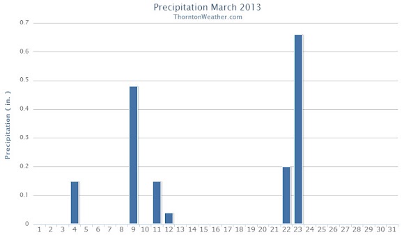
Snow began falling during the 4:00am hour on Saturday, March 9 and would continue for nearly 12 hours. It was the first six hours that the most accumulation was recorded. After that relatively warm temperatures and warm ground melted the snow as fast – and faster – than it was falling.
The one benefit of the fast melting is that Denver metro area roads never really became all that bad. The story was quite different on the plains to the east where blowing snow prompted the closure of Interstate 70 for 24 hours or so. Denver International Airport (DIA) did have more than 600 flights cancelled.
At its highest we recorded 5.6 inches of snow on the ground. More than that certainly fell but the melting was taking its toll. This brings Thornton’s seasonal snowfall total to 34.5 inches.
Officially Denver recorded 5.4 inches as measured at Denver International Airport. The Mile High City’s seasonal total is now at 38.5 inches.
Best of all the heavy, wet snow contained a great deal of liquid precipitation. Thornton saw 0.48 inch of precipitation and Denver 0.27 inch. As parched as our landscape has been this winter this is very welcome.
Below is a time lapse video from our east webcam of the storm from start to finish – 14 hours in 28 seconds. Scroll down below that for an interactive map of snowfall totals from across northeastern Colorado.
The month of March sometimes brings with it some of our most interesting weather with a wide variety of conditions possible. Our look back at this week in Denver weather history showcases this fact as we see damaging, high wind events, monster snow storms, and even thunderstorms.
From the National Weather Service:
2-3
In 1901…strong northwest winds raked the city for 2 days. On the 2nd…winds were sustained to 55 mph with gusts to 62 mph. The Chinook winds warmed the temperature to a high of 72 degrees…a record maximum for the date. On the 3rd…winds were sustained to 61 mph with gusts as high as 65 mph. The high temperature was 59 degrees.
In 1964…heavy snowfall of 6.3 inches was measured at Stapleton International Airport. East winds gusted to only 20 mph behind a cold front.
In 1978…5.0 inches of snowfall were measured at Stapleton International Airport where northeast winds gusted to 24 mph on the 2nd. The passage of a cold Canadian front kept temperatures only in the teens and 20’s on the 2nd after a high temperature of 33 degrees shortly after midnight. The temperature…after a morning low of 3 degrees below zero…climbed to only 14 degrees on the 3rd…setting a record low maximum for the date.
2-4
In 1963…heavy wet snow was accompanied by strong gusty winds across metro Denver. Snowfall totaled 11.6 inches at Stapleton Airport where north winds gusting to 44 mph caused much blowing and drifting snow. Hazardous driving conditions resulted in many traffic accidents.
In 1976…snowfall totaled 8.0 inches at Stapleton International Airport where…on the 4th…northeast winds gusted to 31 mph reducing the visibility to as low as 1/4 mile. Maximum snow depth on the ground was 7 inches. Nine inches of snow were measured in Boulder.
3
In 1875…six inches of snow fell in Georgetown.
In 1895…northwest bora winds were sustained to 45 mph with gusts to 58 mph in the city.
In 1966…cold northwest wind gusts of 50 to 90 mph occurred across metro Denver. Both cars and trucks were blown off an icy highway just east of Denver where some highways were closed by either blowing dust or blowing snow. A northwest wind gust to 43 mph was recorded at Stapleton International Airport. The strong winds caused limited minor damage.
In 1972…winds gusted to 55 mph in Boulder causing no reported damage. West winds gusted to 49 mph at Stapleton International Airport.
In 1985…snow struck metro Denver. Heaviest hit was Boulder where 6 to 8 inches were measured. Icy roads caused the closure of I-25 north and south of Denver due to traffic accidents. The snow also caused long delays at Stapleton International Airport where snowfall totaled only 2.6 inches.
In 1997…west winds gusted to 52 mph at Denver International Airport.
3-4
In 1932…a dust storm occurred on the 3rd during the late afternoon. North winds gusting as high as 38 mph behind a cold front kicked up much blowing dust. Light snow developed during the evening and continued through the early morning of the 4th. Snowfall totaled 2.7 inches.
In 1934…strong winds raked Boulder. A wind gust to 62 mph was recorded at Valmont just east of Boulder. The strong winds caused hundreds of dollars of damage in Boulder.
In 1981…the most vigorous snow storm of the season struck the state…closing many schools and most highways connecting Denver…Colorado Springs…and Limon. North winds gusting to 43 mph whipped nearly 10 inches of snow in Denver into 3-foot drifts and snarled traffic on the morning of the 4th. Snowfall totaled 9.8 inches at Stapleton International Airport.
In 1989…a storm dumped 2 to 6 inches of snow across metro Denver. The snow caused 2-hour air traffic delays at Stapleton International Airport where 3.0 inches of snow fell and north winds gusted to 23 mph on the 3rd. There were many traffic accidents across metro Denver. I-70 was closed east of Denver for a time on the 3rd.
In 1991…high winds raked the eastern foothills. Wind gusts of 60 to 90 mph were common with 119 mph recorded at Wondervu southwest of Boulder…106 mph on Shanahan Ridge and 92 mph at Table Mesa…both in southwest Boulder. Several trees were uprooted and traffic signs and lights blown over. Flying debris caused damage to homes… Buildings…and cars.
In Boulder…a stop sign was blown onto a car. There were no reports of injuries. Southwest winds gusting as high as 48 mph briefly reduced the prevailing visibility to as low as 1/16th mile in blowing dust at Stapleton International Airport on the 4th.
3-5
In 1961…snowfall totaled 8.3 inches at Stapleton Airport over the 3-day period with most of the snow…4.4 inches… Falling on the 3rd. Winds were generally light gusting to only 23 mph.
March is historically the Denver area’s snowiest month and only four days into it Mother Nature delivered a nice, wet shot of the white stuff. The storm moved through quickly Monday afternoon and now we focus on a potentially significant storm this coming weekend.
Today Thornton recorded 2.4 inches of snow and a very welcome 0.15” of liquid precipitation from it. Similar totals, many a bit less, were seen in other locations of the Denver metro area.
This brings Thornton’s seasonal snow total to 28.9 inches. That is still well below normal but given the progress made in recent weeks, we are hoping these storms continue to arrive.
As we discussed in this morning’s forecast, models are pointing toward a far more significant storm arriving as early as late Friday and lasting well into the weekend.
One model, the European ECMWF, has been relatively consistent with its projection of a powerful storm with a hefty shot of snow. Other models have been less optimistic but on later runs today they are starting to come in line with the same thinking.
The month of March in Denver is typically known for its snow and corresponding chilly temperatures. That however was certainly not the case for March 2012 as the Mile High City saw one of its warmest and driest Marches on record.
From the start of the month to the end, March’s temperatures were well above normal. While we would normally see days with temperatures in the 50s, we instead saw 70s and even a couple of 80+ degree days.
The historical overall average temperature for the month of March is 40.4 degrees (based on 1981 to 2010 normals). March 2012’s average of 49.2 degrees was an astonishing 8.8 degrees above normal.
This sends the month into the record books as the second warmest March ever recorded in Denver. The number one spot is held by March 1910 which saw an average of 50.4 degrees.
Here in Thornton, we were actually slightly warmer than the official Denver measuring station at DIA. Our monthly average temperature came in at 49.6 degrees.
Individually, six days set or tied high temperature records for Denver:
74 degrees on March 13 which tied the old record of 74 set in 2007 and previous years
75 degrees on March 16 which broke the old record of 74 set just one year ago in 2011
76 degrees on March 17 which broke the old record of 75 set in 1974
76 degrees on March 23 which tied the old record of 76 set in 1967
75 degrees on March 25 which tied the old record of 75 set in 1998 and previous years
81 degrees on March 31 which broke the old record of 80 set in 1946
In terms of precipitation, March 2012 will now hold the marks for the driest and least snowiest on record.
The rain bucket at Denver International Airport saw a mere 0.03 inch of liquid precipitation. This was far below the average of 0.92 inch and easily puts March 2012 into the books as the number one driest March on record. The previous record holder was 1908 when 0.11 inch was recorded.
March is historically Denver’s snowiest month averaging 10.7 inches. This year the month only brought a trace of snow on three days. The previous least snowiest March occurred in 1883 when 0.3 inch of the white stuff was recorded.
Just like Denver, Thornton saw an extraordinary lack of snow and precipitation. We as well recorded 0.03 inch of precipitation but we did manage to record 0.40 inch of snow, all on the morning of the 2nd.
CLIMATE REPORT
NATIONAL WEATHER SERVICE BOULDER, CO
1026 AM MDT SUN APR 1 2012
...................................
...THE DENVER CO CLIMATE SUMMARY FOR THE MONTH OF MARCH 2012...
CLIMATE NORMAL PERIOD 1981 TO 2010
CLIMATE RECORD PERIOD 1872 TO 2012
WEATHER OBSERVED NORMAL DEPART LAST YEAR`S
VALUE DATE(S) VALUE FROM VALUE DATE(S)
NORMAL
................................................................
TEMPERATURE (F)
RECORD
HIGH 84 03/26/1971
LOW -11 03/28/1886
HIGHEST 81 03/31 84 -3 76 03/21
LOWEST 16 03/02 -11 27 14 03/05
AVG. MAXIMUM 65.5 54.4 11.1 58.7
AVG. MINIMUM 32.9 26.4 6.5 27.8
MEAN 49.2 40.4 8.8 43.3
DAYS MAX >= 90 0 0.0 0.0 0
DAYS MAX <= 32 0 1.9 -1.9 1
DAYS MIN <= 32 14 23.6 -9.6 24
DAYS MIN <= 0 0 0.1 -0.1 0
PRECIPITATION (INCHES)
RECORD
MAXIMUM 4.56 1983
MINIMUM 0.11 1908
TOTALS 0.03R 0.92 -0.89 0.35
DAILY AVG. 0.00 0.03 -0.03 0.01
DAYS >= .01 2 5.9 -3.9 8
DAYS >= .10 0 2.4 -2.4 1
DAYS >= .50 0 0.3 -0.3 0
DAYS >= 1.00 0 0.1 -0.1 0
GREATEST
24 HR. TOTAL 0.03 03/01 TO 03/02 03/28 TO 03/28
03/28 TO 03/28
03/28 TO 03/28
STORM TOTAL MM MM
(MM/DD(HH)) MM 03/28(00) TO 03/28(00)
03/28(00) TO 03/28(00)8
SNOWFALL (INCHES)
RECORDS
TOTAL MM 5
TOTALS T 11.7
DEGREE_DAYS
HEATING TOTAL 483 763 -280 666
SINCE 7/1 4863 5202 -339 4817
COOLING TOTAL 0 0 0 0
SINCE 1/1 0 0 0 0
FREEZE DATES
RECORD
EARLIEST 09/08/1962
LATEST 06/08/2007
EARLIEST 10/07
LATEST 05/05
.........................................................
WIND (MPH)
AVERAGE WIND SPEED 11.5
RESULTANT WIND SPEED/DIRECTION 5/203
HIGHEST WIND SPEED/DIRECTION 46/180 DATE 03/18
HIGHEST GUST SPEED/DIRECTION 58/190 DATE 03/18
SKY COVER
POSSIBLE SUNSHINE (PERCENT) MM
AVERAGE SKY COVER 0.50
NUMBER OF DAYS FAIR 9
NUMBER OF DAYS PC 20
NUMBER OF DAYS CLOUDY 2
AVERAGE RH (PERCENT) 34
WEATHER CONDITIONS. NUMBER OF DAYS WITH
THUNDERSTORM 0 MIXED PRECIP 0
HEAVY RAIN 0 RAIN 0
LIGHT RAIN 0 FREEZING RAIN 0
LT FREEZING RAIN 1 HAIL 0
HEAVY SNOW 0 SNOW 0
LIGHT SNOW 2 SLEET 0
FOG 2 FOG W/VIS <= 1/4 MILE 0
HAZE 3
- INDICATES NEGATIVE NUMBERS.
R INDICATES RECORD WAS SET OR TIED.
MM INDICATES DATA IS MISSING.
T INDICATES TRACE AMOUNT.
$$
In stark contrast to the extremely dry and mild month we are experiencing now, March is normally known for its snow. In our look back at this week in Denver weather history we see many significant snow events that have occurred in the past and are much more representative of Denver’s March weather.
From the National Weather Service:
23-25
In 1891…rain changed to snow and totaled 8.8 inches in downtown Denver. Most of the snow fell on the 24th. Winds were light.
In 1964…heavy snowfall of 5.8 inches was measured at Stapleton International Airport. North-northeast winds gusted to 21 mph behind a cold front.
24-25
In 1904…west Bora winds sustained to 40 mph with gusts to 55 mph warmed the temperature to a high of 49 degrees on the 24th. Overnight…a cold front produced 4.5 inches of snow. The high temperature was only 34 degrees on the 25th.
In 1955…a vigorous cold front with winds sustained to 34 mph and gusts to 39 mph briefly reduced the visibility to 2 miles in blowing dust at Stapleton Airport. Post-frontal heavy snowfall totaled 9.5 inches at Stapleton Airport where the maximum snow depth on the ground was 7 inches.
24-26
In 1959…the second major spring storm in less than a week dumped 10 to 20 inches of wet snow across northeastern Colorado. Snowfall totaled 14.3 inches at Stapleton Airport where north winds gusted to 36 mph…causing near-blizzard conditions with visibilities frequently reduced to 1/2 mile in snow and blowing snow. Many travelers were marooned when trains…planes…and buses were unable to make their schedules. Utility lines were again damaged as a result of the storm.
25
In 1874…the wind blowing in gusts from the west-northwest filled the air with dust so dense that only the houses in the immediate neighborhood of the weather station could be recognized. The brisk winds continued through the afternoon.
In 1886…heavy snowfall of 6.5 inches occurred in the city.
In 1896…northwest winds sustained to 58 mph with gusts to 65 mph warmed the temperature to a high of 70 degrees.
In 1911…west winds were sustained to 43 mph. The Chinook winds warmed the temperature to a high of 65 degrees.
In 1925…northwest winds were sustained to 41 mph with gusts to 46 mph.
In 1950…strong Chinook winds gusted to 50 mph at Stapleton Airport.
In 1976…3.4 inches of snow fell at Stapleton International Airport where northeast winds gusted to 46 mph. The strong winds at 20 to 35 mph all day produced a rare “snirt” storm when blowing dust and dirt became mixed with snow and blowing snow reducing the visibility to as low as 1/4 mile at Stapleton International Airport.
In 1984…1 to 4 inches of new snow fell across metro Denver. Icy roads contributed to many accidents. The most hazardous conditions occurred in the foothills west of Denver. Both I-70 and U.S. 40 were closed at the height of the Sunday afternoon ski rush…causing delays of many hours. Snowfall totaled only 1.0 inch at Stapleton International Airport with only a trace on the ground due to melting.
In 1988…high winds in the mountains spread over metro Denver. A wind gust to 75 mph was noted in Boulder where a traffic light was downed. Power outages were reported in Boulder County. Northwest winds to 46 mph were recorded at Stapleton International Airport.